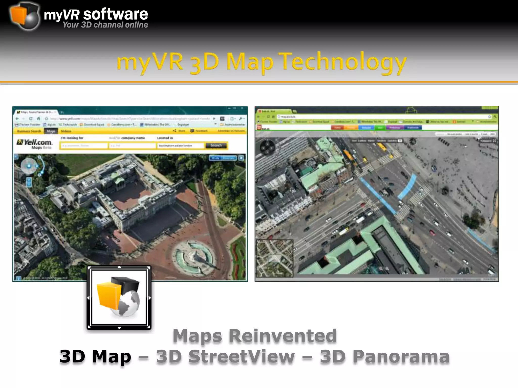
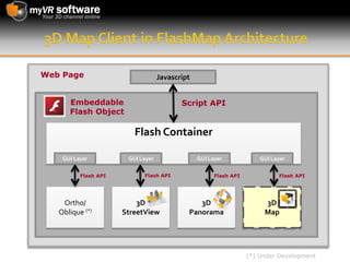
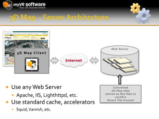
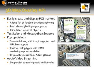
The myVR 3D Panorama viewer is perfect for showcasing real estate objects, destinations, products, restaurants and/or other businesses online etc. Furthermore, the 3D Panorama module is an integral module of our 3D FlashMap architecture, which allows for a seamless integration with our StreetView module to display "360 interior" imagery of local businesses.
IMGS Location Publisher Update_Simon McCabe - IMGS Government User Group 2013IMGS
The document provides an overview and update on Location Publisher and Location Publisher Mobile software. It discusses new features being added to version 4.3 like redlining and measurement tools. Location Publisher Mobile 4.3 will integrate with Location Publisher Forms Builder to allow capturing data in the field. The Location Publisher Dashboard is also highlighted which provides interactive maps and reports through a web browser. Roadmaps indicate Location Publisher 4.3 releasing in Q3 2013 and Location Publisher Mobile 4.3 integrating forms and releasing in Q4 2013.
IMGS Geospatial User Group 2014 - GeoMedia Smart Client Planning WorkflowsIMGS
The GeoMedia Smart Client provides advanced web editing and workflow optimization tools. It allows users to easily create customized workflows for managing geospatial data across an enterprise. The Smart Client includes tools for editing geometry and attributes, querying data, and generating maps and reports. It supports a variety of data sources and file formats. Workflow administrators can control data access and customize the user interface for specific workflows without costly development.
This document discusses cross-platform development strategies using Xamarin.Forms. It outlines how Xamarin.Forms allows for more code sharing while still using native platforms. Developers can create shared user interface code, including over 40 pages, layouts and controls. This shared UI code can then be rendered natively on Android, iOS and Windows platforms, while taking advantage of features like data binding, navigation, animation and messaging between platforms.
GeoMedia 2013, GIS Tools Where You Need Them_Ciaran Kirk - Intergraph Geospat...IMGS
GeoMedia 2013 Desktop provides tools for accessing, analyzing, and sharing geospatial data from various sources. It allows users to seamlessly access disparate data formats, capture and validate vector data to enterprise databases, and perform dynamic spatial analysis. Users can compose maps for printing or publishing, and export data to standard formats. The software is customizable and integrates with other products in Intergraph's geospatial portfolio.
The document presents a multimode interactive remote flight interface that provides a standardized UAV communications interface, runs on low-cost and commonly available hardware, and intuitively fuses manual and autonomous flight modes. Design drawings and charts outline the controller architecture, selling points compared to competition, and project milestones.
Force.com is a platform from Salesforce that allows building on-demand applications without much coding. Key features include a hosted, multi-tenant environment with no server maintenance; built-in functionality for data modeling, security, workflows and basic UI components; and the ability to customize through the Apex programming language and Visualforce markup. Common types of apps that can be built include CRM, email management, issue tracking and more. Building an app may involve using native platform functionality, custom data components, UI components, programming and more.
The document discusses the basics of Silverlight including its features, advantages, and architecture. It outlines Silverlight's capabilities such as replacing Flash/JavaScript, client-side C# scripting, responsiveness, cross-browser support, and accessing web services. Silverlight allows for rich media, 3D graphics, printing support, and accessing data via common protocols or ADO.NET objects. It also describes how to set up a Silverlight project, create an application manifest, and debug settings.
Microsoft Silverlight is a cross-browser plugin that delivers high quality media experiences and rich interactive applications to the web. It allows for stunning HD video, supports various media formats, and provides digital rights management. Silverlight also serves as a platform for building rich interactive applications using controls and styles. Developers can use Visual Studio and designers can use Expression Studio to build Silverlight applications and experiences.
Shine a Light with Prism (the Composite Application Guidance for WPF and Silv...Dave Bost
Prism is a library that provides guidance and tools for building composite client applications in WPF and Silverlight. It supports separating an application into modules and composing them at runtime. Prism provides features like module discovery, region-based UI composition, and an event aggregator for loose coupling. The library includes documentation, code samples, and a reference implementation to help developers build these types of applications while targeting both desktop and RIA scenarios.
The G.I.T. system was developed to effectively communicate comprehensive information about facilities to visitors through an up-to-date, interactive search of facilities and routes. The system offers a facility enquiry function, route searching function, and 360 degree views for property managers, land developers, and event planners. It was built using Visual Basic 2010, MS Access, Silverlight, and MS Image Composite Editor, with a client server model and modules for 360 degree image tours, search inquiries, and location maps stored on a database server.
Building Applications for SQL Server 2008Dave Bost
The document discusses new features in SQL Server 2008 including spatial data support, geography and geometry data types, table value parameters, date and time enhancements, and the MERGE statement. It also covers SQL CLR, reporting services, entity framework, and Visual Studio integration.
Leveraging Microsoft Dynamics CRM 4.0 as an application development platform to build real world business solutions that go beyond what you think of as "Just CRM." This presentation was delivered as part of Intergen's Twilight seminar series.
Sunil Mallya is a Microsoft Student Partner from PESIT, Bangalore, India. His email is sunil.mallya@student-partners.com. He discusses how user experience defines market categories and the importance of collaboration between designers and developers. Microsoft and third party tools can help streamline collaboration through features like XAML and help designers design and developers add business logic.
The document discusses the Midlogic development environment for creating customized mobile applications and content. It provides a powerful XML-based scripting language called MidXML for full customization, supports over 120 tags, and includes pre-built components for common UI scenarios. Developers can build user interfaces with boxes and populate them with item types and data. The platform automatically generates packages for different devices and languages.
The document discusses an innovative software that automates the process of creating detailed traffic signing and temporary traffic signing plans. It allows users to create sign assemblies with mounting types, multiple sign facings and status. Users can design sign facings from typical arrangements or build signs individually. Sign assemblies can then be placed and oriented along roadways. It also allows copying and editing of previous designs to increase productivity and generate customized reports of planned infrastructure.
1) The document discusses developing games for Windows Phone 7 using XNA. It provides an overview of the Windows Phone hardware platform and application platform.
2) It then summarizes the XNA game development framework, which allows for rapid creation of 2D and 3D games across Xbox, Windows, and other platforms.
3) Examples of XNA games for Windows Phone 7 are provided, including a popular duck hunting game, and a demonstration is offered. Questions are invited at the end.
Nearby is a mapping application that uses OpenStreetMap and GeoNames data to provide vector maps of Norway with additional points of interest and overlays. The app allows users to pan, zoom, and filter map layers. It includes dynamic overlays like weather, transit departures, and long press menus as well as static overlays like charging stations and recycling points. Nearby is available on iOS, Android, and through a mobile website.
IMGS Geospatial User Group 2014 - GeoMedia WebMap 2014IMGS
- Easily build and deploy interactive web sites or web services without programming
- Real-time access to enterprise geospatial data
- View, query and analyse geospatial data from many geospatial data formats without any pre-translation
- Perform powerful linear referencing and analysis capabilities including routing and dynamic segmentation web services
Solid Terrain Models that represent topographic in a realistic and accurate way.
People can gather around these models, touch and view from any angle, allowing an immediate perception of relief, orientation, slope, aspect or visibility.
3D maps are realistically printed with aerial photography, satellite imagery, maps graphics or text on the dimensional surface, so as the final result the scene comes alive.
Make Your LinkedIn Profile Visual and EngagingMARKITECT.me
FACTS: 1) 94% of job recruiters use or plan to use social media in their recruiting. 2) 78% of recruiters have made a hire through social media. ACTION: Learn how to differentiate yourself and add visual content to your LinkedIn profile in this presentation.
3D Geospatial Visualization Using Power Mapkristinferrier
This document summarizes a presentation about 3D geospatial visualization using Power Map. It introduces the presenter and discusses key topics like datums, Microsoft BI geospatial tools including SSRS, Power View, and Power Map. It provides details on Power Map like system requirements and examples of using it to visualize time-stamped 3D charts and animated tours of geographic data. The presentation concludes with instructions on getting started with Power Map and contact information.
The document discusses different methods for projecting 3D objects and scenes onto a 2D surface like a computer screen. It describes two main types of projections: perspective projections, which mimic how human vision works and introduce effects like foreshortening; and parallel projections, which do not include foreshortening but allow for easier measurement. Specific projection techniques covered include one-point, two-point, and three-point perspective, as well as orthographic, cavalier, and cabinet parallel projections. Key aspects like the center of projection and vanishing points are also explained.
Tim Jenks (eeGeo) gave a quick overview of how they built their indoor 3D mapping application with QGIS. Presented at the 6th Scottish QGIS UK user group meeting.
Touchless technology Seminar PresentationAparna Nk
This document discusses touchless technology that allows users to interact with screens without physically touching them. It describes a touchless monitor developed by TouchKo, White Electronics Designs, and Groupe 3D that uses sensors around the screen to detect 3D motions and interpret them as on-screen interactions. The document also mentions several other touchless technologies like the Touchless SDK, Touch Wall, eye tracking devices, gesture recognition tools, and motion sensors that enable touchless control of devices.
Lexical approach by umi darda, smstr 6 unit 4Syahyar Bahagia
The lexical approach is a method of language teaching developed in the 1990s that focuses on vocabulary learning and word combinations rather than grammar. It is based on the idea that understanding and using lexical phrases is central to language learning. The approach emphasizes accumulating vocabulary through meaningful chunks like collocations, idioms, and fixed expressions. While it aims to teach natural language use, the lexical approach provides little characterization of learning processes.
The Chief of Staff of the Army announced that the Army will reduce its number of brigade combat teams from 45 to 33 by the end of fiscal year 2017 due to force restructuring under the Budget Control Act of 2011. Ten brigade combat teams based in the continental United States will be inactivated, with one BCT being eliminated from each of the following installations: Fort Bliss, Texas; Fort Bragg, N.C.; Fort Campbell, Ky; Fort Carson, Colo.; Fort Drum, N.Y.; Fort Hood, Texas; Fort Knox, Ky.; Fort Riley, Kan.; Fort Stewart, Ga., and Joint Base Lewis-McChord, Wash. The Army's active duty end strength will also be reduced by 14
Technical overview of the myVR 3D FlashMap technology allowing photo realistic 3D maps to be displayed on any browser/platform using Adobe Flash version 9 or newer.
Multiverse is a complete MMOG technology platform that is available for free. It includes a server suite, graphical client, tools, and documentation. Developers can use the Multiverse platform to rapidly prototype and deploy their own virtual worlds and games. The Multiverse network allows all games and worlds built with the platform to be connected and accessible to players through a common World Browser client.
This document provides descriptions of various web and mobile applications developed using technologies like Flash/Flex, Java, and other front-end and backend frameworks. It includes summaries of applications for financial accounting, video players, games, e-learning, live chat, video conferencing and more. Links are provided for live demos of many of the applications.
Rain Concert - Rich Internet Application Development ExpertiseSeema Abhilash
This document provides descriptions of various web and mobile applications developed using technologies like Flash/Flex, Java, and other front-end and backend frameworks. It includes summaries of applications for financial accounting, video players, video conferencing, educational games/modules, e-commerce solutions, and more. Details on features, technologies used, and links to live demos are provided for each.
SuperMap GIS 8C is a full suite of GIS platform products that combines cloud, component, desktop, and mobile GIS capabilities. It features three key technologies: cloud-terminal integration GIS, 2D/3D integration GIS, and cross-platform GIS. The suite includes cloud and desktop GIS platforms, as well as SDKs for browser, mobile, and component development. It supports multiple operating systems and devices to provide a powerful, integrated GIS solution.
FlyCharts is a chart flash component, which is a set of Adobe Flash (SWF) files that gives you outstanding possibility to visualize your data. FlyCharts help create compact, interactive flash graphs, charts, diagrams fast and easy.
FlyCharts doesn't need installation, runs without using an Active-X component, reduces load on the server, works with any scripting language and can be used in any browser. It is interactive, scalable and flexible, with zooming and scrolling support. The component supports plenty of chart types - column/bar, line/pipe, pie, area, all 3D variations and even has multiple chart types support. The option of missing data support will never let the dataset miss as it's automatically restored as correctly visualized. All these come with really small size of output files (29Kb).
Data and component visual style comes from customizable XML file which gives unlimited possibilities in quick and easy tuning of the chart settings. If the user doesn't want to customize XML file manually, he can use FlyCharts online wizard that lets build charts quickly using user-friendly interface.
External JavaScript interface allows to use all browser development capabilities including Ajax technology. Combination of Ajax and FlyCharts gives an outstanding possibility to generate dynamic charts for different purposes. Besides FlyCharts can be easily integrated with DHTML Grid component.
If you want to create your own interactive and good-looking flash chart download trial version free for non-commercial use or check for FlyCharts buying options at the company's website http://flycharts.net
Powerful Geospatial Presentation Engine. Quickly enable Maps for Mobile Apps, Web, Embedded, and Desktop. Enhance your applications with the fastest multi content mobile mapping solution in the market, supporting a wide range of data/content sources and mobile platforms.
2D map, 3D map, GigaPixel images, 360 StreeView, 360 Panoramas, Vector Data etc. can now be displayed in your application in a geo oriented environment.
Visualization for the Manufacturing EnterpriseGermar Nikol
Kisters 3DViewStation:
- Your data; how, when, where you want
- Making visual data available for the enterprise
- Modern software technology and robust components
- Simple to deploy & use by all users with extensibility to
- sophisticated role based behavior
- Game changing lightning speed
Why 3DViewStation?
- Breadth of data
- MultiCAD 3D, PDF , graphics
- easily handles large/complex data
- Very Very FAST
- So you can stop waiting to see your data
Kisters 3DViewStation - CAD viewer for PLM and stand aloneGermar Nikol
Quick overview over Kisters 3DViewStation product family. Fast CAD viewer for PLM & stand alone usage. Modern UI, support all major CAD file formats like Catia V5, NX, ProE/Creo, JT, STEP, 3D-PDF and more. Export into various file formats incl 3D-PDF, JT, STEP, VRML... More at http://viewer.kisters.de
Maps for Mobile Apps - Fastest Multi Content Mobile Map SDK on the Market.
Enhance your mobile applications with the fastest multi content mobile mapping solution in the market, supporting a wide range of data/content sources and mobile platforms.
2D map, 3D map, GigaPixel images, 360 StreeView, 360 Panoramas, and PointClouds combined with POI’s/Overlays etc. can now be displayed on your mobile in a geo oriented environment.
Part of a course on multimedia document engineering, presented at EPFL during the Spring 2009 semester. Quick introduction to the W3C SVG specification and Model Driven User Interface Design.
Vineet Kumar proposes developing a cross-platform emulator for Phonegap applications. The emulator would allow testing Phonegap apps directly in a web browser by simulating mobile hardware using JavaScript, jQuery, Flash and other technologies. It would modify Phonegap's APIs to pass values from the simulated components to the app for testing, rather than accessing true native mobile APIs. This would simplify the development and testing process for cross-platform mobile apps without requiring heavy native mobile SDKs.
Data Visualization Tools for web - An introduction to FusionCharts SuiteFusionCharts
FusionCharts is a data visualization tool that can create interactive charts, gauges, and maps using Flash and XML. It supports major scripting languages and databases. Some key features include 45 chart types, advanced customization options, cross-browser compatibility, and scalability. Popular customers include Microsoft, Oracle, Apple, and thousands of other large companies and organizations.
API provides building blocks and routines for developing software applications consistently across operating systems. Direct3D and OpenGL are 3D graphics APIs that make it easier for developers to create 3D graphics. The graphics pipeline is the stages required to transform 3D images into 2D for display, processing vertex properties like position and color through stages like assembly, lighting and rendering for output.
Puja Pramudya presented on the Windows Phone platform at the Microsoft Innovation Center on November 21, 2010. The presentation covered the Windows Phone design philosophy of creating a personal, relevant, and connected phone experience. It also discussed the hardware platform requirements, application platform using .NET and XNA, development tools in Visual Studio, and cloud services like push notifications and location services. The presentation concluded with demos of building applications using new controls, data binding, navigation, and other phone-specific APIs.
This document provides an overview of the Windows Phone 7 (WP7) architecture and platform. It discusses the goals of putting the end user first and building richer, deeper apps. It outlines the platform components, including the client runtime, frameworks, and cloud services. It describes the application model and how apps are developed, tested, packaged, certified and deployed to the Windows Phone Marketplace. It also covers the user interface model and how pages, sessions and navigation work. Key services like push notifications, location and Xbox Live integration are summarized.
View & analyse your 3D CAD data like on you Desktop: same performance, same functionality incl analysis, same APIs - incl cross product APIs. Web viewer for Catia, NX, Solidworks, Creo and more. Load a 5 GB Catia assembly in 1 second on mobile device. Designed for integration, PLM, ERP, cloud & portals. More at http://viewer.kisters.de
Matrox Design Assistant is a flowchart-based machine vision software that allows users to create vision applications without writing code. It provides an intuitive integrated development environment where applications are built by constructing a flowchart using visual tools for image processing, measurement, pattern matching, and more. The software also enables users to design a web-based operator interface. It supports a wide range of GigE and USB3 cameras and can deploy applications to Matrox vision systems and smart cameras.
The document describes new features and enhancements in the latest version of InduSoft Web Studio including:
- A modernized user interface with ribbon interface and ability to open multiple documents simultaneously.
- Enhanced graphic capabilities like new button styles and ability to link images to buttons.
- Improved security features like integrating projects with Active Directory and protecting custom scripts and graphics.
- Performance improvements such as running InduSoft Web Studio as a service and allowing simultaneous communication requests.
- Additional connectivity options including support for new communication drivers, OPC UA, SNMP interface, and web services.
Microsoft Silverlight is a web application framework that allows for rich multimedia and interactive experiences on the web. It provides graphics, animations, and interactivity similar to Adobe Flash. Silverlight uses XAML for user interfaces and a subset of the .NET Framework for programming. Key features include smooth streaming, pixel shader effects, out-of-browser applications, 3D graphics, and support for additional features in later versions like webcams and printing. While it requires a plugin, Silverlight enables rich interactive applications for the web.
Field Activity Planner SaaS SW for the Digital OilfieldOlav Sylthe
Field Activity Planner is a SaaS SW for timeline 2D/3D visualization of dependencies and cost in work processes for offshore installations and marine operations. Thus allowing you to save time and money and moving into digital oilfield solutions available 24/7 in your browser.
Field Activity Planner SaaS SW Overview for the Digital OilfieldOlav Sylthe
Field Activity Planner is a SaaS SW for timeline visualization of dependencies and cost in work processes for offshore installations and marine operations. Thus allowing you to save time and money and moving into digital oilfield solutions available 24/7 in your browser.
XVISION, a highly innovative visual engineering company based in Oslo, Norway, known for providing state of the art 3D visual solutions to the Subsea industry for more than 15 years, has now released a new and boundary breaking tool for substantial improvement of cost effective field development work, the Field Activity Planner.
“FieldAP is taking our planning and monitoring processes to the next level - making all communication and data sharing fully transparent across the team”, says Tom Widerøe, Project Manager at Lundin Norway AS.
The document describes Field Activity Planner, a software tool for project planning, visualization, and collaboration for offshore installations and marine operations. It allows users to create timelines and layouts of field assets, connect them visually, plan activities and costs, and animate schedules. The tool provides integrated planning, design, costing and scheduling capabilities in one online collaborative platform to improve project management.
Lundin Petroleum worked with Xvision to develop the Field Activity Planner to improve project management and collaboration for an offshore oil installation project involving multiple parties. The Planner provides a unified real-time visualization of the project timeline, assets, and activities through customizable information layers. This simplifies communications and coordination, enables improved planning and decision making, and reduces risks for the complex project involving operations across disciplines and languages. Lundin believes the Planner will deliver significant cost savings and benefits through more efficient project execution and collaboration.
Field Activity Planner for Oil & Gas OverviewOlav Sylthe
Timeline visualization of dependencies in work processes in offshore installations and marine operations.
Overview
Tailored to give users a simplified overview of activities taking place offshore, both subsea and topside. Gantt charts from the project participants to visualize activities in a common graphical interface. Encompasses activities from multiple participants and shows activity and status of vessels, rigs and subsea installations.
Draw
Quickly be able to draw & layout a field with drag & drop assets. Easily connect assets together and place out rigs and vessels.
Plan
The solution complements the use of Gantt charts, which are still maintained to plan activities. The intuitive interface presents all the project data as an animated timeline, with a customizable set of information layers. Users can navigate to a snapshot of the project.
A new SaaS SW solution from Xvision AS.
mMap SDK Geospatial Presentation Engine - Short VersionOlav Sylthe
Powerful Geospatial Presentation Engine. Quickly enable Maps for Mobile Apps, Web, Embedded, and Desktop. Enhance your applications with the fastest multi content mobile mapping solution in the market, supporting a wide range of data/content sources and mobile platforms.
2D map, 3D map, GigaPixel images, 360 StreeView, 360 Panoramas, Vector Data etc. can now be displayed in your application in a geo oriented environment.
mMap SDK powering Hexagon mobile apps on smartphones and tablets. Mobility in the Enterprise space. Full SDK support for fast online rendering for viewing multiple 2D and 3D map data types and images/video coupled with highly interactive design possibilities you can now easily create rich and engaging map centric experiences for your mobile users.
In the rapidly evolving landscape of technologies, XML continues to play a vital role in structuring, storing, and transporting data across diverse systems. The recent advancements in artificial intelligence (AI) present new methodologies for enhancing XML development workflows, introducing efficiency, automation, and intelligent capabilities. This presentation will outline the scope and perspective of utilizing AI in XML development. The potential benefits and the possible pitfalls will be highlighted, providing a balanced view of the subject.
We will explore the capabilities of AI in understanding XML markup languages and autonomously creating structured XML content. Additionally, we will examine the capacity of AI to enrich plain text with appropriate XML markup. Practical examples and methodological guidelines will be provided to elucidate how AI can be effectively prompted to interpret and generate accurate XML markup.
Further emphasis will be placed on the role of AI in developing XSLT, or schemas such as XSD and Schematron. We will address the techniques and strategies adopted to create prompts for generating code, explaining code, or refactoring the code, and the results achieved.
The discussion will extend to how AI can be used to transform XML content. In particular, the focus will be on the use of AI XPath extension functions in XSLT, Schematron, Schematron Quick Fixes, or for XML content refactoring.
The presentation aims to deliver a comprehensive overview of AI usage in XML development, providing attendees with the necessary knowledge to make informed decisions. Whether you’re at the early stages of adopting AI or considering integrating it in advanced XML development, this presentation will cover all levels of expertise.
By highlighting the potential advantages and challenges of integrating AI with XML development tools and languages, the presentation seeks to inspire thoughtful conversation around the future of XML development. We’ll not only delve into the technical aspects of AI-powered XML development but also discuss practical implications and possible future directions.
Ocean lotus Threat actors project by John Sitima 2024 (1).pptxSitimaJohn
Ocean Lotus cyber threat actors represent a sophisticated, persistent, and politically motivated group that poses a significant risk to organizations and individuals in the Southeast Asian region. Their continuous evolution and adaptability underscore the need for robust cybersecurity measures and international cooperation to identify and mitigate the threats posed by such advanced persistent threat groups.
A Comprehensive Guide to DeFi Development Services in 2024Intelisync
DeFi represents a paradigm shift in the financial industry. Instead of relying on traditional, centralized institutions like banks, DeFi leverages blockchain technology to create a decentralized network of financial services. This means that financial transactions can occur directly between parties, without intermediaries, using smart contracts on platforms like Ethereum.
In 2024, we are witnessing an explosion of new DeFi projects and protocols, each pushing the boundaries of what’s possible in finance.
In summary, DeFi in 2024 is not just a trend; it’s a revolution that democratizes finance, enhances security and transparency, and fosters continuous innovation. As we proceed through this presentation, we'll explore the various components and services of DeFi in detail, shedding light on how they are transforming the financial landscape.
At Intelisync, we specialize in providing comprehensive DeFi development services tailored to meet the unique needs of our clients. From smart contract development to dApp creation and security audits, we ensure that your DeFi project is built with innovation, security, and scalability in mind. Trust Intelisync to guide you through the intricate landscape of decentralized finance and unlock the full potential of blockchain technology.
Ready to take your DeFi project to the next level? Partner with Intelisync for expert DeFi development services today!
5th LF Energy Power Grid Model Meet-up SlidesDanBrown980551
5th Power Grid Model Meet-up
It is with great pleasure that we extend to you an invitation to the 5th Power Grid Model Meet-up, scheduled for 6th June 2024. This event will adopt a hybrid format, allowing participants to join us either through an online Mircosoft Teams session or in person at TU/e located at Den Dolech 2, Eindhoven, Netherlands. The meet-up will be hosted by Eindhoven University of Technology (TU/e), a research university specializing in engineering science & technology.
Power Grid Model
The global energy transition is placing new and unprecedented demands on Distribution System Operators (DSOs). Alongside upgrades to grid capacity, processes such as digitization, capacity optimization, and congestion management are becoming vital for delivering reliable services.
Power Grid Model is an open source project from Linux Foundation Energy and provides a calculation engine that is increasingly essential for DSOs. It offers a standards-based foundation enabling real-time power systems analysis, simulations of electrical power grids, and sophisticated what-if analysis. In addition, it enables in-depth studies and analysis of the electrical power grid’s behavior and performance. This comprehensive model incorporates essential factors such as power generation capacity, electrical losses, voltage levels, power flows, and system stability.
Power Grid Model is currently being applied in a wide variety of use cases, including grid planning, expansion, reliability, and congestion studies. It can also help in analyzing the impact of renewable energy integration, assessing the effects of disturbances or faults, and developing strategies for grid control and optimization.
What to expect
For the upcoming meetup we are organizing, we have an exciting lineup of activities planned:
-Insightful presentations covering two practical applications of the Power Grid Model.
-An update on the latest advancements in Power Grid -Model technology during the first and second quarters of 2024.
-An interactive brainstorming session to discuss and propose new feature requests.
-An opportunity to connect with fellow Power Grid Model enthusiasts and users.
Trusted Execution Environment for Decentralized Process MiningLucaBarbaro3
Presentation of the paper "Trusted Execution Environment for Decentralized Process Mining" given during the CAiSE 2024 Conference in Cyprus on June 7, 2024.
GraphRAG for Life Science to increase LLM accuracyTomaz Bratanic
GraphRAG for life science domain, where you retriever information from biomedical knowledge graphs using LLMs to increase the accuracy and performance of generated answers
Driving Business Innovation: Latest Generative AI Advancements & Success StorySafe Software
Are you ready to revolutionize how you handle data? Join us for a webinar where we’ll bring you up to speed with the latest advancements in Generative AI technology and discover how leveraging FME with tools from giants like Google Gemini, Amazon, and Microsoft OpenAI can supercharge your workflow efficiency.
During the hour, we’ll take you through:
Guest Speaker Segment with Hannah Barrington: Dive into the world of dynamic real estate marketing with Hannah, the Marketing Manager at Workspace Group. Hear firsthand how their team generates engaging descriptions for thousands of office units by integrating diverse data sources—from PDF floorplans to web pages—using FME transformers, like OpenAIVisionConnector and AnthropicVisionConnector. This use case will show you how GenAI can streamline content creation for marketing across the board.
Ollama Use Case: Learn how Scenario Specialist Dmitri Bagh has utilized Ollama within FME to input data, create custom models, and enhance security protocols. This segment will include demos to illustrate the full capabilities of FME in AI-driven processes.
Custom AI Models: Discover how to leverage FME to build personalized AI models using your data. Whether it’s populating a model with local data for added security or integrating public AI tools, find out how FME facilitates a versatile and secure approach to AI.
We’ll wrap up with a live Q&A session where you can engage with our experts on your specific use cases, and learn more about optimizing your data workflows with AI.
This webinar is ideal for professionals seeking to harness the power of AI within their data management systems while ensuring high levels of customization and security. Whether you're a novice or an expert, gain actionable insights and strategies to elevate your data processes. Join us to see how FME and AI can revolutionize how you work with data!
Unlock the Future of Search with MongoDB Atlas_ Vector Search Unleashed.pdfMalak Abu Hammad
Discover how MongoDB Atlas and vector search technology can revolutionize your application's search capabilities. This comprehensive presentation covers:
* What is Vector Search?
* Importance and benefits of vector search
* Practical use cases across various industries
* Step-by-step implementation guide
* Live demos with code snippets
* Enhancing LLM capabilities with vector search
* Best practices and optimization strategies
Perfect for developers, AI enthusiasts, and tech leaders. Learn how to leverage MongoDB Atlas to deliver highly relevant, context-aware search results, transforming your data retrieval process. Stay ahead in tech innovation and maximize the potential of your applications.
#MongoDB #VectorSearch #AI #SemanticSearch #TechInnovation #DataScience #LLM #MachineLearning #SearchTechnology
HCL Notes und Domino Lizenzkostenreduzierung in der Welt von DLAUpanagenda
Webinar Recording: https://www.panagenda.com/webinars/hcl-notes-und-domino-lizenzkostenreduzierung-in-der-welt-von-dlau/
DLAU und die Lizenzen nach dem CCB- und CCX-Modell sind für viele in der HCL-Community seit letztem Jahr ein heißes Thema. Als Notes- oder Domino-Kunde haben Sie vielleicht mit unerwartet hohen Benutzerzahlen und Lizenzgebühren zu kämpfen. Sie fragen sich vielleicht, wie diese neue Art der Lizenzierung funktioniert und welchen Nutzen sie Ihnen bringt. Vor allem wollen Sie sicherlich Ihr Budget einhalten und Kosten sparen, wo immer möglich. Das verstehen wir und wir möchten Ihnen dabei helfen!
Wir erklären Ihnen, wie Sie häufige Konfigurationsprobleme lösen können, die dazu führen können, dass mehr Benutzer gezählt werden als nötig, und wie Sie überflüssige oder ungenutzte Konten identifizieren und entfernen können, um Geld zu sparen. Es gibt auch einige Ansätze, die zu unnötigen Ausgaben führen können, z. B. wenn ein Personendokument anstelle eines Mail-Ins für geteilte Mailboxen verwendet wird. Wir zeigen Ihnen solche Fälle und deren Lösungen. Und natürlich erklären wir Ihnen das neue Lizenzmodell.
Nehmen Sie an diesem Webinar teil, bei dem HCL-Ambassador Marc Thomas und Gastredner Franz Walder Ihnen diese neue Welt näherbringen. Es vermittelt Ihnen die Tools und das Know-how, um den Überblick zu bewahren. Sie werden in der Lage sein, Ihre Kosten durch eine optimierte Domino-Konfiguration zu reduzieren und auch in Zukunft gering zu halten.
Diese Themen werden behandelt
- Reduzierung der Lizenzkosten durch Auffinden und Beheben von Fehlkonfigurationen und überflüssigen Konten
- Wie funktionieren CCB- und CCX-Lizenzen wirklich?
- Verstehen des DLAU-Tools und wie man es am besten nutzt
- Tipps für häufige Problembereiche, wie z. B. Team-Postfächer, Funktions-/Testbenutzer usw.
- Praxisbeispiele und Best Practices zum sofortigen Umsetzen
Ivanti’s Patch Tuesday breakdown goes beyond patching your applications and brings you the intelligence and guidance needed to prioritize where to focus your attention first. Catch early analysis on our Ivanti blog, then join industry expert Chris Goettl for the Patch Tuesday Webinar Event. There we’ll do a deep dive into each of the bulletins and give guidance on the risks associated with the newly-identified vulnerabilities.
Nunit vs XUnit vs MSTest Differences Between These Unit Testing Frameworks.pdfflufftailshop
When it comes to unit testing in the .NET ecosystem, developers have a wide range of options available. Among the most popular choices are NUnit, XUnit, and MSTest. These unit testing frameworks provide essential tools and features to help ensure the quality and reliability of code. However, understanding the differences between these frameworks is crucial for selecting the most suitable one for your projects.
How to Interpret Trends in the Kalyan Rajdhani Mix Chart.pdfChart Kalyan
A Mix Chart displays historical data of numbers in a graphical or tabular form. The Kalyan Rajdhani Mix Chart specifically shows the results of a sequence of numbers over different periods.
How to Interpret Trends in the Kalyan Rajdhani Mix Chart.pdf
MyVR 3D Map Technology
1. myVR 3D Map Technology Maps Reinvented 3D Map – 3D StreetView – 3D Panorama
2. 3D Map Client in FlashMap Architecture Web Page Javascript Embeddable Flash Object Script API Flash Container GUI Layer GUI Layer GUI Layer GUI Layer Flash API Flash API Flash API Flash API Ortho/ Oblique (*) 3D StreetView 3D Panorama 3D Map (*) Under Development
3. 3D Map – Server Architecture Web Server 3D Map Client Internet Use any Web Server Apache, IIS, Lighthttpd, etc. Use standard cache, accelerators Squid, Varnish, etc. Converted 3D Map tiles stored as flat files in myVR’s Smart Tile Format
4. 3D Map Features Platform/Browser Support Any Platform/Browser supporting Adobe Flash version 9.106 or newer Flash version 10.1 recommended for optimal performance 3D Format Support Native support for C3 Technologies “C3 CityModel” data Any DEM/DES/DTM model can be draped with orthophotos and be converted to our format Smart Tiling Technology Optimized Smart Tiling processing with support for multiple Levels of Detail (LOD) Offers instant loading even over low bandwidth
5. 3D Map Features Customizable UI Fully configurable with free placement of custom UI navigation controls, hyperlink buttons, logos, and any other UI elements allows for easy integration with existing look and feel of your website/portal All UI Resources can be stored server side or embedded in viewer Configurable Motion Models Configurable movement and directional axis Set movement speed, rotation, spin acceleration and more Adjustable zoom, pan and tilt levels
6. 3D Map Features Navigation Controls Zoom In/Out, Tilt Up/Down, Free/Directional Pan and full 360 degree rotation Supports UI buttons and/or custom slider controls Optional keyboard mapping Scripting API XML Configuration Files on server sets all default values Powerful Javascript interface allows full control of viewer operations within the web page All user generated events triggers callbacks that can be trapped in JavaScript Full online documentation and sample code available
7. 3D Map Overlay API Easily create and display POI markers Allows flat or flagpole position anchoring Both 2D and 3D clipping supported Click detection on all objects Text Label and MessageBox Support Pop up dialogs Standard dialog with icon/image, text and URL link support Custom dialog types with HTML rendering support available Display Business info or Ads in 3D map Audio/Video Streaming Support for streaming audio and/or video
8. 3D Map and 3D StreetView Both part of myVR 3D FlashMap Architecture Integrate with 3D Map to; Seamlessly allow users to explore street side view directly from the 3D model Fly in/out Transition support and automatic StreetViewDetection Fully customizable UI and powerful scripting API
9. Customers See how the following Yellow Pages Companies are using myVR 3D Map Select 3D -> København Select 3D -> København 3D Cities data and StreetView Imagery courtesy of C3 Technologies AB
10. More Information 3D Map Technology Product Page 3D StreetView Technology Product Page myVR Software AS E-mail: info@myvr-software.com Web: www.myvr-software.com Follow us on: