Similar to O'Hara Murray & Gallego - Modelling Offshore Wind Farms off the East Coast of Scotland using the Finite-Volume Coastal Ocean Model (FVCOM) (20)
O'Hara Murray & Gallego - Modelling Offshore Wind Farms off the East Coast of Scotland using the Finite-Volume Coastal Ocean Model (FVCOM)
1. MODELLING OFFSHORE WIND FARMS OFF THE EAST COAST OF SCOTLAND
USING THE FINITE-VOLUME COASTAL OCEAN MODEL (FVCOM)
Rory O’Hara Murray* and Alejandro Gallego
Marine Scotland Science, Marine Laboratory, Aberdeen AB11 9DB, UK *r.murray@marlab.ac.uk
1. Background and motivation
• There is considerable interest within Scotland in
offshore wind farms
• Three areas close to the Firth of Forth and Tay
estuary, lying between 15 and 60 km off the
coast, are currently planned
• There is a need for hydrodynamic modelling of
the Firth of Forth and Tay estuary region to
support marine spatial planning and
environmental impact assessments
• Large intertidal areas ‘wetting and drying’
• Morphological evolution of sand banks and bedforms
• Shallow water tidal constituents in the Forth lead to prolonged
periods of slack water known as lackie tides
• Complex currents due to coastline, shallow water bathymetry, and
freshwater input
• Tidal mixing fronts are regularly formed and interact with the
bathymetry
2. Physical processes in the area
• Near-field changes to local wind driven circulation and sand banks
• Far-field changes to wave, tidal and sediment regimes within the
estuaries
3. Potential impacts on physical processes
Will the development of offshore wind farms influence physical processes ?
How can wind farms be represented in regional hydrodynamic models ?
Neart na Gaoithe
450 MW
Inch Cape
1,000 MW
Firth of Forth
3,465 MW
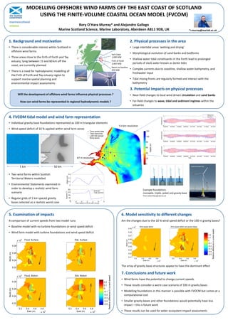
4. FVCOM tidal model and wind farm representation
• Individual gravity base foundations represented as 100 m triangular elements
• Wind speed deficit of 10 % applied within wind farm zones
• Two wind farms within Scottish
Territorial Waters modelled
• Environmental Statements examined in
order to develop a realistic wind farm
scenario
• Regular grids of 1 km spaced gravity
bases selected as a realistic worst case
5. Examination of impacts
A comparison of current speeds from two model runs:
• Baseline model with no turbine foundations or wind speed deficit
• Wind farm model with turbine foundations and wind speed deficit
7. Conclusions and future work
6. Model sensitivity to different changes
Are the changes due to the 10 % wind speed deficit or the 100 m gravity bases?
The array of gravity base structures appear to have the dominant effect
• Wind farms have the potential to change current speeds
• These results consider a worst case scenario of 100 m gravity bases
• Modelling foundations in this manner is possible with FVOCM but comes at a
computational cost
• Smaller gravity bases and other foundations would potentially have less
impact – this is future work
• These results can be used for wider ecosystem impact assessments
5 km 50 km
67 m resolution
9.4 km resolution
Example foundations:
monopile, tripile, jacket and gravity base
From www.theengineer.co.uk
www.renews.biz
marinescotland
science