
Recommended
Recommended
More Related Content
Viewers also liked
Similar to Meniscus Hyperlocal Rainfall
Similar to Meniscus Hyperlocal Rainfall (20)
Recently uploaded
Recently uploaded (20)
Meniscus Hyperlocal Rainfall
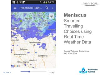
- 1. 25 June 2016 Meniscus Smarter Travelling Choices using Real Time Weather Data Annual Futures Conference 14th June 2016
- 2. 25 June 2016 Will it rain…….or won’t it????
- 3. 25 June 2016 Hyperlocal Rainfall project Funded under an InnovateUK Smart City competition Collaborative project Objective To encourage city residents to make more use of sustainable transport options – cycling and walking How? To give them accurate, journey specific, personalised rainfall predictions
- 4. 25 June 2016 Hyperlocal Rainfall - Innovations Accurate Tracking the actual rainfall that is falling Use Met Office radar data, not imagery, so we process results quicker – updates every 5 minutes Every update we create 12 x 5 minute stepped predictions for each 1km2 Use local real time wind speed and direction data to predict rainfall path ‘Ground Truthing’ radar data with local weather stations Journey specific Tie the rainfall predictions to a Journey Personalised Look to ‘predict’ the Journey they are likely to take Create customised vouchers based on previous preferences
- 5. 25 June 2016 Hyperlocal Rainfall – mobile app Android mobile app with personalisation engine Preferred Journey Discount Vouchers for weather Just launched as a Beta version so going through testing Originally planned for Peterborough area but now processing data for ½ of England Project completion March 2017 but currently ahead of schedule All delivered using the Meniscus Analytics Platform (MAP)
- 6. 25 June 2016 Built using Meniscus Analytics Platform Data pushed to MAP Information pulled using RESTful API Meniscus Analytics Platform • Apply any calculation • Deploy to millions of Things/Entities • Real Time • Generic • Scalable, flexible and lightning fast
- 7. 25 June 2016 Next Steps… Two key things 1. Looking for Smart Cities and Local Councils to partner with Originally envisaged they may buy – but now believe this is unlikely Looking for councils to help deploy this app to local residents 2. Looking for corporates interested in sponsoring Promote health and well being of employees Able to use the app for their workforce
- 8. 25 June 2016 Focus on Cleantech sector – Water and Electricity Cloud based service turning data into calculated metrics Software is developed and proven Meniscus Calculation Engine (MCE) – original proven platform Meniscus Analytics Platform (MAP) – completed in 2014 with part funding from InnovateUK Delivered via a range of dashboard solutions or via a comprehensive RESTful API Meniscus – background
- 9. 25 June 2016 • Mike Everest • Meniscus Systems Ltd Huntingdon Business Centre Blackstone Road Huntingdon PE29 6EF • T +44 1480 433714 • E meverest@meniscus.co.uk Contact Information
Editor's Notes
- Thank you for giving me the opportunity to present our Smart City application to you today My name is Mike Everest and am Managing Director of Meniscus Systems Ltd. This is a solution that we are currently working on looking at delivering smarter travelling choices for City residents by making better use of real time rainfall data – we are using other datasets but rainfall is the main one
- So the question that we are looking to help answer is this.... I want to make a journey ....so will it rain or won’t it???? This is the largest single reason that people give for not using sustainable transport options when travelling around a city. For the purpose of this particular project we are really taking about getting people to cycle and walk more
- The Project is funded under an InnovateUK collaborative Smart City competition and is delivering the project in Peterborough There are four project partners Meniscus as project lead – I will give you a bit more information about the work we do later on Loughborough Uni is leading on User Centered Design – so analysing and reviewing feedback from users to help ensure the app delivers information in a user friendly and informative manner Anglia Ruskin uni is leading on the development of a personalisation engine to help deliver information specific to each user Peterborough Environment City Trust is a local charity with access to local community groups and is helping to find user groups to test the app Peterborough City Council is a ‘silent’ partner. They are involved in the project but are not active So the objective of the project is as set out here The more important part is how we are going to deliver this – and this is by providing accurate journey specific personalised rainfall predictions So i just want to discuss these key points in a little more detail
- Accuracy Delivering accurate prediction is really important since its the key measure by which users will take up the app. We know that there are competitive products out there but we believe that we can deliver a much more accurate solution We are tracking the actual rainfall that is falling – we are not forecasting but rather predicting where actual rainfall will move We are using the actual radar data not the publicly available radar imagery. Imagery is available every 15 minutes so taking into account processing time it could be nearlly 40 minutes behind time. The actual data arrives every 5 minutes so taking into account processing we are around 10-15 minutes behind time Using the data we are processing the data at 1km2 pixels – and this may be reduced to 500m2 pixels soon. At each 5 min interval we are creating 12 predictions for each 1km2 We are using average local wind direction and speed data from a open feed weather stations around the city – these are run by the City for eductional use We are just about to apply a ground truthing model that using local rain gauges to correct the radar data to local conditions We are also looking at several other area where we can improve prediction accuracy The app will allow users to create Journeys from a sepcified Start point to an End Point. For each journey we will show the user the rainfall along the route at each 5 minute interval over the course of the Journey. The user can forward the time to see if is better to leave now or delay the start of the journey Finally we are using the personalisation engine to predict the likely journey that a user will take bringing that journey to the top of the list. We are also planning to push a range of notifications to users and one of these will be ‘discount’ vouchers – i.e. If it is going to rain we can push discount vouchers to users giving them a discount off a coffee at a local coffee shop
- We have created an Android app for residents which we are just in the process of releasing for user testing. These are some of the screen shots on the left hand side We originally planned the app to just cover the Peterborough area but we are actually running ahead of schedule and have now switched on a rainfall data set covering half of England and we are confident that it will work fine using the whole England and Wales dataset. We are expecting the whole project to complete by March 2017 All of thie is delivered using the Meniscus Analytics Platform - MAP
- So just a few words on MAP This is our Big Data real time analytics platform It is totally cloud based and also part funded under a separate InnovateUK project. Using MAP we can develop any model and then apply to that model to any raw dataset to turn it into the calculated metrics that people want. The final inforamation can then be pulled from the servers using a RESTful API Using MAP we can apply a model to an entity or thing and then we can rapidly replicate that entity thousands or millions of times
- So we are looking for two key things First we are really keen to talk to Councils and Smart Cities who may want to get the benefits of the app and can help us to promote and deploy the app to their residents Secondly we are looking for corporate partners for sponsorship where they can use the app to both promote health and well being to their employees but also are able to actively use the app for their workforce
- Finally a few words on meniscus We are a small business based in Huntingdon. We have been around since 1997 delivering a range of historic and real time web based analytics solutions to primarily the cleantech sector – we do a lot of work in the water industry – using both MAP and MCE
- Thank you once again for your time We have a stand outside if you would to chat further or please contact me using this information