Presentation GAPE Darren Shifting cultivation 29 March 2012LIWG-Laos
This document discusses shifting agriculture and livelihoods of upland communities in Laos. It describes two forms of shifting cultivation - rotational and pioneering - and provides details on the swidden calendar and inputs/outputs of swidden versus paddy land. While shifting cultivation can cause temporary deforestation, it also allows for forest regrowth. There is debate around its environmental impacts and whether it condemns rural people to poverty or provides a form of diversified agroforestry.
Climate justice and rights and thai policy on redd vtLIWG-Laos
This document discusses Thailand's policy on REDD+ (Reducing Emissions from Deforestation and Forest Degradation). It notes that Thailand submitted a Readiness Plan Idea Note in 2009 and a Readiness Preparation Proposal in 2010 to participate in the Forest Carbon Partnership Facility's REDD+ program. The document also outlines Thailand's national greenhouse gas emissions by sector from 2000 to 2010 based on national inventory reports, with the land use and forestry sector being a significant source of emissions. It stresses that REDD+ implementation in Thailand must respect climate justice and local community rights.
Presentation TABI Andreas Shifting Cultivation 29 March 2012 LIWG-Laos
This document discusses shifting cultivation landscapes in northern Laos. There is limited reliable national data on the extent and population involved in shifting cultivation. New remote sensing approaches combining medium and high resolution satellite imagery show shifting cultivation may cover 2-4.8 million hectares and involve 1-1.8 million people. Shifting cultivation landscapes tend to be more remote, impoverished, and inhabited by ethnic minority groups. Improved land use planning and coordination is needed to better integrate rotational shifting cultivation.
Adjudication of Land Occupation Right Approved PMO NLMA E564 Eng, unoff. tran...LIWG-Laos
This document outlines procedures for land adjudication in Laos, including:
1) Definitions of key terms like adjudication, land titles, and certificates.
2) Guidelines for preparing areas for systematic and sporadic (individual) adjudication, including notifying stakeholders.
3) Requirements for notification prior to adjudication, including publishing notices with details of the process, schedules, and costs.
6-10-2011 Lessons learned from the Participatory Action Research NLMALIWG-Laos
This document discusses a participatory action research project on communal land titling in Sangthong village, Lao PDR. The project aims to pilot a cooperative model between the National Land Management Authority and local authorities for communal land adjudication and registration. Participatory action research is being used as it is a learning approach that allows for social engagement, conflict avoidance, and quality control. The main activities of the project include training the research team, conducting meetings with village leaders and the district land management authority, and hosting workshops to discuss the communal land titling process and understand relevant legal documents and stakeholders. The project seeks to clearly define and grant communal land titles by finding and demarcating the traditional boundaries of communal lands using participatory
6-10-2011 Case example: Communal land titling in Sangthong district ENGLIWG-Laos
The document summarizes land use planning efforts in Sangthong District, Laos. It details how the district land management authority (DLMA) mapped village boundaries and land uses across 37 villages divided into 5 clusters. Key land types identified include agriculture, forest, wetlands and construction. The DLMA aims to formally register communal land titles for 4 villages, which requires inventorying forest resources, resolving land boundaries, and issuing temporary and then permanent land title deeds. The process provides benefits to villages for sustainably managing and utilizing their forest lands.
This document discusses shifting cultivation landscapes in northern Laos. It notes that existing data on the extent and population involved in shifting cultivation comes from case studies and anecdotes rather than reliable national statistics. New remote sensing approaches aim to better detect and monitor shifting cultivation areas over time. Preliminary analysis from 2000-2009 suggests shifting cultivation remains widespread, occupying an estimated 2-4.5 million hectares. Populations in these landscapes tend to be more remote, impoverished, and belong to ethnic minority groups. Integrating rotational shifting cultivation into village land use planning and providing online coordination platforms could help facilitate information access.
Instruction PMO NLMA 3204 Collection of Fees and ChargesLIWG-Laos
This document outlines fees and service charges collected by the Lao land management sector. It specifies the types of fees, such as for land registration and transactions, as well as the rates for these fees. Service charges are also defined for activities like land measurement and document verification. Exemptions from fees are provided for certain land conversions and entities. The document concludes by noting penalty measures for non-compliance with the fee and service charge collection rules.
This document discusses case studies from Cambodia and Indonesia on community rights and forest carbon markets. In Cambodia, a REDD+ pilot project built on existing community forest work but communities face challenges from illegal logging by the military and concessions. The project has not generated expected benefits and conflicts have emerged. In Indonesia, agreements have expanded the military's role in conservation projects concerning rights groups, and lessons from conflict areas suggest market-driven programs like the Forest Investment Program can increase human rights violations.
A2 j survey workshop for launching 29 feb 2012LIWG-Laos
The document summarizes the results of a survey on access to justice in Lao PDR. The survey had several objectives: to inform development of the Legal Sector Master Plan, build on successes to enhance access to justice, assist in prioritizing issues and target groups, and identify best methods for legal awareness activities. Key findings included that lack of legal awareness is a major obstacle, particularly for formal mechanisms; people find legal awareness activities useful but prefer official sources; and legal aid is less common outside Vientiane. The survey results can help meet the Legal Sector Master Plan goal of establishing an efficient, effective, equitable and accessible justice system.
Instruction PMO NLMA Management of State and Communal Land Eng, unoff. translLIWG-Laos
This document provides instructions on the management of state and communal land in Laos. It defines key terms like state land, communal land, and land utilization rights. It establishes a system for registering state and communal land parcels and legal documents related to land transactions. It outlines procedures for granting state land utilization rights, including criteria for eligibility and the responsibilities of different agencies in authorizing utilization rights. The overall aim is to implement laws and policies on land management in a centralized and uniform manner across the country.
REDD+ aims to reduce emissions from deforestation and forest degradation, and foster conservation and sustainable forest management. It proposes payments to developing countries to protect forests, but critics argue it could incentivize deforestation. Key concerns include the commodification of forests, risks of carbon markets, impacts on indigenous peoples' rights, and lack of addressing the true drivers of deforestation like extractive industries. Alternatives proposed include stronger land tenure, local stewardship, and reducing consumption of forest-risk commodities.
6-10-2011 Remarks on policy and background of communal land titling NLMALIWG-Laos
This document summarizes the Lao government's policies and plans regarding communal land titling. It discusses the background of communal property rights in Laos, the government's policy and objectives, and upcoming activities. The government aims to complete national land zoning plans, register land use rights across the country, and increase land revenue, in order to promote sustainable development, reduce poverty, and resolve land conflicts. Micro-level land use planning will also be important to properly allocate land uses and issue land titles at the local level.
Shifting cultivation, also known as slash and burn agriculture, is a farming method used by over 300,000 people worldwide. It involves clearing areas of forest for crops, which are grown for a few years until soil fertility declines, at which point a new area is cleared. Population densities are very low, around 1 person per square kilometer, due to the dispersed settlement pattern required with frequent field relocation. Crops grown include manioc, maize, bananas, and other fruits and vegetables. After several years of use, fields are abandoned to allow the forest and soil nutrients to recover through natural regeneration.
Slash-and-burn agriculture involves cutting and burning forests to clear land for cultivation. It is used by 200-500 million people worldwide and involves little technology. Farmers cut vegetation, allow it to dry, then burn the land to remove pests and add nutrients before planting crops. While beneficial to small farmers by providing fertile land and multiple crops, slash-and-burn causes deforestation, erosion, nutrient loss and biodiversity loss if not given time to recover between burnings. Alternatives like crop rotation and agroforestry are encouraged to prevent environmental damage from this traditional practice.
Shifting cultivation involves clearing and burning forest areas for temporary agriculture, leading to deforestation, erosion, desertification, and loss of biodiversity as forests are destroyed. However, it also benefits the environment by recycling nutrients into used land, improving sustainability, and providing organic pest management. The challenges are balancing these adverse impacts with the environmental benefits of the practice.
This document discusses different types of problem soils in India, including saline soils, sodic soils, and acid soils. Saline soils contain excess salts and affect plant growth through osmotic effects. Sodic soils have a high pH and sodium content which disperses clay and reduces permeability. Acid soils are characterized by low pH and aluminum toxicity. The document outlines methods for reclaiming each soil type, including leaching salts from saline soils, applying gypsum to sodic soils to replace sodium with calcium, and liming acid soils to raise pH. Crop selection, irrigation management, and soil amendments are also important strategies for reclaiming problem soils.
This presentation by Naw Ei Ei Min
was given at a session titled "How indigenous peoples use landscapes approaches to conserve forests: Good practices and challenges for food security and livelihoods" at the Global Landscapes Forum in Lima, Peru, on December 6, 2014.
The panel focused on the roles and contributions of indigenous women in landscape forest management. Also, the experiences from REDD+ in Asia were shared, linking it with the land use of indigenous peoples.
El documento presenta una breve introducción al constructivismo como teoría del aprendizaje. Define el constructivismo como una teoría que va de la práctica a la teoría, originada por Jean Piaget. Describe que el constructivismo se caracteriza por ser social y basarse en la percepción, y que incluye una concepción psicológica y filosófica.
Salinization is caused by irrigation which increases surface water and flooding, leading to higher salt deposits as water evaporates. Soil erosion is defined as the removal of soil by wind or water. It is caused by overgrazing, ploughing up and down hills, deforestation, and overcropping, which damage soil structure and increase runoff. Various methods like terracing, contour ploughing, and stone lines have been used worldwide to prevent soil erosion.
- The document discusses reducing emissions from deforestation and forest degradation (REDD+) and its core concepts, including: (1) REL which establishes a emissions reference level; (2) MRV which involves monitoring, reporting and verification of emissions reductions; and (3) roadmaps which lay out the steps for REDD+ implementation.
- It also addresses how REL and MRV are used to quantify emissions reductions and generate carbon credits under REDD+. Baseline emissions are established and projects must demonstrate reductions below this level through MRV to be issued tradable credits.
- Finally, it lists components that national REDD+ programs and projects should include such as safeguards, funding proposals, and phases
The document discusses REDD+ implementation in Lao PDR, focusing on the Nam Et Phou Louey National Protected Area (NEPL NPA). It notes that Lao PDR has high forest cover but also high deforestation rates, and that rural communities highly depend on forests. It outlines steps Lao PDR is taking to prepare for REDD+, and describes a partnership between WCS and the CliPAD project to implement REDD+ at NEPL NPA and another site. The feasibility study found low deforestation rates across NEPL NPA, and that incentives like participatory land use planning and conservation agreements can help engage communities in REDD+. It also notes challenges in fully implementing these incentives and the need
Presentation jannie armstrong fao 1 june 2012 food securityLIWG-Laos
This document summarizes a workshop on food security and the right to adequate food in Lao PDR. It defines food security, outlines the four pillars of food security (availability, access, utilization, stability), and provides key data on poverty, food production, and malnutrition in Lao PDR. It discusses key determinants of food security in the country including ethnicity, infrastructure, livelihoods, seasonality, and lack of social safety nets. The document also examines tensions between traditional and modern agriculture, and different livelihood opportunities. Finally, it defines the right to adequate food under international law and how this perspective differs from food security by making vulnerable groups the central concern and emphasizing participation, empowerment, and accountability.
Presentation andreas heinimann cde tabi 1 june 2012 food securityLIWG-Laos
The document summarizes initial findings on the scale and patterns of land concessions in Lao PDR based on systematic national data. Over 3,600 land deals were identified covering around 1.1 million hectares, with the majority being concessions for agriculture (140,000 hectares) and forestry (300,000 hectares). Spatial analysis found that around 15% of villages had at least one concession. Foreign direct investment deals tended to be larger in scale and located in more remote areas compared to domestic deals. While concessions were not solely located in marginal areas, some evidence indicates land deals are occurring in regions with rotational agricultural systems and could be contributing to shifts in subsistence farming to more remote locations.
This document discusses shifting cultivation landscapes in northern Laos. It notes that existing data on the extent and population involved in shifting cultivation comes from case studies and anecdotes rather than reliable national statistics. New remote sensing approaches aim to better detect and monitor shifting cultivation areas over time. Preliminary analysis from 2000-2009 suggests shifting cultivation remains widespread, with those living in these landscapes facing greater remoteness, poverty, and marginalization. Proper integration of rotational agriculture into village land use planning could help address these issues.
This document provides an overview of mapping and GIS functions in QGIS including:
1. Opening existing vector data layers, manipulating their properties, and saving projects.
2. Working with layer attribute tables to calculate geometries and fields.
3. Creating new shapefiles from GPS coordinates, selections, and by converting existing features.
4. Using analysis tools like buffer and union to examine overlaps between layers showing land use permissions, plantations, and satellite imagery.
Presentation Mekong Watch Satomi Case studies on individual land titling 29 M...LIWG-Laos
The document summarizes preliminary results from case studies on the impacts of individual land titling for swidden land. It describes the background and methods of the case studies in 5 villages. Key findings include: 1) Some powerful families have occupied large areas of land, forcing others to pay rent; 2) Practices vary between villages, with some privately occupying land before titling and others using land communally; 3) Titling has formalized existing land claims in some areas but also led to renting and disputes in others.
Foley Planting for Future Volume II Annexes June 2009LIWG-Laos
Mapping the principles and process for preparing an environmental and social Code
of Practice (CoP) for the industrial tree plantation sector in Laos (annexes).
Foley Planting for Future Volume II Annexes June 2009
Mapping cifor
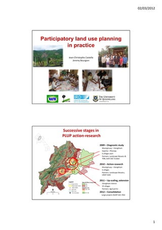
1. 02/03/2012
Participatory land use planning
in practice
Jean‐Christophe Castella
Jeremy Bourgoin
Successive stages in
PLUP action‐research
2009 – Diagnostic study
Muongmuay – Viengkham
Sopchia Phonxay
S hi – Ph
6 villages each
Partners: Landscape Mosaics &
TABI, both SDC funded
2010 – Action‐research
Muongmuay – Viengkham
6 villages
Partners: Landscape Mosaics,
URDP SIDA
URDP‐SIDA
2011 – Up‐scaling, extension
Viengkham District
25 villages
Partners: Agrisud‐EU
2012 – Consolidation
Large projects NUDP‐GIZ, IFAD
1
2. 02/03/2012
2009 PLUP Manual (MAF‐NLMA)
principles for PLUP implementation
Participation ‐ for improved legitimacy of the process outcomes
Integration ‐ scale (rationalizing land use plans across scales),
g ( g p ),
‐ knowledge (conservation‐development trade‐offs)
‐ multiple stakeholders’ perspectives
BUT lack of methodological support ‐> inappropriate on‐the‐ground practices
Lestrelin G., Bourgoin J., Bouahom B., Castella J.-C. (2011) Measuring participation: Case studies on village land-use planning in northern Lao PDR.
Applied Geography 31:950-958.
Lestrelin G., Castella J.-C., and Bourgoin J. (2012) Territorialising sustainable development: The politics of land-use planning in the Lao People’s
Democratic Republic. Journal of Contemporary Asia (in press)
ການຈັດຕັ້ງປະຕິບັດ-ສຶກສາຄົ້ນຄວ້າ ເພືອສະໜັບສະໜັບ
່
ການມີສ່ວນຮ່ວມຂອງປະຊາຊົນພາຍໃນທ້ອງຖິ່ນ
‘ຈັດກິດຈະກໍາການວາງແຜນນໍາໃຊ້ທີ່ດິນແບບມີສ່ວນຮ່ວມ’: ຈັດຕັ້ງ ແລະ ອໍານວຍຄວາມສະດວກໃນ
ການຫຼິ້ນເກມ ເພື່ອເປັນການທໍາຄວາມເຂົ້າໃຈເຖິງສັກກະຍາພາບທາງດ້ານເສດຖະກິດ ແລະ
ສງແວດລອມ ທກຽວພນເຖງການການດເຂດນາໃຊທດນ
ສິ່ງແວດລ້ອມ ທີ່ກ່ຽວພັນເຖິງການກໍານົດເຂດນໍາໃຊ້ທີ່ດນ
ິ
ແບບຈໍາລອງການມີສ່ວນຮ່ວມ 3 ມິຕ: ພາຍໃຕ້ການສະເໜີທັດສະນີຍະພາບທາງພື້ນທີ່
ິ
ແລະ ການປຶກສາຫາລື ກ່ຽວກັບຂອບເຂດຊາຍແດນ ກັບພາກສ່ວນທີ່ກຽວຂ້ອງທີ່ແຕກ
່
ຕ່າງກັນ
ສ້າງແບບຈໍາລອງໃນການເຈລະຈາຕໍ່ລອງກັນ ໂດຍການນໍາໃຊ້ຄອມພິວເຕີ້ ເພື່ອປະເມີນຜົນກະທົບ
ໃນການວາງແຜນຈັດການຄຸ້ມຄອງການນໍາໃຊ້ທີ່ດິນ ໃນລະດັບບ້ານ ແລະ ກຸ່ມບ້ານ
2
3. 02/03/2012
Village meeting
PLUP introduction to the village
Selection of the 12 members of the Village Land
Management Committee (VLMC)
g ( )
‐ Balanced sample of social classes, gender and ethnicity
Social‐economic data
Household survey
Village socio-economic data and land tenure analysis
g y
Focus groups (men and women separately)
• Village problem census
• Wood and NTFP mapping
• Wildlife management
• Population trends
3
4. 02/03/2012
PLUP Fiction role play
Eliciting PLUP Parameters
Bourgoin J. and Castella J-C. (2011) ‘PLUP Fiction’: Landscape simulation for participatory land-use planning in northern Lao PDR.
Mountain Research and Development 31(2): 78-88.
4
8. 02/03/2012
STEP 2. Village zoning
• Building a 3D model of the village landscape
• D li
Delineating village boundaries
ti ill b d i
• Negotiating the village’s future on the 3D model using
the knowledge acquired during the landscape
simulation (PLUP Fiction)
Building the 3D model
8
14. 02/03/2012
Village boundaries – GPS verification
Village zoning/planning
Engage villagers in iterative zoning negotiations
Village socio‐ Planning on P3DM
economic data in Zones
relation to land‐use
Iterations
1
Capture – camera 2
Digitize – GIS …
‐> Areas n
Cost/benefit
assessment
Final
Consensual plan
Bourgoin J, Castella J.C., Pullar D., Lestrelin G., Bouahom B. (2012) Toward a land zoning negotiation support platform: “Tips and tricks”
for participatory land use planning in Laos. Landscape and Urban Planning 104: 270– 278.
14
21. 02/03/2012
Finalizing maps
Preparing PLUP agreement
• Signed by village head, land office, agriculture & forest office,
district governor
• Description of boundaries
• Ri ht
Rights and rules
d l
• … conservation agreement?
21
22. 02/03/2012
Final village meeting
• Reporting PLUP results to villagers and neighboring villages.
Thank you for your attention
22