SlideShare a Scribd company logo
MAC Region IRWM Program

California has established a state-wide Integrated Regional Water Management (IRWM)
Planning program that promotes collaborative planning and prioritized water resource
management actions in regions throughout the state. The program’s goal is to systematically
ensure sustainable water uses, reliable water supplies, better water quality, environmental
stewardship, efficient urban development, protection of agriculture, and a stronger regional
economy. Administered by the California Department of Water Resources (DWR), the state
IRWM program encourages creation of Regional Water Management Groups (RWMG) and the
use of collaborative processes to develop integrated regional water management plans which
target regional water resource issues. DWR supports and promotes the integrated regional
planning work of RWMGs by providing funding through competitive grants.

The initial MAC IRWM planning effort was initiated as a cooperative effort by Amador Water
Agency (AWA), Calaveras County Water District (CCWD), Amador County, City of Jackson,
City of Sutter Creek, City of Plymouth, Amador Regional Sanitation Authority (ARSA) and East
Bay Municipal Utility District (EBMUD). These entities entered into a Memorandum of
Understanding (MOU) for the purposes of coordinating water resources planning and
implementation activities and formed the official MAC region RWMG, with AWA assuming the
role of region administrator for the RWMG. The initial MAC IRWM was adopted in November
2006.

In 2009 the Upper Mokelumne River Watershed Authority assumed lead agency responsibilities
with respect to the MAC Region IRWM program. In fulfilling this RWMG role UMRWA has
established two committees, the Board Advisory Committee (or BAC) and the Regional
Participants Committee (or RPC). The BAC is comprised by UMRWA directors representing
Amador water Agency, Calaveras County Water District and East Bay MUD. The RPC is
discussed under a separate link on this webpage.

What is MAC?

MAC is an acronym for Mokelumne-Amador-Calaveras. The term was coined to describe the
MAC region, one of more than fifty IRWM regions established in California under the state’s
IRWM program. The MAC region incorporates all of Amador County and sizeable portions of
Calaveras and Alpine Counties. Included within the region’s boundary are cities, water and
irrigation districts, watershed management areas, portions of groundwater basins, disadvantaged
communities, and large tracts of federally-owned lands. Figure 1 shows the MAC IRWM region.

The MAC region contains approximately 1.25 million acres (about 1,950 square miles) and is
located in the Sierra Nevada foothills, approximately 45 miles southeast of Sacramento. Situated
in a transitional zone between the San Joaquin Valley and the Sierra Nevada, the region stretches
across varied topography and microclimates. Warm, dry summers and mild winters are
predominant in the western foothills. Mild summers and cold winters characterize the
mountainous eastern region with temperatures ranging. Hot, dry summers and mild winters
prevail in the western portion of the region with summer day time highs in excess of 100
degrees.
The MAC IRWM region is home to approximately 130,000 people. About 80% of the population
lives in urban areas, although 98% of the region is considered rural. The overall population
density is 2000 people per square mile (the average for the entire region), with rural areas having
a population density of about 40 people per square mile.

The primary sources of water in the region are the Mokelumne and Calaveras River watersheds
(and to a lesser extent, the Cosumnes River watershed), with snowmelt and rainfall from the
Sierra Mountain
Range transported via the rivers and their tributaries. Although the region is famous for its
historic gold mining and recreation, current land uses also include cattle ranching, orchards,
timber, vineyards and row crops, and mining (industrial minerals, limestone, sand and gravel).

Development in the MAC Region, both urban and rural, is clustered around the major cities and
highways. Agriculture, grazing, and open spaces dominate land uses and represent a relatively
large portion of the total region land use. Other industries outside the urban setting include
mining and timber harvesting where the majority of the land cover is forest, shrub and grassland.
General land use trends in the region include significant development of rural and agricultural
areas associated with population increases in Plymouth and Sutter Creek (Amador County),
Kirkwood and Bear Valley (Alpine County), and the Rancho Calaveras and La Contenta areas
(Calaveras County). A second land use trend is a shift from grazing to viticulture and viticulture
to residential development.

FIGURE 1:

More Related Content

Similar to MAC Region IRWM Program

CALIFORNIA’S LEVEE EVALUATIONS PROGRAM
CALIFORNIA’S LEVEE EVALUATIONS PROGRAMCALIFORNIA’S LEVEE EVALUATIONS PROGRAM
CALIFORNIA’S LEVEE EVALUATIONS PROGRAMAhmad Mousa
 
CLN 1.0 Progress Report_print
CLN 1.0 Progress Report_printCLN 1.0 Progress Report_print
CLN 1.0 Progress Report_printCrystal Simons
 
Issues of coastal area in kerala
Issues of coastal area in keralaIssues of coastal area in kerala
Issues of coastal area in kerala
jositeena
 
Vertical Integration in the NAP Processes | County Government of Marsabit
Vertical Integration in the NAP Processes | County Government of MarsabitVertical Integration in the NAP Processes | County Government of Marsabit
Vertical Integration in the NAP Processes | County Government of Marsabit
NAP Global Network
 
Where Land and Water Meet - Mike Swezy from Marin Municipal Water District
Where Land and Water Meet - Mike Swezy from Marin Municipal Water DistrictWhere Land and Water Meet - Mike Swezy from Marin Municipal Water District
Where Land and Water Meet - Mike Swezy from Marin Municipal Water District
OpenSpaceCouncil
 
Where Land and Water Meet - Mike Swezy from Marin Municipal Water District
Where Land and Water Meet - Mike Swezy from Marin Municipal Water DistrictWhere Land and Water Meet - Mike Swezy from Marin Municipal Water District
Where Land and Water Meet - Mike Swezy from Marin Municipal Water District
Annie Burke
 
Tagum-Workshop-Presentation-02_Tagum-City-LCCAP.pdf
Tagum-Workshop-Presentation-02_Tagum-City-LCCAP.pdfTagum-Workshop-Presentation-02_Tagum-City-LCCAP.pdf
Tagum-Workshop-Presentation-02_Tagum-City-LCCAP.pdf
SumWhosin
 
Louisiana vanishing coastal wetlands 8 31-10
Louisiana vanishing coastal wetlands 8 31-10Louisiana vanishing coastal wetlands 8 31-10
Louisiana vanishing coastal wetlands 8 31-10
Brian Shealy
 
Inalí River and Tapacalí River Sub-watersheds
Inalí River and Tapacalí River Sub-watershedsInalí River and Tapacalí River Sub-watersheds
Inalí River and Tapacalí River Sub-watersheds
CARE Nicaragua
 
Flood and Watershed Management: Dealing with Natural Disasters
Flood and Watershed Management: Dealing with Natural DisastersFlood and Watershed Management: Dealing with Natural Disasters
Flood and Watershed Management: Dealing with Natural Disasters
2020resilience
 
Strategic Action Program for the Bermejo River Binational Basin: Argentina- B...
Strategic Action Program for the Bermejo River Binational Basin: Argentina- B...Strategic Action Program for the Bermejo River Binational Basin: Argentina- B...
Strategic Action Program for the Bermejo River Binational Basin: Argentina- B...
Iwl Pcu
 
Ridge-to-Reef Approach in Planning.pdf
Ridge-to-Reef Approach in Planning.pdfRidge-to-Reef Approach in Planning.pdf
Ridge-to-Reef Approach in Planning.pdf
joannagrande
 
Vargas et al 2010 mtn. forum bull.
Vargas et al 2010 mtn. forum bull.Vargas et al 2010 mtn. forum bull.
Vargas et al 2010 mtn. forum bull.Invan Perez
 
The Case of the Senegal River Basin (Niasse, Madiodio)
The Case of the Senegal River Basin (Niasse, Madiodio)The Case of the Senegal River Basin (Niasse, Madiodio)
The Case of the Senegal River Basin (Niasse, Madiodio)
Iwl Pcu
 
The Case of the Senegal River Basin (Niasse, Madiodio)
The Case of the Senegal River Basin (Niasse, Madiodio)The Case of the Senegal River Basin (Niasse, Madiodio)
The Case of the Senegal River Basin (Niasse, Madiodio)
Iwl Pcu
 
The Case of the Senegal River Basin (Niasse, Madiodio)
The Case of the Senegal River Basin (Niasse, Madiodio)The Case of the Senegal River Basin (Niasse, Madiodio)
The Case of the Senegal River Basin (Niasse, Madiodio)
Iwl Pcu
 
2014 SONR - Potomac Conservancy
2014 SONR - Potomac Conservancy2014 SONR - Potomac Conservancy
2014 SONR - Potomac ConservancyMelissa Diemand
 
New mexico association of conservation districts
New mexico association of conservation districtsNew mexico association of conservation districts
New mexico association of conservation districts
Soil and Water Conservation Society
 
Coastal zone management in India
Coastal zone management in IndiaCoastal zone management in India
Coastal zone management in India
aiswaryas84
 

Similar to MAC Region IRWM Program (20)

CALIFORNIA’S LEVEE EVALUATIONS PROGRAM
CALIFORNIA’S LEVEE EVALUATIONS PROGRAMCALIFORNIA’S LEVEE EVALUATIONS PROGRAM
CALIFORNIA’S LEVEE EVALUATIONS PROGRAM
 
CLN 1.0 Progress Report_print
CLN 1.0 Progress Report_printCLN 1.0 Progress Report_print
CLN 1.0 Progress Report_print
 
Issues of coastal area in kerala
Issues of coastal area in keralaIssues of coastal area in kerala
Issues of coastal area in kerala
 
Vertical Integration in the NAP Processes | County Government of Marsabit
Vertical Integration in the NAP Processes | County Government of MarsabitVertical Integration in the NAP Processes | County Government of Marsabit
Vertical Integration in the NAP Processes | County Government of Marsabit
 
Where Land and Water Meet - Mike Swezy from Marin Municipal Water District
Where Land and Water Meet - Mike Swezy from Marin Municipal Water DistrictWhere Land and Water Meet - Mike Swezy from Marin Municipal Water District
Where Land and Water Meet - Mike Swezy from Marin Municipal Water District
 
Where Land and Water Meet - Mike Swezy from Marin Municipal Water District
Where Land and Water Meet - Mike Swezy from Marin Municipal Water DistrictWhere Land and Water Meet - Mike Swezy from Marin Municipal Water District
Where Land and Water Meet - Mike Swezy from Marin Municipal Water District
 
Tagum-Workshop-Presentation-02_Tagum-City-LCCAP.pdf
Tagum-Workshop-Presentation-02_Tagum-City-LCCAP.pdfTagum-Workshop-Presentation-02_Tagum-City-LCCAP.pdf
Tagum-Workshop-Presentation-02_Tagum-City-LCCAP.pdf
 
Louisiana vanishing coastal wetlands 8 31-10
Louisiana vanishing coastal wetlands 8 31-10Louisiana vanishing coastal wetlands 8 31-10
Louisiana vanishing coastal wetlands 8 31-10
 
Inalí River and Tapacalí River Sub-watersheds
Inalí River and Tapacalí River Sub-watershedsInalí River and Tapacalí River Sub-watersheds
Inalí River and Tapacalí River Sub-watersheds
 
Flood and Watershed Management: Dealing with Natural Disasters
Flood and Watershed Management: Dealing with Natural DisastersFlood and Watershed Management: Dealing with Natural Disasters
Flood and Watershed Management: Dealing with Natural Disasters
 
Strategic Action Program for the Bermejo River Binational Basin: Argentina- B...
Strategic Action Program for the Bermejo River Binational Basin: Argentina- B...Strategic Action Program for the Bermejo River Binational Basin: Argentina- B...
Strategic Action Program for the Bermejo River Binational Basin: Argentina- B...
 
Ridge-to-Reef Approach in Planning.pdf
Ridge-to-Reef Approach in Planning.pdfRidge-to-Reef Approach in Planning.pdf
Ridge-to-Reef Approach in Planning.pdf
 
Vargas et al 2010 mtn. forum bull.
Vargas et al 2010 mtn. forum bull.Vargas et al 2010 mtn. forum bull.
Vargas et al 2010 mtn. forum bull.
 
The Case of the Senegal River Basin (Niasse, Madiodio)
The Case of the Senegal River Basin (Niasse, Madiodio)The Case of the Senegal River Basin (Niasse, Madiodio)
The Case of the Senegal River Basin (Niasse, Madiodio)
 
The Case of the Senegal River Basin (Niasse, Madiodio)
The Case of the Senegal River Basin (Niasse, Madiodio)The Case of the Senegal River Basin (Niasse, Madiodio)
The Case of the Senegal River Basin (Niasse, Madiodio)
 
The Case of the Senegal River Basin (Niasse, Madiodio)
The Case of the Senegal River Basin (Niasse, Madiodio)The Case of the Senegal River Basin (Niasse, Madiodio)
The Case of the Senegal River Basin (Niasse, Madiodio)
 
2014 SONR - Potomac Conservancy
2014 SONR - Potomac Conservancy2014 SONR - Potomac Conservancy
2014 SONR - Potomac Conservancy
 
New mexico association of conservation districts
New mexico association of conservation districtsNew mexico association of conservation districts
New mexico association of conservation districts
 
Coastal zone management in India
Coastal zone management in IndiaCoastal zone management in India
Coastal zone management in India
 
Australia china acedp mdba breifing final
Australia china acedp mdba breifing finalAustralia china acedp mdba breifing final
Australia china acedp mdba breifing final
 

MAC Region IRWM Program

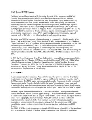
  • 1. MAC Region IRWM Program California has established a state-wide Integrated Regional Water Management (IRWM) Planning program that promotes collaborative planning and prioritized water resource management actions in regions throughout the state. The program’s goal is to systematically ensure sustainable water uses, reliable water supplies, better water quality, environmental stewardship, efficient urban development, protection of agriculture, and a stronger regional economy. Administered by the California Department of Water Resources (DWR), the state IRWM program encourages creation of Regional Water Management Groups (RWMG) and the use of collaborative processes to develop integrated regional water management plans which target regional water resource issues. DWR supports and promotes the integrated regional planning work of RWMGs by providing funding through competitive grants. The initial MAC IRWM planning effort was initiated as a cooperative effort by Amador Water Agency (AWA), Calaveras County Water District (CCWD), Amador County, City of Jackson, City of Sutter Creek, City of Plymouth, Amador Regional Sanitation Authority (ARSA) and East Bay Municipal Utility District (EBMUD). These entities entered into a Memorandum of Understanding (MOU) for the purposes of coordinating water resources planning and implementation activities and formed the official MAC region RWMG, with AWA assuming the role of region administrator for the RWMG. The initial MAC IRWM was adopted in November 2006. In 2009 the Upper Mokelumne River Watershed Authority assumed lead agency responsibilities with respect to the MAC Region IRWM program. In fulfilling this RWMG role UMRWA has established two committees, the Board Advisory Committee (or BAC) and the Regional Participants Committee (or RPC). The BAC is comprised by UMRWA directors representing Amador water Agency, Calaveras County Water District and East Bay MUD. The RPC is discussed under a separate link on this webpage. What is MAC? MAC is an acronym for Mokelumne-Amador-Calaveras. The term was coined to describe the MAC region, one of more than fifty IRWM regions established in California under the state’s IRWM program. The MAC region incorporates all of Amador County and sizeable portions of Calaveras and Alpine Counties. Included within the region’s boundary are cities, water and irrigation districts, watershed management areas, portions of groundwater basins, disadvantaged communities, and large tracts of federally-owned lands. Figure 1 shows the MAC IRWM region. The MAC region contains approximately 1.25 million acres (about 1,950 square miles) and is located in the Sierra Nevada foothills, approximately 45 miles southeast of Sacramento. Situated in a transitional zone between the San Joaquin Valley and the Sierra Nevada, the region stretches across varied topography and microclimates. Warm, dry summers and mild winters are predominant in the western foothills. Mild summers and cold winters characterize the mountainous eastern region with temperatures ranging. Hot, dry summers and mild winters prevail in the western portion of the region with summer day time highs in excess of 100 degrees. The MAC IRWM region is home to approximately 130,000 people. About 80% of the population lives in urban areas, although 98% of the region is considered rural. The overall population
  • 2. density is 2000 people per square mile (the average for the entire region), with rural areas having a population density of about 40 people per square mile. The primary sources of water in the region are the Mokelumne and Calaveras River watersheds (and to a lesser extent, the Cosumnes River watershed), with snowmelt and rainfall from the Sierra Mountain Range transported via the rivers and their tributaries. Although the region is famous for its historic gold mining and recreation, current land uses also include cattle ranching, orchards, timber, vineyards and row crops, and mining (industrial minerals, limestone, sand and gravel). Development in the MAC Region, both urban and rural, is clustered around the major cities and highways. Agriculture, grazing, and open spaces dominate land uses and represent a relatively large portion of the total region land use. Other industries outside the urban setting include mining and timber harvesting where the majority of the land cover is forest, shrub and grassland. General land use trends in the region include significant development of rural and agricultural areas associated with population increases in Plymouth and Sutter Creek (Amador County), Kirkwood and Bear Valley (Alpine County), and the Rancho Calaveras and La Contenta areas (Calaveras County). A second land use trend is a shift from grazing to viticulture and viticulture to residential development. FIGURE 1: