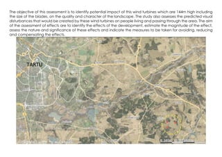
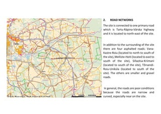
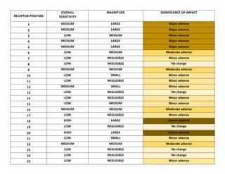
Landscape and visual impact assessment of Windfarms in Vorukula area , outskirts of Tartu. The study was conducted based on google images, site visits, map analysis, and estonian maamet website.
The document summarizes an environmental impact assessment of the Jamuna Bridge project in Bangladesh. Key points:
- The project involved constructing a 5.63km long road-rail-power bridge over the Jamuna River, along with approach roads and infrastructure.
- Potential environmental impacts identified included loss of fisheries habitat, disruption of wildlife, erosion, drainage issues, and flooding impacts.
- The assessment evaluated these impacts and proposed mitigation measures like constructing fish hatcheries, managing erosion, ensuring adequate drainage, and avoiding construction perpendicular to flood plains.
- Public consultation and environmental monitoring were recommended to minimize impacts and ensure a sustainable project.
At MTB we have designed various deposit accounts to service all your different needs. From a straight forward Savings account to Fixed Deposits, we strive to give you the best value for your money. Our accounts enable you to priorities between flexibility, highest interest yield and convenience. So the next time you are shopping for the competitive interest yield or greatest convenience for your hard earned savings, come to us for the answer!
Deposit Products
-Regular Savings Account
-MTB Senior
-MTB Inspire
-MTB Ruby
-MTB Graduate
-MTB Junior
-MTB Shanchay
-MTB Care
-Current Account
The document summarizes the evolution of the banking system in India. It describes the old banking system from 1786 to 1969 which involved manual documentation and few services. It then discusses the nationalization of banks from 1969 to 1991. Finally, it outlines the new banking system post-1991 reforms involving increased technology usage through tools like core banking solutions, ATMs, and online services that have improved customer experience but also introduced new risks like hacking and phishing.
This document provides an overview of the banking system in India. It defines banking and outlines the key laws and institutions that govern banking operations, including the Reserve Bank of India Act and the Banking Regulation Act. It describes the structure of banks in India, categorizing them as commercial banks, cooperative banks, and development banks. It provides details on the various types of commercial banks, cooperative banks, and development banks in India. It also summarizes the major functions and roles of the Reserve Bank of India in regulating the banking system.
The document summarizes a study of invasive plant species found in the Alepu Sand Dunes and marshes along the Bulgarian Black Sea coast. Twelve alien invasive species and four native invasive species were recorded in the area. The most widespread alien species is False indigo (Amorpha fruticosa), while Common reed (Phragmites australis) is the dominant native invasive species. The main routes for the spread of invasive species are proximity to a hotel complex where some species are cultivated, a connecting canal between lakes and dunes, and an adjacent coastal road used by vehicles carrying seeds. The study aims to assess threats posed by invasive species to protected coastal habitats in the area.
The document provides information on several architectural projects including a hotel, apartment, housing prototype, play school, and office/residence. It includes pages from each project covering the year, location, contributions, objectives, ideas, challenges, and briefs. It also includes technical drawings such as site plans, floor plans, sections and elevations. The second half of the document focuses on a site analysis and concept development for redesigning density housing in Nerul, Mumbai. It outlines the objective, idea, challenges and brief for this project and includes diagrams showing the zoning and programming of spaces.
Contents:
Importance of wetlands of Pakistan in the national and international context.
Types of wetlands in Pakistan with respect to area.
Most significant wetlands of Pakistan,
Four major wetland complexes /demonstration sites of Pakistan categorized under WWF-Pakistan Wetland Program (PWP).
Nineteen Internationally recognized Ramsar sites of Pakistan
The document provides site analysis information for a proposed modern museum and science center project located in Delhi, India. It includes details on the 23,750 sqm site such as location, surrounding features, connectivity to transportation and other attractions. Climate data is presented including temperature graphs, wind patterns, and precipitation. The soil type is described as derivative of Yamuna flood plain alluvium. A SWOT analysis identifies strengths such as connectivity and theme, weaknesses such as one-way traffic, and opportunities such as showcasing sustainability through design.
1) The document summarizes a field trip report on the Margalla Hills region, describing 5 stops that examined the local geology.
2) At the stops, the author observed rolling hill topography formed by stream erosion, remnants of the Indus River consisting of sand and mud layers, and outcrops of the Ghandghar Range extension and Muree Formation displaying various rock types and dips.
3) The final stop examined Margalla Hills limestone, identifying its lithology, fossils, age, and stratigraphic contacts.
The document discusses several wildlife sanctuaries in Pakistan. It provides details about the Nara Desert Wildlife Sanctuary including its location in Sindh province, annual rainfall amounts, and popular species like the endangered mugger crocodile. It then discusses the boundaries and biodiversity found at the Nara sanctuary. The document also summarizes information about the Rann of Kutch Wildlife Sanctuary, Sukkur and Guddu Barrage Dolphin Reserve, and Lake Haleji Wildlife Sanctuary, noting location, area, and key species at each location.
The document discusses 4 wildlife sanctuaries in Pakistan:
1. Nara Desert Wildlife Sanctuary which protects endangered mugger crocodiles and other animals in Sindh province.
2. Rann of Kutch Wildlife Sanctuary, the largest Ramsar site in Sindh, known for breeding flamingos and migratory birds.
3. Sukkur and Guddu Barrage Dolphin Reserve on the Indus River, home to the endangered Indus River dolphin.
4. Lake Haleji Wildlife Sanctuary, an important wintering site for migratory waterfowl and breeding site for egrets and herons in Thatta, Sindh.
The document summarizes the Incense Route and Desert Cities World Heritage Site in Israel. The route stretched from Oman and Yemen through Jordan and the Negev desert to the port of Gaza, transporting frankincense and other valuable spices. Along the route were remnants from the Nabataean, Roman, and Byzantine periods including cities, fortresses, caravanserais, temples, and milestones. The document outlines the archaeological sites along the route as well as management by Israel's Nature and Parks Authority to conserve and promote the area for sustainable tourism.
The document provides details about Vishnu Reddy's architectural works and experiences. It includes projects like the Rim Chair made from bicycle rims, the Cocoon treehouse concept, the Samskriti urban development plan, the Brahmavara town plan, a winery design called Wine & Leisure, internships at Infosys and Embassy Techzone, and a resort design in Havelock Island. It also provides floor plans and diagrams for some of the projects.
This document discusses wetlands in Pakistan. It begins by defining wetlands and describing different types, including natural wetlands like rivers and marshes, and man-made wetlands like ponds and fish farms. It then discusses four major wetland complexes in Pakistan and provides details on several important wetlands. The document also addresses threats to wetlands from degradation and loss, and provides suggestions for sustainable management and conservation.
This document analyzes the conservation status of wildlife habitats in Shwebo and Kanbalu Districts in Myanmar. It finds that wildlife habitats have greatly contracted due to expanding human activities like agriculture. Using GIS and satellite imagery, it evaluates the conservation status of 31 forest reserves based on habitat loss, size, and protection level. Most reserves show habitat loss and fragmentation. A few northern reserves may still persist for 10-15 years without further protection measures. Overall, the habitats require expanded protected areas and stronger enforcement of laws to prevent further degradation.
Ecological Study Along the Highlands Highway in Papua New GuineaIJAEMSJORNAL
This ecological survey carried out along the Highlands Highway (71 locations-bridges) between Erap Bridge in Morobe Province to Whagi Bridge, Western Highlands Province. Data and information collection involved physical site observations and informant interviews. The survey used the capture-release method for insects, invertebrates, fish, and plankton; flyover counts were used for birds and informant interviews for mammals and other animals of interest. Terrestrial ecosystem: Common fauna included invertebrates such as Eurema hecabe, Danaus plexippus, Plutella xylostella, and other types of butterflies, Anisoptera, Apis cerena, and black ants (Fomicidae). Vertebrates such as sparrows (Passeridae), willy wagtail (Rhipidura leucophrys), eagle (Hieraaetus weiskei), kingfisher (Alcedinidae), mountain cuscus (Phalanger carmelitae), tree kangaroo (Dendrolagus goodfellowi) and Princess Stephanie’s Astrapia (Astrapia. Stephaniae). Flora across the highlands province commonly appeared bamboo, casuarina oligodon (she-oak), Ficus dammaropsis, coffee, elephant grass (Pennisetum purpureum), cow grass (Axonopus compressus), rain tree (Samanea saman), Piper adancum and banana. In contrast, common and significant flora along plain region included casuarina, pine, leucaena, bamboo, and other anthropogenic grasses, Piper adancum, sunflower (Helianthus annuus), Northofagus grandis, and Ficus. Aquatic ecosystem: Aquatic fauna along the highlands region included carp (Cyprinidae), tilapia (Oreochromis mossambica), juvenile fish, freshwater prawns (Palaemonidae), trout (Oncorhynchus mykiss), and catfish (Arius spp) while aquatic fauna of coastal province comprised of invertebrates like pond skaters, water beetle and tadpoles and invertebrates such as rainbow trout and tilapia. Aquatic flora was limited to green algae at a few locations in the highlands provinces where the water was stagnant or had human impacts, but it was primarily green and brown algae in the plain area. We also found Dendrolagus goodfellowii as an endangered species, while Phalanger carmelitae, Astrapia stephaniae, and Northofagus grandis are endemic but classified as the least concern. The findings indicated modification of habitats throughout the Highlands Highway. The absence of native and endemic species was also noted in most of the locations. Only six sites revealed some primary and secondary forests and vegetation.
Benefits of Wetland and Its Well -being Supports: A Review on Behula Wetland ...Susanta Mahato
The document summarizes information about the Behula Wetland located in Malda District, West Bengal, India. It describes the wetland's location, land uses over time (1975 vs. 2014), biological characteristics, and how local communities utilize the wetland's resources. The wetland provides important ecosystem services like water supply, fishing, agriculture, and habitat. However, it also faces threats like sediment deposition from human activities that are degrading the wetland over time.
The document summarizes the existing visual character of Ulster County, the Town of Wawarsing, and the hamlet of Cragsmoor in the Shawangunk Ridge area. Key features include the Catskill and Shawangunk mountains, Rondout Creek, Wallkill River, and five lakes including Lake Maratanza. Cragsmoor is characterized by its position atop the Shawangunk Ridge and geological features like Sam's Point and Bear Hill, which provide scenic views. The document then analyzes potential visual impacts of the proposed Mahamudra Buddhist Hermitage development from five viewpoints, finding minimal impacts from Bear Hill, Cragsmoor Road, and Old Inn Road due to setbacks and existing
This document discusses the design of a cultural haven project in Titiwangsa, Kuala Lumpur. It includes a list of group members and lecturers for the project. It then discusses the existing culture in Titiwangsa, including traditional Malay architecture and park activities. It outlines the proposed design for the cultural haven, including residential zones, institutional areas with cultural buildings, and considerations for pedestrian and vehicular access. Activities and programs are proposed to help sustain traditional Malaysian culture and prevent it from fading due to modernization trends.
Architecture Design Project Studio VI Project 1ABryan Yeoh
This document discusses the design of a cultural haven project in Titiwangsa, Kuala Lumpur. It includes a list of group members and lecturers for the project. It then discusses the existing culture in Titiwangsa, including traditional Malay architecture and park activities. It outlines the proposed design for the cultural haven, including residential zones, institutional areas with cultural buildings, and considerations for pedestrian and vehicular access. Activities and programs are proposed to help sustain traditional Malaysian culture and prevent it from fading away due to modernization trends.
This document provides an overview of Bundoran Farm, a 2,300 acre property in Albemarle County, Virginia. The farm contains productive pastureland and orchards, mature forests, streams, ponds, and historic buildings. It has been carefully stewarded for decades to preserve the landscape and habitat. The vision for the property is to create a preservation community with limited residential development that maintains the working farm and protects environmental and agricultural resources through conservation easements.
This document provides a brief history of Bundoran Farm, a 2,300 acre property in Albemarle County, Virginia. It describes how the land was likely cultivated by the indigenous Monacan people prior to European settlement. Early settlers grew tobacco but lacked understanding of sustainable farming practices. The land is now ideal for apple orchards and pasturelands. Bundoran Farm has been carefully stewarded for decades through sustainable management of forests, pastures, and orchards.
This document provides an overview of Bundoran Farm, a 2,300 acre property in Albemarle County, Virginia. The farm contains productive pastureland and orchards, mature forests, streams, ponds, and historic buildings. The property has been carefully stewarded for decades through sustainable agricultural and forestry practices. The document discusses plans to establish a new type of rural community on the farm that balances limited residential development with long-term protection of the majority of the farm's agricultural and environmental resources through conservation easements.
The document summarizes a study of landslides that occurred in Khaptad area, Achham district of Nepal in August 2006, causing deaths, injuries, and damage to property. A field study was conducted to investigate the geological conditions, identify the causes of the disaster, and create a landslide hazard zonation map. The study found that excessive rainfall, land use practices, steep slopes, and toe cutting were key contributing factors. A hazard map was produced showing 39% of the area is high risk, 21% moderate risk, and 40% low risk. It is recommended to relocate settlements to safer areas due to continued landslide threats.
Similar to Landscape and visual impact assessment (20)
RoHS stands for Restriction of Hazardous Substances, which is also known as t...vijaykumar292010
RoHS stands for Restriction of Hazardous Substances, which is also known as the Directive 2002/95/EC. It includes the restrictions for the use of certain hazardous substances in electrical and electronic equipment. RoHS is a WEEE (Waste of Electrical and Electronic Equipment).
Evolving Lifecycles with High Resolution Site Characterization (HRSC) and 3-D...Joshua Orris
The incorporation of a 3DCSM and completion of HRSC provided a tool for enhanced, data-driven, decisions to support a change in remediation closure strategies. Currently, an approved pilot study has been obtained to shut-down the remediation systems (ISCO, P&T) and conduct a hydraulic study under non-pumping conditions. A separate micro-biological bench scale treatability study was competed that yielded positive results for an emerging innovative technology. As a result, a field pilot study has commenced with results expected in nine-twelve months. With the results of the hydraulic study, field pilot studies and an updated risk assessment leading site monitoring optimization cost lifecycle savings upwards of $15MM towards an alternatively evolved best available technology remediation closure strategy.
Improving the viability of probiotics by encapsulation methods for developmen...Open Access Research Paper
The popularity of functional foods among scientists and common people has been increasing day by day. Awareness and modernization make the consumer think better regarding food and nutrition. Now a day’s individual knows very well about the relation between food consumption and disease prevalence. Humans have a diversity of microbes in the gut that together form the gut microflora. Probiotics are the health-promoting live microbial cells improve host health through gut and brain connection and fighting against harmful bacteria. Bifidobacterium and Lactobacillus are the two bacterial genera which are considered to be probiotic. These good bacteria are facing challenges of viability. There are so many factors such as sensitivity to heat, pH, acidity, osmotic effect, mechanical shear, chemical components, freezing and storage time as well which affects the viability of probiotics in the dairy food matrix as well as in the gut. Multiple efforts have been done in the past and ongoing in present for these beneficial microbial population stability until their destination in the gut. One of a useful technique known as microencapsulation makes the probiotic effective in the diversified conditions and maintain these microbe’s community to the optimum level for achieving targeted benefits. Dairy products are found to be an ideal vehicle for probiotic incorporation. It has been seen that the encapsulated microbial cells show higher viability than the free cells in different processing and storage conditions as well as against bile salts in the gut. They make the food functional when incorporated, without affecting the product sensory characteristics.
Optimizing Post Remediation Groundwater Performance with Enhanced Microbiolog...Joshua Orris
Results of geophysics and pneumatic injection pilot tests during 2003 – 2007 yielded significant positive results for injection delivery design and contaminant mass treatment, resulting in permanent shut-down of an existing groundwater Pump & Treat system.
Accessible source areas were subsequently removed (2011) by soil excavation and treated with the placement of Emulsified Vegetable Oil EVO and zero-valent iron ZVI to accelerate treatment of impacted groundwater in overburden and weathered fractured bedrock. Post pilot test and post remediation groundwater monitoring has included analyses of CVOCs, organic fatty acids, dissolved gases and QuantArray® -Chlor to quantify key microorganisms (e.g., Dehalococcoides, Dehalobacter, etc.) and functional genes (e.g., vinyl chloride reductase, methane monooxygenase, etc.) to assess potential for reductive dechlorination and aerobic cometabolism of CVOCs.
In 2022, the first commercial application of MetaArray™ was performed at the site. MetaArray™ utilizes statistical analysis, such as principal component analysis and multivariate analysis to provide evidence that reductive dechlorination is active or even that it is slowing. This creates actionable data allowing users to save money by making important site management decisions earlier.
The results of the MetaArray™ analysis’ support vector machine (SVM) identified groundwater monitoring wells with a 80% confidence that were characterized as either Limited for Reductive Decholorination or had a High Reductive Reduction Dechlorination potential. The results of MetaArray™ will be used to further optimize the site’s post remediation monitoring program for monitored natural attenuation.
Kinetic studies on malachite green dye adsorption from aqueous solutions by A...Open Access Research Paper
Water polluted by dyestuffs compounds is a global threat to health and the environment; accordingly, we prepared a green novel sorbent chemical and Physical system from an algae, chitosan and chitosan nanoparticle and impregnated with algae with chitosan nanocomposite for the sorption of Malachite green dye from water. The algae with chitosan nanocomposite by a simple method and used as a recyclable and effective adsorbent for the removal of malachite green dye from aqueous solutions. Algae, chitosan, chitosan nanoparticle and algae with chitosan nanocomposite were characterized using different physicochemical methods. The functional groups and chemical compounds found in algae, chitosan, chitosan algae, chitosan nanoparticle, and chitosan nanoparticle with algae were identified using FTIR, SEM, and TGADTA/DTG techniques. The optimal adsorption conditions, different dosages, pH and Temperature the amount of algae with chitosan nanocomposite were determined. At optimized conditions and the batch equilibrium studies more than 99% of the dye was removed. The adsorption process data matched well kinetics showed that the reaction order for dye varied with pseudo-first order and pseudo-second order. Furthermore, the maximum adsorption capacity of the algae with chitosan nanocomposite toward malachite green dye reached as high as 15.5mg/g, respectively. Finally, multiple times reusing of algae with chitosan nanocomposite and removing dye from a real wastewater has made it a promising and attractive option for further practical applications.
Kinetic studies on malachite green dye adsorption from aqueous solutions by A...
Landscape and visual impact assessment
1. Presented by: BHAVNA MISHRA
Department of Landscape Architecture, Estonian University of Life sciences
LANDSCAPE AND VISUAL IMPACT ASSESSMENT OF PROPOSED WIND TURBINES AT VORUKULA, ESTONIA
2. The objective of this assessment is to identify potential impact of this wind turbines which are 144m high including
the size of the blades, on the quality and character of the landscape. The study also assesses the predicted visual
disturbances that would be created by these wind turbines on people living and passing through the area. The aim
of the assessment of effects are to identify the effects of the development, estimate the magnitude of the effect,
assess the nature and significance of these effects and indicate the measures to be taken for avoiding, reducing
and compensating the effects.
TARTU
4. Extent of the area: The site at Vorukula and the areas covered within 10 km radius.
2 KM 5KM 10KM
5. STUDY OF SOIL CONDITION, ROAD NETWORKS, SETTLEMENT PATTERN, NATURE PROTECTED AREAS, FOREST
COVER, HYDROLOGY, CULTURAL HERITAGE AND PROTECTED AREAS TO DEVELOP THE LANDSCAPE CHARACTER
TYPES
1. SOIL CONDITION
The proposed wind farm area
represented mainly 5 different soil types:
1) LP- pseudopodzolic soils, 2)LPG-
pseudopodzolic gley-soils, 3)LPg- gleyed
pseudopodzolic soils, 4) GI- eluviated
gley-soils AND 5) M"'- deep swamp
soil
In view of soil types the
area is too damp and
soil is not good quality,
so area is not suitable
for cultivation. So, the
site is suitable for wind
farm.
6. 2. ROAD NETWORKS
The site is connected to one primary road
which is Tartu-Räpina-Värska highway
and it is located to north-east of the site.
In addition to the surrounding of the site
there are four asphalted roads: Vana-
Kastre-Roiu (located to north to south of
the site), Melliste-Heiti (located to east to
south of the site), Sillaotsa-Kriimani
(located to south of the site), Tõrvandi-
Roiu-Uniküla (located to south of the
site). The others are smaller and gravel
roads.
In general, the roads are poor conditions
because the roads are narrow and
curved, especially near on the site.
7. 3. SETTLEMENT PATTERN
The proposed wind farm is located in
Mäksa Parish, Võruküla village. Võruküla
village settlement is concentrated to
northwest of the site. Võruküla village
population is 47 inhabitant (2013 year
data).
Settlement around the site is distributed,
so the settlement pattern is not
clustered.
8. 4. NATURE PROTECTED AREAS
Within 2 kms, there are not so many
important nature protection and Natura
2000 areas. The nearest nature protection
areas are approximately 2-4 kilometers
away: Age oru special conservation area
(located to southwest of the site), lake
Lavatsi special conservation area (located
to southeast of the site). Kaagvere manor
park (located to north of the site).
5. FOREST COVER
In this map we can also see the forest
coverage. Near to the study area is a lot of
forest area, especially to west and south of
the site.
9. 6. THE WATER BODIES
The proposed wind farm is surrounded
with different water bodies: lakes, rivers
and streams. The nearest (~ 2 km) water
body is lake „Kaikjärv“, which is located to
east of the site. The biggest lakes are
„Poka“ and „Lavatsi“, which are located
also to east and approximately 2,5
kilometres away study area. Lake Lavatsi
has special conservation area, so it is
protected. Other water bodies located
more than 3 kilometers away study
area:1) lakes: Melliste, Kaanjärv,
Kriimani, Kitseküla, Roiu, Tammejärv,
Agali, Kurepalu artificial lake, 2)rivers:
Emajõgi, Mõra, Luutsna, 3)streams:
Melliste.
10. 7. CULTURAL HERITAGE PROTECTED
AREAS
The nearest cultural heritage area is
ohverdamiskoht "Kiigeoru hiiesalu".
Cultural heritage areas away from the site:
Ohvriallikas "Silmaläte". Ohvriallikas
"Põrguvaluläte". Linnus "Lingutusmägi".
Kivikalme "Vareslepik". Vana-Kastre
linnuse territoorium, 13-16. saj. Kaagvere
manor park buildings (Kaagvere manor
park, Mõisaase, Kaagvere mõisa kuivati,
Kaagvere mõisa valitsejamaja, Kaagvere
manor basement)
11. H
Establishment of Landscape Character types according to the site survey and Map observations.
LANDSCAPE CHARACTER AREAS
A Tartu urban and suburban character
B Oblong area of arable land and forest patches growth and industrial land use.
C Emajogi flood regime and open arable landscape
D Rolling uplands of open arable land with fragmented dense forest patches
E Rolling uplands with dense forest and no cultivated plots
F Drained flat mosaic and managed forest strip
G Uninhabited lake regime bog landscape
H Emajoe river landscape
C
H
E
H
12. H
Landscape Sensitivity, Magnitude and Significance of impact based on the Landscape Characters areas.
SENSITIVITY MAGNITUDE SIGNIFICANCE OF IMPACT
A HIGH NEGLIGIBLE MINOR
B MEDIUM MEDIUM MODERATE
C HIGH MEDIUM-SMALL MAJOR
D MEDIUM LARGE SEVERE
E MEDIUM MEDIUM-SMALL MINOR
F MEDIUM NEGLIGIBLE MINOR
G HIGH NEGLIGIBLE MINOR
H HIGH LARGE SEVERE
13. Landscape Sensitivity, Magnitude of impact and Significance of impact based on LCA, Manor landscapes and
landscape resources
Identification of areas
within 10 km radius
14. LCA TYPES SENSITIVITY MAGNITUDE OF IMPACT SIGNIFICANCE OF IMPACT
A HIGH NEGLIGIBLE MINOR ADVERSE
B MEDIUM MEDIUM MODERATE ADVERSE
C HIGH MEDIUM-SMALL MAJOR ADVERSE
D MEDIUM LARGE SEVERE ADVERSE
E MEDIUM MEDIUM-SMALL MINOR ADVERSE
F MEDIUM NEGLIGIBLE MINOR ADVERSE
G HIGH NEGLIGIBLE MINOR ADVERSE
H HIGH LARGE SEVERE-ADVERSE
MANOR LANDSCAPE
LUUNJA MANOR LANDSCAPE HIGH NEGLIGIBLE MINOR ADVERSE
KAAGVERE MANOR HIGH LARGE SEVERE ADVERSE
SAARAKUSTE MANOR HIGH SMALL MODERATE ADVERSE
MAKSA MANOR HIGH SMALL MODERATE ADVERSE
KIRIMANI MANOR HIGH LARGE SEVERE ADVERSE
HASALAVA MANOR HIGH SMALL MODERATE ADVERSE
VALUED OR PROTECTED
LANDSCAPES
MAKSA CONSERVATION AREA HIGH SMALL MODERATE ADVERSE
LUUNJA MANOR PARK HIGH NEGLIGIBLE MINOR ADVERSE
ROPKA MANOR PARKS HIGH NEGLIGIBLE MONIR ADVERSE
VANA KUSTE MOISA PARK MEDIUM NEGLIGIBLE MINOR ADVERSE
EMAJOE RIVER LANDSCAPE HIGH SMALL MODERATE ADVERSE
AGE ORU CONSERVATION AREA HIGH MEDIUM MODERATE ADVERSE
POKA WATER RESERVE MEDIUM MEDIUM MODERATE ADVERSE
KONNU NATURE RESERVE HIGH SMALL MINOR ADVERSE
EASTERN SIDE BOG COAST AREA HIGH NEGLIGIBLE MINOR ADVERSE
LAKE LAVATSI MEDIUM NEGLIGIBLE MINOR ADVERSE
15. Initially the locations of the viewpoints were identified with help of Google maps and Google street view. Points
were selected and maps with field survey sheet completed. The field trips were carried out by car soon after the
materials were prepared and the places selected before were visited. The main points were visited, described and
photos taken. Some new possible points were found on the way. The information from field trip was put together
and evaluated during second group meeting. More possible viewpoints were selected with help of Google maps
and Maa- Amet. With this groundwork we analyzed our points in the virtual landscape studio to make sure our
presumptions were correct or not. Virtual studio helped us to find even more possible viewpoints. We finished layers
for landscape character assessment before our second field trip. We did another field trip and visited rest of the
viewpoints which we could access. Some of the points confirmed what we saw in visual studio and some of them
showed different thing. We came back and organized two more group meetings during which the photomontages
were done using mostly real photos as background. Sketches, maps, tables for visual impact assessment,
methodology of our group work and conclusion was done.
The Visual Impact Assessment
16. Identification of the visual resources likely to be affected occurring within the study area within 10 kms radius
.
17. RECEPTOR POSITION 1: VIEW WITHIN THE 2KM RADIUS RESIDENCE NEAR THE LEEPIKU TALU ROAD WHERE THE VISIBILITY IS PROMINENT
.
RECEPTOR POSITION 2: VIEW FROM VORUKULA SETTLEMENT AREA WITHIN 2 KMS RADIUS
RECEPTOR NO. OF VIEWS VISIBILITY TYPE DESCRIPTION OF VISIBILITY EXPERIENCE SENSITIVITY
1 MANY HIGH VORUKULA RESIDENTS, FARM WORKERS, PASSER-BYS MEDIUM
2 MANY HIGH FARM RESIDENTS, WORKERS, CAR DRIVERS MEDIUM
BEFORE
AFTER
BEFORE
AFTER
18. RECEPTOR POSITION 3: VIEW FROM THE MAJOR ROAD TO THE EAST SIDE OF THE WIND TURBINE INSTALLED AREA.
RECEPTOR POSITION 4: VIEW FROM THE NEAR BY FARM HOUSE CLOSE TO THE SITE ITOWARDS THE SOUTH SIDE.
.
RECEPTOR NO. OF VIEWS VISIBILITY TYPE DESCRIPTION OF VISIBILITY EXPERIENCE SENSITIVITY
3 FEW HIGH RESIDENTS, FARMERS, TRUCK DRIVERS LOW
4 MANY HIGH RESIDENTS, FARMERS MEDIUM
BEFORE
AFTER
BEFORE
AFTER
19. RECEPTOR POSITION 5: VIEW FROM THE MAJOR ROAD AND INFRONT OF THE ENTRANCE TO THE NEARBY RESIDENT‘S HOUSE, WIND TURBINES ARE CLEARLY
VISIBLE FROM THE WINDOW.
RECEPTOR POSITION 6: THE MAJOR ROAD CONNECTING TO MELLISTE AREA, THE VIEW WHILE LOOKING TOWARDS THE WEST.
.
RECEPTOR NO. OF VIEWS VISIBILITY TYPE DESCRIPTION OF VISIBILITY EXPERIENCE SENSITIVITY
5 MANY HIGH RESIDENTS, FARMERS, CAR USERS MEDIUM
6 FEW HIGH LIBRARY USERS, SCHOOL STUDENTS, LOCALS LOW
BEFORE
AFTER
BEFORE
AFTER
20. RECEPTOR POSITION 7: VIEW FROM THE NATURE RESERVE AREA AND LAKE, WHERE THE VISIBILITY OF WIND TURBINES ARE NEGLIGIBLE.
RECEPTOR POSITION 8: THE MINOR ROAD INSIDE THE VILLAGE DOES NOT PROVIDE ANY VIEW WHILE LOOKING TOWARDS THE SITE.
.
RECEPTOR NO. OF VIEWS VISIBILITY TYPE DESCRIPTION OF VISIBILITY EXPERIENCE SENSITIVITY
7 LESS LOW TOURISTS, FARMERS, LOCAL PEOPLE LOW
8 LESS LOW VILLAGERS, FARMERS, PASSER BYS LOW
BEFORE
AFTER
BEFORE
AFTER
NO CHANGE
NO CHANGE
21. RECEPTOR POSITION 9: LOOTVINA NATURE RESERVE AREA WITH MINOR ROADS AND ROLLING LANDSCAPE, THE WINDTURBINES ARE LOCATED TOWARDS THE
NORTH OF THE SITE.
RECEPTOR POSITION 10: VIEW FROM THE RESIDENT‘S HOUSE NEAR LOOTVINA, LOOKING AT THE WIND TURBINES MOSTLY TROUGH THE WINDOW TOWARDS THE NORTH.
.
RECEPTOR NO. OF VIEWS VISIBILITY TYPE DESCRIPTION OF VISIBILITY EXPERIENCE SENSITIVITY
9 MANY MEDIUM TOURISTS, LOCAL PEOPLE, FARMERS MEDIUM
10 FEW LOW RESIDENTS , FARMERS LOW
BEFORE
AFTER
BEFORE
AFTER
THE TURBINES HIDDEN BEHIND THE TREES
NO CHANGE
22. RECEPTOR POSITION 11: VIEW FROM THE VONNU PARK AND CHURCH AREA TOWARDS THE WIND TURBINE IN THE NORTH WEST DIRECTION.
RECEPTOR POSITION 12: VIEW FROM THE MELLISTE RAMATUKOGU, LOOKING AT THE WIND TURBINES MOSTLY THROUGH THE WINDOW TOWARDS THE WEST.
THE TURBINES HIDDEN BEHIND THE TREES
.
RECEPTOR NO. OF VIEWS VISIBILITY TYPE DESCRIPTION OF VISIBILITY EXPERIENCE SENSITIVITY
11 FEW LOW RESIDENTS, CHURCH VISITORS, TOURISTS LOW
12 FEW LOW STUDENTS, LIBRARY USERS MEDIUM
BEFORE
AFTER
THE IMAGE BEFORE WAS NOT CAPTURED AS THE SITE COULD NOT BE VISITED BY US AND IT IS
ALSO NOT APPROACHABLE BY GOOGLE STREET VIEW
AFTER
NO CHANGE
23. RECEPTOR POSITION 13: VIEW FROM THE MELLISTE RESIDENTIAL AREA LOOKING TOWARDS THE WEST TOWARDS THE WIND TURBINES.
RECEPTOR POSITION 14: VIEW FROM THE MELLISTE-VOOSPTE ROAD WHILE DRIVING TOWARDS THE WEST STRAIGHT LOOKS TOWARDS THE WIND TURBINE SITE.
.
RECEPTOR NO. OF VIEWS VISIBILITY TYPE DESCRIPTION OF VISIBILITY EXPERIENCE SENSITIVITY
13 LESS LOW RESIDENTS, FARMERS LOW
14 LESS LOW CAR USERS, TRUCK DRIVERS LOW
BEFORE
AFTER
BEFORE
AFTER
NO CHANGE
NO CHANGE
24. RECEPTOR POSITION 15: VIEW FROM THE SUDASTE AREA RESIDENT‘S WINDOW LOOKING TOWARDS THE WEST TOWARDS THE WIND TURBINES.
RECEPTOR POSITION 16: VIEW FROM THE KAAGVERE PARK AREA LOOKING TOWARDS THE SOUTH STRAIGHT TO THE WIND TURBINE SITE.
.
RECEPTOR NO. OF VIEWS VISIBILITY TYPE DESCRIPTION OF VISIBILITY EXPERIENCE SENSITIVITY
15 FEW MEDIUM RESIDENTS, LOCAL PEOPLE LOW
16 FEW MEDIUM RESIDENTS, VISITORS TO MANOR HOUSE MEDIUM
BEFORE
AFTER
BEFORE
AFTER
25. RECEPTOR POSITION 17: VIEW FROM THE KAAGVERE MANOR HOUSE LOOKING TOWARDS THE SOUTH TOWARDS THE WIND TURBINE SITE.
RECEPTOR POSITION 18:
.
RECEPTOR NO. OF VIEWS VISIBILITY TYPE DESCRIPTION OF VISIBILITY EXPERIENCE SENSITIVITY
17 LESS LOW TOURISTS AND RESIDENTS LOW
18 MANY HIGH CAR DRIVERS, TRUCK DRIVERS, TRAFFIC MANAGERS HIGH
BEFORE AND AFTER NO CHANGE FROM THIS LOCATION AS THERE IS ENOUGH TREE COVERAGE ACTING AS THE VISUAL BARRIER.
BEFORE
AFTER
26. RECEPTOR POSITION 19: VIEW FROM THE KAVASTU INDUSTRIAL AREA TOWARDS THE WIND TURBINE SITE.
RECEPTOR POSITION 20: VIEW FROM THE VANA-KASTRE-ROIU ROAD NEAR KOIVUKULA AREA HEADING TOWARDS THE SOUTH EAST.
.
RECEPTOR NO. OF VIEWS VISIBILITY TYPE DESCRIPTION OF VISIBILITY EXPERIENCE SENSITIVITY
19 FEW LOW INDUSTRY WORKERS, LOCALS LOW
20 MANY HIGH TRUCK DRIVERS, CAR USERS HIGH
BEFORE
AFTER
BEFORE
AFTER
27. RECEPTOR POSITION 21: VIEW FROM THE ARDLA NATURE RESERVE
RECEPTOR POSITION 22: VIEW FROM THE LAAMI MAJOR ROAD TOWARDS THE NOLVAKU ROAD JUNCTION LOOKS STRAIGHT TO THE WIND TURBINES CLEARLY VISIBLE.
.
RECEPTOR NO. OF VIEWS VISIBILITY TYPE DESCRIPTION OF VISIBILITY EXPERIENCE SENSITIVITY
21 LESS LOW TOURISTS, RESIDENTS, LOCAL FARMERS LOW
22 MANY HIGH TOURISTS, RESIDENTS, FARMERS MEDIUM
BEFORE
AFTER
BEFORE
AFTER
NO CHANGE
28. RECEPTOR POSITION 23: VIEW FROM THE TARTU LENNUJAAM TOWARDS THE WIND TURBINE SITE.
RECEPTOR POSITION 24: VIEW FROM THE MAJOR TARTU-RAPINA-VARSKA ROAD AT THIS POINT TOWARDS THE WIND TURBINE SITE.
.
RECEPTOR NO. OF VIEWS VISIBILITY TYPE DESCRIPTION OF VISIBILITY EXPERIENCE SENSITIVITY
23 LESS LOW AIRPORT USERS AND VISITORS LOW
24 LESS LOW TRUCK DRIVERS, CAR USERS LOW
BEFORE
AFTER
BEFORE
AFTER
NO CHANGE
NO CHANGE
IT WAS NO WHERE VISIBLE
29. RECEPTOR POSITION 25:
.
RECEPTOR NO. OF VIEWS VISIBILITY TYPE DESCRIPTION OF VISIBILITY EXPERIENCE SENSITIVITY
25 LESS LOW MUSEUM VISITORS LOW
BEFORE
AFTER
NO CHANGE
30. RECEPTOR
POSITION
NO. OF VIEWS VISIBILITY TYPE DESCRIPTION OF VISIBILITY EXPERIENCE SENSITIVITY
1 MANY HIGH VORUKULA RESIDENTS, FARM WORKERS, PASSER-BYS MEDIUM
2 MANY HIGH FARM RESIDENTS, WORKERS, CAR DRIVERS MEDIUM
3 FEW HIGH RESIDENTS, FARMERS, TRUCK DRIVERS LOW
4 MANY HIGH RESIDENTS, FARMERS MEDIUM
5 MANY HIGH RESIDENTS, FARMERS, CAR USERS MEDIUM
6 FEW HIGH LIBRARY USERS, SCHOOL STUDENTS, LOCALS LOW
7 LESS LOW TOURISTS, FARMERS, LOCAL PEOPLE LOW
8 LESS LOW VILLAGERS, FARMERS, PASSER BYS LOW
9 MANY MEDIUM TOURISTS, LOCAL PEOPLE, FARMERS MEDIUM
10 FEW LOW RESIDENTS , FARMERS LOW
11 FEW LOW RESIDENTS, CHURCH VISITORS, TOURISTS LOW
12 FEW LOW STUDENTS, LIBRARY USERS MEDIUM
13 LESS LOW RESIDENTS, FARMERS LOW
14 LESS LOW CAR USERS, TRUCK DRIVERS LOW
15 FEW MEDIUM RESIDENTS, LOCAL PEOPLE LOW
16 FEW MEDIUM RESIDENTS, VISITORS TO MANOR HOUSE MEDIUM
17 LESS LOW TOURISTS AND RESIDENTS LOW
18 MANY HIGH CAR DRIVERS, TRUCK DRIVERS, TRAFFIC MANAGERS HIGH
19 FEW LOW INDUSTRY WORKERS, LOCALS LOW
20 MANY HIGH TRUCK DRIVERS, CAR USERS HIGH
21 LESS LOW TOURISTS, RESIDENTS, LOCAL FARMERS LOW
22 MANY HIGH TOURISTS, RESIDENTS, FARMERS MEDIUM
23 LESS LOW AIRPORT USERS AND VISITORS LOW
24 LESS LOW TRUCK DRIVERS, CAR USERS LOW
25 LESS LOW MUSEUM VISITORS LOW
31. RECEPTOR POSITION
OVERALL
SENSITIVITY
MAGNITUDE SIGNIFICANCE OF IMPACT
1 MEDIUM LARGE Major adverse
2 MEDIUM LARGE Major adverse
3 LOW MEDIUM Minor adverse
4 MEDIUM LARGE Major adverse
5 MEDIUM LARGE Major adverse
6 LOW MEDIUM Moderate adverse
7 LOW NEGLIGIBLE Minor adverse
8 LOW NEGLIGIBLE No change
9 MEDIUM MEDIUM Moderate adverse
10 LOW SMALL Minor adverse
11 LOW NEGLIGIBLE Minor adverse
12 MEDIUM SMALL Minor adverse
13 LOW NEGLIGIBLE No change
14 LOW NEGLIGIBLE Minor adverse
15 LOW MEDIUM Minor adverse
16 MEDIUM MEDIUM Moderate adverse
17 LOW NEGLIGIBLE Minor adverse
18 HIGH LARGE Severe adverse
19 LOW NEGLIGIBLE No change
20 HIGH LARGE Severe adverse
21 LOW SMALL Minor adverse
22 MEDIUM MEDIUM Moderate adverse
23 LOW NEGLIGIBLE No change
24 LOW NEGLIGIBLE No change
25 LOW NEGLIGIBLE Minor adverse
32. CUMULATIVE LANDSCAPE AND VISUAL IMPACT
The cumulative landscape and visual effect may result from an individual project that is being assessed interacting with the
effects of other proposed development in the area. It was found at the site and surrounding landscape that there was no
such development occurring that significantly will alter the skyline.
The visual impact of wind turbines together towards north and north east of the site interacts with the forest covered elevated
ground and industrial chimneys which may reduce the severity of visual impact wind turbines. There are many
telecommunication masts visible and form important feature of this skyline.
There may be an incremental change in the landscape and visual impact when all wind turbines are installed and become
fully operational. There may be a cumulative landscape and visual impact of building other infrastructure such as power
houses and maintenance tracks to the wind turbine location.
Wind turbine proposed at Vorukula are on the forest cover or just on the edge, so has a unique character in the area. It’s a
wet forest patch where the installation of wind turbine would lead to clearing of forest which would lead to permanent loss of
forest, however it doesn’t have many significant areas of impact.
33. MITIGATION MEASURE
The mitigation measures are proposed to reduce the impact of wind turbine on specific receptors. Mitigation
measures can be selected based on the sensitivity of the receptor and the magnitude of change that specific
turbine impose on the receiving environment.
The mitigation measures for sever adverse impact on the receptors located within 0-2 Km follows:
1, 2,3- Hedge and tree plantation, 4,5- hedge, tree planting and change of colour of the turbine, 6- hedge, tree
planting and suitable colour of turbine,
The mitigation measures for severe adverse impact on the receptors within 2-5 Km follows:
16- Tree planting in the park edge and change of colour of turbines, 15, 12,13- suitable colour of turbine
depending on the back ground. 8,7- No significant impact as the area doesn’t allow visibility due to forest
coverage.
The mitigation measures for severe adverse impact on the receptors within 5-10 Km follows:
18, 20- In the major adverse situations where they face the clear visibility of turbines, where turbines can be
coloured and there shoul be road plantation. 9- change of colour of blades can make some difference to the
impact.
The receptors have moderate adverse impact on receptors can consider change of colour and road side
plantation as effective mitigation measure. The receptors receiving minor impact can be mitigated through
hedge and tree planting along the road or near houses and change of colour of turbine.