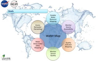
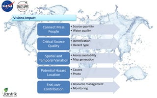
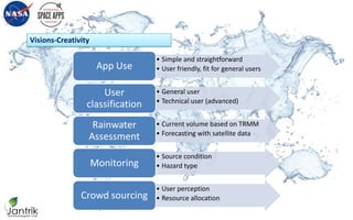
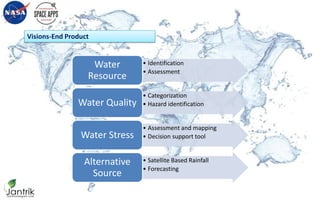
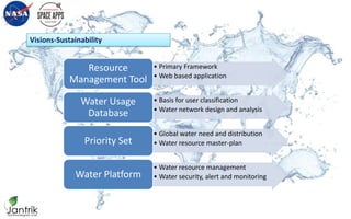
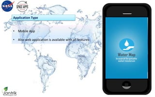
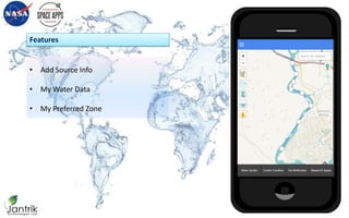
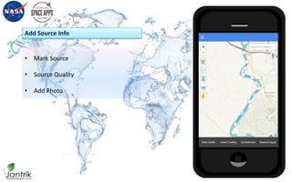
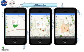
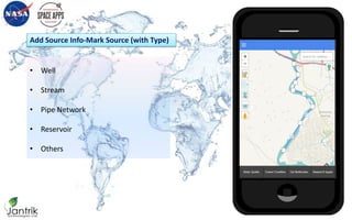
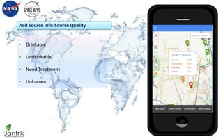
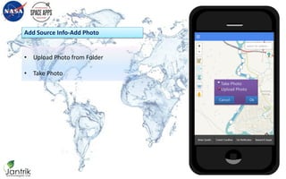
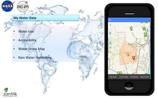
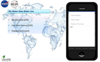
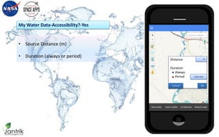
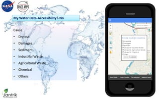
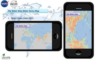
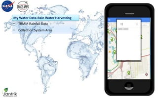
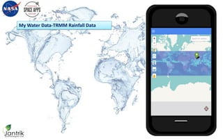
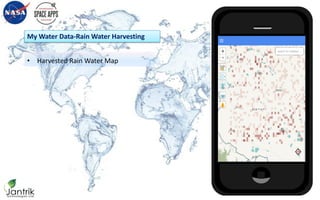
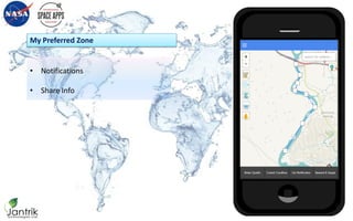
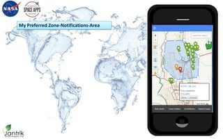
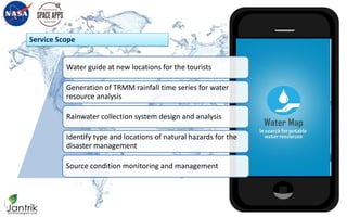
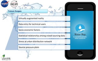
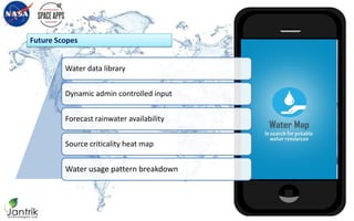
Challenge: Clean Water Mapping
Project Title: Water Map
Team Name: Jantrik-Clean Water
NASA - INTERNATIONAL SPACE APPS CHALLENGE 2015
Dhaka
April 10, 2015 – April 11, 2015
Team Members
Project Manager
Maeenul Islam
Business Development
Maeenul Islam
Adil Hassan
Mehedi Hasan Tarek
Graphics Designer
Sharif Hossain Khan
Developer
Hasan Ibrahim
Mohayeminul Islam
Nafeez Abrar
JANTRIK-CLEAN WATER
Goals
Water Map
Potable
Water
Resource
Mapping
Monitor
Source
Accessibility
Quality
Indicator
Mapping
Monitor
Source
Quality
Water
Stress Index
(WSI)
Mapping
Assess
Rainwater
Harvesting
Visions-Impact
• Source quantity
• Water quality
Connect Mass
People
• Identification
• Hazard type
Critical Source
Quality
• Assess availability
• Map generation
Spatial and
Temporal Variation
• Causes
• Photo
Potential Hazard
Location
• Resource management
• Monitoring
End-user
Contribution
Visions-Creativity
• Simple and straightforward
• User friendly, fit for general usersApp Use
• General user
• Technical user (advanced)
User
classification
• Current volume based on TRMM
• Forecasting with satellite data
Rainwater
Assessment
• Source condition
• Hazard typeMonitoring
• User perception
• Resource allocationCrowd sourcing
Visions-End Product
• Identification
• Assessment
Water
Resource
• Categorization
• Hazard identificationWater Quality
• Assessment and mapping
• Decision support toolWater Stress
• Satellite Based Rainfall
• Forecasting
Alternative
Source
Visions-Sustainability
• Primary Framework
• Web based application
Resource
Management Tool
• Basis for user classification
• Water network design and analysis
Water Usage
Database
• Global water need and distribution
• Water resource master-planPriority Set
• Water resource management
• Water security, alert and monitoringWater Platform
• Mobile App
• Also web application is available with all features
Application Type
• Add Source Info
• My Water Data
• My Preferred Zone
Features
Features
• Mark Source
• Source Quality
• Add Photo
Add Source Info
Add Source Info
Add Source Info
• Well
• Stream
• Pipe Network
• Reservoir
• Others
Add Source Info-Mark Source (with Type)
Add Source Info
Source Type
Well
Stream
Pipe Network
Reservoir
Other
OkCancel
• Drinkable
• Undrinkable
• Need Treatment
• Unknown
Add Source Info-Source Quality
Add Source Info
Source Quality
Drinkable
Undrinkable
Need Treatment
Unknown
OkCancel
• Upload Photo from Folder
• Take Photo
Add Source Info-Add Photo
Add Source Info
Take Photo
Upload Photo
OkCancel
• Water Use
• Accessibility
• Water Stress Map
• Rain Water Harvesting
My Water Data
My Water Data
• My Demand (LPD)
• Use from Source (LPD)
• Population (Count)
My Water Data-Water Use
My Demand
Use from Source
Population
Cancel
LPD
LPD
#
Ok
• Source Distance (m)
• Duration (always or period)
My Water Data-Accessibility?-Yes
My Water Data
Cancl
Distance
Duration
Always
Period
Cancel
m
Calendar
Ok
Cause
• Dry out
• Damages
• Sediment
• Industrial Waste
• Agricultural Waste
• Chemical
• Others
My Water Data-Accessibility?-No
• Water Stress Index (WSI)
My Water Data-Water Stress Map
My Water Data
My Water Data
• TRMM Rainfall Data
• Collection System Area
My Water Data-Rain Water Harvesting
My Water Data
My Water Data-TRMM Rainfall Data
• Harvested Rain Water Map
My Water Data-Rain Water Harvesting
My Water Data
• Notifications
• Share Info
My Preferred Zone
My Preferred Zone
My Preferred Zone-Notifications-Area
My Preferred Zone
Notify about-
New Source
Quality
Accessibility
Dry out
Damages
Water Stress Index
OkCancel
My Preferred Zone-Notifications
My Preferred Zone
Notify about-
New Source
Quality
Accessibility
Dry out
Damages
Water Stress Index
OkCancel
Service Scope
Water Map
in search for potable water resources
Water guide at new locations for the tourists
Generation of TRMM rainfall time series for water
resource analysis
Rainwater collection system design and analysis
Identify type and locations of natural hazards for the
disaster management
Source condition monitoring and management
Future Scopes
Water Map
in search for potable water resources
Virtually augmented reality
Data entry for technical users
Socio-economic factors
Statistical relationship among crowd sourcing data
Stress at urban distribution network
Source pressure plain
Future Scopes
Water Map
in search for potable water resources
Water data library
Dynamic admin controlled input
Forecast rainwater availability
Source criticality heat map
Water usage pattern breakdown
Thank You

Jantrik cleanwater watermap

  • 1.
    Challenge: Clean WaterMapping Project Title: Water Map Team Name: Jantrik-Clean Water NASA - INTERNATIONAL SPACE APPS CHALLENGE 2015 Dhaka April 10, 2015 – April 11, 2015
  • 2.
    Team Members Project Manager MaeenulIslam Business Development Maeenul Islam Adil Hassan Mehedi Hasan Tarek Graphics Designer Sharif Hossain Khan Developer Hasan Ibrahim Mohayeminul Islam Nafeez Abrar JANTRIK-CLEAN WATER
  • 3.
  • 4.
    Visions-Impact • Source quantity •Water quality Connect Mass People • Identification • Hazard type Critical Source Quality • Assess availability • Map generation Spatial and Temporal Variation • Causes • Photo Potential Hazard Location • Resource management • Monitoring End-user Contribution
  • 5.
    Visions-Creativity • Simple andstraightforward • User friendly, fit for general usersApp Use • General user • Technical user (advanced) User classification • Current volume based on TRMM • Forecasting with satellite data Rainwater Assessment • Source condition • Hazard typeMonitoring • User perception • Resource allocationCrowd sourcing
  • 6.
    Visions-End Product • Identification •Assessment Water Resource • Categorization • Hazard identificationWater Quality • Assessment and mapping • Decision support toolWater Stress • Satellite Based Rainfall • Forecasting Alternative Source
  • 7.
    Visions-Sustainability • Primary Framework •Web based application Resource Management Tool • Basis for user classification • Water network design and analysis Water Usage Database • Global water need and distribution • Water resource master-planPriority Set • Water resource management • Water security, alert and monitoringWater Platform
  • 8.
    • Mobile App •Also web application is available with all features Application Type
  • 9.
    • Add SourceInfo • My Water Data • My Preferred Zone Features Features
  • 10.
    • Mark Source •Source Quality • Add Photo Add Source Info Add Source Info
  • 11.
  • 12.
    • Well • Stream •Pipe Network • Reservoir • Others Add Source Info-Mark Source (with Type) Add Source Info Source Type Well Stream Pipe Network Reservoir Other OkCancel
  • 13.
    • Drinkable • Undrinkable •Need Treatment • Unknown Add Source Info-Source Quality Add Source Info Source Quality Drinkable Undrinkable Need Treatment Unknown OkCancel
  • 14.
    • Upload Photofrom Folder • Take Photo Add Source Info-Add Photo Add Source Info Take Photo Upload Photo OkCancel
  • 15.
    • Water Use •Accessibility • Water Stress Map • Rain Water Harvesting My Water Data My Water Data
  • 16.
    • My Demand(LPD) • Use from Source (LPD) • Population (Count) My Water Data-Water Use My Demand Use from Source Population Cancel LPD LPD # Ok
  • 17.
    • Source Distance(m) • Duration (always or period) My Water Data-Accessibility?-Yes My Water Data Cancl Distance Duration Always Period Cancel m Calendar Ok
  • 18.
    Cause • Dry out •Damages • Sediment • Industrial Waste • Agricultural Waste • Chemical • Others My Water Data-Accessibility?-No
  • 19.
    • Water StressIndex (WSI) My Water Data-Water Stress Map My Water Data My Water Data
  • 20.
    • TRMM RainfallData • Collection System Area My Water Data-Rain Water Harvesting My Water Data
  • 21.
    My Water Data-TRMMRainfall Data
  • 22.
    • Harvested RainWater Map My Water Data-Rain Water Harvesting My Water Data
  • 23.
    • Notifications • ShareInfo My Preferred Zone My Preferred Zone
  • 24.
    My Preferred Zone-Notifications-Area MyPreferred Zone Notify about- New Source Quality Accessibility Dry out Damages Water Stress Index OkCancel
  • 25.
    My Preferred Zone-Notifications MyPreferred Zone Notify about- New Source Quality Accessibility Dry out Damages Water Stress Index OkCancel
  • 26.
    Service Scope Water Map insearch for potable water resources Water guide at new locations for the tourists Generation of TRMM rainfall time series for water resource analysis Rainwater collection system design and analysis Identify type and locations of natural hazards for the disaster management Source condition monitoring and management
  • 27.
    Future Scopes Water Map insearch for potable water resources Virtually augmented reality Data entry for technical users Socio-economic factors Statistical relationship among crowd sourcing data Stress at urban distribution network Source pressure plain
  • 28.
    Future Scopes Water Map insearch for potable water resources Water data library Dynamic admin controlled input Forecast rainwater availability Source criticality heat map Water usage pattern breakdown
  • 29.