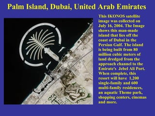
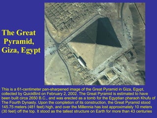
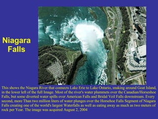
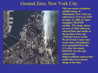
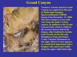
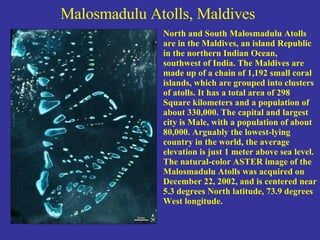
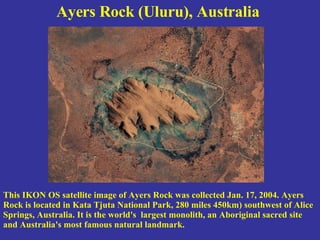
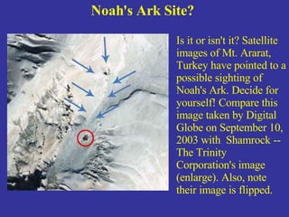
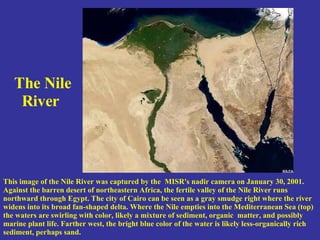
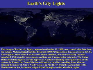
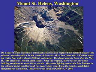
This summary provides an overview of 3 satellite images described in the document:
1) An IKONOS satellite image from July 2004 shows Palm Island in Dubai, a man-made island being built from dredged materials. It will contain residences, parks, and other amenities once complete.
2) A QuickBird image from February 2002 depicts the Great Pyramid of Giza in Egypt, estimated to have been built in 2650 BC as a tomb for Pharaoh Khufu. It originally stood 145 meters tall but has lost about 10 meters over millennia.
3) An image from August 2004 captures Niagara Falls, where most of the Niagara River's water plun
Volcanoes are a natural and drastic erosion of hard crust due to high temperature below surface level. A small hole burst in the Ziarat region of Pakistan created small lava with no prior volcanic activity.
Surreal places in the world that transport you to the world of fantasy. Many surreal places are present in the world which are extremely beautiful & mind-blowing.
50 +1 Strange Wonders on Earth - PowerPointYaryalitsa
51 natural wonders of the world but strange at the same time, presented in a colourful PowerPoint with a small description for each.
PowerPoint needs to be downloaded to view animation on the first and last slide.
Other PowerPoints by me at the following URL on slideshare:
Top Ten Australian Landforms
http://www.slideshare.net/yaryalitsa/powerpoint-top-10-australian-landforms
Weird Landscapes – one finds on Earth
http://www.slideshare.net/yaryalitsa/weird-landscapes-one-finds-on-earth
10 Natural Wonder of the World
http://www.slideshare.net/yaryalitsa/10-natural-wonders-of-the-world-powerpoint
Get the information about Bermuda triangle and u can give presentation about it. It is unsolved till now, but assumptions are made and still the predictions are done,,,,,,
Three Sisters and Whychus Creek— A Geologic Past and PresentDesLandTrust
Join Ellen Morris Bishop, noted geologist, author, and photographer, for a talk on the geologic history of the Sisters and Whychus Creek. Ellen will discuss the geology of the Three Sisters region and the early volcanism revealed in Whychus Creek’s lower stretches.
Stealing the Oceans: Humanity Struggles for Survival in This 1000 Year Epic W...Rick Doble
Stealing the Oceans by Rick Doble is a hard science fiction novella based on our current understanding of science and technology. An unusual SF story, it covers 1000 years when the people of the Earth are forced to make drastic changes. This occurs because ocean levels begin to gradually fall for hundreds of years -- with no end in sight. Using the latest technology, world governments work to determine the reason. But the discovery of the cause leads to panic and desperate attempts to rebuild civilizations. This epic story is as much about the forces involved as the individual people -- and comes complete with a city directory for one of the new cities that is established, along with a full description of how a new culture evolved.
2137ad - Characters that live in Merindol and are at the center of main storiesluforfor
Kurgan is a russian expatriate that is secretly in love with Sonia Contado. Henry is a british soldier that took refuge in Merindol Colony in 2137ad. He is the lover of Sonia Contado.
Hadj Ounis's most notable work is his sculpture titled "Metamorphosis." This piece showcases Ounis's mastery of form and texture, as he seamlessly combines metal and wood to create a dynamic and visually striking composition. The juxtaposition of the two materials creates a sense of tension and harmony, inviting viewers to contemplate the relationship between nature and industry.
Explore the multifaceted world of Muntadher Saleh, an Iraqi polymath renowned for his expertise in visual art, writing, design, and pharmacy. This SlideShare delves into his innovative contributions across various disciplines, showcasing his unique ability to blend traditional themes with modern aesthetics. Learn about his impactful artworks, thought-provoking literary pieces, and his vision as a Neo-Pop artist dedicated to raising awareness about Iraq's cultural heritage. Discover why Muntadher Saleh is celebrated as "The Last Polymath" and how his multidisciplinary talents continue to inspire and influence.
2137ad Merindol Colony Interiors where refugee try to build a seemengly norm...luforfor
This are the interiors of the Merindol Colony in 2137ad after the Climate Change Collapse and the Apocalipse Wars. Merindol is a small Colony in the Italian Alps where there are around 4000 humans. The Colony values mainly around meritocracy and selection by effort.
2137ad Merindol Colony Interiors where refugee try to build a seemengly norm...
Amazing Top Satelite View Photo
1. Some Great Satellite Images with good descriptive information
2. Palm Island, Dubai, United Arab Emirates This IKONOS satellite image was collected on July 16, 2004. The Image shows this man-made island that lies off the coast of Dubai in the Persian Gulf. The island is being built from 80 million cubic meters of land dredged from the approach channel to the Emirate's Jebel Ali Port. When complete, this resort will have 1,200 single-family and 600 multi-family residences, an aquatic Theme park, shopping centers, cinemas and more.
3. The Great Pyramid, Giza, Egypt This is a 61-centimeter pan-sharpened image of the Great Pyramid in Giza, Egypt, collected by QuickBird on February 2, 2002. The Great Pyramid is estimated to have been built circa 2650 B.C., and was erected as a tomb for the Egyptian pharaoh Khufu of The Fourth Dynasty. Upon the completion of its construction, the Great Pyramid stood 145.75 meters (481 feet) high, and over the Millennia has lost approximately 10 meters (30 feet) off the top. It stood as the tallest structure on Earth for more than 43 centuries
4. Niagara Falls This shows the Niagara River that connects Lake Erie to Lake Ontario, snaking around Goat Island, in the lower left of the full Image. Most of the river's water plummets over the Canadian/Horseshoe Falls, but some diverted water spills over American Falls and Bridal Veil Falls downstream. Every second, more Than two million liters of water plunges over the Horsehoe Falls Segment of Niagara Falls creating one of the world's largest Waterfalls as well as eating away as much as two meters of rock per Year. The image was acquired August 2, 2004
5. Tsunami strikes the coast of Sri Lanka This is a natural color, 60-centimeter (2-foot) high-resolution QuickBird satellite image featuring the southwestern coast of Sri Lanka. Imagery was collected on December 26, 2004 at 10:20 a.m. Local time, slightly less than four hours after the 6:28 a.m. (local Sri Lanka time) earthquake and shortly after the moment of tsunami impact.
6. Ground Zero, New York City This one-meter resolution satellite image of Manhattan, New York was collected at 11:43 a.m. EDT on Sept. 12, 2001 by Space Imaging's IKONOS satellite. The image shows an area of white and gray-colored Dust and smoke at the location where the 1,350-foot towers of the World Trade Center once stood. Since all airplanes were grounded Over the U.S. after the attack, IKONOS was the only commercial High-resolution camera that could take an overhead image at the time.
7. Grand Canyon Northern Arizona and the Grand Canyon are captured in this pair of Multi-angle Imaging Spectroradiometer (MISR) images from December 31, 2000. The above image is a true color view from the nadir Vertical camera. In addition to the Grand Canyon itself, which is visible in the western (lower) half of the images, other landmarks include Lake Powell, on the left, and Humphreys Peak and Sunset Crater National Monument on the right. Meteor Crater appears as a small dark depression with a brighter rim, and is just visible along the upper right-hand edge.
8. Malosmadulu Atolls, Maldives North and South Malosmadulu Atolls are in the Maldives, an island Republic in the northern Indian Ocean, southwest of India. The Maldives are made up of a chain of 1,192 small coral islands, which are grouped into clusters of atolls. It has a total area of 298 Square kilometers and a population of about 330,000. The capital and largest city is Male, with a population of about 80,000. Arguably the lowest-lying country in the world, the average elevation is just 1 meter above sea level. The natural-color ASTER image of the Malosmadulu Atolls was acquired on December 22, 2002, and is centered near 5.3 degrees North latitude, 73.9 degrees West longitude.
9. Ayers Rock (Uluru), Australia This IKON OS satellite image of Ayers Rock was collected Jan. 17, 2004. Ayers Rock is located in Kata Tjuta National Park, 280 miles 450km) southwest of Alice Springs, Australia. It is the world's largest monolith, an Aboriginal sacred site and Australia's most famous natural landmark.
10. Noah's Ark Site? Is it or isn't it? Satellite images of Mt. Ararat, Turkey have pointed to a possible sighting of Noah's Ark. Decide for yourself! Compare this image taken by Digital Globe on September 10, 2003 with Shamrock -- The Trinity Corporation's image (enlarge). Also, note their image is flipped.
11. The Nile River This image of the Nile River was captured by the MISR's nadir camera on January 30, 2001. Against the barren desert of northeastern Africa, the fertile valley of the Nile River runs northward through Egypt. The city of Cairo can be seen as a gray smudge right where the river widens into its broad fan-shaped delta. Where the Nile empties into the Mediterranean Sea (top) the waters are swirling with color, likely a mixture of sediment, organic matter, and possibly marine plant life. Farther west, the bright blue color of the water is likely less-organically rich sediment, perhaps sand.
12. Earth's City Lights This image of Earth's city lights, captured on October 19, 2000, was created with data from the Defense Meteorological Satellite Program (DMSP) Operational Linescan System (OLS). The brightest areas of the Earth are the most urbanized, but not necessarily the most populated. Cities tend to grow along coastlines and transportation networks. The United States interstate highway system appears as a lattice connecting the brighter dots of city centers. In Russia, the Trans-Siberian railroad is a thin line stretching from Moscow through the center of Asia to Vladivostok. The Nile River, from the Aswan Dam to the Mediterranean Sea, is another bright thread through an otherwise dark region.
13. Mount St. Helens, Washington On a Space Station expedition, astronauts observed and captured this detailed image of the volcano's summit caldera. In the center of the crater sits a lava dome that is 876 feet above the crater floor and is about 3,500 feet in diameter. The dome began to form after the May 18, 1980 eruption of Mount Saint Helens. After the eruption, there was not any dome building eruptions for more than a decade. Afternoon lighting accents the flow features in the volcanic and debris flows and the steep valleys eroded into the loosely consolidated material near the summit. This picture was taken on October 25, 2002.