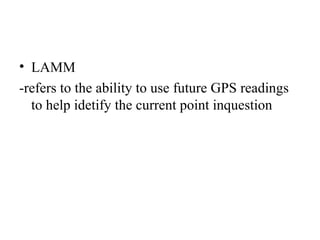
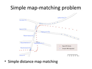
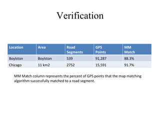
Improving  Wireless Positioning with Look-ahead Map-Matching 學生 : 張佑任 老師 : 劉宏煥老師
Jones, Kipp; Liu, Ling; Alizadeh-Shabdiz, Farshid; ”Improving Wireless Positioning with Look-ahead Map-Matching”,  The Fourth Annual International Conference on Mobile and Ubiquitous Systems: Computing, Networking and Services, P.1 – 8 , 6-10 Aug, 2007.   Reference
outline Introduction Method Algorithms Verification Conclusion
Introduction WiFi Positioning Services rely on the accuracy of WiFi beacons Use digital map to improve WiFi APs’ location estimation process Use map-matching to improving the estimation of the location of a vehical during scanning for access points
Method Wardriving the searching for Wi-Fi wireless networks by moving vehicle. collect information about wireless access points. Map-matching compare the geographic coordinates of digital map’s object against the GPS coordinates to constrain the GPS readings to point lie on the road
LAMM -refers to the ability to use future GPS readings to help idetify the current point inquestion
Algorithm Simple Distance Based Matching Map-matching with look-ahead Look-Ahead MM with Smothness Constraint
Simple map-matching problem  Simple distance map matching
Map-matching with look-ahead Step1:fill buffer Step2:seed candidate tracks
Step3:extend candidate tracks Step4:choose best set of candidate tracks Step5:get the next GPS readings Step6:find best tracks Step7:start next session and biging at step 1
Basic look-ahead map-matching.
Look-ahead MM with Smoothness Constraint Add a new factor to distance-based smoothness into LAMM. This factor compare the distance between subswquent GPS readings and the distance between their associateed adjusted locations
 
 
Verification MM Match column represents the percent of GPS points that the map matching algorithm successfully matched to a road segment. Location Area Road Segments GPS Points MM Match Boylston Boylston 539 91,287 88.3% Chicago 11 km2 2752 15,591 91.7%
CDF for Boylstom Averaging approximately 5% improvement for each GPS points
Averaging approximately 13% improvement for each GPS points
Conclusion Outdoor wireless positioning systems based on WiFi access points  Understanding  such a system and determining methods to improve accuracy could enhance the usefulness of WiFi positioning systems in providing location based services.

[I]Improving Wireless Positioning With Look Ahead Map Matching

  • 1.
    Improving WirelessPositioning with Look-ahead Map-Matching 學生 : 張佑任 老師 : 劉宏煥老師
  • 2.
    Jones, Kipp; Liu,Ling; Alizadeh-Shabdiz, Farshid; ”Improving Wireless Positioning with Look-ahead Map-Matching”, The Fourth Annual International Conference on Mobile and Ubiquitous Systems: Computing, Networking and Services, P.1 – 8 , 6-10 Aug, 2007. Reference
  • 3.
    outline Introduction MethodAlgorithms Verification Conclusion
  • 4.
    Introduction WiFi PositioningServices rely on the accuracy of WiFi beacons Use digital map to improve WiFi APs’ location estimation process Use map-matching to improving the estimation of the location of a vehical during scanning for access points
  • 5.
    Method Wardriving thesearching for Wi-Fi wireless networks by moving vehicle. collect information about wireless access points. Map-matching compare the geographic coordinates of digital map’s object against the GPS coordinates to constrain the GPS readings to point lie on the road
  • 6.
    LAMM -refers tothe ability to use future GPS readings to help idetify the current point inquestion
  • 7.
    Algorithm Simple DistanceBased Matching Map-matching with look-ahead Look-Ahead MM with Smothness Constraint
  • 8.
    Simple map-matching problem Simple distance map matching
  • 9.
    Map-matching with look-aheadStep1:fill buffer Step2:seed candidate tracks
  • 10.
    Step3:extend candidate tracksStep4:choose best set of candidate tracks Step5:get the next GPS readings Step6:find best tracks Step7:start next session and biging at step 1
  • 11.
  • 12.
    Look-ahead MM withSmoothness Constraint Add a new factor to distance-based smoothness into LAMM. This factor compare the distance between subswquent GPS readings and the distance between their associateed adjusted locations
  • 13.
  • 14.
  • 15.
    Verification MM Matchcolumn represents the percent of GPS points that the map matching algorithm successfully matched to a road segment. Location Area Road Segments GPS Points MM Match Boylston Boylston 539 91,287 88.3% Chicago 11 km2 2752 15,591 91.7%
  • 16.
    CDF for BoylstomAveraging approximately 5% improvement for each GPS points
  • 17.
    Averaging approximately 13%improvement for each GPS points
  • 18.
    Conclusion Outdoor wirelesspositioning systems based on WiFi access points Understanding such a system and determining methods to improve accuracy could enhance the usefulness of WiFi positioning systems in providing location based services.