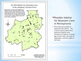
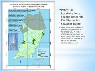
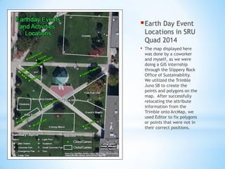
SlideShare a Scribd company logo
1 of 7
Download to read offline
GIS Portfolio 2015
*
Marcellus Shale in Pennsylvania
• Created in Cartography I (2012), these maps display the extent of
Marcellus Shale gas wells in 2012 by counties, tracts, municipalities, and
block groups.
Slippery Rock Map
• The following map shows
some of the different
characteristics occurring in
and around Slippery Rock,
PA. This map was created
in Cartography I.
Shipwrecks of St. Thomas Island
• This is my final product of the final project we were expected to
accomplish in our course of Cartography I. It was a great opportunity for
me to use my imaginative side and create modern day pirate maps.
Possible Habitat
for Mountain Lions
in Pennsylvania
• This map was created in
Advanced GIS (2014). The
criteria used to determine
potential habitat were
locations of roads or streams,
age of the trees, the type of
vegetation, and the slope of
the land.
Potential
Locations for a
Second Research
Facility on San
Salvador Island
• Here is my final product of
the final project done in
Advanced GIS. It was a
challenging project, as we
were required to apply many
types of attribute data to
attain the desired
information needed.
Earth Day Event
Locations in SRU
Quad 2014
• The map displayed here
was done by a coworker
and myself, as we were
doing a GIS internship
through the Slippery Rock
Office of Sustainability.
We utilized the Trimble
Juno SB to create the
points and polygons on the
map. After successfully
relocating the attribute
information from the
Trimble onto ArcMap, we
used Editor to fix polygons
or points that were not in
their correct positions.

More Related Content

Viewers also liked

Desarrollo de la Web
Desarrollo de la Web Desarrollo de la Web
Desarrollo de la Web john cando
 
Leventa seminarier & workshops & föreläsningar - kortversion
Leventa seminarier & workshops & föreläsningar - kortversionLeventa seminarier & workshops & föreläsningar - kortversion
Leventa seminarier & workshops & föreläsningar - kortversionLeventa AB
 
David Copperfield
David CopperfieldDavid Copperfield
David Copperfieldbea garcia
 
Transgénicos
TransgénicosTransgénicos
Transgénicoscherepaja
 
Chequeo 1 de julio del 2016
Chequeo 1 de julio del 2016Chequeo 1 de julio del 2016
Chequeo 1 de julio del 2016nico44gomez
 
Emmet and conor go to babylon
Emmet and conor go to babylonEmmet and conor go to babylon
Emmet and conor go to babylonconormedia7
 
制 度 詳 解
制 度 詳 解制 度 詳 解
制 度 詳 解a957
 
Rural Area Development Strategy through Rural Infrastructure Development Program
Rural Area Development Strategy through Rural Infrastructure Development ProgramRural Area Development Strategy through Rural Infrastructure Development Program
Rural Area Development Strategy through Rural Infrastructure Development ProgramSuwandi, Dr. SE.,MSi
 
What happens when two worlds collide? by Tej Rekhi @ ICEEfest 2013
What happens when two worlds collide? by Tej Rekhi @ ICEEfest 2013What happens when two worlds collide? by Tej Rekhi @ ICEEfest 2013
What happens when two worlds collide? by Tej Rekhi @ ICEEfest 2013ICEEFEST2013
 

Viewers also liked (16)

Desarrollo de la Web
Desarrollo de la Web Desarrollo de la Web
Desarrollo de la Web
 
HTTP/2 -- the future of WWW
HTTP/2 -- the future of WWWHTTP/2 -- the future of WWW
HTTP/2 -- the future of WWW
 
抑郁症:论文
抑郁症:论文抑郁症:论文
抑郁症:论文
 
Leventa seminarier & workshops & föreläsningar - kortversion
Leventa seminarier & workshops & föreläsningar - kortversionLeventa seminarier & workshops & föreläsningar - kortversion
Leventa seminarier & workshops & föreläsningar - kortversion
 
DOT catalogue HR
DOT catalogue HRDOT catalogue HR
DOT catalogue HR
 
David Copperfield
David CopperfieldDavid Copperfield
David Copperfield
 
Transgénicos
TransgénicosTransgénicos
Transgénicos
 
Chequeo 1 de julio del 2016
Chequeo 1 de julio del 2016Chequeo 1 de julio del 2016
Chequeo 1 de julio del 2016
 
Problema 5
Problema 5Problema 5
Problema 5
 
Emmet and conor go to babylon
Emmet and conor go to babylonEmmet and conor go to babylon
Emmet and conor go to babylon
 
CRISPR - The patent
CRISPR - The patentCRISPR - The patent
CRISPR - The patent
 
制 度 詳 解
制 度 詳 解制 度 詳 解
制 度 詳 解
 
lavadora Balay 3TW778B
lavadora Balay 3TW778Blavadora Balay 3TW778B
lavadora Balay 3TW778B
 
Rural Area Development Strategy through Rural Infrastructure Development Program
Rural Area Development Strategy through Rural Infrastructure Development ProgramRural Area Development Strategy through Rural Infrastructure Development Program
Rural Area Development Strategy through Rural Infrastructure Development Program
 
Water sanitation
Water sanitationWater sanitation
Water sanitation
 
What happens when two worlds collide? by Tej Rekhi @ ICEEfest 2013
What happens when two worlds collide? by Tej Rekhi @ ICEEfest 2013What happens when two worlds collide? by Tej Rekhi @ ICEEfest 2013
What happens when two worlds collide? by Tej Rekhi @ ICEEfest 2013
 

Hansen_GIS_Portfolio

  • 2. Marcellus Shale in Pennsylvania • Created in Cartography I (2012), these maps display the extent of Marcellus Shale gas wells in 2012 by counties, tracts, municipalities, and block groups.
  • 3. Slippery Rock Map • The following map shows some of the different characteristics occurring in and around Slippery Rock, PA. This map was created in Cartography I.
  • 4. Shipwrecks of St. Thomas Island • This is my final product of the final project we were expected to accomplish in our course of Cartography I. It was a great opportunity for me to use my imaginative side and create modern day pirate maps.
  • 5. Possible Habitat for Mountain Lions in Pennsylvania • This map was created in Advanced GIS (2014). The criteria used to determine potential habitat were locations of roads or streams, age of the trees, the type of vegetation, and the slope of the land.
  • 6. Potential Locations for a Second Research Facility on San Salvador Island • Here is my final product of the final project done in Advanced GIS. It was a challenging project, as we were required to apply many types of attribute data to attain the desired information needed.
  • 7. Earth Day Event Locations in SRU Quad 2014 • The map displayed here was done by a coworker and myself, as we were doing a GIS internship through the Slippery Rock Office of Sustainability. We utilized the Trimble Juno SB to create the points and polygons on the map. After successfully relocating the attribute information from the Trimble onto ArcMap, we used Editor to fix polygons or points that were not in their correct positions.