Download to read offline
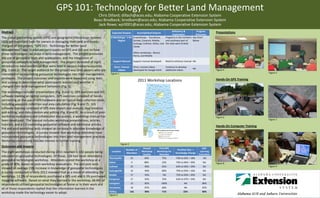

The document summarizes a project called "GPS 101: Technology for Better Land Management" that held workshops to educate landowners on GPS and GIS technologies and how they can assist in land management. The project consisted of eight introductory workshops held across various counties in Alabama. 142 people attended the workshops, most having no prior experience with geospatial technologies. Post-workshop evaluations found attendees' knowledge increased by an average of 23% and that many have since incorporated these technologies into their own land management practices. The project outcomes demonstrate that educational workshops are effective for promoting adoption of GPS and GIS tools.


