Gpr survey Ground Penetrating radar survey EpitmoeGs
•Download as PPTX, PDF•
0 likes•14 views
EpitomeGS is a gpr survey company in India. Our Services are GPR, SUE, Underground Utility, Underground Scanning & Mapping survey in India.
Report
Share
Report
Share

Recommended
SkyMap Global - Google Maps Premier Partner
A presentation of what we do at SkyMap Global. At SkyMap Global, we build powerful solutions using location intelligence and Google Maps API. By combining data from satellites, drones and even IoT devices to provide solutions for your business requirement.
My presentation
This document discusses geospatial technology and geographic information systems (GIS). It defines key terms like GIS, remote sensing, and GPS. It describes how these systems collect and analyze geographic data. The document also discusses geospatial intelligence (GEOINT) and how GIS plays an important role in military and national security applications. Specific GEOINT software and tools are also summarized, like Intergraph, Pathfinder, and the Structured Geospatial Analytic Method (SGAM). The document concludes by noting the growth of geospatial technologies across many sectors.
MCS GEOTECH (P) LTD gis solutions
The document summarizes the services provided by MCS GEOTECH (P) LTD, an organization that specializes in GIS and remote sensing. They have 10 years of experience working with government organizations. Their services include GIS software development, data collection and digitization, GPS/DGPS support, database management, and technical assistance. They have worked with various government departments in Uttar Pradesh and North Eastern India. Their infrastructure includes a 5,100 square foot GIS lab and teams of GIS professionals and software developers.
Insights success the 10 most valuable gis solution providers
Insights success the 10 most valuable gis solution providersInsights success media and technology pvt ltd
Insights Success is The Best Business Magazine in the world for enterprises. The 10 most valuable gis solution providers by insights successBrosure Laser 4D Monitoring Systems 3DLM UK Jogja
3D Laser Mapping provides laser scanning solutions including terrestrial, airborne, and mobile laser scanning. Their systems use advanced laser scanning technology and software to rapidly capture high-resolution 3D data with sub-10mm accuracy. Applications include highways, urban mapping, waterways, forestry, overhead lines, city modeling, and more. They integrate RIEGL laser scanners with 3DLM software to create robust surveying systems and offer solutions for monitoring, mapping, and mining applications around the world.
Insights success the 10 fastest growing gis solution providers 18th dec 2017
Insights success the 10 fastest growing gis solution providers 18th dec 2017Insights success media and technology pvt ltd
This document provides an overview of GeoSolutions Consulting Inc., a leading GIS solution provider. Founded in 2003 in Panama, GeoSolutions specializes in geographic information systems, satellite imagery, remote sensing, and applying these technologies to areas like natural resources, environment, and public services. The company helps clients exploit spatial data to solve complex problems effectively. GeoSolutions provides high quality satellite imagery and tools to process and analyze the images. It offers innovative products and services, and clients praise GeoSolutions' expertise, reliability, and collaboration over many years.Bhadale group of companies geology, mining industry products catalogue
This is our first version of products for the mining industry with GIS and AI based intelligent features. We use CNN, adaptive learning, connected worker platforms to engage with the whole team, use big data, spatial information and sliced analysis of the earth elements that ensures accidents and risks are at a minimum.
JA SERVICES PROFILE
The document provides an overview of services offered by Geographic Technologies Division (JAZERA ACCESS), including GIS implementation, data creation, software solutions, field data collection using GPS, custom application development, training and support. It highlights two key GIS implementation projects completed for major clients in Saudi Arabia: a VDSL power project for Saudi Telecom Company connecting over 850 sites, and a full GIS project for Saudi Electric Company. The company provides end-to-end GIS consulting and services to meet the needs of utilities, local government and other sectors.
Optimize Land Surveying with Drones: Accurate Data, Faster Results.pdf
Discover how drones are revolutionizing land survey drone. Explore the benefits of using drones for precise topographic mapping, construction site monitoring, and environmental assessments. Drones provide high-resolution aerial imagery, 3D modeling, and efficient data collection, reducing surveying time and costs. Uncover how drone technology improves safety by minimizing fieldwork risks and enhances decision-making with real-time insights. Maximize efficiency and accuracy in land surveying projects with drones, staying ahead in today's competitive landscape.
2Find Me English
2FindMe is a web-based GPS tracking platform that allows users to track vehicles, people, and valuable objects in real-time. It provides location data, speed, direction, and alerts via email or SMS. The service can track devices via cell phones, tablets, or dedicated trackers like the NAT-G1 device. NAT-G1 provides additional features like driver identification, remote engine control, and cabin photo capture. 2FindMe supports mapping of locations in the Middle East and allows customization of maps. The system is available as both a cloud service and private on-premise installation.
The Best Performing GIS Companies To Follow In 2023.pdf
The document discusses Heliware, a leading GIS technology provider known for its 3D geospatial location insights and analytics platform. It provides details about Heliware's capabilities like easy-to-use interfaces, scalable cloud platform, and data visualization tools. The company's CEO, Rajan Srivastav, emphasizes that Heliware takes pride in serving diverse clients through its products and solutions. Heliware is considered a top company to follow due to its powerful mapping tools, user-friendly design, partnerships, and focus on continual innovation.
A revolution for a better management
The advent of technology and the vision to keep track with the latest technology, we the RKM group now indulging us in the field of GIS to integrate the mission friendly environment.
Moreover, the branch of GIS is a peculiar stream to convey the message of nature in visualizing, analyzing, interpreting the wide geographically concern scenario. A decision making tool that helps provide a better assessment and utilization of the resources.
Geospatial Surveying
Phase One offers precision aerial 2D and 3D mapping cameras and photogrammetry solutions that simplify aerial survey and mapping processes. With a diverse and easy-to-integrate line of products, Phase One provides unlimited, accurate, and reliable aerial data that enables users to effortlessly execute photogrammetry and mapping missions, capture high-resolution images, and perform 2D and 3D mapping. Phase One Geospatial Solutions also offer 4-band, combining NIR and RGB aerial imagery for various agricultural and forestry applications.
Adavanced GIS Solution
TekMindz develops innovative geographic information system (GIS) solutions that integrate location data with business applications. They offer services including digital photogrammetry, GIS mapping, remote sensing, data conversion, training, and application development. For example, they created a web-based GIS portal for a New Zealand council to manage land records and utilities.
50120140501008
The document discusses implementing geo-messaging on Android using Google Cloud Messaging (GCM) and Location Based Services APIs. It proposes an application that sends messages to users when they are near a specified location using geo-fencing. The application uses GCM to push messages from a server to devices and Location Services to detect when devices enter or exit geo-fenced areas to trigger message delivery. The document outlines the system architecture, registration process, geo-fencing implementation, and concludes discussing potential future applications of location-based services.
IRJET- A System for Indoor Navigation: GuideIt - Personal Assistant
The document describes a proposed Android application called GuideIt that aims to provide indoor navigation assistance using step counting and augmented reality. The application would use sensors like the accelerometer and GPS on a smartphone, along with image recognition, to guide users inside complex indoor environments like malls, universities, and hospitals. It discusses related indoor navigation technologies and the limitations of GPS for indoor use. The proposed application seeks to offer a low-cost indoor navigation solution by counting a user's steps based on a path recorded previously by an administrator and providing turn-by-turn voice directions.
LiDAR Technology | LiDAR systems
LiDAR, short for light detection and ranging, is a remote sensing technology that uses light in the form of a pulsed laser to measure ranges (distances) to a target. A LiDAR sensor fires off beams of laser light and then measures how long it takes for the light to return to the sensor.
The costs of building and using LIDAR systems are coming down because it’s becoming easier and cheaper to collect more and more data, and LIDAR is being used in more applications.
At Techwave, we strive to be a world-class lighting technology provider. With that role comes the responsibility to be intimately familiar with newer applications and help our partners understand the real value in them.
Geo location based augmented reality application
This document describes the development of a geo-location based augmented reality application using the GART toolkit. It discusses key components like GPS, cameras and displays. It outlines the workflow which takes camera input, matches coordinates from GPS and augments information on the display. It also discusses setting up the environment in Visual Studio, designing the interface in XAML, and programming the code behind in C#. The application developed uses GART to overlay location information directly based on a device's position rather than relying on markers.
Inventory Mapping_r5a
Our solution provides total mapping and statistics solutions for plantations using unmanned aerial vehicles, GNSS, photogrammetry, and GIS. Key steps include acquiring high-resolution imagery via UAV, extracting geospatial data on plantation assets like roads and palm counts, and managing the data in a GIS database for uses like resource allocation, yield forecasting, and monitoring financial performance. The company offers UAV aerial survey packages for tasks like monitoring, general mapping, creating base maps, and topography extraction to support plantation management needs.
Gis Talk To Cio Group Transp Final Pp2003 X09
The document discusses how GIS has become essential for business use. It provides examples of how various companies use GIS for applications like supply chain management, customer mapping, and enterprise integration. The document also examines challenges of GIS implementation and the trend of GIS moving to web and mobile platforms to better serve customers and consumers.
ArcGIS: A Platform for Intelligent 3D Imagery
The ArcGIS platform provides more than just 3D maps by enabling users to share, create, and add 3D content through web browsers and mobile apps. It allows existing 2D data and processes to be used to automate the creation of 3D models from imagery and lidar data. This facilitates large-scale 3D mapping of cities, facilities, and other areas. The platform also supports augmented reality and delivering 3D content anywhere through web scenes.
Basket Strainer Supplier India -Bliss flow systems
Bliss Flow Systems is a supplier & distributor of Basket Strainer in India, Singapore, UAE. Contact us for a Quotation
Solenoid Valve Supplier - Bliss flow systems
A solenoid valve is an electromechanical device that controls the flow of a liquid or gas through a pipe or tubing system. It consists of a coil of wire, called a solenoid, which when energized creates a magnetic field that opens or closes a valve mechanism, allowing or stopping the flow of fluid
Drone Survey Mapping | Aerial Photography Survey Mapping - Eptiome
In the vast realm of surveying techniques, Epitome provide drone aerial photography survey have emerged as a transformative technology, offering a unique perspective from the sky. This article delves into the evolution, applications, and future trends of drone aerial photography survey, unraveling the myriad advantages and challenges associated with this cutting-edge approach. Drone surveys have revolutionized the field of data collection, offering a nimble and efficient alternative to traditional survey methods. These unmanned aerial vehicles, equipped with advanced sensors and cameras, enable the rapid and cost-effective acquisition of high-resolution imagery and geospatial data.
Drone Survey Mapping | Aerial Photography Survey - EpitomeGs
Epitome Geotechnical is a Geo survey Mapping company in India. Our services are Drone Survey and Aerial Photography Survey Services in India.
visit: www.epitomegs.com
Epitome Geotechnical Pvt. Limited Noida
Epitome Geotechnical is a GEO survey company in India. Our services are GPR, DPR preparation, Ground water, Bathymetric / Hydrographic, MASW & Seismic Refraction
GPR Survey | Ground Penetrating Radar Survey
Ground Penetrating Radar (GPR) operates by transmitting high-frequency radio waves pulses down into the ground through an antenna. Ground Penetrating Radar is distinctly able at not only mapping buried structures but also relatively measuring their depth, and supplying an all-important thorough detail.
The antenna is moved over the surface to be inspected. The transmitter redirects a diverging beam of energy which is reflected in various underground objects or different contacts between different earth materials.
Solenoid Valve | Choke Valve Supplier Singapore
Bliss Flow Systems Supplier & Distributor of Solenoid Vale, Choke Valve, Self Actuated Pressure Regulator, Waste Heat Recovery boiler supplier in Singapore. Our range of products include gauges, switches, transmitters, electric heaters, heat exchangers, flame arresters, rupture discs, rupture pin valves, safety relief valves, strainers, manual / automated valves, solenoid valves, positioners, gas regulators, choke valves, mist eliminators, vibration transmitters, vibration switches, dampers, expansion joints, pipes, tubes, fittings and many more
Basket Strainer Supplier in India
Basket Strainer, Size 25 NB to 1000 NB, Cast and Fabricated Carbon Steel, Stainless Steel, Alloy Steel. Supplied to India, Middle East, Singapore and Malaysia.
visit: https://blissflowsystems.com/product/basket-strainer/
Excellon DNC | NC DRill | PCB DNC CAM Support - Fastechnologies
FASTechnologies.com offering CNC Programming, CAM Support, Annual Maintenance Plan, Excellon DNC, CNC6 DNC, System2000 DNC, NC Rout & Drill, PCB DNC, CNC6 Keyboard & Monitor.
More Related Content
Similar to Gpr survey Ground Penetrating radar survey EpitmoeGs
Optimize Land Surveying with Drones: Accurate Data, Faster Results.pdf
Discover how drones are revolutionizing land survey drone. Explore the benefits of using drones for precise topographic mapping, construction site monitoring, and environmental assessments. Drones provide high-resolution aerial imagery, 3D modeling, and efficient data collection, reducing surveying time and costs. Uncover how drone technology improves safety by minimizing fieldwork risks and enhances decision-making with real-time insights. Maximize efficiency and accuracy in land surveying projects with drones, staying ahead in today's competitive landscape.
2Find Me English
2FindMe is a web-based GPS tracking platform that allows users to track vehicles, people, and valuable objects in real-time. It provides location data, speed, direction, and alerts via email or SMS. The service can track devices via cell phones, tablets, or dedicated trackers like the NAT-G1 device. NAT-G1 provides additional features like driver identification, remote engine control, and cabin photo capture. 2FindMe supports mapping of locations in the Middle East and allows customization of maps. The system is available as both a cloud service and private on-premise installation.
The Best Performing GIS Companies To Follow In 2023.pdf
The document discusses Heliware, a leading GIS technology provider known for its 3D geospatial location insights and analytics platform. It provides details about Heliware's capabilities like easy-to-use interfaces, scalable cloud platform, and data visualization tools. The company's CEO, Rajan Srivastav, emphasizes that Heliware takes pride in serving diverse clients through its products and solutions. Heliware is considered a top company to follow due to its powerful mapping tools, user-friendly design, partnerships, and focus on continual innovation.
A revolution for a better management
The advent of technology and the vision to keep track with the latest technology, we the RKM group now indulging us in the field of GIS to integrate the mission friendly environment.
Moreover, the branch of GIS is a peculiar stream to convey the message of nature in visualizing, analyzing, interpreting the wide geographically concern scenario. A decision making tool that helps provide a better assessment and utilization of the resources.
Geospatial Surveying
Phase One offers precision aerial 2D and 3D mapping cameras and photogrammetry solutions that simplify aerial survey and mapping processes. With a diverse and easy-to-integrate line of products, Phase One provides unlimited, accurate, and reliable aerial data that enables users to effortlessly execute photogrammetry and mapping missions, capture high-resolution images, and perform 2D and 3D mapping. Phase One Geospatial Solutions also offer 4-band, combining NIR and RGB aerial imagery for various agricultural and forestry applications.
Adavanced GIS Solution
TekMindz develops innovative geographic information system (GIS) solutions that integrate location data with business applications. They offer services including digital photogrammetry, GIS mapping, remote sensing, data conversion, training, and application development. For example, they created a web-based GIS portal for a New Zealand council to manage land records and utilities.
50120140501008
The document discusses implementing geo-messaging on Android using Google Cloud Messaging (GCM) and Location Based Services APIs. It proposes an application that sends messages to users when they are near a specified location using geo-fencing. The application uses GCM to push messages from a server to devices and Location Services to detect when devices enter or exit geo-fenced areas to trigger message delivery. The document outlines the system architecture, registration process, geo-fencing implementation, and concludes discussing potential future applications of location-based services.
IRJET- A System for Indoor Navigation: GuideIt - Personal Assistant
The document describes a proposed Android application called GuideIt that aims to provide indoor navigation assistance using step counting and augmented reality. The application would use sensors like the accelerometer and GPS on a smartphone, along with image recognition, to guide users inside complex indoor environments like malls, universities, and hospitals. It discusses related indoor navigation technologies and the limitations of GPS for indoor use. The proposed application seeks to offer a low-cost indoor navigation solution by counting a user's steps based on a path recorded previously by an administrator and providing turn-by-turn voice directions.
LiDAR Technology | LiDAR systems
LiDAR, short for light detection and ranging, is a remote sensing technology that uses light in the form of a pulsed laser to measure ranges (distances) to a target. A LiDAR sensor fires off beams of laser light and then measures how long it takes for the light to return to the sensor.
The costs of building and using LIDAR systems are coming down because it’s becoming easier and cheaper to collect more and more data, and LIDAR is being used in more applications.
At Techwave, we strive to be a world-class lighting technology provider. With that role comes the responsibility to be intimately familiar with newer applications and help our partners understand the real value in them.
Geo location based augmented reality application
This document describes the development of a geo-location based augmented reality application using the GART toolkit. It discusses key components like GPS, cameras and displays. It outlines the workflow which takes camera input, matches coordinates from GPS and augments information on the display. It also discusses setting up the environment in Visual Studio, designing the interface in XAML, and programming the code behind in C#. The application developed uses GART to overlay location information directly based on a device's position rather than relying on markers.
Inventory Mapping_r5a
Our solution provides total mapping and statistics solutions for plantations using unmanned aerial vehicles, GNSS, photogrammetry, and GIS. Key steps include acquiring high-resolution imagery via UAV, extracting geospatial data on plantation assets like roads and palm counts, and managing the data in a GIS database for uses like resource allocation, yield forecasting, and monitoring financial performance. The company offers UAV aerial survey packages for tasks like monitoring, general mapping, creating base maps, and topography extraction to support plantation management needs.
Gis Talk To Cio Group Transp Final Pp2003 X09
The document discusses how GIS has become essential for business use. It provides examples of how various companies use GIS for applications like supply chain management, customer mapping, and enterprise integration. The document also examines challenges of GIS implementation and the trend of GIS moving to web and mobile platforms to better serve customers and consumers.
ArcGIS: A Platform for Intelligent 3D Imagery
The ArcGIS platform provides more than just 3D maps by enabling users to share, create, and add 3D content through web browsers and mobile apps. It allows existing 2D data and processes to be used to automate the creation of 3D models from imagery and lidar data. This facilitates large-scale 3D mapping of cities, facilities, and other areas. The platform also supports augmented reality and delivering 3D content anywhere through web scenes.
Similar to Gpr survey Ground Penetrating radar survey EpitmoeGs (13)
Optimize Land Surveying with Drones: Accurate Data, Faster Results.pdf
Optimize Land Surveying with Drones: Accurate Data, Faster Results.pdf
The Best Performing GIS Companies To Follow In 2023.pdf
The Best Performing GIS Companies To Follow In 2023.pdf
IRJET- A System for Indoor Navigation: GuideIt - Personal Assistant
IRJET- A System for Indoor Navigation: GuideIt - Personal Assistant
More from NeerajMudgil1
Basket Strainer Supplier India -Bliss flow systems
Bliss Flow Systems is a supplier & distributor of Basket Strainer in India, Singapore, UAE. Contact us for a Quotation
Solenoid Valve Supplier - Bliss flow systems
A solenoid valve is an electromechanical device that controls the flow of a liquid or gas through a pipe or tubing system. It consists of a coil of wire, called a solenoid, which when energized creates a magnetic field that opens or closes a valve mechanism, allowing or stopping the flow of fluid
Drone Survey Mapping | Aerial Photography Survey Mapping - Eptiome
In the vast realm of surveying techniques, Epitome provide drone aerial photography survey have emerged as a transformative technology, offering a unique perspective from the sky. This article delves into the evolution, applications, and future trends of drone aerial photography survey, unraveling the myriad advantages and challenges associated with this cutting-edge approach. Drone surveys have revolutionized the field of data collection, offering a nimble and efficient alternative to traditional survey methods. These unmanned aerial vehicles, equipped with advanced sensors and cameras, enable the rapid and cost-effective acquisition of high-resolution imagery and geospatial data.
Drone Survey Mapping | Aerial Photography Survey - EpitomeGs
Epitome Geotechnical is a Geo survey Mapping company in India. Our services are Drone Survey and Aerial Photography Survey Services in India.
visit: www.epitomegs.com
Epitome Geotechnical Pvt. Limited Noida
Epitome Geotechnical is a GEO survey company in India. Our services are GPR, DPR preparation, Ground water, Bathymetric / Hydrographic, MASW & Seismic Refraction
GPR Survey | Ground Penetrating Radar Survey
Ground Penetrating Radar (GPR) operates by transmitting high-frequency radio waves pulses down into the ground through an antenna. Ground Penetrating Radar is distinctly able at not only mapping buried structures but also relatively measuring their depth, and supplying an all-important thorough detail.
The antenna is moved over the surface to be inspected. The transmitter redirects a diverging beam of energy which is reflected in various underground objects or different contacts between different earth materials.
Solenoid Valve | Choke Valve Supplier Singapore
Bliss Flow Systems Supplier & Distributor of Solenoid Vale, Choke Valve, Self Actuated Pressure Regulator, Waste Heat Recovery boiler supplier in Singapore. Our range of products include gauges, switches, transmitters, electric heaters, heat exchangers, flame arresters, rupture discs, rupture pin valves, safety relief valves, strainers, manual / automated valves, solenoid valves, positioners, gas regulators, choke valves, mist eliminators, vibration transmitters, vibration switches, dampers, expansion joints, pipes, tubes, fittings and many more
Basket Strainer Supplier in India
Basket Strainer, Size 25 NB to 1000 NB, Cast and Fabricated Carbon Steel, Stainless Steel, Alloy Steel. Supplied to India, Middle East, Singapore and Malaysia.
visit: https://blissflowsystems.com/product/basket-strainer/
Excellon DNC | NC DRill | PCB DNC CAM Support - Fastechnologies
FASTechnologies.com offering CNC Programming, CAM Support, Annual Maintenance Plan, Excellon DNC, CNC6 DNC, System2000 DNC, NC Rout & Drill, PCB DNC, CNC6 Keyboard & Monitor.
Electrical Resistivity Tomography | ERT Survey - EpitomeGs
Electrical Resistivity Imaging and Electrical Resistivity Tomography company in India - EpitomeGs
Excellon DNC - PCB DNC - NC DRill - Fastechnologies
FASTechnologies offering CNC Programming, CAM Support, Annual Maintenance Plan, Excellon DNC, CNC6 DNC, System2000 DNC, NC Rout & Drill, PCB DNC, CNC6 Keyboard & Monitor.
Solenoid Valve | Basket Strainer supplier in India - Blissflowsystems
Engineered Valves are essentially a group of Solenoid Valves which have been designed in the terms of performance, power consumption or protection to suit the most demanding application in the process Industries.
more info: https://blissflowsystems.com/product/engineered-solenoid-valve/
Electrical Resistivity Imaging | Tomography Company in India
EpitomeGS is Electrical Resistivity Imaging and Electrical Resistivity Tomography Company in India. Find the best tomography survey company in India.
more info: https://epitomegs.com/our-services/electrical-resistivity-imaging/
Hydrographic survey company in India
Hydrographic Survey over or Bathymetric Survey is the overview of physical attributes present underwater. It is the investigation of estimating all elements underneath the water that influence all the marine exercises like digging, marine developments, Offshore drilling and so forth. Hydrographic surveys are used to determine shoreline and underwater characteristics.
more info: Hydrographic Survey over or Bathymetric Survey is the overview of physical attributes present underwater. It is the investigation of estimating all elements underneath the water that influence all the marine exercises like digging, marine developments, Offshore drilling and so forth. Hydrographic surveys are used to determine shoreline and underwater characteristics.
Electric heater | Duplex Strainer | Venturi Tube - Bliss flow systems
Bliss flow systmes are Supplier & Distributor of Safety Relief Valve, Rupture Pin Valve, Choke Valve, Rupture Disc, Flame Arrester, Solenoid Valve, Oil Water Analyser in India
Rupture Pin Valve | Safety Relief Valve | Bliss flow systems
Bliss flow systems are Supplier & Distributor of Safety Relief Valve, Rupture Pin Valve, Choke Valve, Rupture Disc, Flame Arrester, Solenoid Valve, Oil Water Analyser in India
Excellon DNC | CAM Support | CNC Programming - Fastechnologies
FASTechnologies offering CNC Programming, CAM Support, Annual Maintenance Plan, Excellon DNC, CNC6 DNC, System2000 DNC, NC Rout & Drill, PCB DNC, CNC6 Keyboard & Monitor.
more info: https://www.fastechnologies.com/
CNC Programing - Cam Support - Excellon DNC - Fastechnologies
FASTechnologies.com offering CNC Programming, CAM Support, Annual Maintenance Plan, Excellon DNC, CNC6 DNC, System2000 DNC, NC Rout & Drill, PCB DNC, CNC6 Keyboard & Monitor.
At FASTechnologies, drill room efficiency is our business. Our products eliminate scrap before it happens. Now you can monitor and increase your drill room performance, detecting problems before time is lost and money wasted.
more info: https://www.fastechnologies.com/
Excellon DNC | Cam support | CNC Programming - Fastechnologies
FASTechnologies.com offering CNC Programming, CAM Support, Annual Maintenance Plan, Excellon DNC, CNC6 DNC, System2000 DNC, NC Rout & Drill, PCB DNC, CNC6 Keyboard & Monitor.
At FASTechnologies, drill room efficiency is our business. Our products eliminate scrap before it happens. Now you can monitor and increase your drill room performance, detecting problems before time is lost and money wasted.
more info: https://www.fastechnologies.com/
Hydrographic survey | DPR Preparation | Land survey - EpitomGs
EpitomeGS.com is a GEO technical survey company in India. We deal in DPR preparation, Hydrographic, bathymetric, land survey, GPR, ERT, SUE, VES, SRT, DGPS, GIS survey providers in India.
more info: https://epitomegs.com/
More from NeerajMudgil1 (20)
Basket Strainer Supplier India -Bliss flow systems
Basket Strainer Supplier India -Bliss flow systems
Drone Survey Mapping | Aerial Photography Survey Mapping - Eptiome
Drone Survey Mapping | Aerial Photography Survey Mapping - Eptiome
Drone Survey Mapping | Aerial Photography Survey - EpitomeGs
Drone Survey Mapping | Aerial Photography Survey - EpitomeGs
Excellon DNC | NC DRill | PCB DNC CAM Support - Fastechnologies
Excellon DNC | NC DRill | PCB DNC CAM Support - Fastechnologies
Electrical Resistivity Tomography | ERT Survey - EpitomeGs
Electrical Resistivity Tomography | ERT Survey - EpitomeGs
Excellon DNC - PCB DNC - NC DRill - Fastechnologies
Excellon DNC - PCB DNC - NC DRill - Fastechnologies
Solenoid Valve | Basket Strainer supplier in India - Blissflowsystems
Solenoid Valve | Basket Strainer supplier in India - Blissflowsystems
Electrical Resistivity Imaging | Tomography Company in India
Electrical Resistivity Imaging | Tomography Company in India
Electric heater | Duplex Strainer | Venturi Tube - Bliss flow systems
Electric heater | Duplex Strainer | Venturi Tube - Bliss flow systems
Rupture Pin Valve | Safety Relief Valve | Bliss flow systems
Rupture Pin Valve | Safety Relief Valve | Bliss flow systems
Excellon DNC | CAM Support | CNC Programming - Fastechnologies
Excellon DNC | CAM Support | CNC Programming - Fastechnologies
CNC Programing - Cam Support - Excellon DNC - Fastechnologies
CNC Programing - Cam Support - Excellon DNC - Fastechnologies
Excellon DNC | Cam support | CNC Programming - Fastechnologies
Excellon DNC | Cam support | CNC Programming - Fastechnologies
Hydrographic survey | DPR Preparation | Land survey - EpitomGs
Hydrographic survey | DPR Preparation | Land survey - EpitomGs
Recently uploaded
Satta Matka Dpboss Kalyan Matka Results Kalyan Chart
SATTA MATKA DPBOSS KALYAN MATKA RESULTS KALYAN CHART KALYAN MATKA MATKA RESULT KALYAN MATKA TIPS SATTA MATKA MATKA COM MATKA PANA JODI TODAY BATTA SATKA MATKA PATTI JODI NUMBER MATKA RESULTS MATKA CHART MATKA JODI SATTA COM INDIA SATTA MATKA MATKA TIPS MATKA WAPKA ALL MATKA RESULT LIVE ONLINE MATKA RESULT KALYAN MATKA RESULT DPBOSS MATKA 143 MAIN MATKA KALYAN MATKA RESULTS KALYAN CHART
State of D2C in India: A Logistics Update
The report *State of D2C in India: A Logistics Update* talks about the evolving dynamics of the d2C landscape with a particular focus on how brands navigate the complexities of logistics. Third Party Logistics enablers emerge indispensable partners in facilitating the growth journey of D2C brands, offering cost-effective solutions tailored to their specific needs. As D2C brands continue to expand, they encounter heightened operational complexities with logistics standing out as a significant challenge. Logistics not only represents a substantial cost component for the brands but also directly influences the customer experience. Establishing efficient logistics operations while keeping costs low is therefore a crucial objective for brands. The report highlights how 3PLs are meeting the rising demands of D2C brands, supporting their expansion both online and offline, and paving the way for sustainable, scalable growth in this fast-paced market.
Satta Matka Dpboss Kalyan Matka Results Kalyan Chart
SATTA MATKA DPBOSS KALYAN MATKA RESULTS KALYAN MATKA MATKA RESULT KALYAN MATKA TIPS SATTA MATKA MATKA COM MATKA PANA JODI TODAY BATTA SATKA MATKA PATTI JODI NUMBER MATKA RESULTS MATKA CHART MATKA JODI SATTA COM INDIA SATTA MATKA MATKA TIPS MATKA WAPKA ALL MATKA RESULT LIVE ONLINE MATKA RESULT KALYAN MATKA RESULT DPBOSS MATKA 143 MAIN MATKA KALYAN MATKA RESULTS KALYAN CHART KALYAN CHART
Satta Matka Dpboss Kalyan Matka Results Kalyan Chart
SATTA MATKA DPBOSS KALYAN MATKA RESULTS KALYAN CHART KALYAN MATKA MATKA RESULT KALYAN MATKA TIPS SATTA MATKA MATKA COM MATKA PANA JODI TODAY BATTA SATKA MATKA PATTI JODI NUMBER MATKA RESULTS MATKA CHART MATKA JODI SATTA COM INDIA SATTA MATKA MATKA TIPS MATKA WAPKA ALL MATKA RESULT LIVE ONLINE MATKA RESULT KALYAN MATKA RESULT DPBOSS MATKA 143 MAIN MATKA KALYAN MATKA RESULTS KALYAN CHART
Dpboss Matka Guessing Satta Matta Matka Kalyan panel Chart Indian Matka Dpbos...
Dpboss Matka Guessing Satta Matta Matka Kalyan panel Chart Indian Matka Dpbos...➒➌➎➏➑➐➋➑➐➐Dpboss Matka Guessing Satta Matka Kalyan Chart Indian Matka
Sattamatka.satta.matka.satta matka.kalyan weekly chart.kalyan chart.kalyan jodi chart.kalyan penal chart.kalyan today.kalyan open.fix satta.fix fix fix Satta matka nambarBest Competitive Marble Pricing in Dubai - ☎ 9928909666
Stone Art Hub offers the best competitive Marble Pricing in Dubai, ensuring affordability without compromising quality. With a wide range of exquisite marble options to choose from, you can enhance your spaces with elegance and sophistication. For inquiries or orders, contact us at ☎ 9928909666. Experience luxury at unbeatable prices.
2024.06 CPMN Cambridge - Beyond Now-Next-Later.pdf
Slides presented by Phil Hornby, Founder and Director of "for product people", at Cambridge Product Management Network, on Monday 17th June 2024.
Cover Story - China's Investment Leader - Dr. Alyce SU
In World Expo 2010 Shanghai – the most visited Expo in the World History
https://www.britannica.com/event/Expo-Shanghai-2010
China’s official organizer of the Expo, CCPIT (China Council for the Promotion of International Trade https://en.ccpit.org/) has chosen Dr. Alyce Su as the Cover Person with Cover Story, in the Expo’s official magazine distributed throughout the Expo, showcasing China’s New Generation of Leaders to the World.
NIMA2024 | De toegevoegde waarde van DEI en ESG in campagnes | Nathalie Lam |...
Nathalie zal delen hoe DEI en ESG een fundamentele rol kunnen spelen in je merkstrategie en je de juiste aansluiting kan creëren met je doelgroep. Door middel van voorbeelden en simpele handvatten toont ze hoe dit in jouw organisatie toegepast kan worden.
Prescriptive analytics BA4206 Anna University PPT
Business analysis - Prescriptive analytics Introduction to Prescriptive analytics
Prescriptive Modeling
Non Linear Optimization
Demonstrating Business Performance Improvement
Ellen Burstyn: From Detroit Dreamer to Hollywood Legend | CIO Women Magazine
In this article, we will dive into the extraordinary life of Ellen Burstyn, where the curtains rise on a story that's far more attractive than any script.
PM Surya Ghar Muft Bijli Yojana: Online Application, Eligibility, Subsidies &...
PM Surya Ghar Muft Bijli Yojana: Online Application, Eligibility, Subsidies &...Ksquare Energy Pvt. Ltd.
During the budget session of 2024-25, the finance minister, Nirmala Sitharaman, introduced the “solar Rooftop scheme,” also known as “PM Surya Ghar Muft Bijli Yojana.” It is a subsidy offered to those who wish to put up solar panels in their homes using domestic power systems. Additionally, adopting photovoltaic technology at home allows you to lower your monthly electricity expenses. Today in this blog we will talk all about what is the PM Surya Ghar Muft Bijli Yojana. How does it work? Who is eligible for this yojana and all the other things related to this scheme?The Most Inspiring Entrepreneurs to Follow in 2024.pdf
In a world where the potential of youth innovation remains vastly untouched, there emerges a guiding light in the form of Norm Goldstein, the Founder and CEO of EduNetwork Partners. His dedication to this cause has earned him recognition as a Congressional Leadership Award recipient.
Satta Matka Dpboss Kalyan Matka Results Kalyan Chart
SATTA MATKA DPBOSS KALYAN MATKA RESULTS KALYAN CHART KALYAN MATKA MATKA RESULT KALYAN MATKA TIPS SATTA MATKA MATKA COM MATKA PANA JODI TODAY BATTA SATKA MATKA PATTI JODI NUMBER MATKA RESULTS MATKA CHART MATKA JODI SATTA COM INDIA SATTA MATKA MATKA TIPS MATKA WAPKA ALL MATKA RESULT LIVE ONLINE MATKA RESULT KALYAN MATKA RESULT DPBOSS MATKA 143 MAIN MATKA KALYAN MATKA RESULTS KALYAN CHART
Enhancing Adoption of AI in Agri-food: Introduction
Introduction to the Panel on: Pathways and Challenges: AI-Driven Technology in Agri-Food, AI4Food, University of Guelph
“Enhancing Adoption of AI in Agri-food: a Path Forward”, 18 June 2024
The latest Heat Pump Manual from Newentide
𝐔𝐧𝐯𝐞𝐢𝐥 𝐭𝐡𝐞 𝐅𝐮𝐭𝐮𝐫𝐞 𝐨𝐟 𝐄𝐧𝐞𝐫𝐠𝐲 𝐄𝐟𝐟𝐢𝐜𝐢𝐞𝐧𝐜𝐲 𝐰𝐢𝐭𝐡 𝐍𝐄𝐖𝐍𝐓𝐈𝐃𝐄’𝐬 𝐋𝐚𝐭𝐞𝐬𝐭 𝐎𝐟𝐟𝐞𝐫𝐢𝐧𝐠𝐬
Explore the details in our newly released product manual, which showcases NEWNTIDE's advanced heat pump technologies. Delve into our energy-efficient and eco-friendly solutions tailored for diverse global markets.
Adani Group's Active Interest In Increasing Its Presence in the Cement Manufa...
Time and again, the business group has taken up new business ventures, each of which has allowed it to expand its horizons further and reach new heights. Even amidst the Adani CBI Investigation, the firm has always focused on improving its cement business.
8328958814KALYAN MATKA | MATKA RESULT | KALYAN
8328958814KALYAN MATKA | MATKA RESULT | KALYAN KALYAN MATKA | MATKA RESULT | KALYAN MATKA TIPS | SATTA MATKA | MATKA.COM | MATKA PANA
Unlocking WhatsApp Marketing with HubSpot: Integrating Messaging into Your Ma...
50 million companies worldwide leverage WhatsApp as a key marketing channel. You may have considered adding it to your marketing mix, or probably already driving impressive conversions with WhatsApp.
But wait. What happens when you fully integrate your WhatsApp campaigns with HubSpot?
That's exactly what we explored in this session.
We take a look at everything that you need to know in order to deploy effective WhatsApp marketing strategies, and integrate it with your buyer journey in HubSpot. From technical requirements to innovative campaign strategies, to advanced campaign reporting - we discuss all that and more, to leverage WhatsApp for maximum impact. Check out more details about the event here https://events.hubspot.com/events/details/hubspot-new-delhi-presents-unlocking-whatsapp-marketing-with-hubspot-integrating-messaging-into-your-marketing-strategy/
Recently uploaded (20)
Satta Matka Dpboss Kalyan Matka Results Kalyan Chart
Satta Matka Dpboss Kalyan Matka Results Kalyan Chart
Satta Matka Dpboss Kalyan Matka Results Kalyan Chart
Satta Matka Dpboss Kalyan Matka Results Kalyan Chart
Registered-Establishment-List-in-Uttarakhand-pdf.pdf
Registered-Establishment-List-in-Uttarakhand-pdf.pdf
Satta Matka Dpboss Kalyan Matka Results Kalyan Chart
Satta Matka Dpboss Kalyan Matka Results Kalyan Chart
Dpboss Matka Guessing Satta Matta Matka Kalyan panel Chart Indian Matka Dpbos...
Dpboss Matka Guessing Satta Matta Matka Kalyan panel Chart Indian Matka Dpbos...
Best Competitive Marble Pricing in Dubai - ☎ 9928909666
Best Competitive Marble Pricing in Dubai - ☎ 9928909666
2024.06 CPMN Cambridge - Beyond Now-Next-Later.pdf
2024.06 CPMN Cambridge - Beyond Now-Next-Later.pdf
Cover Story - China's Investment Leader - Dr. Alyce SU
Cover Story - China's Investment Leader - Dr. Alyce SU
NIMA2024 | De toegevoegde waarde van DEI en ESG in campagnes | Nathalie Lam |...
NIMA2024 | De toegevoegde waarde van DEI en ESG in campagnes | Nathalie Lam |...
Ellen Burstyn: From Detroit Dreamer to Hollywood Legend | CIO Women Magazine
Ellen Burstyn: From Detroit Dreamer to Hollywood Legend | CIO Women Magazine
PM Surya Ghar Muft Bijli Yojana: Online Application, Eligibility, Subsidies &...
PM Surya Ghar Muft Bijli Yojana: Online Application, Eligibility, Subsidies &...
The Most Inspiring Entrepreneurs to Follow in 2024.pdf
The Most Inspiring Entrepreneurs to Follow in 2024.pdf
Satta Matka Dpboss Kalyan Matka Results Kalyan Chart
Satta Matka Dpboss Kalyan Matka Results Kalyan Chart
Enhancing Adoption of AI in Agri-food: Introduction
Enhancing Adoption of AI in Agri-food: Introduction
Adani Group's Active Interest In Increasing Its Presence in the Cement Manufa...
Adani Group's Active Interest In Increasing Its Presence in the Cement Manufa...
Unlocking WhatsApp Marketing with HubSpot: Integrating Messaging into Your Ma...
Unlocking WhatsApp Marketing with HubSpot: Integrating Messaging into Your Ma...
Gpr survey Ground Penetrating radar survey EpitmoeGs
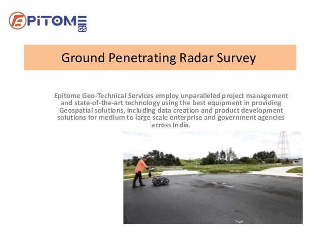
- 1. Ground Penetrating Radar Survey Epitome Geo-Technical Services employ unparalleled project management and state-of-the-art technology using the best equipment in providing Geospatial solutions, including data creation and product development solutions for medium to large scale enterprise and government agencies across India.
- 2. Ground Penetrating Radar Survey EpitomeGS is a Ground Penetrating Radar Survey company in India. Our Services are GPR, SUE, Underground Utility, Underground Scanning & Mapping survey in India.
- 3. GPR METHOD Ground Penetrating Radar operates by transmitting high- frequency radio waves pulses down into the ground through an antenna.
- 4. Geographic Information System Mapping Geographic Information System is a computer-based framework that stores analyze and manages the data. Based on the science of geography, GIS integrates various types of data.
- 5. GIS Mapping GIS uncovers deeper insights into the data such as situations, patterns, and relationships, helping the users to make smarter decisions.
- 6. Contact Us Address: 205, H73, H Block, Sector 63, Noida, Uttar Pradesh Phone: +91-96756 94400 Email: info@epitomegs.com Visit Our Website: https://epitomegs.com