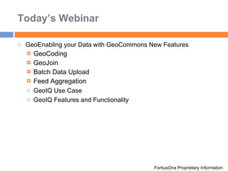
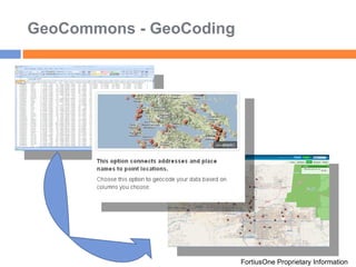
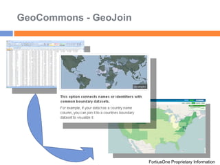
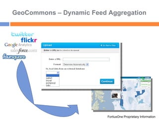
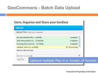
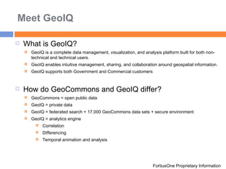
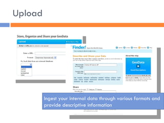
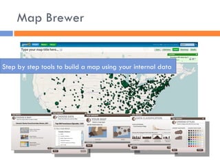
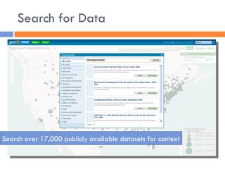
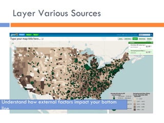
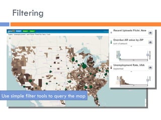
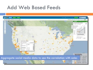
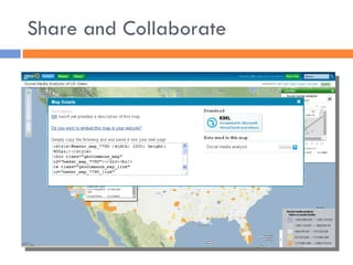
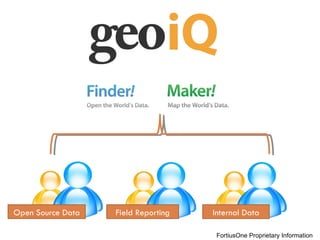
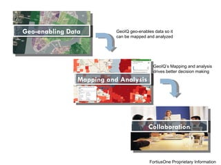
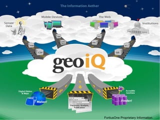
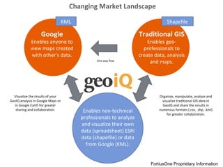
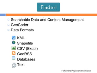
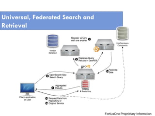
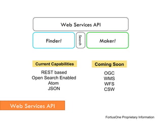
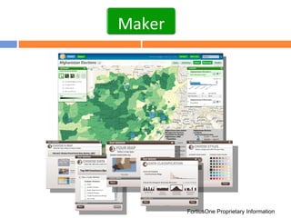
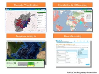
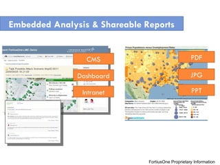
Sean Gorman CEO and Founder [email_address] 703.247.9280 Location Based Analytics
Today’s Webinar GeoEnabling your Data with GeoCommons New Features  GeoCoding GeoJoin Batch Data Upload Feed Aggregation GeoIQ Use Case GeoIQ Features and Functionality FortiusOne Proprietary Information
GeoEnabling Data Easily FortiusOne Proprietary Information Simple queues to get your data on the maps
GeoCommons - GeoCoding FortiusOne Proprietary Information
GeoCommons - GeoJoin FortiusOne Proprietary Information
GeoCommons – Dynamic Feed Aggregation FortiusOne Proprietary Information
GeoCommons - Batch Data Upload FortiusOne Proprietary Information Upload multiple files in a variety of formats
Meet GeoIQ FortiusOne Proprietary Information What is GeoIQ? GeoIQ is a complete data management, visualization, and analysis platform built for both non-technical and technical users.  GeoIQ enables intuitive management, sharing, and collaboration around geospatial information.  GeoIQ supports both Government and Commercial customers How do GeoCommons and GeoIQ differ? GeoCommons = open public data  GeoIQ = private data GeoIQ = federated search + 17,000 GeoCommons data sets + secure environment GeoIQ = analytics engine Correlation  Differencing  Temporal animation and analysis
GEOIQ USE CASE
Upload Ingest your internal data through various formats and provide descriptive information
Map Brewer Step by step tools to build a map using your internal data
Search for Data Search over 17,000 publicly available datasets for context
Layer Various Sources Understand how external factors impact your bottom line
Filtering Use simple filter tools to query the map
Add Web Based Feeds Aggregate social media data to see the correlation with sales
Share and Collaborate
Open Source Data Internal Data Field Reporting FortiusOne Proprietary Information
Geo-enabling Data Mapping and Analysis Collaboration GeoIQ geo-enables data so it can be mapped and analyzed GeoIQ’s Mapping and analysis drives better decision making FortiusOne Proprietary Information
FortiusOne Proprietary Information
Google Enables anyone to view maps created with other’s data. Traditional GIS Enables geo-professionals to create data, analysis and maps. Enables non-technical professionals to analyze and visualize their own data (spreadsheet) ESRI data (shapefile) or data from Google (KML). Changing Market Landscape Organize, manipulate, analyze and visualize traditional GIS data in GeoIQ and share the results in numerous formats (.csv, .shp, .kml) for greater collaboration. Visualize the results of your GeoIQ analysis in Google Maps or in Google Earth for greater sharing and collaboration. One way flow Shapefile KML FortiusOne Proprietary Information
Searchable Data and Content Management GeoCoder Data Formats FortiusOne Proprietary Information Finder! KML Shapefile CSV (Excel) GeoRSS Databases Text
Universal, Federated Search and Retrieval FortiusOne Proprietary Information
FortiusOne Proprietary Information Web Services API Finder ! Maker ! Web Services API Search REST based Open Search Enabled Atom  JSON OGC WMS WFS CSW Current Capabilities Coming Soon
FortiusOne Proprietary Information Maker!
Temporal Analysis Thematic Visualization Correlation & Differencing Georeferencing FortiusOne Proprietary Information
Embedded Analysis & Shareable Reports CMS Dashboard Intranet PDF JPG PPT FortiusOne Proprietary Information
Google 3D Imagery FortiusOne Proprietary Information
Private dashboards with custom data
Easy administration – no coding! Secure login and access controls
For Commercial inquiries, contact Charlie Kiser or Michael Eckert charlie.kiser@fortiusone.com,  703.647.2143 michael.eckert@fortiusone.com,  703.647.2153 For Government inquiries, contact Matt Madigan matt.madigan@fortiusone.com,  703.647.2144 Sean Gorman [email_address] 703.247.9280

FortiusOne Webinar - Intro To GeoIQ

  • 1.
    Sean Gorman CEOand Founder [email_address] 703.247.9280 Location Based Analytics
  • 2.
    Today’s Webinar GeoEnablingyour Data with GeoCommons New Features GeoCoding GeoJoin Batch Data Upload Feed Aggregation GeoIQ Use Case GeoIQ Features and Functionality FortiusOne Proprietary Information
  • 3.
    GeoEnabling Data EasilyFortiusOne Proprietary Information Simple queues to get your data on the maps
  • 4.
    GeoCommons - GeoCodingFortiusOne Proprietary Information
  • 5.
    GeoCommons - GeoJoinFortiusOne Proprietary Information
  • 6.
    GeoCommons – DynamicFeed Aggregation FortiusOne Proprietary Information
  • 7.
    GeoCommons - BatchData Upload FortiusOne Proprietary Information Upload multiple files in a variety of formats
  • 8.
    Meet GeoIQ FortiusOneProprietary Information What is GeoIQ? GeoIQ is a complete data management, visualization, and analysis platform built for both non-technical and technical users. GeoIQ enables intuitive management, sharing, and collaboration around geospatial information. GeoIQ supports both Government and Commercial customers How do GeoCommons and GeoIQ differ? GeoCommons = open public data GeoIQ = private data GeoIQ = federated search + 17,000 GeoCommons data sets + secure environment GeoIQ = analytics engine Correlation Differencing Temporal animation and analysis
  • 9.
  • 10.
    Upload Ingest yourinternal data through various formats and provide descriptive information
  • 11.
    Map Brewer Stepby step tools to build a map using your internal data
  • 12.
    Search for DataSearch over 17,000 publicly available datasets for context
  • 13.
    Layer Various SourcesUnderstand how external factors impact your bottom line
  • 14.
    Filtering Use simplefilter tools to query the map
  • 15.
    Add Web BasedFeeds Aggregate social media data to see the correlation with sales
  • 16.
  • 17.
    Open Source DataInternal Data Field Reporting FortiusOne Proprietary Information
  • 18.
    Geo-enabling Data Mappingand Analysis Collaboration GeoIQ geo-enables data so it can be mapped and analyzed GeoIQ’s Mapping and analysis drives better decision making FortiusOne Proprietary Information
  • 19.
  • 20.
    Google Enables anyoneto view maps created with other’s data. Traditional GIS Enables geo-professionals to create data, analysis and maps. Enables non-technical professionals to analyze and visualize their own data (spreadsheet) ESRI data (shapefile) or data from Google (KML). Changing Market Landscape Organize, manipulate, analyze and visualize traditional GIS data in GeoIQ and share the results in numerous formats (.csv, .shp, .kml) for greater collaboration. Visualize the results of your GeoIQ analysis in Google Maps or in Google Earth for greater sharing and collaboration. One way flow Shapefile KML FortiusOne Proprietary Information
  • 21.
    Searchable Data andContent Management GeoCoder Data Formats FortiusOne Proprietary Information Finder! KML Shapefile CSV (Excel) GeoRSS Databases Text
  • 22.
    Universal, Federated Searchand Retrieval FortiusOne Proprietary Information
  • 23.
    FortiusOne Proprietary InformationWeb Services API Finder ! Maker ! Web Services API Search REST based Open Search Enabled Atom JSON OGC WMS WFS CSW Current Capabilities Coming Soon
  • 24.
  • 25.
    Temporal Analysis ThematicVisualization Correlation & Differencing Georeferencing FortiusOne Proprietary Information
  • 26.
    Embedded Analysis &Shareable Reports CMS Dashboard Intranet PDF JPG PPT FortiusOne Proprietary Information
  • 27.
    Google 3D ImageryFortiusOne Proprietary Information
  • 28.
  • 29.
    Easy administration –no coding! Secure login and access controls
  • 30.
    For Commercial inquiries,contact Charlie Kiser or Michael Eckert charlie.kiser@fortiusone.com, 703.647.2143 michael.eckert@fortiusone.com, 703.647.2153 For Government inquiries, contact Matt Madigan matt.madigan@fortiusone.com, 703.647.2144 Sean Gorman [email_address] 703.247.9280

Editor's Notes

  • #23 Data that is in a system isn’t useful if you can’t find it – or if it’s on some other system. GeoIQ Enterprise can search and retrieve data from other appliances, GeoCommons Community, or hundreds of other data repositories. Don’t keep all your data in a centralized system – but push it to all your centers and provide it at your users fingertips