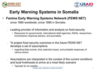
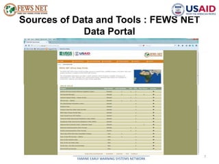
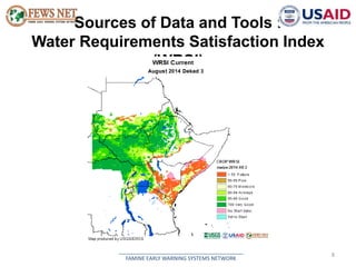
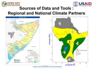
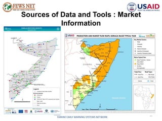
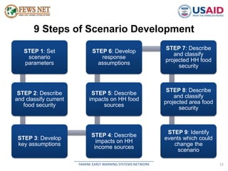
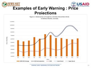
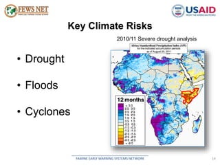
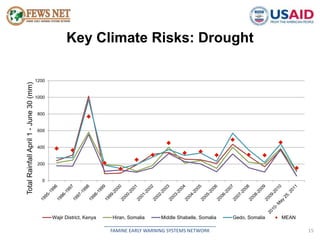
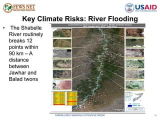
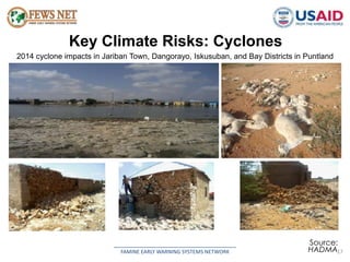
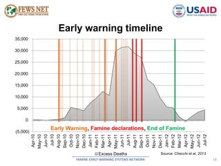
Famine Early Warning Systems Network 
Early Warning Systems in Somalia 
& Key Climate Risks 
2nd Arab Conference on Disaster Risk Reduction 
Sharm-el-Sheikh, Egypt, 14-16 September 2014 
and 
Humanitarian Partnership Conference - Nairobi 
16th - 18th September 2014
Presentation Outline 
• Early warning systems in Somalia 
• Key climate risks faced in Somalia 
__________________________________________ 
FAMINE EARLY WARNING SYSTEMS NETWORK 1
Early Warning Systems in Somalia 
• Famine Early Warning Systems Network (FEWS NET) 
o since 1985 worldwide, since 1995 in Somalia 
o Leading provider of information and analysis on food security 
• Resources for governments, international relief agencies, NGOs, researchers, 
humanitarian response planers, and journalists 
o To project food security outcomes in the future FEWS NET 
develops a set of assumptions 
• regarding likely events, their potential impact, and probable responses of 
__________________________________________ 
FAMINE EARLY WARNING SYSTEMS NETWORK 2 
various actors 
o Assumptions are interpreted in the context of the current conditions 
and local livelihoods to arrive at a most likely scenario 
• Typically for six months
Early Warning Systems in Somalia 
Other information collection bodies in Somalia and FEWS NET’s 
partners 
o Food Security and Nutrition Analysis Unit (FSNAU) 
• A project managed by Food and Agriculture Organization (FAO) 
• A primary source for information on food security, nutrition, and livelihoods in 
__________________________________________ 
FAMINE EARLY WARNING SYSTEMS NETWORK 3 
Somalia 
o Somalia Water and Land Information Management (SWALIM) 
• an information management unit within FAO Somalia focusing on water and 
rainfall 
o Somalia Resilience Program (SomRep) 
• A multi-year effort by seven leading NGOs (World Vision, Oxfam, DRC, 
COOPI, CARE, ADRA, and ACF) 
• Designed to tackle the challenge of recurrent droughts and reduce chronic 
vulnerability through early action
Early Warning Systems in Somalia 
National disaster management agencies 
o National Environment Research and Disaster 
Preparedness and Management Authority (NERAD) in 
Somaliland 
o Humanitarian Affairs and Disaster Management Agency 
(HADMA) in Puntland 
o Somali Disaster Management Agency (SDMA) in South- 
__________________________________________ 
FAMINE EARLY WARNING SYSTEMS NETWORK 4 
Central Somalia
Sources of Data and Tools : Livelihoods 
5 
__________________________________________ 
FAMINE EARLY WARNING SYSTEMS NETWORK
Sources of Data and Tools : Remote 
Sensing 
6 
__________________________________________ 
FAMINE EARLY WARNING SYSTEMS NETWORK 
• Mapviewer (USGS) 
• RFE rainfall plots 
http://earlywarning.usgs.gov/fews/mapv 
iewer/ 
CHIRPS – monthly: 
USGS/UCSB-CHG, 
InfraRed unbiased by 
climatology, added 
stations. 1981-present, 
5Km, global 50N-50S, 5 
days total.
Sources of Data and Tools : FEWS NET 
Data Portal 
7 
__________________________________________ 
FAMINE EARLY WARNING SYSTEMS NETWORK
Sources of Data and Tools : 
Water Requirements Satisfaction Index 
(WRSI) 
8 
__________________________________________ 
FAMINE EARLY WARNING SYSTEMS NETWORK
Sources of Data and Tools : 
Regional and National Climate Partners 
9 
__________________________________________ 
FAMINE EARLY WARNING SYSTEMS NETWORK
Sources of Data and Tools : Market 
Information 
10 
__________________________________________ 
FAMINE EARLY WARNING SYSTEMS NETWORK
Sources of Data and Tools : Databases 
11 
__________________________________________ 
FAMINE EARLY WARNING SYSTEMS NETWORK
9 Steps of Scenario Development 
STEP 6: Develop 
response 
assumptions 
STEP 5: Describe 
impacts on HH food 
sources 
__________________________________________ 
FAMINE EARLY WARNING SYSTEMS NETWORK 12 
STEP 1: Set 
scenario 
parameters 
STEP 2: Describe 
and classify current 
food security 
STEP 3: Develop 
key assumptions 
STEP 4: Describe 
impacts on HH 
income sources 
STEP 7: Describe 
and classify 
projected HH food 
security 
STEP 8: Describe 
and classify 
projected area food 
security 
STEP 9: Identify 
events which could 
change the 
scenario
Examples of Early Warning : Price 
Projections 
__________________________________________ 
FAMINE EARLY WARNING SYSTEMS NETWORK 13
Key Climate Risks 
__________________________________________ 
FAMINE EARLY WARNING SYSTEMS NETWORK 14 
• Drought 
• Floods 
• Cyclones 
2010/11 Severe drought analysis
Key Climate Risks: Drought 
__________________________________________ 
FAMINE EARLY WARNING SYSTEMS NETWORK 15 
1200 
1000 
800 
600 
400 
200 
0 
Total Rainfall April 1 - June 30 (mm) 
Wajir District, Kenya Hiran, Somalia Middle Shabelle, Somalia Gedo, Somalia MEAN
Key Climate Risks: River Flooding 
__________________________________________ 
FAMINE EARLY WARNING SYSTEMS NETWORK 16 
• The Shabelle 
River routinely 
breaks 12 
points within 
90 km – A 
distance 
between 
Jawhar and 
Balad twons
Key Climate Risks: Cyclones 
2014 cyclone impacts in Jariban Town, Dangorayo, Iskusuban, and Bay Districts in Puntland 
__________________________________________ 
Source: 
HADMA 
FAMINE EARLY WARNING SYSTEMS NETWORK 17
__________________________________________ 
FAMINE EARLY WARNING SYSTEMS NETWORK 18 
(5,000) 
0 
5,000 
10,000 
15,000 
20,000 
25,000 
30,000 
35,000 
Apr-10 
May-10 
Jun-10 
Jul-10 
Aug-10 
Sep-10 
Oct-10 
Nov-10 
Dec-10 
Jan-11 
Feb-11 
Mar-11 
Apr-11 
May-11 
Jun-11 
Jul-11 
Aug-11 
Sep-11 
Oct-11 
Nov-11 
Dec-11 
Jan-12 
Feb-12 
Mar-12 
Apr-12 
May-12 
Jun-12 
Jul-12 
Excess Deaths 
Early warning timeline 
Source: Checchi et al, 2013 
Early Warning, Famine declarations, End of Famine
Early Warning Products 
__________________________________________ 
FAMINE EARLY WARNING SYSTEMS NETWORK 19

Early warning systems Somalia & Key Climate Risks

  • 1.
    Famine Early WarningSystems Network Early Warning Systems in Somalia & Key Climate Risks 2nd Arab Conference on Disaster Risk Reduction Sharm-el-Sheikh, Egypt, 14-16 September 2014 and Humanitarian Partnership Conference - Nairobi 16th - 18th September 2014
  • 2.
    Presentation Outline •Early warning systems in Somalia • Key climate risks faced in Somalia __________________________________________ FAMINE EARLY WARNING SYSTEMS NETWORK 1
  • 3.
    Early Warning Systemsin Somalia • Famine Early Warning Systems Network (FEWS NET) o since 1985 worldwide, since 1995 in Somalia o Leading provider of information and analysis on food security • Resources for governments, international relief agencies, NGOs, researchers, humanitarian response planers, and journalists o To project food security outcomes in the future FEWS NET develops a set of assumptions • regarding likely events, their potential impact, and probable responses of __________________________________________ FAMINE EARLY WARNING SYSTEMS NETWORK 2 various actors o Assumptions are interpreted in the context of the current conditions and local livelihoods to arrive at a most likely scenario • Typically for six months
  • 4.
    Early Warning Systemsin Somalia Other information collection bodies in Somalia and FEWS NET’s partners o Food Security and Nutrition Analysis Unit (FSNAU) • A project managed by Food and Agriculture Organization (FAO) • A primary source for information on food security, nutrition, and livelihoods in __________________________________________ FAMINE EARLY WARNING SYSTEMS NETWORK 3 Somalia o Somalia Water and Land Information Management (SWALIM) • an information management unit within FAO Somalia focusing on water and rainfall o Somalia Resilience Program (SomRep) • A multi-year effort by seven leading NGOs (World Vision, Oxfam, DRC, COOPI, CARE, ADRA, and ACF) • Designed to tackle the challenge of recurrent droughts and reduce chronic vulnerability through early action
  • 5.
    Early Warning Systemsin Somalia National disaster management agencies o National Environment Research and Disaster Preparedness and Management Authority (NERAD) in Somaliland o Humanitarian Affairs and Disaster Management Agency (HADMA) in Puntland o Somali Disaster Management Agency (SDMA) in South- __________________________________________ FAMINE EARLY WARNING SYSTEMS NETWORK 4 Central Somalia
  • 6.
    Sources of Dataand Tools : Livelihoods 5 __________________________________________ FAMINE EARLY WARNING SYSTEMS NETWORK
  • 7.
    Sources of Dataand Tools : Remote Sensing 6 __________________________________________ FAMINE EARLY WARNING SYSTEMS NETWORK • Mapviewer (USGS) • RFE rainfall plots http://earlywarning.usgs.gov/fews/mapv iewer/ CHIRPS – monthly: USGS/UCSB-CHG, InfraRed unbiased by climatology, added stations. 1981-present, 5Km, global 50N-50S, 5 days total.
  • 8.
    Sources of Dataand Tools : FEWS NET Data Portal 7 __________________________________________ FAMINE EARLY WARNING SYSTEMS NETWORK
  • 9.
    Sources of Dataand Tools : Water Requirements Satisfaction Index (WRSI) 8 __________________________________________ FAMINE EARLY WARNING SYSTEMS NETWORK
  • 10.
    Sources of Dataand Tools : Regional and National Climate Partners 9 __________________________________________ FAMINE EARLY WARNING SYSTEMS NETWORK
  • 11.
    Sources of Dataand Tools : Market Information 10 __________________________________________ FAMINE EARLY WARNING SYSTEMS NETWORK
  • 12.
    Sources of Dataand Tools : Databases 11 __________________________________________ FAMINE EARLY WARNING SYSTEMS NETWORK
  • 13.
    9 Steps ofScenario Development STEP 6: Develop response assumptions STEP 5: Describe impacts on HH food sources __________________________________________ FAMINE EARLY WARNING SYSTEMS NETWORK 12 STEP 1: Set scenario parameters STEP 2: Describe and classify current food security STEP 3: Develop key assumptions STEP 4: Describe impacts on HH income sources STEP 7: Describe and classify projected HH food security STEP 8: Describe and classify projected area food security STEP 9: Identify events which could change the scenario
  • 14.
    Examples of EarlyWarning : Price Projections __________________________________________ FAMINE EARLY WARNING SYSTEMS NETWORK 13
  • 15.
    Key Climate Risks __________________________________________ FAMINE EARLY WARNING SYSTEMS NETWORK 14 • Drought • Floods • Cyclones 2010/11 Severe drought analysis
  • 16.
    Key Climate Risks:Drought __________________________________________ FAMINE EARLY WARNING SYSTEMS NETWORK 15 1200 1000 800 600 400 200 0 Total Rainfall April 1 - June 30 (mm) Wajir District, Kenya Hiran, Somalia Middle Shabelle, Somalia Gedo, Somalia MEAN
  • 17.
    Key Climate Risks:River Flooding __________________________________________ FAMINE EARLY WARNING SYSTEMS NETWORK 16 • The Shabelle River routinely breaks 12 points within 90 km – A distance between Jawhar and Balad twons
  • 18.
    Key Climate Risks:Cyclones 2014 cyclone impacts in Jariban Town, Dangorayo, Iskusuban, and Bay Districts in Puntland __________________________________________ Source: HADMA FAMINE EARLY WARNING SYSTEMS NETWORK 17
  • 19.
    __________________________________________ FAMINE EARLYWARNING SYSTEMS NETWORK 18 (5,000) 0 5,000 10,000 15,000 20,000 25,000 30,000 35,000 Apr-10 May-10 Jun-10 Jul-10 Aug-10 Sep-10 Oct-10 Nov-10 Dec-10 Jan-11 Feb-11 Mar-11 Apr-11 May-11 Jun-11 Jul-11 Aug-11 Sep-11 Oct-11 Nov-11 Dec-11 Jan-12 Feb-12 Mar-12 Apr-12 May-12 Jun-12 Jul-12 Excess Deaths Early warning timeline Source: Checchi et al, 2013 Early Warning, Famine declarations, End of Famine
  • 20.
    Early Warning Products __________________________________________ FAMINE EARLY WARNING SYSTEMS NETWORK 19