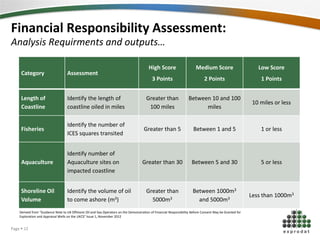
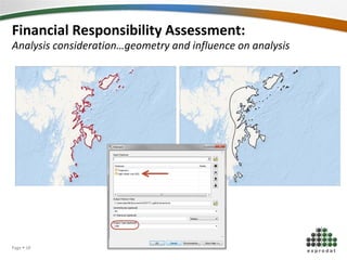
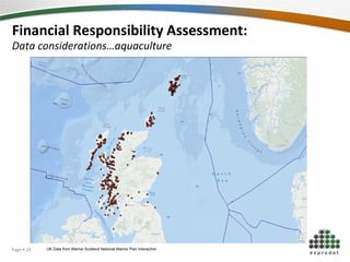
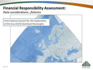
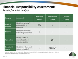
Using ArcGIS to increase productivity and
accuracy in meeting oil spill planning and
mitigation
Simon Kettle – Exprodat Consulting Ltd. Adam Jones – Environmental Manager
Summary
Introduction
GIS Application to DECC Legislation
Financial Responsibility Analysis
Conclusions
1
2
3
4
5
The Environmental Process
Page  2
Introduction
• Start of a GIS for Environment
• GIS is becoming an important
tool
• Viewing
• Analysing
• Integrating
• Sharing
Image from: http://news.bbc.co.uk/1/hi/scotland/8486571.stm
Page  3
Objectives
• Identify areas for GIS in
Environment
• Deployment of GIS data
• Workflows
• Improve workflow efficiency
• Development of tools
• Production of easily accessible GIS maps and
data
Improve
workflows
Increase
Accuracy
Maximise
Efficiency
Page  4
The Environmental Process
Planning and
Preparation
Monitoring
Oil and
Chemical Spill
response
Decommissioning
Petroleum Operation Notifications (PON)
Page  5
Planning and Preparation:
Environmental Impact Assessment
An assessment of the possible impacts that a proposed project may have on the
environment.
Consent to
Drill Well
Oil Pollution
Emergency Plan
(OPEP)
Financial
Responsibility
Assessment
Chemical Permit
Application
Environmental
Statement
Environment
Impact
Assessment (EIA)
Page  6
Environmental Impact Assessment:
GIS and applying for Petroleum Operations
DECC
Environmental
Regulations 1999
Required within
distances :
Fisheries Coastlines
Protected Areas
Transport Routes
Areas of Seismic
Sensitivity
Coull, K.A., Johnstone, R., and S.I. Rogers. 1998.
Fisheries Sensitivity Maps in British Waters. Published
and distributed by UKOOA Ltd.
Ellis, J.R., Milligan, S.P., Readdy, L., Taylor, N. and Brown,
M.J. 2012. Spawning and nursery grounds of selected fish
species in UK waters. Sci. Ser. Tech. Rep., Cefas
Lowestoft, 147: 56 pp.
Page  7
Environmental Impact Assessment:
GIS and applying for Petroleum Operations
DECC
Environmental
Regulations 1999
Required within
distances :
Fisheries Coastlines
Protected Areas
Transport Routes
Areas of Seismic
Sensitivity
Coull, K.A., Johnstone, R., and S.I. Rogers. 1998.
Fisheries Sensitivity Maps in British Waters. Published
and distributed by UKOOA Ltd.
Ellis, J.R., Milligan, S.P., Readdy, L., Taylor, N. and Brown,
M.J. 2012. Spawning and nursery grounds of selected fish
species in UK waters. Sci. Ser. Tech. Rep., Cefas
Lowestoft, 147: 56 pp.
Page  8
Environmental Impact Assessment:
GIS and applying for Petroleum Operations
DECC
Environmental
Regulations 1999
Required within
distances :
Fisheries Coastlines
Protected Areas
Transport Routes
Areas of Seismic
Sensitivity
Coull, K.A., Johnstone, R., and S.I. Rogers. 1998.
Fisheries Sensitivity Maps in British Waters. Published
and distributed by UKOOA Ltd.
Ellis, J.R., Milligan, S.P., Readdy, L., Taylor, N. and Brown,
M.J. 2012. Spawning and nursery grounds of selected fish
species in UK waters. Sci. Ser. Tech. Rep., Cefas
Lowestoft, 147: 56 pp.
Page  9
Planning and Preparation:
Financial Responsibility Assessment
The assurance that operators and co-ventures have the financial resources to respond,
control and compensate for any unintended and uncontrolled release of hydrocarbons
from a well.
Consent to
Drill Well
Oil Pollution
Emergency Plan
(OPEP)
Financial
Responsibility
Assessment
Chemical Permit
Application
Environmental
Statement
Environment
Impact
Assessment (EIA)
Page  10
Financial Responsibility Assessment:
Process
Complete Modelling
work for OPEP (e.g.
OSCAR, OILMAP,
OSIS)
Use modelling
outputs to determine
the risk band for the
well
Operator submits
calculations
Operator collects all
data and sums the
total Financial
Requirement needed
Page  11
Financial Responsibility Assessment:
Analysis Requirments and outputs…
Category Assessment
High Score
3 Points
Medium Score
2 Points
Low Score
1 Points
Length of
Coastline
Identify the length of
coastline oiled in miles
Greater than
100 miles
Between 10 and 100
miles
10 miles or less
Fisheries
Identify the number of
ICES squares transited
Greater than 5 Between 1 and 5 1 or less
Aquaculture
Identify number of
Aquaculture sites on
impacted coastline
Greater than 30 Between 5 and 30 5 or less
Shoreline Oil
Volume
Identify the volume of oil
to come ashore (m3)
Greater than
5000m3
Between 1000m3
and 5000m3
Less than 1000m3
Derived from “Guidance Note to UK Offshore Oil and Gas Operators on the Demonstration of Financial Responsibility Before Consent May be Granted for
Exploration and Appraisal Wells on the UKCS” Issue 1, November 2012
Page  12
Financial Responsibility Assessment:
Requirements…
Data
Coastline polygon, ICES Rectangles, Trajectory polygon, Well Location,
Oil Volume, Aquaculture Sites
Analysis Applications
4 key analyses, Accuracy and Precision
Analysis Considerations
Length of Coastline, Number of ICES Rectangles, Aquaculture and Oil
volume
Page  13
Financial Responsibility Assessment:
Analysis considerations…coordinate reference systems
Page  14
Financial Responsibility Assessment:
Analysis considerations…coordinate reference systems
Page  15
Financial Responsibility Assessment:
Analysis considerations…coordinate reference systems
Page  16
Financial Responsibility Assessment:
Data consideration…trajectory accuracy
Page  17
Financial Responsibility Assessment:
Analysis consideration…geometry and influence on analysis
Page  18
Financial Responsibility Assessment:
Analysis consideration…coastline intersection
304 Km
Page  19
Financial Responsibility Assessment:
Analysis presentation…precision
Page  20
Financial Responsibility Assessment:
Analysis presentation…precision
Page  21
Financial Responsibility Assessment:
Analysis presentation…precision
Page  22
Financial Responsibility Assessment:
Data considerations…aquaculture
UK Data from Marine Scotland National Marine Plan InteractivePage  23
Financial Responsibility Assessment:
Data considerations…aquaculture
UK Data from Marine Scotland National Marine Plan InteractivePage  24
Financial Responsibility Assessment:
Analysis considerations…aquaculture
26 sites
Page  25
Financial Responsibility Assessment:
Data considerations…fisheries
International Council for the Exploration
of the Sea (ICES) Statistical Rectangles
Page  26
Financial Responsibility Assessment:
Analysis considerations…fisheries
7 Rectangles
Page  27
Financial Responsibility Assessment:
Analysis Requirments and outputs…
Category Assessment
High Score
3 Points
Medium Score
2 Points
Low Score
1 Points
Length of
Coastline
Identify the length of
coastline oiled in miles
Greater than
100 miles
Between 10 and 100
miles
10 miles or less
Fisheries
Identify the number of
ICES squares transited
Greater than 5 Between 1 and 5 1 or less
Aquaculture
Identify number of
Aquaculture sites on
impacted coastline
Greater than 30 Between 5 and 30 5 or less
Shoreline Oil
Volume
Identify the volume of oil
to come ashore (m3)
Greater than
5000m3
Between 1000m3
and 5000m3
Less than 1000m3
Derived from “Guidance Note to UK Offshore Oil and Gas Operators on the Demonstration of Financial Responsibility Before Consent May be Granted for
Exploration and Appraisal Wells on the UKCS” Issue 1, November 2012
Page  28
Financial Responsibility Assessment:
Results from this analysis
Category Assessment
High Score
3 Points
Medium Score
2 Points
Low Score
1 Points
Length of
Coastline
Identify the length of
coastline oiled in
kilometres
304 - -
Fisheries
Identify the number of
ICES rectangles transited
7 - -
Aquaculture
Identify number of
Aquaculture sites on
impacted coastline
- 26 -
Shoreline Oil
Volume
Identify the volume of oil
to come ashore (m3)
- 2,000m3 -
Derived from “Guidance Note to UK Offshore Oil and Gas Operators on the Demonstration of Financial Responsibility Before Consent May be Granted for
Exploration and Appraisal Wells on the UKCS” Issue 1, November 2012
Page  29
Financial Responsibility Assessment:
Resulting Score
Scores added
together
Banding FR Recommended (100% interest in well)
Exempt well category None Not considered necessary
5 or less 1
US $250m – financial responsibility demonstrated by the
operator to OPOL
6 or 7 2
US $375m (US $125m to address legal liability for pollution
remediation and compensation in addition to financial
responsibility demonstrated by the operator to OPOL)
8 or 9 3
US $500m (US $250m to address legal liability for pollution
remediation and compensation in addition to financial
responsibility demonstrated by the operator to OPOL)
10 - 12 4
US $750m (recommendation to demonstrate US $500m to
address legal liability for pollution remediation and
compensation in addition to financial responsibility
demonstrated by the operator to OPOL)
Derived from “Guidance Note to UK Offshore Oil and Gas Operators on the Demonstration of Financial Responsibility Before Consent May be Granted for
Exploration and Appraisal Wells on the UKCS” Issue 1, November 2012
Page  30
Financial Responsibility Assessment:
GIS Process
• Work time reduced from 4 hours to
< 5 minutes
• 98 % decrease in time spent on
process
Page  31
Financial Responsibility Assessment:
GIS Process
• Work time reduced from 4 hours to
5 minutes
• 98 % decrease in time spent on
process
Page  32
Other Areas of potential GIS use:
Preparation and Planning
Geological and Seismic Surveys
• Habitat Impact Directive, EIA, Fisheries Impact
Well Test
• Environmental Statement, OPEP
Offshore Pipeline Construction
• Environmental Statement, EIA, Fisheries Impacts, Habitat Impact
Directive
Workover, Offshore Waste Storage and Transfer, Well
Suspension, Well Abandonment
Page  33
Q & AQuestions & Answers
Page  34
Page  35
GIS Consulting GIS Software GIS Training
Thank You!
Follow Exprodat
Page  35
Simon Kettle – skettle@exprodat.com

epug_33

  • 1.
    Using ArcGIS toincrease productivity and accuracy in meeting oil spill planning and mitigation Simon Kettle – Exprodat Consulting Ltd. Adam Jones – Environmental Manager
  • 2.
    Summary Introduction GIS Application toDECC Legislation Financial Responsibility Analysis Conclusions 1 2 3 4 5 The Environmental Process Page  2
  • 3.
    Introduction • Start ofa GIS for Environment • GIS is becoming an important tool • Viewing • Analysing • Integrating • Sharing Image from: http://news.bbc.co.uk/1/hi/scotland/8486571.stm Page  3
  • 4.
    Objectives • Identify areasfor GIS in Environment • Deployment of GIS data • Workflows • Improve workflow efficiency • Development of tools • Production of easily accessible GIS maps and data Improve workflows Increase Accuracy Maximise Efficiency Page  4
  • 5.
    The Environmental Process Planningand Preparation Monitoring Oil and Chemical Spill response Decommissioning Petroleum Operation Notifications (PON) Page  5
  • 6.
    Planning and Preparation: EnvironmentalImpact Assessment An assessment of the possible impacts that a proposed project may have on the environment. Consent to Drill Well Oil Pollution Emergency Plan (OPEP) Financial Responsibility Assessment Chemical Permit Application Environmental Statement Environment Impact Assessment (EIA) Page  6
  • 7.
    Environmental Impact Assessment: GISand applying for Petroleum Operations DECC Environmental Regulations 1999 Required within distances : Fisheries Coastlines Protected Areas Transport Routes Areas of Seismic Sensitivity Coull, K.A., Johnstone, R., and S.I. Rogers. 1998. Fisheries Sensitivity Maps in British Waters. Published and distributed by UKOOA Ltd. Ellis, J.R., Milligan, S.P., Readdy, L., Taylor, N. and Brown, M.J. 2012. Spawning and nursery grounds of selected fish species in UK waters. Sci. Ser. Tech. Rep., Cefas Lowestoft, 147: 56 pp. Page  7
  • 8.
    Environmental Impact Assessment: GISand applying for Petroleum Operations DECC Environmental Regulations 1999 Required within distances : Fisheries Coastlines Protected Areas Transport Routes Areas of Seismic Sensitivity Coull, K.A., Johnstone, R., and S.I. Rogers. 1998. Fisheries Sensitivity Maps in British Waters. Published and distributed by UKOOA Ltd. Ellis, J.R., Milligan, S.P., Readdy, L., Taylor, N. and Brown, M.J. 2012. Spawning and nursery grounds of selected fish species in UK waters. Sci. Ser. Tech. Rep., Cefas Lowestoft, 147: 56 pp. Page  8
  • 9.
    Environmental Impact Assessment: GISand applying for Petroleum Operations DECC Environmental Regulations 1999 Required within distances : Fisheries Coastlines Protected Areas Transport Routes Areas of Seismic Sensitivity Coull, K.A., Johnstone, R., and S.I. Rogers. 1998. Fisheries Sensitivity Maps in British Waters. Published and distributed by UKOOA Ltd. Ellis, J.R., Milligan, S.P., Readdy, L., Taylor, N. and Brown, M.J. 2012. Spawning and nursery grounds of selected fish species in UK waters. Sci. Ser. Tech. Rep., Cefas Lowestoft, 147: 56 pp. Page  9
  • 10.
    Planning and Preparation: FinancialResponsibility Assessment The assurance that operators and co-ventures have the financial resources to respond, control and compensate for any unintended and uncontrolled release of hydrocarbons from a well. Consent to Drill Well Oil Pollution Emergency Plan (OPEP) Financial Responsibility Assessment Chemical Permit Application Environmental Statement Environment Impact Assessment (EIA) Page  10
  • 11.
    Financial Responsibility Assessment: Process CompleteModelling work for OPEP (e.g. OSCAR, OILMAP, OSIS) Use modelling outputs to determine the risk band for the well Operator submits calculations Operator collects all data and sums the total Financial Requirement needed Page  11
  • 12.
    Financial Responsibility Assessment: AnalysisRequirments and outputs… Category Assessment High Score 3 Points Medium Score 2 Points Low Score 1 Points Length of Coastline Identify the length of coastline oiled in miles Greater than 100 miles Between 10 and 100 miles 10 miles or less Fisheries Identify the number of ICES squares transited Greater than 5 Between 1 and 5 1 or less Aquaculture Identify number of Aquaculture sites on impacted coastline Greater than 30 Between 5 and 30 5 or less Shoreline Oil Volume Identify the volume of oil to come ashore (m3) Greater than 5000m3 Between 1000m3 and 5000m3 Less than 1000m3 Derived from “Guidance Note to UK Offshore Oil and Gas Operators on the Demonstration of Financial Responsibility Before Consent May be Granted for Exploration and Appraisal Wells on the UKCS” Issue 1, November 2012 Page  12
  • 13.
    Financial Responsibility Assessment: Requirements… Data Coastlinepolygon, ICES Rectangles, Trajectory polygon, Well Location, Oil Volume, Aquaculture Sites Analysis Applications 4 key analyses, Accuracy and Precision Analysis Considerations Length of Coastline, Number of ICES Rectangles, Aquaculture and Oil volume Page  13
  • 14.
    Financial Responsibility Assessment: Analysisconsiderations…coordinate reference systems Page  14
  • 15.
    Financial Responsibility Assessment: Analysisconsiderations…coordinate reference systems Page  15
  • 16.
    Financial Responsibility Assessment: Analysisconsiderations…coordinate reference systems Page  16
  • 17.
    Financial Responsibility Assessment: Dataconsideration…trajectory accuracy Page  17
  • 18.
    Financial Responsibility Assessment: Analysisconsideration…geometry and influence on analysis Page  18
  • 19.
    Financial Responsibility Assessment: Analysisconsideration…coastline intersection 304 Km Page  19
  • 20.
    Financial Responsibility Assessment: Analysispresentation…precision Page  20
  • 21.
    Financial Responsibility Assessment: Analysispresentation…precision Page  21
  • 22.
    Financial Responsibility Assessment: Analysispresentation…precision Page  22
  • 23.
    Financial Responsibility Assessment: Dataconsiderations…aquaculture UK Data from Marine Scotland National Marine Plan InteractivePage  23
  • 24.
    Financial Responsibility Assessment: Dataconsiderations…aquaculture UK Data from Marine Scotland National Marine Plan InteractivePage  24
  • 25.
    Financial Responsibility Assessment: Analysisconsiderations…aquaculture 26 sites Page  25
  • 26.
    Financial Responsibility Assessment: Dataconsiderations…fisheries International Council for the Exploration of the Sea (ICES) Statistical Rectangles Page  26
  • 27.
    Financial Responsibility Assessment: Analysisconsiderations…fisheries 7 Rectangles Page  27
  • 28.
    Financial Responsibility Assessment: AnalysisRequirments and outputs… Category Assessment High Score 3 Points Medium Score 2 Points Low Score 1 Points Length of Coastline Identify the length of coastline oiled in miles Greater than 100 miles Between 10 and 100 miles 10 miles or less Fisheries Identify the number of ICES squares transited Greater than 5 Between 1 and 5 1 or less Aquaculture Identify number of Aquaculture sites on impacted coastline Greater than 30 Between 5 and 30 5 or less Shoreline Oil Volume Identify the volume of oil to come ashore (m3) Greater than 5000m3 Between 1000m3 and 5000m3 Less than 1000m3 Derived from “Guidance Note to UK Offshore Oil and Gas Operators on the Demonstration of Financial Responsibility Before Consent May be Granted for Exploration and Appraisal Wells on the UKCS” Issue 1, November 2012 Page  28
  • 29.
    Financial Responsibility Assessment: Resultsfrom this analysis Category Assessment High Score 3 Points Medium Score 2 Points Low Score 1 Points Length of Coastline Identify the length of coastline oiled in kilometres 304 - - Fisheries Identify the number of ICES rectangles transited 7 - - Aquaculture Identify number of Aquaculture sites on impacted coastline - 26 - Shoreline Oil Volume Identify the volume of oil to come ashore (m3) - 2,000m3 - Derived from “Guidance Note to UK Offshore Oil and Gas Operators on the Demonstration of Financial Responsibility Before Consent May be Granted for Exploration and Appraisal Wells on the UKCS” Issue 1, November 2012 Page  29
  • 30.
    Financial Responsibility Assessment: ResultingScore Scores added together Banding FR Recommended (100% interest in well) Exempt well category None Not considered necessary 5 or less 1 US $250m – financial responsibility demonstrated by the operator to OPOL 6 or 7 2 US $375m (US $125m to address legal liability for pollution remediation and compensation in addition to financial responsibility demonstrated by the operator to OPOL) 8 or 9 3 US $500m (US $250m to address legal liability for pollution remediation and compensation in addition to financial responsibility demonstrated by the operator to OPOL) 10 - 12 4 US $750m (recommendation to demonstrate US $500m to address legal liability for pollution remediation and compensation in addition to financial responsibility demonstrated by the operator to OPOL) Derived from “Guidance Note to UK Offshore Oil and Gas Operators on the Demonstration of Financial Responsibility Before Consent May be Granted for Exploration and Appraisal Wells on the UKCS” Issue 1, November 2012 Page  30
  • 31.
    Financial Responsibility Assessment: GISProcess • Work time reduced from 4 hours to < 5 minutes • 98 % decrease in time spent on process Page  31
  • 32.
    Financial Responsibility Assessment: GISProcess • Work time reduced from 4 hours to 5 minutes • 98 % decrease in time spent on process Page  32
  • 33.
    Other Areas ofpotential GIS use: Preparation and Planning Geological and Seismic Surveys • Habitat Impact Directive, EIA, Fisheries Impact Well Test • Environmental Statement, OPEP Offshore Pipeline Construction • Environmental Statement, EIA, Fisheries Impacts, Habitat Impact Directive Workover, Offshore Waste Storage and Transfer, Well Suspension, Well Abandonment Page  33
  • 34.
    Q & AQuestions& Answers Page  34
  • 35.
    Page  35 GISConsulting GIS Software GIS Training Thank You! Follow Exprodat Page  35 Simon Kettle – skettle@exprodat.com