Download to read offline

![28 | P a g e
subject to necessary changes being made in the use-premises/ lay-out plan, by the local
body, within its competence, in terms of Sub clause 8 (2) A of the Master Plan for Delhi 2001
(Page 152 -153 under S.O. 606 (E) in the Gazette of India Extraordinary dated 1.8.1990),
and for this purpose the schools shall be required to apply to the local body concerned.
(ii) In addition, Coaching centres and similar educational institutions, running in residential
premises, shall be allowed to continue till the end of the current academic year or till 18st
May 2007, whichever is earlier.
COMMERCIAL STREETS AND AREAS:
The following streets/ stretches of streets or areas may be notified as Commercial Streets or
Commercial areas by the local authority:
(a) where more than 70% of the plots abutting roads of ROW exceeding 24m, in a stretch of
at least 300m, in regular plotted development are under commercial use, on (provided that
no street in colonies in A and B categories shall be notified as commercial street).
(b) where more than 70% of the properties abutting roads of less width than 24m ROW, in a
stretch of at least 100m, in rehabilitation colonies, Regularized-Unauthorized colonies,
resettlement colonies, Walled City, Special Area and urban Villages and local commercial
streets declared under MPD 1962 as per para 10.3.1; and
(c) In E, F and G category colonies, where, [If] 80% of residential plots are under mixed use,
or if there are 300 shops, within a contiguous area of 1 hectare.
Identification of such streets/ stretches is to be done on the basis of field survey to be
conducted by the local body within a reasonable period of time and with due expedition of
the date of this notification coming into force.
After identification is done, notification of commercial stretches/ streets by the local body/
authority with the approval of the Competent Authority would necessitate compliance to the
following terms and conditions:
i) Preparation of revised lay-out plan/ Scheme for such areas/ streets with the approval of
the local body/ Authority;
ii) The lay-out plan/ Scheme for such areas/ streets should indicate adequate provision for
circulation, parking, open spaces and other planning norms;
iii) Common parking areas would be earmarked taking into account the additional load on
traffic and parking consequent upon notification of the street as commercial area/ street. If
no parking space is available, land/ plot on the said street/ area may be made available by
Traders association, wherever possible, or acquired for construction of parking facilities,
preferably, multi level parking. Development of such parking facilities may be done by either
the traders Association or by local bodies and may include public-private partnership as a
model for implementation.
iv) On notification of a Commercial street/ area under this clause, such streets/ areas shall
be considered as non-hierarchical commercial centres as mentioned in Development Code
in Master Plan 2001. The plot owners / allottees on these commercial streets/ areas shall
have to pay Special conversion charges at rates approved by the Central Government, in
respect of the built up area used for commercial purpose, provided that such built up area
shall not exceed the residential development control norms applicable to the plot. This is
only a one-time facility for plot allottees/ owners in such Commercial areas/ streets and shall
not be construed as relaxation of the development control norms in future.](https://image.slidesharecdn.com/dissertationreportmixedlanduseintourbandevelopment-230306063339-ce7e21d3/85/Dissertation_report_MIXED_LAND_USE_INTO_URBAN_DEVELOPMENT-pdf-28-320.jpg)
![29 | P a g e
v). Any other condition that may be prescribed by Government from time to time. [No.K-
13011/2/2006/DDIB] (S.Mukherjee) Under Secretary to the Government of India
To
The Manager,
Government Printing Press,
Mayapuri, Ring Road
New Delhi.
MIXED USE STREETS IN VARIOUS ZONES OF DELHI
1. Zone ‗A‘ & part ‗C‘ (Walled City)
1. Chandni Chowk road ( 100 ft R/W)
2. Netaji Subhash Marg (80 ft. R/W)
3. Ansari Road (60 ft. R/W)
4. Khari Baoli (80 ft. R/W)
5. Naya Bazar Road (80 ft. R/W)
6. Shardanand Marg (80 ft. R/W)
7. Ajmeri Gate Bazar (60 ft. R/W)
8. Church Mission Road (60 ft. R/W)
9. S.P.M. Marg (120 ft. R/W)
10. H.C Sen Road (100 ft. R/W)
11. Ajmeri Gate Road Bazar Sita Ram, Gali Kucha Pati Ram, Gali Arya Samaj, Gali Kali
Masjid, Gali Katra Anikhan.
12. Bazar Dilli Darwaza
13. Netaji Subhash Marg, Sir Syed Ahmad Marg, Gali Kuncha Chalan, Gali Pataudi House,
Gali Kala Mehal.
14. Gali Churiwalan Chawri Bazar, Bazar Matia Mahal, Sita Ram Bazar, Gali Pandit Prem
Narainh
15. Ajmeri Gate Road, Fasil Road, Gali Shah Tara, Gali Kucha Pandit, Gali Sahaganj
Farashkhana Road, Lal Kuan Bazar.
16. Farash Khana Road, Samosa Wali Gali, Fasil Road, Naya Bans Road, Bazar Khari
Baoli, Katra Dariyan Road, Gali Batashawali, Gali Kucha Nawab.
17. Netaji Subhash Marg, Dayanand Road, Ansari
Road
18. Katra Bariyan Road, Lal Kuan Road, Gali Ballimaran, Gali Kashim Jaan, Chawri Bazar,
Nai Sarak, Chandni Chowk.
19. Nai Sarak, Chandni Chowk Esplanade Road, Dariba Kalan Bazar Gulian, Chawri Bazar,
Chatta Shahji, Gali Khajoor, Gali Katra Kushal Rai, Gali Anar Wali, Kinari Bazar, Maliwara
Road.
20. Chandni Chowk, Katra neel, Church Mission Road, Katra Natwar Area.
21. H.C. Sen Road, Chandni Chowk
22. Bara Bazar Road.
2. Zone – A (Part other than Walled City):
1. Rani Jhanzi Road (Azad Market Chowk to Filmistan)
From crossing with Gaushala Road to Filmistan (On East side)
2. Qutub Road (Singhara Chowk to Pul Mithai)
From junction near Sr. Sec. School Sadar Bazar to Pul Mithai and Western side of the road.
3. Sadar Thana Road Sadar Thana to Phoota Road](https://image.slidesharecdn.com/dissertationreportmixedlanduseintourbandevelopment-230306063339-ce7e21d3/85/Dissertation_report_MIXED_LAND_USE_INTO_URBAN_DEVELOPMENT-pdf-29-320.jpg)
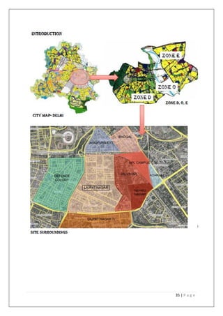

This document is a dissertation report submitted by Roza Pahuja for her Master's degree in Ekistics on mixed land use in urban development. It includes declarations signed by Roza Pahuja and her dissertation guide certifying the original work. It also provides an acknowledgement, characterization of chapters, and introduction outlining the aim, objectives, methodology, and scope of the study. The introduction discusses the evolution of mixed land use and its definition in the context of Delhi. It aims to analyze mixed use development patterns, regulations, and a case study area in Delhi to understand the impacts and potential for mixed use to reduce travel needs.


