![There are three different and generally-accepted approaches
to the Land Suitability Assessment exercise:
•Limitations method [FAO, 1984]
•Parametric method [Sys, 1985]
•Decision trees method [Rossiter, 1986]](https://image.slidesharecdn.com/qexamination-120828112745-phpapp02/75/Desarrollo-del-sistema-LANSAS-13-2048.jpg)


![The membership function defined by Huajun can only be
applied to suitability class S1, therefore two extra
membership functions should be defined for each of all three
suitability classes (S1, S2, S3)
LUT performance
120 0; x ∈ (−∞ , α 1 )
100
2[( x − α 1 ) /(γ − α 1 )] ; x ∈ [α 1 , β 1 )
2
S1 80
60 f 1 ( x; α 1 , β 1 , γ ) =
1 − 2[( x − γ ) /(γ − α 1 )] ; x ∈ [ β 1 , γ )
2
40
20 1; x ∈ [γ , ∞ )
0
19 20 35 50 51
LUT performance 0; x ∈ (−∞, α 1 ) ∨ x ∈ (α 2 , ∞ )
Yield / performance
120
2[( x − α 1 ) /(γ − α 1 )] ; x ∈ [α 1 , β 1 )
2
100
2[( x − α ) /(γ − α )] 2 ; x ∈ ( β , α ]
80
f 2 ( x; α 1 , α 2 , β 1 , β 2 , γ ) = 2 2 2 2
S2 60
40
1 − 2[( x − γ ) /(γ − α 1 )] ; x ∈ [ β 1 , γ )
2
1 − 2[( x − γ ) /(γ − α )] 2 ; x ∈ (γ , β ]
20 2 2
0 1; x = γ
345 325 270 220 185 150 130 110 90
LUT performance 120
0; x ∈ (α 1 , ∞ )
100
2[( x − γ ) /(γ − α 1 )] ; x ∈ ( β 1 ,α 1 ]
2
80
f 3 ( x;α 1 , β 1 , γ ) =
S3 60
40
1 − 2[( x − α 1 ) /(γ − α 1 )] ; x ∈ (γ , β 1 ]
2
1; x = γ
20
0
0 3 15 35 55](https://image.slidesharecdn.com/qexamination-120828112745-phpapp02/75/Desarrollo-del-sistema-LANSAS-37-2048.jpg)


![Land Characteristic Value
Precipitation 1500
Length Growing Period 130
Temperature 33
<500 [500, 1000) [1000, 1500) 1500 (1500, 2000] (2000, 3000]
Precipitation N2 S3 S2 S1 S2 S3
>3000
N2
[100, 150) 150
S2 S1
[50, 100)
S3 Land Characteristic Clas
Length Growing Period
s
Precipitation S1
Length Growing S2
25
S1
Period
Temperature S3
Temperature [22,25) (25, 30]
S2 S2
(30, 35]
S3 Suitability Class S3
>35
N2](https://image.slidesharecdn.com/qexamination-120828112745-phpapp02/75/Desarrollo-del-sistema-LANSAS-60-2048.jpg)


![Land Suitability Assessment based on FNN
θ 2=0
Neuron i,2
in
n
conjunction Layer
Oi , 2 = f1 (∑ X iWi , 2 − θ 2 )
i =1
Wi,2=1 0; xi ∈ (− ∞ ,α 1 )
xi S1
2[( xi − α 1 ) /(γ − α 1 )] ; xi ∈ [α 1 , β 1 )
2
Oi,2
f1 ( xi ;α 1 , β 1 , γ ) =
1 − 2[( xi − γ ) /(γ − α 1 )]2 ; xi ∈ [ β 1 , γ ) Wi,2=1
1; x ∈ [γ , ∞ )
i
Neuron i,1 in Input Fuzzy Layer](https://image.slidesharecdn.com/qexamination-120828112745-phpapp02/75/Desarrollo-del-sistema-LANSAS-75-2048.jpg)


![The computer system will be designed, and developed adopting the
prototyping paradigm from the software engineer perspective.
This is convenient, because the development process time is short,
and it can provide dramatic savings in total software life cycle costs
[Isensee, 1996].
List of List of List of
revisions revisions revisions
Revise User/designer
prototype review
Prototype Prototype Prototype Test
requirements design system
System requirements
(sometimes informal or incomplete)
Delivered system](https://image.slidesharecdn.com/qexamination-120828112745-phpapp02/75/Desarrollo-del-sistema-LANSAS-83-2048.jpg)


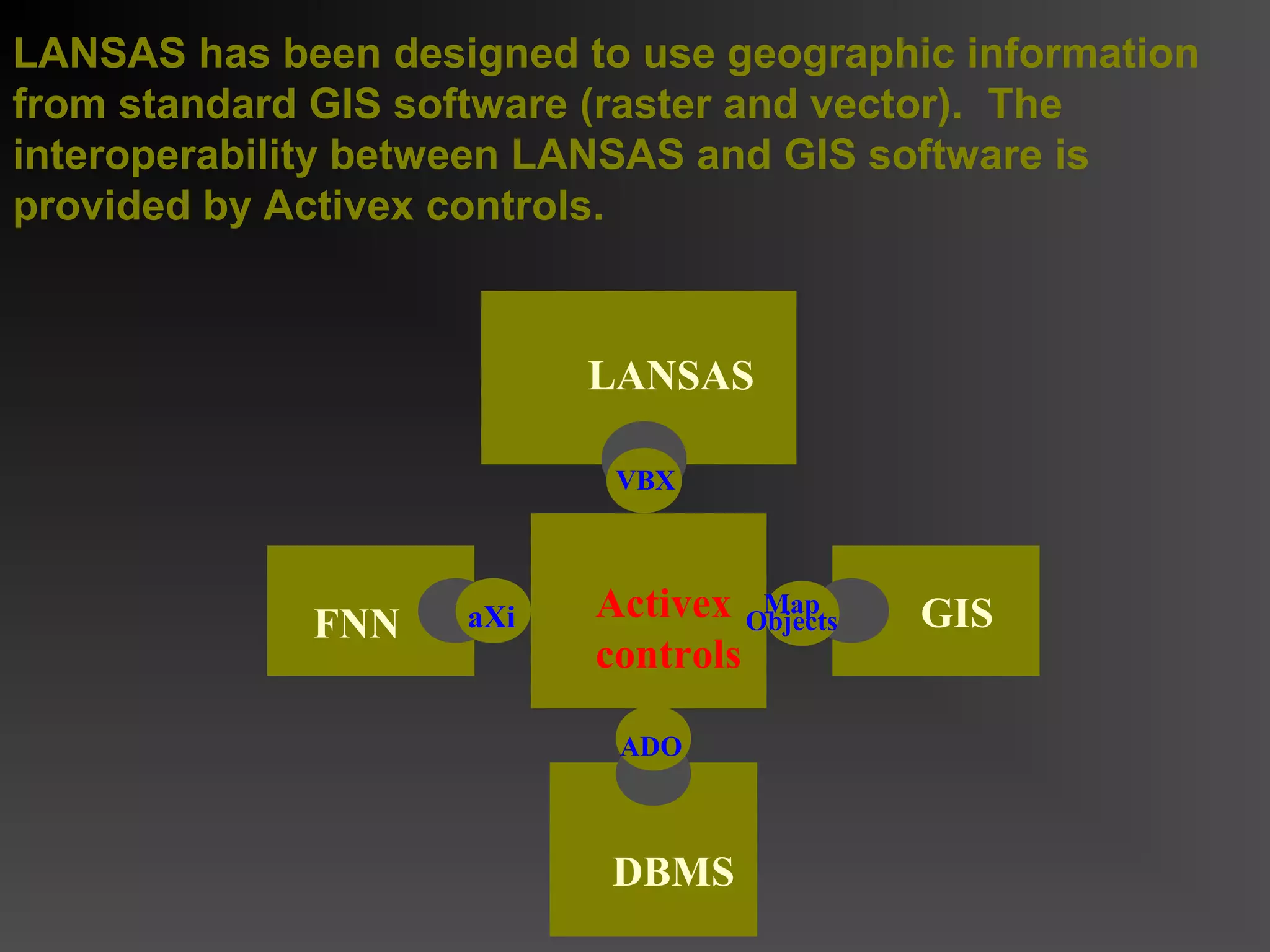
The research proposal outlines a new computer system for land suitability assessment that utilizes fuzzy set theory and artificial neural networks to address the limitations of existing methods in evaluating land compatibility for specific management practices. It aims to improve the accuracy and efficiency of land suitability assessment by integrating site-specific and universal knowledge, ultimately creating a system known as 'lansas' that can conduct comprehensive evaluations and provide users with accessible information on various crops. Current data collection and field research are ongoing to support the development of this system.