SlideShare a Scribd company logo
1 of 3
Download to read offline
Geological Engineer. Francisco Lucena.                    (Pictures Field Experiences – Samples. 1 of 3)


Petroleum Geology, Mud Logging, Well Engineer, Field Operations, Geological Operations, Geomechanical Parameters


                                      Pipeline Projects EPC (Water, Gas, Oil)


                      Earthworks - Land Moving, Excavation and Filled, Compaction, QA/QC
Geological Engineer. Francisco Lucena.                      (Pictures Field Experiences – Samples. 2 of 3)


Geotechnical Investigation Off Shore and Near Shore: SPT, Core Drilling HW-HQ-NW-NQ, CPT, Push Sampler, Soil and Rock.


  Off Shore – Near Shore. Party Chief, Operations and Logistics in Geotechnical, Geological and Geophysical Projects.


         Civil Works, Construction Inspection and Field Leader, Field Engineer, Concrete and Steel Buildings, EPC.
Geological Engineer. Francisco Lucena.                      (Pictures Field Experiences – Samples. 3 of 3)


Geotechnical Investigation, SPT, Core Drilling HW-HQ-NW-NQ, CPT, Push Sampler, Down Hole, Soil and Rock, Water Wells.


        Field Leader, Field Engineer, Operations and Logistics in Geotechnical, Geological and Geofisical Projects.


       Geological Exploration, Geohazards, Environments Studies. For Geotechnical, Oil & Gas and Mining Projects.

More Related Content

What's hot

Methods and stages of Mineral Exploration: Adaptive Resource Management Plan
Methods and stages of Mineral Exploration: Adaptive Resource Management PlanMethods and stages of Mineral Exploration: Adaptive Resource Management Plan
Methods and stages of Mineral Exploration: Adaptive Resource Management PlanNgatcha Bryan
 
ÖNCEL AKADEMİ: SOLID EARTH GEOPHYSICS
ÖNCEL AKADEMİ: SOLID EARTH GEOPHYSICSÖNCEL AKADEMİ: SOLID EARTH GEOPHYSICS
ÖNCEL AKADEMİ: SOLID EARTH GEOPHYSICSAli Osman Öncel
 
jennifer_digiulio_56x36in_poster
jennifer_digiulio_56x36in_posterjennifer_digiulio_56x36in_poster
jennifer_digiulio_56x36in_posterJennifer DiGiulio
 
Topographic attributes control groundwater flow and groundwater
Topographic attributes control groundwater flow and groundwaterTopographic attributes control groundwater flow and groundwater
Topographic attributes control groundwater flow and groundwaterAlexander Decker
 
High-Resolution 3D Seismic: Coal Mines Fields
High-Resolution 3D Seismic: Coal Mines FieldsHigh-Resolution 3D Seismic: Coal Mines Fields
High-Resolution 3D Seismic: Coal Mines FieldsAli Osman Öncel
 
A new metallogenic framework to aid mineral exploration in the Cobar Basin
A new metallogenic framework to aid mineral exploration in the Cobar BasinA new metallogenic framework to aid mineral exploration in the Cobar Basin
A new metallogenic framework to aid mineral exploration in the Cobar BasinNSW Environment and Planning
 
Geological Investigation of the Mono Basing using ArcGIS
Geological Investigation of the Mono Basing using ArcGISGeological Investigation of the Mono Basing using ArcGIS
Geological Investigation of the Mono Basing using ArcGISSachin Mehta
 

What's hot (10)

Methods and stages of Mineral Exploration: Adaptive Resource Management Plan
Methods and stages of Mineral Exploration: Adaptive Resource Management PlanMethods and stages of Mineral Exploration: Adaptive Resource Management Plan
Methods and stages of Mineral Exploration: Adaptive Resource Management Plan
 
Mercator Ocean newsletter 42
Mercator Ocean newsletter 42Mercator Ocean newsletter 42
Mercator Ocean newsletter 42
 
ÖNCEL AKADEMİ: SOLID EARTH GEOPHYSICS
ÖNCEL AKADEMİ: SOLID EARTH GEOPHYSICSÖNCEL AKADEMİ: SOLID EARTH GEOPHYSICS
ÖNCEL AKADEMİ: SOLID EARTH GEOPHYSICS
 
jennifer_digiulio_56x36in_poster
jennifer_digiulio_56x36in_posterjennifer_digiulio_56x36in_poster
jennifer_digiulio_56x36in_poster
 
Topographic attributes control groundwater flow and groundwater
Topographic attributes control groundwater flow and groundwaterTopographic attributes control groundwater flow and groundwater
Topographic attributes control groundwater flow and groundwater
 
High-Resolution 3D Seismic: Coal Mines Fields
High-Resolution 3D Seismic: Coal Mines FieldsHigh-Resolution 3D Seismic: Coal Mines Fields
High-Resolution 3D Seismic: Coal Mines Fields
 
Lecture 10p
Lecture 10pLecture 10p
Lecture 10p
 
A new metallogenic framework to aid mineral exploration in the Cobar Basin
A new metallogenic framework to aid mineral exploration in the Cobar BasinA new metallogenic framework to aid mineral exploration in the Cobar Basin
A new metallogenic framework to aid mineral exploration in the Cobar Basin
 
Report GFZ
Report GFZReport GFZ
Report GFZ
 
Geological Investigation of the Mono Basing using ArcGIS
Geological Investigation of the Mono Basing using ArcGISGeological Investigation of the Mono Basing using ArcGIS
Geological Investigation of the Mono Basing using ArcGIS
 

Similar to Cv pictures Geological Engineer_francisco lucena

Geophysical survey for the risk management
Geophysical survey for the risk managementGeophysical survey for the risk management
Geophysical survey for the risk managementMario Naldi
 
Geophysical survey for the risk management
Geophysical survey for the risk managementGeophysical survey for the risk management
Geophysical survey for the risk managementMario Naldi
 
Introduction about seismic methods.pptx
Introduction about seismic methods.pptxIntroduction about seismic methods.pptx
Introduction about seismic methods.pptxssuser6ceee1
 
Geotechnical studies_EG-Projects_17-01_2022.pptx
Geotechnical studies_EG-Projects_17-01_2022.pptxGeotechnical studies_EG-Projects_17-01_2022.pptx
Geotechnical studies_EG-Projects_17-01_2022.pptxKumarShubham771183
 
Dr. Ebere Benard CV_2017
Dr. Ebere Benard CV_2017Dr. Ebere Benard CV_2017
Dr. Ebere Benard CV_2017Ebere Benard
 
Terrestrial Laser Scanning (TLS) Method - Robert Kayen
Terrestrial Laser Scanning  (TLS) Method - Robert KayenTerrestrial Laser Scanning  (TLS) Method - Robert Kayen
Terrestrial Laser Scanning (TLS) Method - Robert KayenEERI
 
Jim_Mitchell_Nottingham Centre for Geomechanics_talk.ppt
Jim_Mitchell_Nottingham Centre for Geomechanics_talk.pptJim_Mitchell_Nottingham Centre for Geomechanics_talk.ppt
Jim_Mitchell_Nottingham Centre for Geomechanics_talk.pptFiratPulat
 
MINE -121 Mine Life Stages.pptx
MINE -121 Mine Life Stages.pptxMINE -121 Mine Life Stages.pptx
MINE -121 Mine Life Stages.pptxQusainRaza1
 
Integration of data for mineral explorataion
Integration of data for mineral explorataionIntegration of data for mineral explorataion
Integration of data for mineral explorataionkrishanunath1
 
4- Geophysics and exploration
4- Geophysics and exploration4- Geophysics and exploration
4- Geophysics and explorationElsayed Amer
 
Community Environmental Monitoring
Community Environmental MonitoringCommunity Environmental Monitoring
Community Environmental MonitoringIPCM2015
 
lect 4- petroleum exploration- part1.pdf
lect 4- petroleum exploration- part1.pdflect 4- petroleum exploration- part1.pdf
lect 4- petroleum exploration- part1.pdftahahaider8
 
Importance of geophysics in petroleum industry
Importance of geophysics in petroleum industryImportance of geophysics in petroleum industry
Importance of geophysics in petroleum industryFarida Ismayilova
 
Resumesmall
ResumesmallResumesmall
Resumesmallmtegley
 

Similar to Cv pictures Geological Engineer_francisco lucena (20)

T11 geophysical testing-landschoot
T11 geophysical testing-landschootT11 geophysical testing-landschoot
T11 geophysical testing-landschoot
 
Geophysical survey for the risk management
Geophysical survey for the risk managementGeophysical survey for the risk management
Geophysical survey for the risk management
 
Geophysical survey for the risk management
Geophysical survey for the risk managementGeophysical survey for the risk management
Geophysical survey for the risk management
 
Introduction about seismic methods.pptx
Introduction about seismic methods.pptxIntroduction about seismic methods.pptx
Introduction about seismic methods.pptx
 
Geotechnical studies_EG-Projects_17-01_2022.pptx
Geotechnical studies_EG-Projects_17-01_2022.pptxGeotechnical studies_EG-Projects_17-01_2022.pptx
Geotechnical studies_EG-Projects_17-01_2022.pptx
 
Introduction of engineering geology
Introduction of engineering geologyIntroduction of engineering geology
Introduction of engineering geology
 
Introduction of engineering geology
Introduction of engineering geologyIntroduction of engineering geology
Introduction of engineering geology
 
Dr. Ebere Benard CV_2017
Dr. Ebere Benard CV_2017Dr. Ebere Benard CV_2017
Dr. Ebere Benard CV_2017
 
CV mona-rev 2
CV mona-rev 2CV mona-rev 2
CV mona-rev 2
 
Resume2009
Resume2009Resume2009
Resume2009
 
Terrestrial Laser Scanning (TLS) Method - Robert Kayen
Terrestrial Laser Scanning  (TLS) Method - Robert KayenTerrestrial Laser Scanning  (TLS) Method - Robert Kayen
Terrestrial Laser Scanning (TLS) Method - Robert Kayen
 
Jim_Mitchell_Nottingham Centre for Geomechanics_talk.ppt
Jim_Mitchell_Nottingham Centre for Geomechanics_talk.pptJim_Mitchell_Nottingham Centre for Geomechanics_talk.ppt
Jim_Mitchell_Nottingham Centre for Geomechanics_talk.ppt
 
MINE -121 Mine Life Stages.pptx
MINE -121 Mine Life Stages.pptxMINE -121 Mine Life Stages.pptx
MINE -121 Mine Life Stages.pptx
 
Integration of data for mineral explorataion
Integration of data for mineral explorataionIntegration of data for mineral explorataion
Integration of data for mineral explorataion
 
4- Geophysics and exploration
4- Geophysics and exploration4- Geophysics and exploration
4- Geophysics and exploration
 
Community Environmental Monitoring
Community Environmental MonitoringCommunity Environmental Monitoring
Community Environmental Monitoring
 
lect 4- petroleum exploration- part1.pdf
lect 4- petroleum exploration- part1.pdflect 4- petroleum exploration- part1.pdf
lect 4- petroleum exploration- part1.pdf
 
Importance of geophysics in petroleum industry
Importance of geophysics in petroleum industryImportance of geophysics in petroleum industry
Importance of geophysics in petroleum industry
 
Resumesmall
ResumesmallResumesmall
Resumesmall
 
Scope of Geology for Civil Engineer
Scope of Geology for Civil EngineerScope of Geology for Civil Engineer
Scope of Geology for Civil Engineer
 

Cv pictures Geological Engineer_francisco lucena

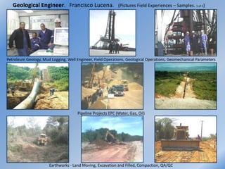
  • 1. Geological Engineer. Francisco Lucena. (Pictures Field Experiences – Samples. 1 of 3) Petroleum Geology, Mud Logging, Well Engineer, Field Operations, Geological Operations, Geomechanical Parameters Pipeline Projects EPC (Water, Gas, Oil) Earthworks - Land Moving, Excavation and Filled, Compaction, QA/QC
  • 2. Geological Engineer. Francisco Lucena. (Pictures Field Experiences – Samples. 2 of 3) Geotechnical Investigation Off Shore and Near Shore: SPT, Core Drilling HW-HQ-NW-NQ, CPT, Push Sampler, Soil and Rock. Off Shore – Near Shore. Party Chief, Operations and Logistics in Geotechnical, Geological and Geophysical Projects. Civil Works, Construction Inspection and Field Leader, Field Engineer, Concrete and Steel Buildings, EPC.
  • 3. Geological Engineer. Francisco Lucena. (Pictures Field Experiences – Samples. 3 of 3) Geotechnical Investigation, SPT, Core Drilling HW-HQ-NW-NQ, CPT, Push Sampler, Down Hole, Soil and Rock, Water Wells. Field Leader, Field Engineer, Operations and Logistics in Geotechnical, Geological and Geofisical Projects. Geological Exploration, Geohazards, Environments Studies. For Geotechnical, Oil & Gas and Mining Projects.