Appendix D Hazard Analysis ProcessInstructor GuideAppendix .docx
Assessing Emergency Management Integration in Tribally Inclusive Areas to Reduce Disaster Impacts
1. ABSTRACT
Designed and implemented by a student team from the CREATE sponsored Working Together for A Safer Tomorrow (WTST) program,
this project applies a three step model to determine the ability of multi-jurisdictional, demographically diverse areas, especially tribally
inclusive geographic areas (TIGA), to integrate resources and services with the goal of operating cooperatively as self-sustaining
communities in the event of natural disasters or terror attacks.
Methods: Step 1: A risk matrix is used to determine a risk ranking of regional disaster and terror events.
Step 2: An area in the study region is chosen and a real time tri-level status report is conducted by area stakeholders.
An integrated operability score, or IOS, is calculated to determine cooperative capabilities.
Step 3:As the model is incorporated across jurisdictions and agencies, a Cumulative Regional Integrated Operability
Score, or CRIOS, is derived. Once the CRIOS tool is applied, strategies incorporating integration and shared utilizationof
regionally available human and material resources can be coordinated enhancing preparedness and mitigation
capabilities for both tribal and non-tribal communities!
Results: Beginning in October 2008, this project became directly aligned with the January 2009 Homeland Security’s mission relevant
directive requiring local, state, and tribal integration. A pilot model was field tested in the Pacific Northwest and results submitted to the
WTST mentor. To date,15 case studies ,including NY Iroquois, are included with the Shinnecock TIGA, Long Island, since Spring, 2012.
Discussion: This project is related to the Social and Behavioral Sciences research area via the introduction and application of a user
friendly model and tools designed to promote diverse entities and jurisdictions to work together to identify critical indicators and strategies
to operate as self-sustaining communities within tribal regions in catastrophic events.
Broader Impacts of this study include:
a.) The creation of a risk ranked database that can be used for the establishment of resource allocation priorities based upon the CRIOS. A
user friendly multi-variable decision making program is being designed to provide a strategic database for TIGA EM stakeholders to apply
CRIOS (S. Garland, Old Dominion University and NAVSEA)
b.) The development of qualitatively derived statistical indicators related to TIGA EM perceived abilities to function across jurisdictions as
self-sustaining communities in the event of disasters. In collaboration, the Organization Cooperation Model by Coles and Zhuang is being
applied to TIGA EM (“Decisions in Disaster Recovery: A Game Theoretic Perspective of Organization Cooperation” JHSEM, vol.8, 2011).
Based on a survey of perceived abilities, a pilot model is being designed in collaboration with the Mohawk Council of Akwesasne's
Emergency Measures Program and the Hogansburg Akwesasne Volunteer Fire Department (HAVFD).
c.) Improved cooperation of resources and capabilities reduces economic impact of disaster events and aligns with CREATE’s mission.
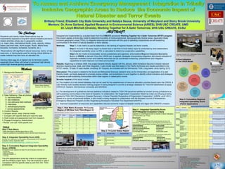
To Assess and Achieve Emergency Management Integration in Tribally
Inclusive Geographic Areas to Reduce the Economic Impact of
Natural Disaster and Terror Events
Brittany Friend, Elizabeth City State University and Natalya Sousa, University of Maryland and Stony Brook University
Mentors: Dr. Anne Garland, Applied Research in Environmental Science (ARIES), DHS USC CREATE, UMD
Dr. Lloyd Mitchell (Oneida), Working Together for A Safer Tomorrow, DHS USC CREATE, ECSU
Methods
1. Background Research
2. Data Gathering: (See all photos)
A. real time events
B. site visitations
C. non-obtrusive field methods
D. interviews
E. workshops/symposia
F. survey assessments
3. Confirm Results:
• Compare social, news, internet media
• Compare with specific field and real time data
4. Draft model and assessment tool from research
5. Engage Emergency Stakeholders:
• Revise and use TIGA specific tool
TOOLS
Step I: Risk Matrix
• Utilize Risk Matrix to Identify Higher Risks in TIGA
• Organize qualitative and quantitative data to identify hazard frequencies
Step 2: Integrated Operability Score (IOS)
Modified from Statewide Communication Interoperability (SCIP) Weighted
Evaluation Criteria, September 2007,
(http://www.dhs.gov/files/programs/gc_1225902750156.shtm)
Step 3: Cumulative Regional Integrated Operability
Score (CRIOS)
Introduced to local, regional and tribal Fire and Emergency Services at:
• workshops,
• distance learning,
• self-guide website, or
• meetings.
The EM stakeholders scale the criteria in cooperation
with the ARIES project team. The risk analysis is valid if
completed with the specific data by and from the TIGA
jurisdictions.
Selected References
Texts: *Benedict, Jeff (2000) Without Reservation USA, Harper Collins: New York, New York, USA. ISBN 0060193670
*Cowger, Thomas W. (1999) The national Congress of American Indians: The Founding Years. University of Nebraska Press: Lincoln Nebraska, USA 0-8032-1502-9
*Jospehy, A, Jr., Nagel, J., and Johnson, T. Eds (1999) Red Power, The American Indians’ Fight for Freedom, 2nd Ed. University of Nebraska Press: Lincoln Nebraska, USA. ISBN 0-8032-2587-2 *Gaddis, John Lewis (2004). Surprise, Security, and the American Experience. Harvard University Press: Cambridge, Massachusetts, USA ISBN 0674-011740
*Gardner, L., Kalt, J., and Spilde, K. (2005) Annontated Bibliography: the Social and Economic Impacts of Indian and Other Gaming. The Harvard Project of American Indian Economic Development. John F. Kennedy School of Government, Harvard University. Harvard University Press: Cambridge, Massachusetts, USA ISBN 0-974394-69-6
*Michel, L. and Herbeck, D. (2001) American Terrorist: Timothy McVeigh and the Oklahoma City Bombing. Harper Collins Publishers: New York, New York, USA ISBN 0-06-039407-2
*Miller, J., Engelberg, S., Broad, W. (2001)Germs: Biological Weapons and America’s Secret War. Simon and Schuster: New York, New York, USA ISBN 0-684-87158-0
*Raiffa, Howard (1970) Decision Analysis: Introductory Lectures on Choices Under Uncertainty.Addison-Wesley Publishing: Reading Massachusetts, USA ISBN 0-201-06290-9
*Richardson, H., Gordon, P., Moore II, J.( 2005) The Economic Impacts of Terrorist Attacks Edward Algar Publishing: Northhampton, Massachusetts, USA ISBN 1-84542-301-1
*Taylor, J., and Kalt, J. (2005) American Indians on Reservations: A Databook of Socioeconomic Change Between 1ht 1990 and 2000 Census. The Harvard Project of American Indian Economic Development. John F. Kennedy School of Government, Harvard University. Harvard University Press: Cambridge, Massachusetts, USA ISBN 0-9764426-0-4
*Weibel-Orlando, Joan (1999) Indian Country L.A., Maintaining Ethnic Community in Complex Society. University of Illinois Press: Urbana, Illinois, USA ISBN 0-252-06800-9
Web Based Sources: *National Indian Gaming Commission (2006) Library and Resource Center http://www.indiangaming.org/library/resource-center/index.html or
http://www.indiangaming.org/library/faqs/index.shtml. Accessed Various Times 2008-2009
*Oyasin. (1996). Fema. (2004). List of 561 Indian reservations, Tribal Communities, Alaska Native Corporations and other Federally Recognized Indigenous Groups. U.S. Bureau of Indian Affairs, Accessed July, 2006 http://www.doi.gov/bureau-indian-affairs.html
Other Documents: *Department of Homeland Security (2006) Nationwide Plan Review: Phase 2 Report, U.S. Government Printing Office
*Miller, John (2006) Legislature’s move could force Idaho to address murals of Indian lynching. The Sante Fe Free New Mexican/eNewMexican 11 April 2006. Accessed 11 July, 2006
*Spitzer, M. L. (2004). Domestic Antiterrorism Planning. NTI – National Journal Group, http://www.nti.org Accessed July 2006
The Challenge
Residents and nearby Indian Reservations may be
inadvertently exposed to long term natural disasters and terror
related activities simply due to geographic location
(i.e. major cities, international border, ports, airports, military
bases, sea level rises, storm surges, floods, debris flows,
blizzards, hurricanes, tornadoes, tsunamis, etc.).
Reservations with significant natural resources, dams, oil rigs,
reservoirs, or having lands used for storing critical defense or
waste material may also have an elevated risk.
Gaming tribes may be at highest risk for terrorism events,
especially those tribes with actual or perceived high density
and/or high revenue gaming operations.
Step 1: Risk Matrix Example: Tri-County
Region of SW New York TIGA (Region V)
Risk Occurrence Scale= 1 (monthly), 2 (quarterly), 3 (bi-annually), 4 (annually), 5 (2-5 yrs), 6 (5-10 yrs)
DISASTER
EVENTS
Tribal Cities and
Towns
County Region State
Flooding 6 6 6 6 0
Blizzards 2 2 2 2 2
Debris Flows 1 1 1 0 0
Nuclear Waste 1 1 1 1
Roadway
Vandalism
5 5 0 0 0
Business
Closures
(smoke shops)
0 0 0 0 0
Bio-Terrorism 0 0 0 0 0
Step 2 : Integrated Operability Score
SCIP=Weighted Evaluation Criteria
(applied to Local/Regional EM to Identify Critical Indicators
of Cooperation per TIGA)
Example:
(1) 20% Governance
4.4 Identify the members of the governing body and any of its
committees. (List them according to the categories recommended for a
communications interoperability committee in the All-Inclusive Approach.)
Critical Indicators Units to Scale
Organizational Structure Public/Private/Tribal/Combined
Staff Structure/Qualifications Hours/month
Emotional Support Frequency
Eco-Heritage Recognition Involvement Levels
4.6. Describe multi-jurisdictional, multi-disciplinary agreements
needed for decision-making and for sharing resources.
Critical Indicators Units to Scale
Mutual Aid Procedures and Practice
Emergency Management Resources Sharing Levels
LEVEL DEFINITION DESCRIPTION
High What we are doing
best
Medium What we are trying
to do
Low What we cannot do
well
Step 2: Tri-Level Status Report
Modified with Permission from Elaine Willman, Public
Administrator, Hobart, WI, Citizens Equal Rights Alliance
STRUCTURE:
Mutual Aid
Infrastructure
Organization
Staff
MAPPING:
Local, Tribal,
Regional,
Field, Interactive,
Friendly, Internet
Independent
FACILITIES:
Containment
Shelters
Medical
RESOURCES:
Equipment
Funding
SUPPORT:
Emotional
Eco-Heritage
TRAINING:
Outreach
Collaborative
Frequency
Scenarios
RESILIENCE:
Managed Risks in
Tribally Inclusive
Geographic Areas
CREDIT: Akwesasne St. Regis Mohawk
Fire and Emergency Measures
by Regina Jacobs, EMO
Barrow, Alaska Meetings,
Symposia, and Open House
Cattaraugus Indian Reservation
Field Visit in Real time
Gowanda Volunteer Fire, Cattaraugus County, and NY
Indian Reservation EM Workshop
Gowanda Volunteer
Fire, Cattaraugus
County, and NY Indian
Reservation EM
Workshop
Hogansburg Akwesasne Volunteer Fire
Department (HAVFD) Interview
Eastern Band of Cherokee Indian
Fire Department Interviews
Joint Center for Disaster Research, Massey, University,
NZ, Summer Institute, and Wellington Faults Field Visit .
Maori Preparedness for Civil Defense
Acknowledgements
This project was funded through the Center for Risk and
Economic Analysis of Terrorism Events (CREATE) Center of
Excellence by a grant from the Department of Homeland
Security, Science and Technology Directorate, Office of
University Programs. Contact: ariesnonprofit@yahoo.com
1. Dr. Lloyd Mitchell, CREATE, Working Together for a Safer Tomorrow
2. Dr. Anne Garland, ARIES, Applied Research In Environmental Science
3. Dr. Isaac Maya , CREATE, Research Director
4. John Coles and Dr. Jun Zhuang , University of Buffalo
5. Spencer Garland, Old Dominion University
6. Regina Jacobs, Mohawk Emergency Measures
7. ARIES, www.ariesnonprofit.com
CRITERIA SUB-CRITERIA SCALE SCORE COMMENTS
0 1 2 3 4 5
Nothing Insufficient Unsatisfactory Sufficient Satisfactory Resilient
Mutual Aid
Community / Volunteer 3
2
Need to meet a certain threshold before the state or feds
assist. This is insufficient as First Nations are usually federal
recognized and shouldn't have to wait for mutual aid. Once a
declaration has been made, mutual assistance should arrive.
In theory, we have no border in emergency situtions.
However, it can become a political issue with local councils.
Local Government 2
County / Municipal 3
State / Provincial 1
Federal 1
Mapping
Technology Field 4
4
Both the US & Canadian Tribal Governments own and operate
their own IT Programs (Computers services, programming,
training, mapping, etc.
Friendly 4
Independent 4
Interactive 4
Internet 4
Volunteer
Training Collaborative 1
2.2
Requested training - when volunteers requests specific
training, it should always be delivered. If they can't depend on
you, you can not depend on them It's mutual respect If they
want it or need it, give it to them.
Exercises 1
Frequency 3
Jurisdiction Levels 3
Requested 3
EM
Resources
Community / Volunteer 2
1.8
Akwesasne residents donate and support our emergency
responders. MOU's are an asset. Funding is very limited on
Canadian portion. Council Personnel Policies allow for our
volunteers to leave their place of work for emergency
response.
Local Government 2
County / Municipal 3
State / Provincial 1
Federal 1
Emotional
Support Community / Volunteer 1
1
Emotional support is available on so many levels. However,
our Community is not big on using professional services due to
confidentiality issues. Confidentiality vs. Work Ethics
Local Government 1
County / Municipal 1
State / Provincial 1
Federal 1
Heritage
RecognitionCommunity / Volunteer 3
1.8
State, provincial and federal agencies recognize it, but often
do not respect it. CBSA is a great example. Training is
provided by MCA in this area.
Local Government 3
County / Municipal 1
State / Provincial 1
Federal 1
Step 3: Cumulative Regional
Integrated Operability Score
(Partial Application)
Critical Indicators
of the CRIOS Model