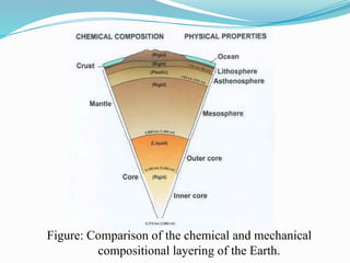
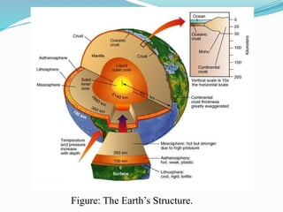
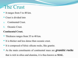
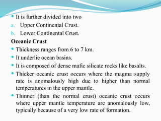
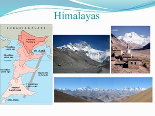
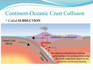
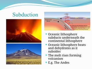
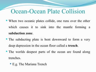
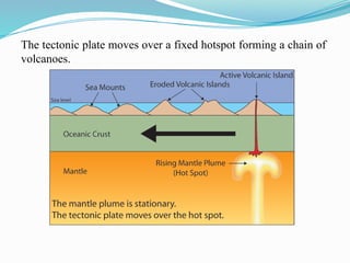
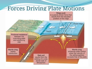
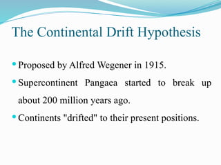
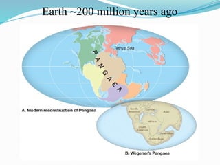
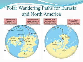
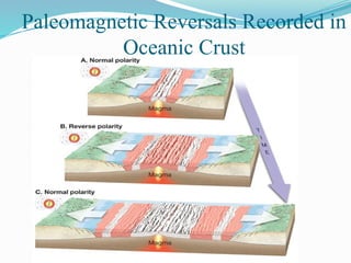
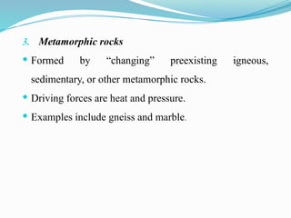
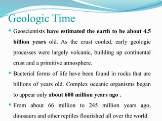
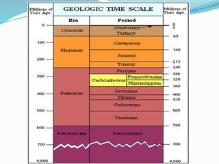
Physical Geology
THE SCIENCE OF GEOLOGY
Geology, from the Greek geo and logos, is defined as the
study of Earth, it also includes the study of the planets
and moons in our solar system.
OR
Geology is the study of the Earth, including the
materials that it is made of, the physical and chemical
changes that occur on its surface and in its interior, and
the history of the planet and its life forms.
Who Needs Geology?
 Supplying Things We Need
 Protecting the Environment
 Avoiding Geologic Hazards
 Understanding Our Surroundings
Geology
Geology is generally divided into two broad areas
 Physical Geology
Physical geology is the study of the earth's rocks, minerals, and
soils, as well as the processes operating within Earth and on its
surface.
 Historical Geology
Historical Geology examines the origin and evolution of Earth, its
continents, oceans, atmosphere, and life.
Physical Geology
Physical geology is concerned with the materials that make
up the Earth as well as the processes that operate on those
materials, either at or beneath the surface of the Earth.
What materials?: elements, minerals, rocks, water.
What processes?: plate tectonics, volcanic eruptions,
earthquakes, mountain building, the
action of rivers, glaciers, oceans, and
wind, and weathering and erosion.
The Earth's Origin
 According to the widely accepted nebular hypothesis, the
planets and moons in the solar system, including Earth,
formed from a huge cloud called the solar nebula of
mostly hydrogen and helium.
 Nebula began to contract about 5 billion years ago.
Contraction, rotation, and dropping temperatures resulted in
the formation of small particles, the first being nickel and iron.
 Formation of Earth’s layered structure. Metals sank to the
center. Molten rock rose to produce a primitive crust.
 Although the earth has been cooling ever since and has
formed a hard outer crust, part of the interior is still hot
and molten.
 Chemical segregation established the three basic divisions
of Earth’s interior.
 A primitive atmosphere evolved from gases in Earth’s
interior .
Internal Processes: How the Earth’s
Internal Heat Engine Works
 As the earth cools, the intense heat being produced in the core
creates convection currents in the mantle that bring hot mantle
material up toward the crust, and colder mantle and crustal rocks
sink downward.
 The effect of this internal heat engine on the crust is of great
importance in geology. The forces generated inside the Earth, called
tectonic forces, cause deformation of rock as well as vertical and
horizontal movement of portions of Earth' crust (plates).
Figure: Convection currents in the mantle.
Structure of Earth
 The interior of Earth is layered structure.
 Layers are define by the either chemical or mechanical
properties.
Mechanically Earth is divided into
1. Lithosphere.
2. Asthenosphere.
3. Mesosphere.
4. Outer Core.
5. Inner Core.
Chemically Earth is divided into
1. Crust.
2. Upper mantle.
3. Lower mantle.
4. Outer Core.
5. Inner Core.
Figure: Comparison of the chemical and mechanical
compositional layering of the Earth.
Figure: The Earth’s Structure.
The Crust
 It ranges from 5 to 40 km.
 Crust is divided into
a. Continental Crust.
b. Oceanic Crust.
Continental Crust.
 Thickness ranges from 35 to 40 km.
 It is thicker and less dense than oceanic crust.
 It is composed of felsic silicate rocks, like granite.
 As the main constituents of continental mass are granitic rocks
that is rich in silica and alumina, it is thus known as SIAL.
 It is further divided into two
a. Upper Continental Crust.
b. Lower Continental Crust.
Oceanic Crust
 Thickness ranges from 6 to 7 km.
 It underlie ocean basins.
 It is composed of dense mafic silicate rocks like basalts.
 Thicker oceanic crust occurs where the magma supply
rate is anomalously high due to higher than normal
temperatures in the upper mantle.
 Thinner (than the normal crust) oceanic crust occurs
where upper mantle temperature are anomalously low,
typically because of a very low rate of formation.
 It is further divided into
a. Oceanic Layer 1.
b. Oceanic Layer 2.
c. Oceanic Layer 3.
The oceanic crust has the average composition of
Basaltic rock that is rich in silica and magnesium, it is
therefore called SIMA.
Characteristics Oceanic Crust Continental Crust
Average
thickness
7 km 20 to 70 km (thickest
under mountains)
Seismic P-wave
velocity
7 km/second 6 km/second (higher in lower
crust)
Density 3.0 gm/cm3 2.7 gm/cm3
Probable Basalt underlain Granite, other
composition by gabbro plutonic rocks, schist, gneiss
(with sedimentary
rock cover)
Characteristics of Oceanic Crust and Continental Crust
Moho
 It is crust- mantle boundary and also know as mantle
transition zone.
 This zone is between 410 and 660 km depth.
 There are two physically different event at this zone:
1. Seismic velocity.
2. Chemical discontinuity.
The Mantle
 The mantle lies directly below the crust.
 It is almost 2900 kilometers thick and makes up 82 percent of
the Earth’s volume.
 Although the chemical composition may be similar
throughout the mantle, Earth temperature and pressure
increase with depth.
 These changes cause the strength of mantle rock to vary with
depth, and thus they create layering within the mantle.
 The upper part of the mantle consists of two layers.
1. The solid lithosphere is composed of the crust and
the upper part of the mantle.
2. The softer, more flexible part of the mantle
underneath the lithosphere is the asthenosphere.
The Lithosphere
 The outer part of the Earth, including both the uppermost mantle
and the crust, makeup the lithosphere (Greek for “rock layer”).
 The uppermost mantle is relatively cool and consequently is hard,
strong rock.
 In fact, its mechanical behavior is similar to that of the crust.
 The lithosphere can be as thin as 10 kilometers where tectonic
plates separate. However, in most regions, the lithosphere varies
from about 75 kilometers thick beneath ocean basins to about 125
kilometers under the continents.
 A tectonic (or lithospheric) plate is a segment of the lithosphere.
The Asthenosphere
 At a depth varying from about 75 to 125 kilometers, the
strong, hard rock of the lithosphere gives way to the weak,
plastic asthenosphere.
 This change in rock properties occurs over a vertical distance
of only a few kilometers, and results from increasing
temperature with depth.
 Although the temperature increases gradually, it crosses a
threshold at which the rock is close to its melting point.
 As a result, 1 to 2 percent of the asthenosphere is liquid,
and the asthenosphere is mechanically weak and plastic.
Because it is plastic, the asthenosphere flows slowly,
perhaps at a rate of a few centimeters per year.
Figure: The structure of the Earth, showing the lithosphere
and asthenosphere (not to scale).
Gutenberg Discontinuity
 It is core- mantle boundary.
 It generates strong seismic reflections and thus
represents a composition interface.
The Core
 The core is the innermost of the Earth’s layers.
 It is a sphere with a radius of about 3470 kilometers and is
composed largely of iron and nickel.
 The outer core is molten because of the high temperature in
that region.
 Near its center, the core’s temperature is about 6000ºC, as
hot as the Sun’s surface.
 The pressure is greater than 1 million times that of the
Earth’s atmosphere at sea level.
 The extreme pressure overwhelms the temperature effect
and compresses the inner core to a solid.
 Core is subdivided into
a. Outer Core.
b. Inner Core.
Outer Core
 It is at the depth of 2891 to 5150 km.
 It does not transmit S-waves.
 It is fluid and contains iron, nickel and small quantity of
lighter elements.
Inner Core
 It is at the depth of 5150 km.
 The boundary between outer and inner core is sharp and is not
represented by any transition zone.
 Inner core is pure iron.
Geology and the Formulation of
Theories
 Theory
A theory is a explanation for one or several related natural phenomena
supported by a large body of objective evidence.
Hypothesis
A hypothesis is a provisional explanation for observations that is subject to
repeated testing.
Scientific Method
Theories are formulated through the process known as the scientific
method. It involves gathering of data, formulating and testing of
hypotheses and proposing theories.
Plate Tectonic Theory
What is plate tectonic theory?
 The lithosphere is divided into rigid plates that move over
the asthenosphere formed the foundation of plate tectonic
theory.
 It has provided a framework for knowing the composition,
structure, and internal processes of Earth on a global scale.
Why is plate tectonic theory important in geology?
 Plate tectonic theory provides the basis for relating many
seemingly unrelated phenomena.
 Plate movement results in volcanic activity, earthquake,
and mountain building. It also affects the formation and
distribution and evolution of Earth’s biota.
Figure: Map of the major tectonic plates on Earth.
 Divergent
 Convergent
 Transform
Three types of plate boundary
 Spreading ridges
 As plates move apart new material is erupted to fill the gap
Divergent Boundaries
Age of Oceanic Crust
 Iceland has a divergent
plate boundary running
through its middle
Iceland: An example of continental rifting
 There are three styles of convergent plate boundaries
a. Continent-continent collision.
b. Continent-oceanic crust collision.
c. Ocean-ocean collision.
Convergent Boundaries
 Forms mountains, e.g. Himalayas
Continent-Continent Collision
Himalayas
 Called SUBDUCTION
Continent-Oceanic Crust Collision
 Oceanic lithosphere
subducts underneath the
continental lithosphere
 Oceanic lithosphere heats
and dehydrates as it
subsides
 The melt rises forming
volcanism
 E.g. The Andes
Subduction
 When two oceanic plates collide, one runs over the other
which causes it to sink into the mantle forming a
subduction zone.
 The subducting plate is bent downward to form a very
deep depression in the ocean floor called a trench.
 The worlds deepest parts of the ocean are found along
trenches.
 E.g. The Mariana Trench
Ocean-Ocean Plate Collision
 Where plates slide past each other
Transform Boundaries
Above: View of the San
Andreas transform
fault
-Subduction - Rifting - Hotspots
Volcanoes are formed by:
 Hot mantle plumes breaching the surface in
the middle of a tectonic plate
What are Hotspot
Volcanoes?
Photo: Tom Pfeiffer /
www.volcanodiscovery.com
The Hawaiian island chain are
examples of hotspot volcanoes.
The tectonic plate moves over a fixed hotspot forming a chain of
volcanoes.
Forces Driving Plate Motions
The Continental Drift Hypothesis
 Proposed by Alfred Wegener in 1915.
 Supercontinent Pangaea started to break up
about 200 million years ago.
 Continents "drifted" to their present positions.
Earth ~200 million years ago
Objections to the Continental Drift
Hypothesis:
 Lack of a mechanism for moving continents.
 Wegener incorrectly suggested that continents
broke through the ocean crust.
Continental Drift: Evidence
Evidence used in support of continental drift
hypothesis:
 Fit of the continents.
 Fossil evidence.
 Rock type and structural similarities.
 Paleoclimatic evidence.
Continental Drift Evidence: Fit of Continents
Continental Drift: Fossil Evidence
Rock type and Structural Similarities.
Ancient Glacial Features
Continental Drift and Paleomagnetism
 A renewed interest in continental drift initially
came from rock magnetism.
 Magnetized minerals in rocks:
a. Show the direction to Earth’s magnetic poles
b. Provide a means of determining their latitude
of origin.
Continental Drift and Paleomagnetism
Polar wandering
 The apparent movement of the magnetic poles indicates that
the continents have moved.
 It also indicates Europe was much closer to the equator
when coal-producing swamps existed.
 Curves for North America and Europe have similar paths but
are separated by about 24 degrees of longitude.
 Differences between the paths can be resigned if the
continents are placed next to one another.
Polar Wandering Paths for Eurasia
and North America
A Scientific Revolution Begins
 The seafloor spreading hypothesis was proposed by
Harry Hess in the early 1960s.
Paleomagnetic Reversals Recorded in
Oceanic Crust
The Rock Cycle
 James Hutton had the `big idea' that great cycles of rock
formation and deformation had affected the Earth in the
past.
 Hutton had discovered scientific evidence for nearly all
the processes that we now call the rock cycle.
 He had linked them together into a cycle, and he had
realized that there must have been a lot of time available
for the processes to produce rocks.
We can summarize his discoveries as:
 Weathering - how this attacked `rocks at the Earth's surface',
making `rotten rocks and soil';
 Erosion/transportation - how soil was eroded into `mobile
sediments';
 Deposition - how sediment was deposited and realized that
there must be lots of deposition in the sea, producing
`sedimentary sequences';
 Compaction/cementation - sediment must naturally become
consolidated at the bottom of the sea to form `sedimentary
rocks';
 Metamorphism - he understood that limestone was
changed into marble by heat in metamorphism, so marble
is a `metamorphic rock';
 Melting - he had found evidence which showed that
igneous rocks had once been hot enough to become
molten `magma';
 Crystallization - he had found examples of where
magma has crystallized into `igneous rocks';
Figure: The rock cycle.
1. Igneous rocks
 Cooling and solidification of magma (molten rock).
 Examples include granite and basalt.
2. Sedimentary rocks
 Accumulate in layers at Earth’s surface.
 Sediments are derived from weathering of preexisting.
 Examples include sandstone and limestone.
Basic Rock Types
3. Metamorphic rocks
 Formed by “changing” preexisting igneous,
sedimentary, or other metamorphic rocks.
 Driving forces are heat and pressure.
 Examples include gneiss and marble.
Geologic Time
 Geoscientists have estimated the earth to be about 4.5
billion years old. As the crust cooled, early geologic
processes were largely volcanic, building up continental
crust and a primitive atmosphere.
 Bacterial forms of life have been found in rocks that are
billions of years old. Complex oceanic organisms began
to appear only about 600 million years ago .
 From about 66 million to 245 million years ago,
dinosaurs and other reptiles flourished all over the world.
 In contrast, human beings have existed in only about the
last 3 million years, less than a thousandth of the age of
Earth.
 Geologists measure geologic time in two different ways:
a. Relative age.
b. Absolute age.
Historical Notes
 About 2300 years ago, the Greeks, led by the philosopher
Aristotle, were among the first to try to understand the
earth. During the 1600s and 1700s, scientists believed the
earth had been produced by gigantic, sudden, catastrophic
events that built mountains, canyons, and oceans.
Uniformitarianism
 In the late 1700s, James Hutton, a Scottish doctor,
proposed that the physical processes that shape the world
today also operated in the geologic past a principle known
a uniformitarianism.
 Thus, scientists can explain events that occurred in the
past by observing changes occurring today. Sometimes
this idea is summarized in the statement “The present is
the key to the past.”
Catastrophism
 William, another early geologist, agreed that the Earth is
very old, but he argued that geologic change was
sometimes rapid.
 He was unable to give examples of such catastrophes. He
argued that they happen so infrequently that none had
occurred within human history.
Principle of Original Horizontality
 The principle of original horizontality is based on
observation that sediment usually accumulates in
horizontal layers.
Figure (a)sedimentary rocks deposited with horizontal bedding.
(b) tilted rocks.
Law of Superposition
 Another early concept was the law of superposition—in
an undeformed sequence of sedimentary rocks, each layer
is younger than the ones below it and older than those
above it.
Figure: In a sequence of sedimentary beds, the oldest
bed is the lowest, and the youngest is on top. These
beds become older in the order A,B ,C ,D ,E.
Principle of Crosscutting
 The principle of crosscutting relationships is based on
the obvious fact that a rock must first exist before
anything can happen to it.
Figure: Light granitic dikes cutting across older country
rock along the coast in southeast Alaska.
Law of Faunal Succession
 The law of faunal succession states that fossils in these
rocks occur in the same kind of order, and changes in
fossil content represent changes in time.
 Thus, rocks from different parts of the world containing
the same type of fossil formed about the same time.

chapter 1 Introduction to Physial geology

  • 1.
  • 2.
    THE SCIENCE OFGEOLOGY Geology, from the Greek geo and logos, is defined as the study of Earth, it also includes the study of the planets and moons in our solar system. OR Geology is the study of the Earth, including the materials that it is made of, the physical and chemical changes that occur on its surface and in its interior, and the history of the planet and its life forms.
  • 3.
    Who Needs Geology? Supplying Things We Need  Protecting the Environment  Avoiding Geologic Hazards  Understanding Our Surroundings
  • 4.
    Geology Geology is generallydivided into two broad areas  Physical Geology Physical geology is the study of the earth's rocks, minerals, and soils, as well as the processes operating within Earth and on its surface.  Historical Geology Historical Geology examines the origin and evolution of Earth, its continents, oceans, atmosphere, and life.
  • 5.
    Physical Geology Physical geologyis concerned with the materials that make up the Earth as well as the processes that operate on those materials, either at or beneath the surface of the Earth. What materials?: elements, minerals, rocks, water. What processes?: plate tectonics, volcanic eruptions, earthquakes, mountain building, the action of rivers, glaciers, oceans, and wind, and weathering and erosion.
  • 6.
    The Earth's Origin According to the widely accepted nebular hypothesis, the planets and moons in the solar system, including Earth, formed from a huge cloud called the solar nebula of mostly hydrogen and helium.  Nebula began to contract about 5 billion years ago. Contraction, rotation, and dropping temperatures resulted in the formation of small particles, the first being nickel and iron.
  • 7.
     Formation ofEarth’s layered structure. Metals sank to the center. Molten rock rose to produce a primitive crust.  Although the earth has been cooling ever since and has formed a hard outer crust, part of the interior is still hot and molten.  Chemical segregation established the three basic divisions of Earth’s interior.  A primitive atmosphere evolved from gases in Earth’s interior .
  • 9.
    Internal Processes: Howthe Earth’s Internal Heat Engine Works  As the earth cools, the intense heat being produced in the core creates convection currents in the mantle that bring hot mantle material up toward the crust, and colder mantle and crustal rocks sink downward.  The effect of this internal heat engine on the crust is of great importance in geology. The forces generated inside the Earth, called tectonic forces, cause deformation of rock as well as vertical and horizontal movement of portions of Earth' crust (plates).
  • 10.
  • 11.
    Structure of Earth The interior of Earth is layered structure.  Layers are define by the either chemical or mechanical properties. Mechanically Earth is divided into 1. Lithosphere. 2. Asthenosphere. 3. Mesosphere. 4. Outer Core. 5. Inner Core.
  • 12.
    Chemically Earth isdivided into 1. Crust. 2. Upper mantle. 3. Lower mantle. 4. Outer Core. 5. Inner Core.
  • 13.
    Figure: Comparison ofthe chemical and mechanical compositional layering of the Earth.
  • 14.
  • 15.
    The Crust  Itranges from 5 to 40 km.  Crust is divided into a. Continental Crust. b. Oceanic Crust. Continental Crust.  Thickness ranges from 35 to 40 km.  It is thicker and less dense than oceanic crust.  It is composed of felsic silicate rocks, like granite.  As the main constituents of continental mass are granitic rocks that is rich in silica and alumina, it is thus known as SIAL.
  • 16.
     It isfurther divided into two a. Upper Continental Crust. b. Lower Continental Crust. Oceanic Crust  Thickness ranges from 6 to 7 km.  It underlie ocean basins.  It is composed of dense mafic silicate rocks like basalts.  Thicker oceanic crust occurs where the magma supply rate is anomalously high due to higher than normal temperatures in the upper mantle.  Thinner (than the normal crust) oceanic crust occurs where upper mantle temperature are anomalously low, typically because of a very low rate of formation.
  • 17.
     It isfurther divided into a. Oceanic Layer 1. b. Oceanic Layer 2. c. Oceanic Layer 3. The oceanic crust has the average composition of Basaltic rock that is rich in silica and magnesium, it is therefore called SIMA.
  • 18.
    Characteristics Oceanic CrustContinental Crust Average thickness 7 km 20 to 70 km (thickest under mountains) Seismic P-wave velocity 7 km/second 6 km/second (higher in lower crust) Density 3.0 gm/cm3 2.7 gm/cm3 Probable Basalt underlain Granite, other composition by gabbro plutonic rocks, schist, gneiss (with sedimentary rock cover) Characteristics of Oceanic Crust and Continental Crust
  • 19.
    Moho  It iscrust- mantle boundary and also know as mantle transition zone.  This zone is between 410 and 660 km depth.  There are two physically different event at this zone: 1. Seismic velocity. 2. Chemical discontinuity.
  • 20.
    The Mantle  Themantle lies directly below the crust.  It is almost 2900 kilometers thick and makes up 82 percent of the Earth’s volume.  Although the chemical composition may be similar throughout the mantle, Earth temperature and pressure increase with depth.  These changes cause the strength of mantle rock to vary with depth, and thus they create layering within the mantle.
  • 21.
     The upperpart of the mantle consists of two layers. 1. The solid lithosphere is composed of the crust and the upper part of the mantle. 2. The softer, more flexible part of the mantle underneath the lithosphere is the asthenosphere.
  • 22.
    The Lithosphere  Theouter part of the Earth, including both the uppermost mantle and the crust, makeup the lithosphere (Greek for “rock layer”).  The uppermost mantle is relatively cool and consequently is hard, strong rock.  In fact, its mechanical behavior is similar to that of the crust.  The lithosphere can be as thin as 10 kilometers where tectonic plates separate. However, in most regions, the lithosphere varies from about 75 kilometers thick beneath ocean basins to about 125 kilometers under the continents.  A tectonic (or lithospheric) plate is a segment of the lithosphere.
  • 24.
    The Asthenosphere  Ata depth varying from about 75 to 125 kilometers, the strong, hard rock of the lithosphere gives way to the weak, plastic asthenosphere.  This change in rock properties occurs over a vertical distance of only a few kilometers, and results from increasing temperature with depth.  Although the temperature increases gradually, it crosses a threshold at which the rock is close to its melting point.
  • 25.
     As aresult, 1 to 2 percent of the asthenosphere is liquid, and the asthenosphere is mechanically weak and plastic. Because it is plastic, the asthenosphere flows slowly, perhaps at a rate of a few centimeters per year.
  • 26.
    Figure: The structureof the Earth, showing the lithosphere and asthenosphere (not to scale).
  • 27.
    Gutenberg Discontinuity  Itis core- mantle boundary.  It generates strong seismic reflections and thus represents a composition interface.
  • 28.
    The Core  Thecore is the innermost of the Earth’s layers.  It is a sphere with a radius of about 3470 kilometers and is composed largely of iron and nickel.  The outer core is molten because of the high temperature in that region.  Near its center, the core’s temperature is about 6000ºC, as hot as the Sun’s surface.
  • 29.
     The pressureis greater than 1 million times that of the Earth’s atmosphere at sea level.  The extreme pressure overwhelms the temperature effect and compresses the inner core to a solid.  Core is subdivided into a. Outer Core. b. Inner Core.
  • 30.
    Outer Core  Itis at the depth of 2891 to 5150 km.  It does not transmit S-waves.  It is fluid and contains iron, nickel and small quantity of lighter elements. Inner Core  It is at the depth of 5150 km.  The boundary between outer and inner core is sharp and is not represented by any transition zone.  Inner core is pure iron.
  • 31.
    Geology and theFormulation of Theories  Theory A theory is a explanation for one or several related natural phenomena supported by a large body of objective evidence. Hypothesis A hypothesis is a provisional explanation for observations that is subject to repeated testing. Scientific Method Theories are formulated through the process known as the scientific method. It involves gathering of data, formulating and testing of hypotheses and proposing theories.
  • 32.
    Plate Tectonic Theory Whatis plate tectonic theory?  The lithosphere is divided into rigid plates that move over the asthenosphere formed the foundation of plate tectonic theory.  It has provided a framework for knowing the composition, structure, and internal processes of Earth on a global scale.
  • 33.
    Why is platetectonic theory important in geology?  Plate tectonic theory provides the basis for relating many seemingly unrelated phenomena.  Plate movement results in volcanic activity, earthquake, and mountain building. It also affects the formation and distribution and evolution of Earth’s biota.
  • 34.
    Figure: Map ofthe major tectonic plates on Earth.
  • 35.
     Divergent  Convergent Transform Three types of plate boundary
  • 36.
     Spreading ridges As plates move apart new material is erupted to fill the gap Divergent Boundaries
  • 37.
  • 38.
     Iceland hasa divergent plate boundary running through its middle Iceland: An example of continental rifting
  • 39.
     There arethree styles of convergent plate boundaries a. Continent-continent collision. b. Continent-oceanic crust collision. c. Ocean-ocean collision. Convergent Boundaries
  • 40.
     Forms mountains,e.g. Himalayas Continent-Continent Collision
  • 41.
  • 42.
  • 43.
     Oceanic lithosphere subductsunderneath the continental lithosphere  Oceanic lithosphere heats and dehydrates as it subsides  The melt rises forming volcanism  E.g. The Andes Subduction
  • 44.
     When twooceanic plates collide, one runs over the other which causes it to sink into the mantle forming a subduction zone.  The subducting plate is bent downward to form a very deep depression in the ocean floor called a trench.  The worlds deepest parts of the ocean are found along trenches.  E.g. The Mariana Trench Ocean-Ocean Plate Collision
  • 45.
     Where platesslide past each other Transform Boundaries Above: View of the San Andreas transform fault
  • 47.
    -Subduction - Rifting- Hotspots Volcanoes are formed by:
  • 48.
     Hot mantleplumes breaching the surface in the middle of a tectonic plate What are Hotspot Volcanoes? Photo: Tom Pfeiffer / www.volcanodiscovery.com The Hawaiian island chain are examples of hotspot volcanoes.
  • 49.
    The tectonic platemoves over a fixed hotspot forming a chain of volcanoes.
  • 50.
  • 51.
    The Continental DriftHypothesis  Proposed by Alfred Wegener in 1915.  Supercontinent Pangaea started to break up about 200 million years ago.  Continents "drifted" to their present positions.
  • 52.
  • 53.
    Objections to theContinental Drift Hypothesis:  Lack of a mechanism for moving continents.  Wegener incorrectly suggested that continents broke through the ocean crust.
  • 54.
    Continental Drift: Evidence Evidenceused in support of continental drift hypothesis:  Fit of the continents.  Fossil evidence.  Rock type and structural similarities.  Paleoclimatic evidence.
  • 55.
    Continental Drift Evidence:Fit of Continents
  • 56.
  • 57.
    Rock type andStructural Similarities.
  • 58.
  • 59.
    Continental Drift andPaleomagnetism  A renewed interest in continental drift initially came from rock magnetism.  Magnetized minerals in rocks: a. Show the direction to Earth’s magnetic poles b. Provide a means of determining their latitude of origin.
  • 60.
    Continental Drift andPaleomagnetism Polar wandering  The apparent movement of the magnetic poles indicates that the continents have moved.  It also indicates Europe was much closer to the equator when coal-producing swamps existed.  Curves for North America and Europe have similar paths but are separated by about 24 degrees of longitude.  Differences between the paths can be resigned if the continents are placed next to one another.
  • 61.
    Polar Wandering Pathsfor Eurasia and North America
  • 62.
    A Scientific RevolutionBegins  The seafloor spreading hypothesis was proposed by Harry Hess in the early 1960s.
  • 63.
  • 64.
    The Rock Cycle James Hutton had the `big idea' that great cycles of rock formation and deformation had affected the Earth in the past.  Hutton had discovered scientific evidence for nearly all the processes that we now call the rock cycle.  He had linked them together into a cycle, and he had realized that there must have been a lot of time available for the processes to produce rocks.
  • 65.
    We can summarizehis discoveries as:  Weathering - how this attacked `rocks at the Earth's surface', making `rotten rocks and soil';  Erosion/transportation - how soil was eroded into `mobile sediments';  Deposition - how sediment was deposited and realized that there must be lots of deposition in the sea, producing `sedimentary sequences';  Compaction/cementation - sediment must naturally become consolidated at the bottom of the sea to form `sedimentary rocks';
  • 66.
     Metamorphism -he understood that limestone was changed into marble by heat in metamorphism, so marble is a `metamorphic rock';  Melting - he had found evidence which showed that igneous rocks had once been hot enough to become molten `magma';  Crystallization - he had found examples of where magma has crystallized into `igneous rocks';
  • 67.
  • 68.
    1. Igneous rocks Cooling and solidification of magma (molten rock).  Examples include granite and basalt. 2. Sedimentary rocks  Accumulate in layers at Earth’s surface.  Sediments are derived from weathering of preexisting.  Examples include sandstone and limestone. Basic Rock Types
  • 69.
    3. Metamorphic rocks Formed by “changing” preexisting igneous, sedimentary, or other metamorphic rocks.  Driving forces are heat and pressure.  Examples include gneiss and marble.
  • 70.
    Geologic Time  Geoscientistshave estimated the earth to be about 4.5 billion years old. As the crust cooled, early geologic processes were largely volcanic, building up continental crust and a primitive atmosphere.  Bacterial forms of life have been found in rocks that are billions of years old. Complex oceanic organisms began to appear only about 600 million years ago .  From about 66 million to 245 million years ago, dinosaurs and other reptiles flourished all over the world.
  • 71.
     In contrast,human beings have existed in only about the last 3 million years, less than a thousandth of the age of Earth.  Geologists measure geologic time in two different ways: a. Relative age. b. Absolute age.
  • 73.
    Historical Notes  About2300 years ago, the Greeks, led by the philosopher Aristotle, were among the first to try to understand the earth. During the 1600s and 1700s, scientists believed the earth had been produced by gigantic, sudden, catastrophic events that built mountains, canyons, and oceans.
  • 74.
    Uniformitarianism  In thelate 1700s, James Hutton, a Scottish doctor, proposed that the physical processes that shape the world today also operated in the geologic past a principle known a uniformitarianism.  Thus, scientists can explain events that occurred in the past by observing changes occurring today. Sometimes this idea is summarized in the statement “The present is the key to the past.”
  • 75.
    Catastrophism  William, anotherearly geologist, agreed that the Earth is very old, but he argued that geologic change was sometimes rapid.  He was unable to give examples of such catastrophes. He argued that they happen so infrequently that none had occurred within human history.
  • 76.
    Principle of OriginalHorizontality  The principle of original horizontality is based on observation that sediment usually accumulates in horizontal layers.
  • 77.
    Figure (a)sedimentary rocksdeposited with horizontal bedding. (b) tilted rocks.
  • 78.
    Law of Superposition Another early concept was the law of superposition—in an undeformed sequence of sedimentary rocks, each layer is younger than the ones below it and older than those above it.
  • 79.
    Figure: In asequence of sedimentary beds, the oldest bed is the lowest, and the youngest is on top. These beds become older in the order A,B ,C ,D ,E.
  • 80.
    Principle of Crosscutting The principle of crosscutting relationships is based on the obvious fact that a rock must first exist before anything can happen to it.
  • 81.
    Figure: Light graniticdikes cutting across older country rock along the coast in southeast Alaska.
  • 82.
    Law of FaunalSuccession  The law of faunal succession states that fossils in these rocks occur in the same kind of order, and changes in fossil content represent changes in time.  Thus, rocks from different parts of the world containing the same type of fossil formed about the same time.

Editor's Notes

  • #35 Firstly, there are three types of plate boundary, each related to the movement seen along the boundary. Divergent boundaries are where plates move away from each other Convergent boundaries are where the plates move towards each other Transform boundaries are where the plates slide past each other. Presenter: See diagrams for each - it is important to remember the names of the boundary types and the motion involved.
  • #36 In plate tectonics, a divergent boundary is a linear feature that exists between two tectonic plates that are moving away from each other. These areas can form in the middle of continents or on the ocean floor. As the plates pull apart, hot molten material can rise up this newly formed pathway to the surface - causing volcanic activity. Where a divergent boundary forms on a continent it is called a RIFT or CONTINENTAL RIFT, e.g. African Rift Valley. Where a divergent boundary forms under the ocean it is called an OCEAN RIDGE.
  • #37 Ocean Ridges: This map shows the age of the oceanic crust. The red colouring shows the youngest ages, whilst the dark blue shows the oldest ages (around 200 million years old). The divergent boundaries are where the plates are pulling apart and new material is being produced. Therefore the Ocean ridges are in the middle of the red areas (the boundaries are in fact shown on the map). We can see a progression of the oceanic crust getting older away from the ocean ridges.
  • #38 Iceland is located right on top of a divergent boundary. In fact, the island exists because of this feature. As the North American and Eurasian plates were pulled apart (see map) volcanic activity occurred along the cracks and fissures (see photographs). With many eruptions over time the island grew out of the sea! Question: Why don’t we have islands like Iceland where ever we get an Ocean Ridge? Answer: Scientists believe that there is a large mantle plume (an upwelling of hot mantle material) located right underneath where Iceland has formed. This would mean that more material would be erupted in the Iceland area compared with if there was just the divergent boundary without the plume underneath it.
  • #39 Convergent boundaries are where the plates move towards each other. There are three types of convergent boundary, each defined by what type of crust (continental or oceanic) is coming together. Therefore we can have: continent-continent collision, continent-oceanic crust collision or ocean-ocean collision….
  • #40 When continental crust pushes against continental crust both sides of the convergent boundary have the same properties (think back to the description of continental crust: thick and buoyant). Neither side of the boundary wants to sink beneath the other side, and as a result the two plates push against each other and the crust buckles and cracks, pushing up (and down into the mantle) high mountain ranges. For example, the European Alps and Himalayas formed this way.
  • #41 Example: India used to be an island, but about 15 million years ago it crashed into Asia (see map). As continental crust was pushing against continental crust the Himalayan mountain belt was pushed up. “Mountains” were also pushed down into the mantle as the normally 35 km thick crust is approximately 70 km thick in this region. Mt Everest is the highest altitude mountain on our planet standing 8,840 metres high. This means that below the surface at the foot of the mountain the crust is a further 61 km deep!!
  • #42 At a convergent boundary where continental crust pushes against oceanic crust, the oceanic crust which is thinner and more dense than the continental crust, sinks below the continental crust. This is called a Subduction Zone. The oceanic crust descends into the mantle at a rate of centimetres per year. This oceanic crust is called the “Subducting Slab” (see diagram). When the subducting slab reaches a depth of around 100 kilometres, it dehydrates and releases water into the overlying mantle wedge. The addition of water into the mantle wedge changes the melting point of the molten material there forming new melt which rises up into the overlying continental crust forming volcanoes. Subduction is a way of recycling the oceanic crust. Eventually the subducting slab sinks down into the mantle to be recycled. It is for this reason that the oceanic crust is much younger than the continental crust which is not recycled.
  • #43 The Andes mountain range along the western edge of the South American continent is an example of a mountain belt formed by subduction. The continental crust of the South American plate has buckled under the compressional strain of converging with the Nasca and Antarctic plates. Additionally there are many volcanoes, the result of melting of the subducting slab and the production of new material that has risen through the crust to the surface.
  • #44 When two oceanic plates converge, because they are dense, one runs over the top of the other causing it to sink into the mantle and a subduction zone is formed. The subducting plate is bent down into the mantle to form a deep depression in the seafloor called a trench. Trenches are the deepest parts of the ocean and remain largely unexplored.
  • #45 The third type of boundary are transform boundaries, along which plates slide past each other. The San Andreas fault, adjacent to which the US city of San Francisco is built is an example of a transform boundary between the Pacific plate and the North American plate.
  • #46 This map summarises all the known plate boundaries on Earth, showing whether they are divergent, convergent or transform boundaries.
  • #47 Volcanoes can be formed in three ways: Via subduction. The subducting slab dehydrates to form new melt that will rise through the crust to be erupted at the surface. Via rifting. When two plates pull apart magma rises, producing volcanic eruptions at the surface. At “Hotspots”….hotspot do not necessarily occur along a plate boundary. So hotspot volcanoes can form in the middle of tectonic plates…..
  • #48 Firstly, what are hotspot volcanoes and how do they form? A hotspot is a location on the Earth's surface that has experienced active volcanism for a long period of time. The source of this volcanism is a mantle plume of hot mantle material rising up from near the core-mantle boundary through the crust to the surface (see left diagram). A mantle plume may rise at any location in the mantle, and this is why hotspot volcanoes are independent from tectonic plate boundaries. The Hawaiian island chain are an example of hotspot volcanoes (see right photograph).
  • #49 Hotspot’s commonly form volcanic island chains (like the Hawaiian islands). These result from the slow movement of a tectonic plate over a FIXED hotspot. Persistent volcanic activity at a hotspot will create new islands as the plate moves the position of the “old” volcanic island from over the hotspot. Therefore at one end of the island chain you see the youngest, most active volcanic islands (directly over the hotspot) and along the island chain the extinct volcanoes become older and more eroded (see diagram). This way geologists can use hotspot volcano chains to track the movement of the tectonic plate through time.
  • #51 Pangaea mean all land.
  • #54 Paleoclimatic mean Ancient climate
  • #58 Glacial features of the same age restore to a tight polar distribution.
  • #60 polar wandering Migration of the magnetic poles of the Earth through geologic time. Scientific evidence indicates that the magnetic poles have slowly and erratically wandered across the surface of the Earth. OR the movement of the earth's magnetic poles with respect to the geographic poles.
  • #62 During the 1950s and 1960s, technological strides permitted extensive mapping of the ocean floor. The seafloor spreading hypothesis was proposed by Harry Hess in the early 1960s. Geomagnetic reversals • Earth's magnetic field periodically reverses polarity—the north pole becomes the south pole, and vice versa. • Dates when the polarity of Earth’s magnetism changed were determined from lava flows. Geomagnetic reversals are recorded in the oceanic crust. • In 1963, Vine and Matthews tied the discovery of magnetic stripes in the oceanic crust near ridges to Hess’s concept of seafloor spreading.
  • #65 Weathering is the decomposition and disintegration of rocks and minerals at the Earth’s surface. Weathering itself involves little or no movement of the decomposed rocks and minerals. This material accumulates where it forms and overlies unweathered bedrock. Erosion is the removal of weathered rocks and minerals by moving water, wind, glaciers, and gravity. After a rock fragment has been eroded from its place of origin, it may be transported large distances by those same agents: flowing water, wind, ice, and gravity. When the wind or water slows down and loses energy or, in the case of glaciers, when the ice melts, transport stops and sediment is deposited. These four processes—weathering, erosion, transportation, and deposition—work together to modify the Earth’s surface.
  • #68 Igneous rocks is that at one time they were molten and part of magmas or lavas . This material then cooled to form a variety of intrusive and extrusive igneous rocks . Extrusive rocks crystallized from liquid magmas that reached the surface and were generally vented as volcanic lavas. Intrusive rocks crystallized from magmas that did not reach the surface but moved upward into cracks and voids deep in the crust. Sedimentary rocks cover about three-fourths of the surface of the continents. There are three kinds of sedimentary rocks : clastic, chemical, and organic. Clastic sedimentary rocks form from the consolidation of material such as gravel, sand, or clay (sediment) derived from the weathering and breakdown of rocks. Chemical sedimentary rocks result from biological or chemical processes, generally under water, that crystallize minerals that accumulate on the sea floor . When rocks are subjected to deep burial, tectonic forces such as folding, and high pressures and temperatures, the textures and mineral compositions begin to change. This process is called metamorphism and the rocks formed by such processes is known as metamorphic rocks.
  • #71 Relative age lists the order in which events occurred. Determination of relative age is based on a simple principle: In order for an event to affect a rock, the rock must exist first. Thus, the rock must be older than the event. Absolute age is age in years. Dinosaurs became extinct 65 million years ago.
  • #77 Figure (a) The principle of original horizontality tells us that most sedimentary rocks are deposited with horizontal bedding. (b) When we see tilted rocks, we infer that they were tilted after they were deposited.