Basic Geodesy
• Geodesyis the science of accurately measuring and
understanding the Earth's geometric shape, orientation
in space, and gravity field.
• Geodesy is the science of the measurement and mapping
of the earth’s surface.
• A branch of applied mathematics concerned with the
determination of the size and shape of the earth and the
exact positions of points on its surface and with the
description of variations of its gravity field.
3.
Important Facts aboutEarth
• Third planet from Sun
• 5th
largest planet in the Solar System
• According to NASA’s (National Aeronautics and Space
Administration) Goddard Space Flight Center, Equatorial Radius
of Earth is is 3,963 mi. (6,378 km).
• While as Polar radius is 3,950 mi. (6,356 km) — a difference of
13 miles (22 km).
• Moreover, Equatorial circumference of Earth-24,901 mi.
(40,075 km).
• and Meridional circumference of earth is —24,860 mi. (40,008
km.
4.
Popular Concepts regarding
Shapeof Earth
• 03 most popular and ever more accurate
approximations about the shape of Earth:
1. Spherical
2. Ellipsoidal
3. Geoidal
5.
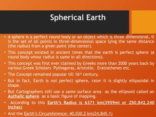
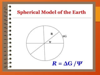
Spherical Earth
• Asphere is a perfect round body or an object which is three dimensional, It
is the set of all points in three-dimensional space lying the same distance
(the radius) from a given point (the center).
• This concept existed in ancient times that the earth is perfect sphere )a
round body whosr radius is same in all directions).
• This concept was first ever claimed by Greeks more than 2000 years back by
various Greek Scholars Pythagoras, Aristotle, Eratosthenes etc.
• The Concept remained popular till 16th
century.
• But in fact, Earth is not perfect sphere, rater it is slightly ellipsoidal in
shape.
• But Cartographers still use a same surface area as the ellipsoid called an
Authalic sphere as a basic figure of mapping.
• According to this Earth’s Radius is 6371 km(3959mi or 250,842,240
inches)
• And the Earth’s Circumference: 40,030.2 km(24,845.1)
8.
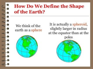
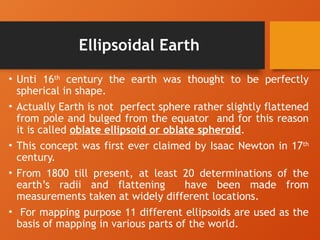
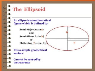
Ellipsoidal Earth
• Unti16th
century the earth was thought to be perfectly
spherical in shape.
• Actually Earth is not perfect sphere rather slightly flattened
from pole and bulged from the equator and for this reason
it is called oblate ellipsoid or oblate spheroid.
• This concept was first ever claimed by Isaac Newton in 17th
century.
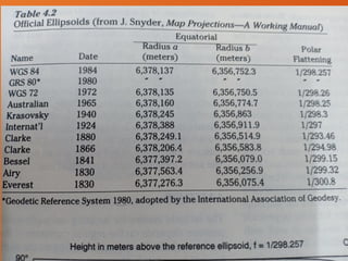
• From 1800 till present, at least 20 determinations of the
earth’s radii and flattening have been made from
measurements taken at widely different locations.
• For mapping purpose 11 different ellipsoids are used as the
basis of mapping in various parts of the world.
11.
Continued
• The WGS(world Geodetic Systems) 72 and WGS 84 ellipsoids,
determined from satellite orbital data are considered more
accurate than the earkier ground measurement determinations.
• But they may not give the best fit for a particular part of the
earth.
• The Clarke 1866 ellipsoid, is based on measurements taken in
Europe, India , Peru,, Russia, and South Africa is of spherical
interest in the United States and has been used for mapping
until now,
• North American cartographers are now rapidly switching to the
WGS84 elliposoid, which is considered to be a global standard
now.
12.
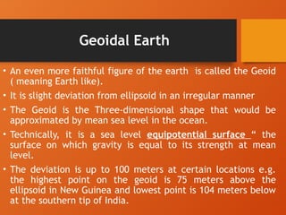
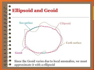
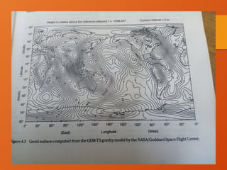
Geoidal Earth
• Aneven more faithful figure of the earth is called the Geoid
( meaning Earth like).
• It is slight deviation from ellipsoid in an irregular manner
• The Geoid is the Three-dimensional shape that would be
approximated by mean sea level in the ocean.
• Technically, it is a sea level equipotential surface “ the
surface on which gravity is equal to its strength at mean
level.
• The deviation is up to 100 meters at certain locations e.g.
the highest point on the geoid is 75 meters above the
ellipsoid in New Guinea and lowest point is 104 meters below
at the southern tip of India.
15.
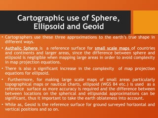
Cartographic use ofSphere,
Ellipsoid and Geoid
• Cartographers use these three approximations to the earth’s true shape in
different ways.
• Authalic Sphere is a reference surface for small scale maps of countries
and continents and larger areas, since the difference between sphere and
ellipsoid is negligible when mapping large areas in order to avoid complexity
in map projection equations.
• There is also a significant increase in the complexity of map projection
equations for ellipsoid.
• Furthermore, for making large scale maps of small areas particularly
topographical maps or nautical charts, ellipsoid (WGS 84 etc.) is used as a
reference surface as more accuracy is required and the difference between
between locations on the spherical and ellipsoidal approximations can be
significant, thus it important to take the earth oblateness into account.
• While as, Geoid is the reference surface for ground surveyed horizontal and
vertical positions and so on.


![International spheroid[1]](https://cdn.slidesharecdn.com/ss_thumbnails/internationalspheroid1-130817100358-phpapp02-thumbnail.jpg?width=640&height=640&fit=bounds)


