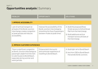
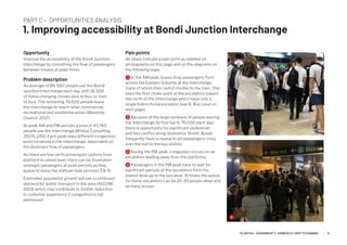
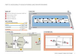
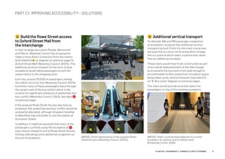
ASSIGNMENT 2 – MAY 2019
Auditing the
interchange
Kimberley Crofts – z3199999
PART A
What is the Interchange?
Definition of ‘the interchange’
According to Transport for London, the
word ‘interchange’ has multiple definitions.
They distinguish between the act of changing
modes (to interchange), the purpose-built
interchange facility where the change of
modes takes place, and a wider interchange
zone which might be a hub of other
interchange facilities (Transport for London,
2009) .
Role of interchanges within a transport
system
Interchanges are categorised as 'nodal
infrastructure' within the wider network and
systems of public infrastructure (Australian
Transport Council, 2006). Interchanges are
key nodes within a larger transport network
which enable the streamlining of modal
changes (Hernandez, Monzon & de Ona,
2016).
Importance of interchanges to different
stakeholders:
i. Transport Planners: Interchanges are a
key tool for a transport planner in optimising
the network, facilitating seamless modal
transfers, increased connectivity, and helping
to achieve satisfaction of public transport
users in the system (Nathanail et al., 2018).
ii. Government / Politicians: From a
governmental and political perspective,
interchanges provide multiple benefits.
As sites of easier modal transfer they offer
the public greater mobility (social), encourage
public transport use (environmental), and a
place for urban renewal (social and economic).
iii. Public Transport users: Interchanges
provide public transport users with a
convenient transfer/connection point to a
different mode on a multi-mode journey.
2PLAN7145 – ASSIGNMENT 2 –KIMBERLEY CROFTS Z3199999
PART B
Interchange Survey | Transport attributes
Bondi Junction Interchange is a purpose-built
facility in operation since 2001 which allows
for modal transfer between heavy rail in
(Eastern Suburbs line) and buses.
The transport attributes of the interchange
are listed in the table.
MODE DESCRIPTION SERVICE PATTERNS ESTIMATED USE
BUS All buses other than the
333 and the 380 terminate
at Bondi Junction (these
services travel through to
the CBD). Approximately
29 eastern suburbs
bus services utilise the
Interchange (Waverley
Council, 2017b, p22)
Rapid, express and all-stop
services. High frequency
in peak periods. All day
frequencies in off-peak
periods. Fewer services in
late evenings (333 late night
bus runs all night from the
CBD to Bondi Beach).
An estimated 53 buses
arrive at Bondi Junction
Interchange in the AM peak
between 7am and 9am. In
the evenings, 65 leave the
interchange between 5pm
and 7pm (AECOM, 2013).
TRAIN Only rail link to Waverley
LGA. Services to and from
Bondi Junction are the South
Cost Line (Wollongong,
Dapto, Kiama, etc) and the
T4 line to Cronulla, Waterfall
and Helensburgh.
Approximately 17 trains per
hour in morning peak, and 16
per hour in afternoon peak.
First weekday train from
Bondi Junction at 4:55am,
last to arrive in the evenings
is 1:02am (TfNSW).
64% of train patronage
occurs during AM and PM
peak periods. Average of
43,760 people use the train
station per day (Bitzios
Consulting, 2017b, p50).
CYCLING Bondi Junction has limited
bicycle parking (Grafton St).
There is estimated demand
for an extra 800 bicycle
parking stations (Waverley
Council, 2017b, p22).
n/a 2% of people arriving at the
station on a weekday do so
by bike.
KISS-AND-RIDE Car passenger drop off and
pick up point on Grafton
Street at Eastern end near
bus drop off zone
n/a High use in morning AM
peak causes congestion
along Grafton Street
where buses are letting off
passengers switching mode
to train.
3PLAN7145 – ASSIGNMENT 2 –KIMBERLEY CROFTS Z3199999
PART B
Interchange Survey | Land use attributes
Bondi Junction’s land use is predominantly high
density with a mix of commercial, retail and
residential (Waverley Council, 2017a). The area
is contained mostly between Ebley Street to the
south and Syd Einfield Drive to the north.The
Greater Sydney Commission's objectives for the
area set out in the document A Plan for Growing
Sydney, identifies Bondi Junction and the corridor
to Bondi Beach as potential areas for future
employment growth (Greater Sydney Commission,
2014). Future development is likely to continue to
the south of the core commercial centre (Bitzios
Consulting, 2017).
RESIDENTIAL: High density residential
development (R4) has dominated the area over
the recent period, with many residences along the
Oxford Street spine reaching over 10 stories (NSW
Department of Planning, 2010; Waverley Council,
2017a). Medium Density Residential (R3) is located
to the south of the main retail core.
RETAIL & COMMERCIAL: Commercial Core B3
zoning extends along the Oxford Street Pedestrian
mall and to the edge of The Westfield Shopping
Centre immediately adjacent to the Bondi Junction
Interchange. Adjacent zonings for B4 Mixed Use
development run at the western edge of Oxford
Street, and along Spring Street and Bronte Road
to the south of Oxford Street (NSW Department of
Planning, 2010).
The Waverley Local Environmental Plan (2010)
states that developments in the B3 commercial
core should reinforce the status of Bondi Junction
Land Use Map (Waverley
Local Environment Plan,
2010)
railway and bus interchange "as a major passenger
transport facility, including visual enhancement of
the surrounding environment and station entry".
In addition, the plan states that developers should
provide for "direct, convenient and safe pedestrian
links between the station concourse and bus
interchange level of Bondi Junction railway station
and Oxford Street Mall" (NSW Department of
Planning, 2010).
DEVELOPMENT INFLUENCES: The NSW
Government Architect has been working with
Waverley Council to develop concepts focussing
on the western edge of Oxford Street (Waverley
Council, 2015). The West Oxford Street Precinct
Plan concerns land currently zoned SP2
Infrastructure along Syd Einfeld Drive and at the
location of the Waverley Bus Depot. This location
has been the site of recent controversy over plans
to build a high density residential apartments.
SW PARKING SPACE LEVY: Development control
plans in place for Bondi Junction restrict the supply
of additional car parking in the area. Additionally,
each parking space in the commercial zone
contributes $840 per annum to the NSW Parking
Space Levy which is used to fund public transport
projects (Waverley Council, 2017a).The major retail
centres in the area have cumulative parking for over
4,000 vehicles (Westfield, 2019, Park Me, 2019).
4PLAN7145 – ASSIGNMENT 2 –KIMBERLEY CROFTS Z3199999
Lack of vertical transport at
all levels of the Bondi Junction
Interchange creates congestion
at peak periods and reduces
accessibility.
There is significant congestion
at Bondi Junction interchange as
passengers alight from the train
to catch buses to Bondi Beach,
especially during summer and
event periods.
PROBLEM
2. IMPROVE CUSTOMER EXPERIENCE
1. IMPROVE ACCESSIBILITY
OPPORTUNITY SOLUTIONS
Improve the accessibility of the
Bondi Junction interchange by
smoothing the flow of passengers
between modes at peak times.
Enhance both the tourist
and commuter experience of
travelling to Bondi Beach.
A. Build the proposed Rowe
Street access to Oxford Street
Mall from the Interchange.
B. Build additional vertical
transport across all levels of
the Interchange.
A. Build light rail to Bondi Beach
B. bus from CBD to Bondi Beach
that avoids Bondi Junction.
PART C
Opportunities analysis | Summary
5PLAN7145 – ASSIGNMENT 2 –KIMBERLEY CROFTS Z3199999
PART C – OPPORTUNITIES ANALYSIS
1. Improving accessibility at Bondi Junction Interchange
Opportunity
Improve the accessibility of the Bondi Junction
interchange by smoothing the flow of passengers
between modes at peak times.
Problem description
An average of 86,500 people use the Bondi
Junction Interchange each day, with 16,500
of these changing modes (bus to bus, or train
to bus). The remaining 70,000 people leave
the Interchange to reach retail, commercial,
recreational and residential areas (Waverley
Council, 2017).
At peak AM and PM periods a total of 43,760
people use the Interchange (Bitzios Consulting,
2017b, p50). Each peak sees different congestion
point locations in the Interchange, dependent on
the dominant flow of passengers.
As there are few vertical transport options from
platform to street level, there can be frustration
amongst passengers at peak periods as they
queue to leave the statioan (see pictures 3  4).
Estimated population growth will see a continued
demand for public transport in the area (AECOM,
2013) which may contribute to further reduction
in customer experience if congestion is not
addressed.
Pain points
All labels indicate a pain point as labelled on
photographs on this page and on the diagrams on
the following page.
1 In the AM peak, buses drop passengers from
across the Eastern Suburbs at the Interchange,
many of whom then switch modes to the train. This
sees the first choke point at the escalators toward
the north of the Interchange which have only a
single bidirectional escalator (see B. Bus Level on
next page).
2 Because of the large numbers of people leaving
the Interchange by foot (up to 70,000 each day)
there is opportunity for significant pedestrian
and bus conflict along Grosvenor Street. Buses
frequently have to queue to let passengers cross
over the exit to the bus station.
3 During the PM peak, congestion occurs on all
escalators leading away from the platforms.
4 Passengers in the PM peak have to wait for
significant periods at the escalators from the
station level up to the bus level. At times the queue
for these escalators can be 20-30 people deep and
as many across.
3
4
6PLAN7145 – ASSIGNMENT 2 –KIMBERLEY CROFTS Z3199999
PART C1: ACCESSIBILITY ISSUES AT BONDI JUNCTION INTERCHANGE
C. STATION LEVEL D. PLATFORM LEVEL
B. BUS LEVEL
DOWNTOPLATFORMS
UPTOSTATIONLEVEL
STAIRSTOGRAFTONSTREET
LIFTTO
PLATFORMS
LIFTTO
STATIONLEVEL
LIFTTO
SHOPPING
LEVEL
STAIRSRAMPTOGRAFTONST
DUALESCALATORS
TOBUSLEVEL
PLATFORM1
PLATFORM2
SINGLEESCALATOR
STAIRSTOBUSLEVEL
ESCALATORDOWN
TOPLATFORMS PEDESTRIAN
EXITUPTO
SHOPPINGLEVEL
LIFTTOPLATFORMS
SHOPPINGLEVEL
DOWNTO
STATION
ENTRANCE
GRAFTONSTREET
GROSVENORLANE
NEWLANDSTREET
GROSVENORSTREET
H
G F E D C B A
J K L M N P
ALL DIAGRAMS BASED ON OFFICIAL MAPS FROM TRANSPORT FOR NSW
1A
1B
1B
1
2
4
3
3
SIDE ELEVATION
A. SHOPPING CENTRE AND BONDI JUNCTION MALL
B. BUS LEVEL
C. STATION ENTRANCE
D. PLATFORM LEVEL
ISSUES LIST
1 Choke point AM peak as passengers alight bus
2 Pedestrian/bus conflict
3 Choke point PM peak
4 Choke points PM peak
7PLAN7145 – ASSIGNMENT 2 –KIMBERLEY CROFTS Z3199999
1A Build the Rowe Street access
to Oxford Street Mall from
the Interchange
In their strategy document People, Movement
and Places, Waverley Council has proposed to
make a more direct connection from the station
level (labelled 1A on diagram on previous page) to
Oxford Street Mall (Waverley Council, 2017b). This
additional vertical transport (in the form of dual
escalators) would allow passengers to exit the
station direct to the shopping zone.
Each day, around 70,000 of passengers exiting
the station do so by foot (Waverley Council 2017b).
Currently, many of these passengers leave through
the eastern exit of the bus station which is the
location for significant instances of pedestrian and
bus conflict (Waverley Council, 2013). See label 2
on previous page.
If the propose Rowe Street Access was built as
proposed, this pedestrian and bus conflict would be
somewhat alleviated, although shoppers heading
to Westfield may still prefer to exit the station at
Grosvenor Street.
In addition, it might be assumed that many of the
passengers currently using the escalators at 4
may choose instead to exit at Rowe Street Access
thereby alleviating some additional congestion at
this set of escalators.
1B Additional vertical transport
To alleviate AM and PM passenger congestion
at escalators I propose that additional vertical
transport be built. Point 4 is the most crucial and,
because this is a short vertical elevation change,
this is a point at which stairs could be built rather
than an additional escalator.
These stairs would have to be constructed as part
of an overall redevelopment of the interchange
as at present the bus level is not wide enough to
accommodate further pedestrian circulation space
being taken up by vertical transport (see label C2
on 'B. Bus Level' diagram on previous page).
The stairs would provide an active option for
passengers on top of the existing escalators.
PART C1: IMPROVING ACCESSIBILITY – SOLUTIONS
ABOVE: Artist impressions of the propose Rowe
Street Access (Waverley Council, 2017b).
ABOVE: Stairs could be built adjacent to current
escalators to eastern end of station level
(Kimberley Crofts, 2019).
8PLAN7145 – ASSIGNMENT 2 –KIMBERLEY CROFTS Z3199999
PART C – OPPORTUNITIES ANALYSIS
2. Improving customer experience at Bondi Junction Interchange
Opportunity
Enhance the visitor and commuter experience of
travelling to Bondi Beach.
Problem description
Bondi Beach is one of Sydney's most popular
tourist destinations. It is estimated over 50,000
visitors visit Bondi Beach per day (AECOM, 2013).
There is significant congestion at Bondi Junction
interchange as passengers alight from the train to
catch buses to Bondi Beach. The queues for the
333 bus from the Interchange (seen in photo to
right) can be significant during the PM peak, and at
all times during the day through summer time and
event peaks. With the additional numbers of people
travelling to events and the beach, there can be
significant delays for local residents when waiting
for a bus connection at the interchange.
Additionally, poorly designed road links from the
Interchange out to Bondi Road sees significant
'bunching' of buses form at PM peak periods,
further contributing to queues of passengers as
frequency of buses is restricted.
Wayfinding in the Interchange is also poor.
Typography indicating destination of the key routes
(333 and 380) is small and secondary to the stop
label (see A in the top centre of photo to the right).
Tourists can easily be confused as to where to
catch the bus to the beach.
ABOVE: Passengers waiting for the 333 bus at PM peak (Kimberley Crofts, 2019).
9PLAN7145 – ASSIGNMENT 2 –KIMBERLEY CROFTS Z3199999
Solutions overview
To improve customer experience at
the Bondi Junction Interchange it is
necessary to increase the capacity
of transport out of the Interchange,
particularly at peak periods.
There are two proposals here: build
a higher capacity link from Bondi
Junction to the beach in the form
of light rail (C3), and reduce the
numbers of commuters travelling
through the Interchange at AM and
PM peak by introducing a rapid bus
that allows commuting passengers
to avoid the Interchange (C4).
2A Build light rail to Bondi Beach
Waverley Council commissioned AECOM in 2013 to
undertake a feasibility study of constructing a light
rail service from Bondi Junction to Bondi Beach. In
this study it was shown that the most suitable route
would be along Bondi Road as this would achieve
the highest passenger numbers—some 14,800 per
day based on 2011 patronage (AECOM, 2013).
There would be multiple benefits of building a light
rail to Bondi Beach:
1. Value capture: Potential for significant uplift
in commercial and retail opportunities along the
Bondi Road. With a value capture financing model,
levies could be imposed on developers to finance
some of the construction.
2. Reduced congestion. The light rail would
be capable of transporting significantly more
passengers than the existing bus service and would
take up less road space than buses. According to
and AECOM study, light rail can carry up to 300
people per set using 50% less road space, while
buses take from 60 to 100 depending on the type
of bus (AECOM, 2013).
3. Reduce journey times. A faster journey has been
estimated by AECOM. The current journey by bus
takes approximately 14 minutes at peak periods
but would be just over 7 minutes via light rail
(AECOM, 2013).
2B Rapid bus from CBD to Bondi
Beach that avoids Bondi Junction
Creating a rapid bus route that avoids Bondi
Junction Interchange would improve both
commuter experience and tourist experience.
Commuters taking the rapid bus from the city
would avoid Bondi Junction Interchange. This new
route would be preferable as the mode switching
would not be necessary to achieve a similar travel
time from Bondi Beach to the CBD (see table).
Because congestion at the Bondi Junction
Interchange would be reduced during AM and PM
peaks, the Interchange would become more legible
for tourists.
BUS ROUTE TIME
AM PEAK
333 from Bondi Beach to CBD (existing) 54 mins
333 + Train from Bondi to CBD (existing) 46 mins
Rapid bus from Bondi to the CBD (new) 44 mins
PM PEAK
333 from CBD to Bondi (existing) 44 mins
333 + Train from CBD to Bondi (existing) 37 mins
Rapid bus from CBD to Bondi (new) 34 mins
A map showing the proposed route is on the
following page.
PART C: IMPROVING CUSTOMER EXPERIENCE – SOLUTIONS
10PLAN7145 – ASSIGNMENT 2 –KIMBERLEY CROFTS Z3199999
EXISTING ROUTE
Buses enter Bondi
Junction commercial
zone to pick up and drop
off passengers at the
Interchange.
PROPOSED ROUTE
Buses in both directions
take Sid Einfield Drive and
avoid Bondi Junction. There
would need to be some
reduction in regular services
to ensure there was not
additional congestion along
the Bondi Road corridor.
ALTERNATIVE ROUTE
As an alternative for
morning travel to the
CBD, buses could take
Moore Park Road and then
Eastern Distributor. Similar
to some express services
from Anzac Parade.
PART C: IMPROVING CUSTOMER EXPERIENCE – SOLUTIONS
AECOM 2013, Waverley Light Rail, AECOM, Sydney.
Australian Transport Council 2006, National Guidelines for Transport System
	 Management in Australia.
Bitzios Consulting 2017a, Waverley’s People, Movement and Places:
	 Final Strategy Report, Waverley Council.
Bitzios Consulting 2017b, Waverley’s People, Movement and Places:
	 Key issues report, Waverley Council.
Hernandez, S., Monzon, A.  de Ona, R. 2016, Urban transport interchanges:
	 A methodology for evaluating perceived quality, Transportation Research
	 Part A-Policy And Practice, vol. 84, pp. 31-43.
Nathanail, E., Adamos, G., Tsami, M.  Yatskiv, I. 2018, Green Urban Interchanges:
	 Stakeholder and User Perspectives, Transport and Telecommunication
	Journal, vol. 19, no. 3, pp. 183-193.
NSW Department of Planning 2010, Waverley Local Environmental Plan
	 (Bondi Junction Centre).
Park Me 2019, Eastgate Shopping Centre. Available: www.parkme.com/
	 en-au/lot/110395/eastgate-car-park-sydney-australia [2019, 20 April,].
TfNSW, 2019, T4 – Eastern Suburbs to Illawarra timetable. Available: transportnsw.
	 info/routes/details/sydney-trains/t4/020t4 [2019, April 20,].
Transport for London 2009, Interchange Best Practice Guidelines.
Waverley Council 2017a, Bondi Road Corridor Transport Strategy.
Waverley Council 2017b, Waverley’s People, Movement and Places.
Waverley Council 2013, Bondi Junction Complete Streets.
Waverley Council 2015, West Oxford Street Design Charette Summary Report
	 and Recommendations
Westfield 2019, Westfield Bondi Junction parking. Available: www.westfield.com
	 au/bondijunction/service [2019, April 20].
References
12PLAN7145 – ASSIGNMENT 2 –KIMBERLEY CROFTS Z3199999

Auditing the interchange

  • 1.
    ASSIGNMENT 2 –MAY 2019 Auditing the interchange Kimberley Crofts – z3199999
  • 2.
    PART A What isthe Interchange? Definition of ‘the interchange’ According to Transport for London, the word ‘interchange’ has multiple definitions. They distinguish between the act of changing modes (to interchange), the purpose-built interchange facility where the change of modes takes place, and a wider interchange zone which might be a hub of other interchange facilities (Transport for London, 2009) . Role of interchanges within a transport system Interchanges are categorised as 'nodal infrastructure' within the wider network and systems of public infrastructure (Australian Transport Council, 2006). Interchanges are key nodes within a larger transport network which enable the streamlining of modal changes (Hernandez, Monzon & de Ona, 2016). Importance of interchanges to different stakeholders: i. Transport Planners: Interchanges are a key tool for a transport planner in optimising the network, facilitating seamless modal transfers, increased connectivity, and helping to achieve satisfaction of public transport users in the system (Nathanail et al., 2018). ii. Government / Politicians: From a governmental and political perspective, interchanges provide multiple benefits. As sites of easier modal transfer they offer the public greater mobility (social), encourage public transport use (environmental), and a place for urban renewal (social and economic). iii. Public Transport users: Interchanges provide public transport users with a convenient transfer/connection point to a different mode on a multi-mode journey. 2PLAN7145 – ASSIGNMENT 2 –KIMBERLEY CROFTS Z3199999
  • 3.
    PART B Interchange Survey| Transport attributes Bondi Junction Interchange is a purpose-built facility in operation since 2001 which allows for modal transfer between heavy rail in (Eastern Suburbs line) and buses. The transport attributes of the interchange are listed in the table. MODE DESCRIPTION SERVICE PATTERNS ESTIMATED USE BUS All buses other than the 333 and the 380 terminate at Bondi Junction (these services travel through to the CBD). Approximately 29 eastern suburbs bus services utilise the Interchange (Waverley Council, 2017b, p22) Rapid, express and all-stop services. High frequency in peak periods. All day frequencies in off-peak periods. Fewer services in late evenings (333 late night bus runs all night from the CBD to Bondi Beach). An estimated 53 buses arrive at Bondi Junction Interchange in the AM peak between 7am and 9am. In the evenings, 65 leave the interchange between 5pm and 7pm (AECOM, 2013). TRAIN Only rail link to Waverley LGA. Services to and from Bondi Junction are the South Cost Line (Wollongong, Dapto, Kiama, etc) and the T4 line to Cronulla, Waterfall and Helensburgh. Approximately 17 trains per hour in morning peak, and 16 per hour in afternoon peak. First weekday train from Bondi Junction at 4:55am, last to arrive in the evenings is 1:02am (TfNSW). 64% of train patronage occurs during AM and PM peak periods. Average of 43,760 people use the train station per day (Bitzios Consulting, 2017b, p50). CYCLING Bondi Junction has limited bicycle parking (Grafton St). There is estimated demand for an extra 800 bicycle parking stations (Waverley Council, 2017b, p22). n/a 2% of people arriving at the station on a weekday do so by bike. KISS-AND-RIDE Car passenger drop off and pick up point on Grafton Street at Eastern end near bus drop off zone n/a High use in morning AM peak causes congestion along Grafton Street where buses are letting off passengers switching mode to train. 3PLAN7145 – ASSIGNMENT 2 –KIMBERLEY CROFTS Z3199999
  • 4.
    PART B Interchange Survey| Land use attributes Bondi Junction’s land use is predominantly high density with a mix of commercial, retail and residential (Waverley Council, 2017a). The area is contained mostly between Ebley Street to the south and Syd Einfield Drive to the north.The Greater Sydney Commission's objectives for the area set out in the document A Plan for Growing Sydney, identifies Bondi Junction and the corridor to Bondi Beach as potential areas for future employment growth (Greater Sydney Commission, 2014). Future development is likely to continue to the south of the core commercial centre (Bitzios Consulting, 2017). RESIDENTIAL: High density residential development (R4) has dominated the area over the recent period, with many residences along the Oxford Street spine reaching over 10 stories (NSW Department of Planning, 2010; Waverley Council, 2017a). Medium Density Residential (R3) is located to the south of the main retail core. RETAIL & COMMERCIAL: Commercial Core B3 zoning extends along the Oxford Street Pedestrian mall and to the edge of The Westfield Shopping Centre immediately adjacent to the Bondi Junction Interchange. Adjacent zonings for B4 Mixed Use development run at the western edge of Oxford Street, and along Spring Street and Bronte Road to the south of Oxford Street (NSW Department of Planning, 2010). The Waverley Local Environmental Plan (2010) states that developments in the B3 commercial core should reinforce the status of Bondi Junction Land Use Map (Waverley Local Environment Plan, 2010) railway and bus interchange "as a major passenger transport facility, including visual enhancement of the surrounding environment and station entry". In addition, the plan states that developers should provide for "direct, convenient and safe pedestrian links between the station concourse and bus interchange level of Bondi Junction railway station and Oxford Street Mall" (NSW Department of Planning, 2010). DEVELOPMENT INFLUENCES: The NSW Government Architect has been working with Waverley Council to develop concepts focussing on the western edge of Oxford Street (Waverley Council, 2015). The West Oxford Street Precinct Plan concerns land currently zoned SP2 Infrastructure along Syd Einfeld Drive and at the location of the Waverley Bus Depot. This location has been the site of recent controversy over plans to build a high density residential apartments. SW PARKING SPACE LEVY: Development control plans in place for Bondi Junction restrict the supply of additional car parking in the area. Additionally, each parking space in the commercial zone contributes $840 per annum to the NSW Parking Space Levy which is used to fund public transport projects (Waverley Council, 2017a).The major retail centres in the area have cumulative parking for over 4,000 vehicles (Westfield, 2019, Park Me, 2019). 4PLAN7145 – ASSIGNMENT 2 –KIMBERLEY CROFTS Z3199999
  • 5.
    Lack of verticaltransport at all levels of the Bondi Junction Interchange creates congestion at peak periods and reduces accessibility. There is significant congestion at Bondi Junction interchange as passengers alight from the train to catch buses to Bondi Beach, especially during summer and event periods. PROBLEM 2. IMPROVE CUSTOMER EXPERIENCE 1. IMPROVE ACCESSIBILITY OPPORTUNITY SOLUTIONS Improve the accessibility of the Bondi Junction interchange by smoothing the flow of passengers between modes at peak times. Enhance both the tourist and commuter experience of travelling to Bondi Beach. A. Build the proposed Rowe Street access to Oxford Street Mall from the Interchange. B. Build additional vertical transport across all levels of the Interchange. A. Build light rail to Bondi Beach B. bus from CBD to Bondi Beach that avoids Bondi Junction. PART C Opportunities analysis | Summary 5PLAN7145 – ASSIGNMENT 2 –KIMBERLEY CROFTS Z3199999
  • 6.
    PART C –OPPORTUNITIES ANALYSIS 1. Improving accessibility at Bondi Junction Interchange Opportunity Improve the accessibility of the Bondi Junction interchange by smoothing the flow of passengers between modes at peak times. Problem description An average of 86,500 people use the Bondi Junction Interchange each day, with 16,500 of these changing modes (bus to bus, or train to bus). The remaining 70,000 people leave the Interchange to reach retail, commercial, recreational and residential areas (Waverley Council, 2017). At peak AM and PM periods a total of 43,760 people use the Interchange (Bitzios Consulting, 2017b, p50). Each peak sees different congestion point locations in the Interchange, dependent on the dominant flow of passengers. As there are few vertical transport options from platform to street level, there can be frustration amongst passengers at peak periods as they queue to leave the statioan (see pictures 3 4). Estimated population growth will see a continued demand for public transport in the area (AECOM, 2013) which may contribute to further reduction in customer experience if congestion is not addressed. Pain points All labels indicate a pain point as labelled on photographs on this page and on the diagrams on the following page. 1 In the AM peak, buses drop passengers from across the Eastern Suburbs at the Interchange, many of whom then switch modes to the train. This sees the first choke point at the escalators toward the north of the Interchange which have only a single bidirectional escalator (see B. Bus Level on next page). 2 Because of the large numbers of people leaving the Interchange by foot (up to 70,000 each day) there is opportunity for significant pedestrian and bus conflict along Grosvenor Street. Buses frequently have to queue to let passengers cross over the exit to the bus station. 3 During the PM peak, congestion occurs on all escalators leading away from the platforms. 4 Passengers in the PM peak have to wait for significant periods at the escalators from the station level up to the bus level. At times the queue for these escalators can be 20-30 people deep and as many across. 3 4 6PLAN7145 – ASSIGNMENT 2 –KIMBERLEY CROFTS Z3199999
  • 7.
    PART C1: ACCESSIBILITYISSUES AT BONDI JUNCTION INTERCHANGE C. STATION LEVEL D. PLATFORM LEVEL B. BUS LEVEL DOWNTOPLATFORMS UPTOSTATIONLEVEL STAIRSTOGRAFTONSTREET LIFTTO PLATFORMS LIFTTO STATIONLEVEL LIFTTO SHOPPING LEVEL STAIRSRAMPTOGRAFTONST DUALESCALATORS TOBUSLEVEL PLATFORM1 PLATFORM2 SINGLEESCALATOR STAIRSTOBUSLEVEL ESCALATORDOWN TOPLATFORMS PEDESTRIAN EXITUPTO SHOPPINGLEVEL LIFTTOPLATFORMS SHOPPINGLEVEL DOWNTO STATION ENTRANCE GRAFTONSTREET GROSVENORLANE NEWLANDSTREET GROSVENORSTREET H G F E D C B A J K L M N P ALL DIAGRAMS BASED ON OFFICIAL MAPS FROM TRANSPORT FOR NSW 1A 1B 1B 1 2 4 3 3 SIDE ELEVATION A. SHOPPING CENTRE AND BONDI JUNCTION MALL B. BUS LEVEL C. STATION ENTRANCE D. PLATFORM LEVEL ISSUES LIST 1 Choke point AM peak as passengers alight bus 2 Pedestrian/bus conflict 3 Choke point PM peak 4 Choke points PM peak 7PLAN7145 – ASSIGNMENT 2 –KIMBERLEY CROFTS Z3199999
  • 8.
    1A Build theRowe Street access to Oxford Street Mall from the Interchange In their strategy document People, Movement and Places, Waverley Council has proposed to make a more direct connection from the station level (labelled 1A on diagram on previous page) to Oxford Street Mall (Waverley Council, 2017b). This additional vertical transport (in the form of dual escalators) would allow passengers to exit the station direct to the shopping zone. Each day, around 70,000 of passengers exiting the station do so by foot (Waverley Council 2017b). Currently, many of these passengers leave through the eastern exit of the bus station which is the location for significant instances of pedestrian and bus conflict (Waverley Council, 2013). See label 2 on previous page. If the propose Rowe Street Access was built as proposed, this pedestrian and bus conflict would be somewhat alleviated, although shoppers heading to Westfield may still prefer to exit the station at Grosvenor Street. In addition, it might be assumed that many of the passengers currently using the escalators at 4 may choose instead to exit at Rowe Street Access thereby alleviating some additional congestion at this set of escalators. 1B Additional vertical transport To alleviate AM and PM passenger congestion at escalators I propose that additional vertical transport be built. Point 4 is the most crucial and, because this is a short vertical elevation change, this is a point at which stairs could be built rather than an additional escalator. These stairs would have to be constructed as part of an overall redevelopment of the interchange as at present the bus level is not wide enough to accommodate further pedestrian circulation space being taken up by vertical transport (see label C2 on 'B. Bus Level' diagram on previous page). The stairs would provide an active option for passengers on top of the existing escalators. PART C1: IMPROVING ACCESSIBILITY – SOLUTIONS ABOVE: Artist impressions of the propose Rowe Street Access (Waverley Council, 2017b). ABOVE: Stairs could be built adjacent to current escalators to eastern end of station level (Kimberley Crofts, 2019). 8PLAN7145 – ASSIGNMENT 2 –KIMBERLEY CROFTS Z3199999
  • 9.
    PART C –OPPORTUNITIES ANALYSIS 2. Improving customer experience at Bondi Junction Interchange Opportunity Enhance the visitor and commuter experience of travelling to Bondi Beach. Problem description Bondi Beach is one of Sydney's most popular tourist destinations. It is estimated over 50,000 visitors visit Bondi Beach per day (AECOM, 2013). There is significant congestion at Bondi Junction interchange as passengers alight from the train to catch buses to Bondi Beach. The queues for the 333 bus from the Interchange (seen in photo to right) can be significant during the PM peak, and at all times during the day through summer time and event peaks. With the additional numbers of people travelling to events and the beach, there can be significant delays for local residents when waiting for a bus connection at the interchange. Additionally, poorly designed road links from the Interchange out to Bondi Road sees significant 'bunching' of buses form at PM peak periods, further contributing to queues of passengers as frequency of buses is restricted. Wayfinding in the Interchange is also poor. Typography indicating destination of the key routes (333 and 380) is small and secondary to the stop label (see A in the top centre of photo to the right). Tourists can easily be confused as to where to catch the bus to the beach. ABOVE: Passengers waiting for the 333 bus at PM peak (Kimberley Crofts, 2019). 9PLAN7145 – ASSIGNMENT 2 –KIMBERLEY CROFTS Z3199999
  • 10.
    Solutions overview To improvecustomer experience at the Bondi Junction Interchange it is necessary to increase the capacity of transport out of the Interchange, particularly at peak periods. There are two proposals here: build a higher capacity link from Bondi Junction to the beach in the form of light rail (C3), and reduce the numbers of commuters travelling through the Interchange at AM and PM peak by introducing a rapid bus that allows commuting passengers to avoid the Interchange (C4). 2A Build light rail to Bondi Beach Waverley Council commissioned AECOM in 2013 to undertake a feasibility study of constructing a light rail service from Bondi Junction to Bondi Beach. In this study it was shown that the most suitable route would be along Bondi Road as this would achieve the highest passenger numbers—some 14,800 per day based on 2011 patronage (AECOM, 2013). There would be multiple benefits of building a light rail to Bondi Beach: 1. Value capture: Potential for significant uplift in commercial and retail opportunities along the Bondi Road. With a value capture financing model, levies could be imposed on developers to finance some of the construction. 2. Reduced congestion. The light rail would be capable of transporting significantly more passengers than the existing bus service and would take up less road space than buses. According to and AECOM study, light rail can carry up to 300 people per set using 50% less road space, while buses take from 60 to 100 depending on the type of bus (AECOM, 2013). 3. Reduce journey times. A faster journey has been estimated by AECOM. The current journey by bus takes approximately 14 minutes at peak periods but would be just over 7 minutes via light rail (AECOM, 2013). 2B Rapid bus from CBD to Bondi Beach that avoids Bondi Junction Creating a rapid bus route that avoids Bondi Junction Interchange would improve both commuter experience and tourist experience. Commuters taking the rapid bus from the city would avoid Bondi Junction Interchange. This new route would be preferable as the mode switching would not be necessary to achieve a similar travel time from Bondi Beach to the CBD (see table). Because congestion at the Bondi Junction Interchange would be reduced during AM and PM peaks, the Interchange would become more legible for tourists. BUS ROUTE TIME AM PEAK 333 from Bondi Beach to CBD (existing) 54 mins 333 + Train from Bondi to CBD (existing) 46 mins Rapid bus from Bondi to the CBD (new) 44 mins PM PEAK 333 from CBD to Bondi (existing) 44 mins 333 + Train from CBD to Bondi (existing) 37 mins Rapid bus from CBD to Bondi (new) 34 mins A map showing the proposed route is on the following page. PART C: IMPROVING CUSTOMER EXPERIENCE – SOLUTIONS 10PLAN7145 – ASSIGNMENT 2 –KIMBERLEY CROFTS Z3199999
  • 11.
    EXISTING ROUTE Buses enterBondi Junction commercial zone to pick up and drop off passengers at the Interchange. PROPOSED ROUTE Buses in both directions take Sid Einfield Drive and avoid Bondi Junction. There would need to be some reduction in regular services to ensure there was not additional congestion along the Bondi Road corridor. ALTERNATIVE ROUTE As an alternative for morning travel to the CBD, buses could take Moore Park Road and then Eastern Distributor. Similar to some express services from Anzac Parade. PART C: IMPROVING CUSTOMER EXPERIENCE – SOLUTIONS
  • 12.
    AECOM 2013, WaverleyLight Rail, AECOM, Sydney. Australian Transport Council 2006, National Guidelines for Transport System Management in Australia. Bitzios Consulting 2017a, Waverley’s People, Movement and Places: Final Strategy Report, Waverley Council. Bitzios Consulting 2017b, Waverley’s People, Movement and Places: Key issues report, Waverley Council. Hernandez, S., Monzon, A. de Ona, R. 2016, Urban transport interchanges: A methodology for evaluating perceived quality, Transportation Research Part A-Policy And Practice, vol. 84, pp. 31-43. Nathanail, E., Adamos, G., Tsami, M. Yatskiv, I. 2018, Green Urban Interchanges: Stakeholder and User Perspectives, Transport and Telecommunication Journal, vol. 19, no. 3, pp. 183-193. NSW Department of Planning 2010, Waverley Local Environmental Plan (Bondi Junction Centre). Park Me 2019, Eastgate Shopping Centre. Available: www.parkme.com/ en-au/lot/110395/eastgate-car-park-sydney-australia [2019, 20 April,]. TfNSW, 2019, T4 – Eastern Suburbs to Illawarra timetable. Available: transportnsw. info/routes/details/sydney-trains/t4/020t4 [2019, April 20,]. Transport for London 2009, Interchange Best Practice Guidelines. Waverley Council 2017a, Bondi Road Corridor Transport Strategy. Waverley Council 2017b, Waverley’s People, Movement and Places. Waverley Council 2013, Bondi Junction Complete Streets. Waverley Council 2015, West Oxford Street Design Charette Summary Report and Recommendations Westfield 2019, Westfield Bondi Junction parking. Available: www.westfield.com au/bondijunction/service [2019, April 20]. References 12PLAN7145 – ASSIGNMENT 2 –KIMBERLEY CROFTS Z3199999