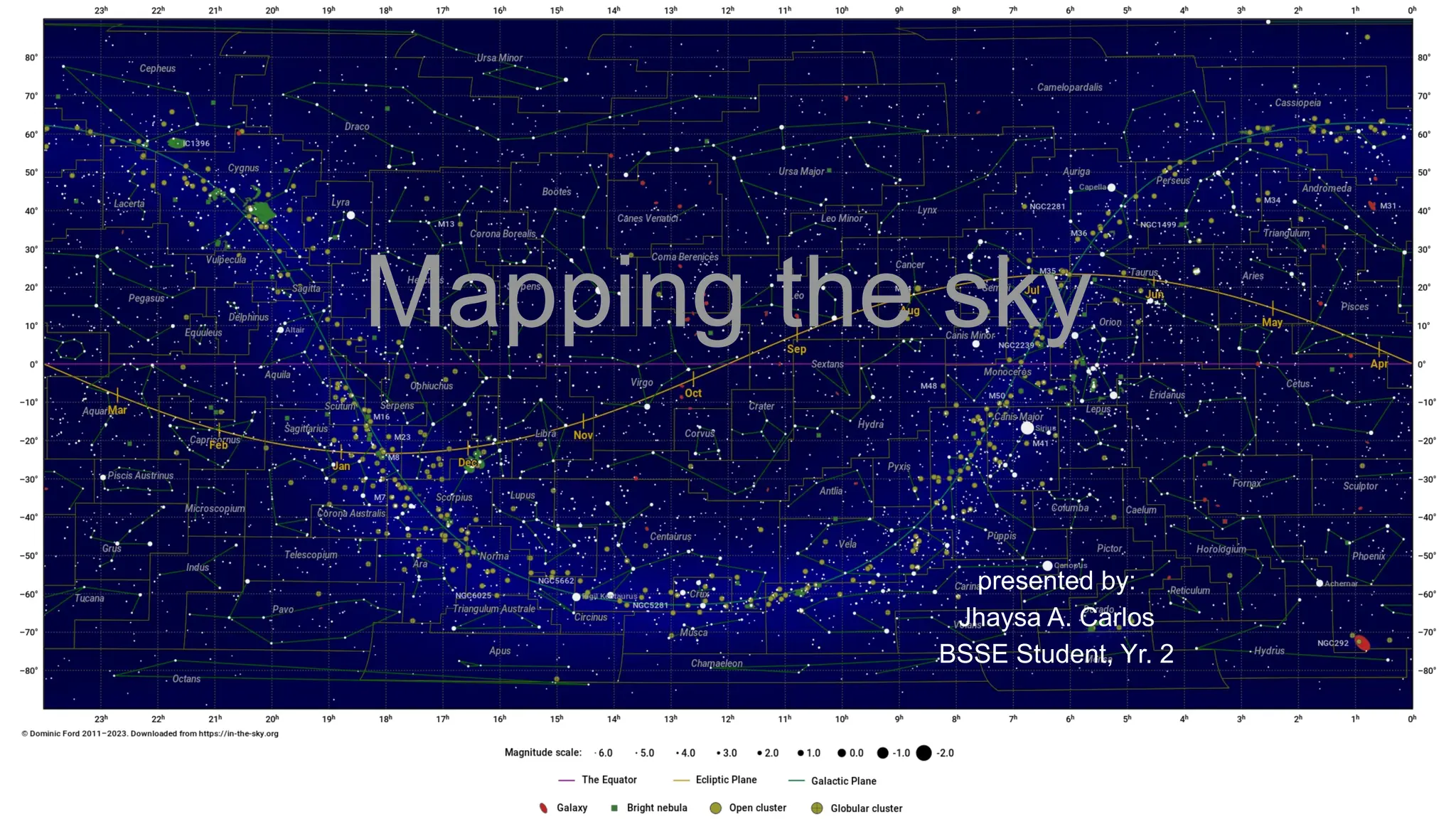
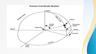
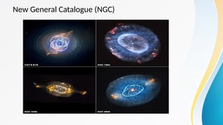
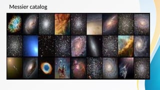
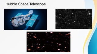
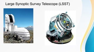
Mapping the sky
presented by:
Jhaysa A. Carlos
BSSE Student, Yr. 2
Objectives:
• The students will be able to define what sky
mapping is
• The students will be able to enumerate the different
aspects of sky mapping
• The students will be able to tell the importance of
sky mapping in astronomy
what is mapping the sky?
Mapping the sky refers to the process of
creating a systematic representation of the
celestial sphere, which is the apparent dome-
like structure of the sky as observed from Earth.
It involves establishing coordinate systems,
creating star charts, and cataloging celestial
objects to accurately locate and identify them.
Different aspects of mapping the
sky
1. Coordinate system
Celestial coordinate systems are used to define
the positions of celestial objects in the sky.
The two primary coordinate systems used in
astronomy are the equatorial and horizontal
systems.
A. The equatorial system uses declination and
right ascension, similar to latitude and longitude on
Earth, to specify the location of objects.
• Right Ascension (RA): Right ascension is
equivalent to longitude on Earth and measures the
angular distance of a celestial object eastward
along the celestial equator from a reference point
called the vernal equinox. It is expressed in hours,
minutes, and seconds, with a full circle of 24 hours
representing 360 degrees.
• Declination (Dec): Declination is equivalent to
latitude on Earth and measures the angular
distance of a celestial object north or south of the
celestial equator. It is expressed in degrees,
minutes, and seconds, with positive values for
objects north of the celestial equator and negative
values for objects south of it.
B. The horizontal system uses altitude and
azimuth, which are angles measured from the
observer's location, to describe the positions of
objects relative to the observer's horizon.
• Altitude (Alt): Altitude measures the angular
distance of a celestial object above the observer's
horizon. It is expressed in degrees, with 0 degrees
at the horizon and 90 degrees at the zenith
(directly overhead).
• Azimuth (Az): Azimuth measures the angular
distance of a celestial object along the observer's
horizon, starting from a reference point (usually
north) and going clockwise. It is expressed in
degrees, ranging from 0 to 360.
2. Star Charts or Sky Maps
Star charts are graphical representations of the
night sky. They depict the positions and brightness of
stars, constellations, and other celestial objects. Star
charts can be created for specific time periods,
locations, and observing conditions. They serve as
visual aids for astronomers and stargazers to
navigate the sky, identify objects, and plan
observations.
3. Catalogs and Databases
Astronomical catalogs are comprehensive
databases that contain information about celestial
objects. They include stars, galaxies, nebulae,
clusters, and other phenomena. Catalogs provide
designations, coordinates, magnitudes, spectral
classifications, and other relevant data for each
object. These catalogs are continuously updated
and serve as references for astronomers to study
and track celestial objects.
• Astronomers maintain catalogs and databases that
contain detailed information about celestial objects.
Examples include the Messier catalog, the New General
Catalogue (NGC), and the Sloan Digital Sky Survey
(SDSS). These resources help astronomers identify and
study specific objects in the sky.
New General Catalogue (NGC)
Messier catalog
4. Sky Surveys
Sky surveys involve systematically observing large
areas of the sky to create detailed maps. These
surveys use telescopes equipped with advanced
imaging technology to capture images of the sky. Sky
surveys provide vast amounts of data, allowing
astronomers to study the distribution of galaxies,
identify new objects, and detect transient events.
• Large-scale sky surveys systematically observe
and map the entire sky in various wavelengths of
light. Examples include the Hubble Space
Telescope's Deep Field surveys, the Sloan Digital
Sky Survey, and the upcoming Large Synoptic
Survey Telescope (LSST). These surveys provide
invaluable data for studying the universe on a
grand scale.
Hubble Space Telescope
Large Synoptic Survey Telescope (LSST)
what it captures
5. Digital Sky Mapping
With the advent of digital technology, sky mapping
has become more sophisticated. Digital sky mapping
involves the use of computer software and
databases to create interactive and customizable
representations of the sky. These digital maps allow
users to explore the night sky, zoom in on specific
regions, and access detailed information about
celestial objects.
Importance of mapping the sky
1. Celestial Navigation:
• Mapping the sky allows astronomers to navigate and
locate celestial objects accurately. By establishing
coordinate systems and creating star charts, astronomers
can pinpoint the positions of stars, planets, galaxies, and
other celestial bodies. This navigation is essential for
conducting observations, tracking objects over time, and
planning future observations.
2. Object Identification:
• Mapping the sky helps astronomers identify and classify
celestial objects. By cataloging and organizing the vast
number of stars, galaxies, nebulae, and other
phenomena, astronomers can assign names,
designations, and characteristics to these objects. This
facilitates communication and collaboration within the
scientific community and enables researchers to study
specific objects of interest.
3. Understanding the Universe:
• Mapping the sky provides a comprehensive view of the
universe. By observing and mapping celestial objects
across different wavelengths of light, astronomers can
study their properties, composition, and behavior. This
information helps in understanding the fundamental
processes and physical laws governing the universe,
such as stellar evolution, galaxy formation, and the
expansion of the cosmos.
4. Historical and Cultural Significance:
• Sky mapping has played a crucial role throughout human
history. Ancient civilizations used star maps for navigation,
timekeeping, and cultural practices. By studying historical
sky maps, astronomers gain insights into the astronomical
knowledge and beliefs of past cultures. Mapping the sky
also helps preserve cultural heritage and contributes to
the interdisciplinary study of archaeoastronomy
5. Monitoring and Detecting Changes:
• Mapping the sky allows astronomers to monitor and
detect changes in celestial objects. By comparing
observations made at different times, astronomers can
identify transient events like supernova, variable stars,
and asteroid movements. Mapping also helps in detecting
and tracking potentially hazardous objects, such as near-
Earth asteroids, and contributes to our understanding of
the dynamic nature of the universe.
6. Planning Observations and Research:
• Accurate sky maps aid astronomers in planning
observations and research projects. By knowing the
positions and characteristics of celestial objects,
astronomers can optimize telescope time, select
appropriate instruments, and plan targeted observations.
Mapping the sky also helps identify regions of interest for
specific research goals, such as studying star formation
regions or searching for exoplanets.
7. Education and Outreach:
• Sky maps serve as valuable educational tools for
teaching and popularizing astronomy. They help students
and the general public visualize the night sky, learn about
constellations, and identify prominent objects. Sky
mapping initiatives, citizen science projects, and virtual
observatories engage people of all ages in astronomy,
fostering scientific literacy and appreciation for the
cosmos.
How is sky mapping done?
• sky mapping is done with the help of SDSS or known as
the Sloan Digital Sky Survey. SDSS will map one-quarter
of the entire sky in detail, determining the positions and
brightnesses of hundreds of millions of celestial objects. It
also measure the distance to a million of the nearest
galaxies, giving us a three-dimensional picture of the
universe through a volume one hundred times larger than
those we have now and will also record the distances to
100,000 quasars, the most distant objects known, giving
us an unprecedented view of the distribution of matter to
the edge of the visible universe.
The telescope is fixed to point
directly up at the sky. As the
Earth rotates, more of the sky
becomes visible above the
telescope. Over the course of a
night, the telescope images a
“stripe” of sky. The telescope
will operate on clear nights from
now until 2005, and will image
stripes over one-quarter of the
night sky.
Summary:
• Mapping the sky is crucial in astronomy as it
enables astronomerss to navigate the sky, identify
and classify celestial objects, and study the
universe. it also serves as a fundamental tool for
understanding and exploring the vastness of the
cosmos.
Evaluation
1. Define sky mapping.
2. Enumerate the different aspects of sky mapping.
3. What are the importance of sky mapping in
astronomy?
THANK YOU FOR LISTENING!!!

ASTRONOMY, Chapter 7: Mapping the sky and Technologies used

  • 1.
    Mapping the sky presentedby: Jhaysa A. Carlos BSSE Student, Yr. 2
  • 2.
    Objectives: • The studentswill be able to define what sky mapping is • The students will be able to enumerate the different aspects of sky mapping • The students will be able to tell the importance of sky mapping in astronomy
  • 3.
    what is mappingthe sky? Mapping the sky refers to the process of creating a systematic representation of the celestial sphere, which is the apparent dome- like structure of the sky as observed from Earth. It involves establishing coordinate systems, creating star charts, and cataloging celestial objects to accurately locate and identify them.
  • 4.
    Different aspects ofmapping the sky
  • 5.
    1. Coordinate system Celestialcoordinate systems are used to define the positions of celestial objects in the sky. The two primary coordinate systems used in astronomy are the equatorial and horizontal systems. A. The equatorial system uses declination and right ascension, similar to latitude and longitude on Earth, to specify the location of objects.
  • 6.
    • Right Ascension(RA): Right ascension is equivalent to longitude on Earth and measures the angular distance of a celestial object eastward along the celestial equator from a reference point called the vernal equinox. It is expressed in hours, minutes, and seconds, with a full circle of 24 hours representing 360 degrees.
  • 7.
    • Declination (Dec):Declination is equivalent to latitude on Earth and measures the angular distance of a celestial object north or south of the celestial equator. It is expressed in degrees, minutes, and seconds, with positive values for objects north of the celestial equator and negative values for objects south of it.
  • 9.
    B. The horizontalsystem uses altitude and azimuth, which are angles measured from the observer's location, to describe the positions of objects relative to the observer's horizon. • Altitude (Alt): Altitude measures the angular distance of a celestial object above the observer's horizon. It is expressed in degrees, with 0 degrees at the horizon and 90 degrees at the zenith (directly overhead).
  • 10.
    • Azimuth (Az):Azimuth measures the angular distance of a celestial object along the observer's horizon, starting from a reference point (usually north) and going clockwise. It is expressed in degrees, ranging from 0 to 360.
  • 12.
    2. Star Chartsor Sky Maps Star charts are graphical representations of the night sky. They depict the positions and brightness of stars, constellations, and other celestial objects. Star charts can be created for specific time periods, locations, and observing conditions. They serve as visual aids for astronomers and stargazers to navigate the sky, identify objects, and plan observations.
  • 14.
    3. Catalogs andDatabases Astronomical catalogs are comprehensive databases that contain information about celestial objects. They include stars, galaxies, nebulae, clusters, and other phenomena. Catalogs provide designations, coordinates, magnitudes, spectral classifications, and other relevant data for each object. These catalogs are continuously updated and serve as references for astronomers to study and track celestial objects.
  • 15.
    • Astronomers maintaincatalogs and databases that contain detailed information about celestial objects. Examples include the Messier catalog, the New General Catalogue (NGC), and the Sloan Digital Sky Survey (SDSS). These resources help astronomers identify and study specific objects in the sky.
  • 16.
  • 17.
  • 18.
    4. Sky Surveys Skysurveys involve systematically observing large areas of the sky to create detailed maps. These surveys use telescopes equipped with advanced imaging technology to capture images of the sky. Sky surveys provide vast amounts of data, allowing astronomers to study the distribution of galaxies, identify new objects, and detect transient events.
  • 19.
    • Large-scale skysurveys systematically observe and map the entire sky in various wavelengths of light. Examples include the Hubble Space Telescope's Deep Field surveys, the Sloan Digital Sky Survey, and the upcoming Large Synoptic Survey Telescope (LSST). These surveys provide invaluable data for studying the universe on a grand scale.
  • 20.
  • 21.
    Large Synoptic SurveyTelescope (LSST)
  • 22.
  • 23.
    5. Digital SkyMapping With the advent of digital technology, sky mapping has become more sophisticated. Digital sky mapping involves the use of computer software and databases to create interactive and customizable representations of the sky. These digital maps allow users to explore the night sky, zoom in on specific regions, and access detailed information about celestial objects.
  • 25.
  • 26.
    1. Celestial Navigation: •Mapping the sky allows astronomers to navigate and locate celestial objects accurately. By establishing coordinate systems and creating star charts, astronomers can pinpoint the positions of stars, planets, galaxies, and other celestial bodies. This navigation is essential for conducting observations, tracking objects over time, and planning future observations.
  • 27.
    2. Object Identification: •Mapping the sky helps astronomers identify and classify celestial objects. By cataloging and organizing the vast number of stars, galaxies, nebulae, and other phenomena, astronomers can assign names, designations, and characteristics to these objects. This facilitates communication and collaboration within the scientific community and enables researchers to study specific objects of interest.
  • 28.
    3. Understanding theUniverse: • Mapping the sky provides a comprehensive view of the universe. By observing and mapping celestial objects across different wavelengths of light, astronomers can study their properties, composition, and behavior. This information helps in understanding the fundamental processes and physical laws governing the universe, such as stellar evolution, galaxy formation, and the expansion of the cosmos.
  • 29.
    4. Historical andCultural Significance: • Sky mapping has played a crucial role throughout human history. Ancient civilizations used star maps for navigation, timekeeping, and cultural practices. By studying historical sky maps, astronomers gain insights into the astronomical knowledge and beliefs of past cultures. Mapping the sky also helps preserve cultural heritage and contributes to the interdisciplinary study of archaeoastronomy
  • 30.
    5. Monitoring andDetecting Changes: • Mapping the sky allows astronomers to monitor and detect changes in celestial objects. By comparing observations made at different times, astronomers can identify transient events like supernova, variable stars, and asteroid movements. Mapping also helps in detecting and tracking potentially hazardous objects, such as near- Earth asteroids, and contributes to our understanding of the dynamic nature of the universe.
  • 31.
    6. Planning Observationsand Research: • Accurate sky maps aid astronomers in planning observations and research projects. By knowing the positions and characteristics of celestial objects, astronomers can optimize telescope time, select appropriate instruments, and plan targeted observations. Mapping the sky also helps identify regions of interest for specific research goals, such as studying star formation regions or searching for exoplanets.
  • 32.
    7. Education andOutreach: • Sky maps serve as valuable educational tools for teaching and popularizing astronomy. They help students and the general public visualize the night sky, learn about constellations, and identify prominent objects. Sky mapping initiatives, citizen science projects, and virtual observatories engage people of all ages in astronomy, fostering scientific literacy and appreciation for the cosmos.
  • 33.
    How is skymapping done? • sky mapping is done with the help of SDSS or known as the Sloan Digital Sky Survey. SDSS will map one-quarter of the entire sky in detail, determining the positions and brightnesses of hundreds of millions of celestial objects. It also measure the distance to a million of the nearest galaxies, giving us a three-dimensional picture of the universe through a volume one hundred times larger than those we have now and will also record the distances to 100,000 quasars, the most distant objects known, giving us an unprecedented view of the distribution of matter to the edge of the visible universe.
  • 34.
    The telescope isfixed to point directly up at the sky. As the Earth rotates, more of the sky becomes visible above the telescope. Over the course of a night, the telescope images a “stripe” of sky. The telescope will operate on clear nights from now until 2005, and will image stripes over one-quarter of the night sky.
  • 35.
    Summary: • Mapping thesky is crucial in astronomy as it enables astronomerss to navigate the sky, identify and classify celestial objects, and study the universe. it also serves as a fundamental tool for understanding and exploring the vastness of the cosmos.
  • 36.
    Evaluation 1. Define skymapping. 2. Enumerate the different aspects of sky mapping. 3. What are the importance of sky mapping in astronomy?
  • 37.
    THANK YOU FORLISTENING!!!