Anand Utsav has worked as an engineer and hydrogeologist at COWI India Pvt. Ltd since September 2014. His major projects include groundwater mapping in Denmark, pumptest interpretation for a metro project in Denmark, and developing a rainfall and runoff manual for Qatar. He holds an M.Tech in Environmental Engineering from IIT Bombay and is proficient in GIS software like ArcGIS and MapInfo as well as hydrogeology and air quality modeling tools.
Tasseled Cap Transformation Techniques_ 2014Atiqa khan
This will helps in the assessment of potential accuracy of “ Tasseled Cap Tr ans f or ma
tion Technique” especially in urban areas of Lahore, that is the main task of this proposel.
And put us one step towards the understanding of PCA (Principal Component
Technique) in an another way.
It will also help to understand the relationship between, urbanization and pollution as well
as its effects on agricutltural yield
Gaps, needs and options–A design study for long-term greenhouse gas observati...ILRI
Poster prepared by V. Jorch, M. Acosta, J. Beck, A. Bombelli, C. Brümmer, K. Butterbach-Bahl, B. Fiedler, E. Grieco, J. Helmschrot, W. Hugo, T. Johannessen, A. Körtzinger, W. Kutsch, A. López-Ballesteros, L. Merbold, E. Salmon, M. Saunders and B. Scholes for the SEACRIFOG project.
It is about Municipal Solid Waste Management by using GIS. How we will be able to control the cost using GIS. And an case study happened in NAGPUR City.
This describes the components of JGrass-NewAGE, the system we went to develop for having a flexible set of modelling solutions to forecast the water cycle budgets of any basin.
Monitoring Water Use and Drought at Field to Global Scales, Chris HainNENAwaterscarcity
Workshop on Operationalizing the Regional Collaborative Platform to Address ‘Water Consumption, Water Productivity and Drought Management’ in Agriculture, 27 - 29 October 2015, Cairo, Egypt
2015 Broken Hill Resources Investment Symposium - University of Wollongong - ...Symposium
"The Haddon King Medal Lecture – Mineral exploration under cover – seeing the elephant."
Dr Neil Williams, Honorary Professorial Fellow, University of Wollongong.
Technical presentation at 2015 Broken Hill Resources Investment symposium.
This talk was recorded for broadcast and podcast as part of Phonic FM’s Tech Monthly programme. To listen online, head over to http://phonic.fm/tech.
The first of two talks in a seminar held on Friday 6 October 2017 at Exeter Library as part of Exeter’s Lost Weekend festival of creativity, technology and ideas. The seminar took in contributions from two artists who have come from an established, traditional fine art practice and introduced elements of data and interactivity.
An independent artist and writer based in Exeter, Gabrielle Hoad makes photographs, objects, actions and site-responsive works, which may invite contributions – often testing objective against subjective modes of description.
Gabrielle was a recipient of the Exeter Phoenix Digital Art Commission in 2012. She was a Creative Affiliate of the University of Exeter’s Environment & Sustainability Institute (2014–15), where she collaborated with a scientist on identifying, creating and visualising microclimates. She has also worked with Oxford University’s Mathematical Institute (2015). In 2016, she was awarded an a-n Professional Development Bursary to carry out a residency at Dawlish Warren National Nature Reserve with two other artists.
In this talk, Gabrielle discusses her 2014 Arts Council-funded research project Solid Air, which used data as source material. Setting out to track the flight paths of flocking birds and transcribe them into fixed three-dimensional objects, Solid Air was a collaboration with Dr Steven Portugal of the Royal Veterinary College's Structure & Motion Lab, as well as digital specialists and 3D printing experts. She describes the journey from a fine art drawing practice to a project that made use of state-of-the-art data loggers and fabrication techniques.
This free event was produced by Ear, Knows & Throat, and funded by Reach SW, part of the Major Partner Museum work undertaken by Exeter’s Royal Albert Memorial Museum and Art Gallery and Plymouth City Museum and Art Gallery.
TERRAIN CHARACTERISTICS EVALUATION USING GEO SPATIAL TECHNOLOGY: A MODEL STUD...IAEME Publication
Physical characteristics such as Base map, Drainage, watershed, Ground water,
Physiography, Geomorphology, slope etc; for a study area are Required for many development
activities for Human needs, Creation of these Physical characteristics information system with
the help of Remote Sensing and Geographic Information System (GIS) Could be helpful in
getting the precise and valuable spatial information in understanding the present Scenario
contemplating with the past data and predicting the future trends. The main objective of this
study is to evaluate and map the Physical characteristics of Kothagudem , Khammam Dist;
area using Remote sensing and Geographic Information System(GIS). The thematic layers are
derived from Survey of india(SOI) topomaps using visual interpretation technique. These maps
are converted to digital format and further integrated in ARCGIS software for the generation
of final outputs
Remote sensing and geographic information systems technics for spatial-based...IJECEIAES
Indonesia's land-use and land-cover change (LULCC) is a global concern. The relocation plan of the capital city of Indonesia to East Kalimantan will be becoming an environmental issue. Knowing the latest land cover change modeling and prediction research is essential for fundamental knowledge in spatial planning and policies for regional development. Five articles related to integrated technology of geographic information systems (GIS) and remote sensing for spatial modeling were reviewed and compared using nine variables: title, journal (ranks), keywords, objectives, data sources, variables, location, method, and main findings. The results show that the variables that significantly affect LULCC are height, slope, distance from the road, and distance from the built-up area. The artificial neural network-based cellular automata (ANN-CA) method could be the best approach to model the LULCC. Furthermore, by the current availability of global multi-temporal and multi-sensor remote sensing data, the LULCC modeling study can be limitless.
This my currently updated carricular veta(Resume). I am pursuing Batchlor of technology in electronics and communication engineering at Birla Institute of applied sciences Nainital. I did my schooling from city montessori inter college lakhimpur kheri up. I have started my primari education from PRIMARI SCHOOL GAURIYA. I have won several awards i.e.- Young scientist award, Bal ratna award, Vigyan Ratna award, District scientist award. UP yuva ratna award. I have got prize by Dr.APJ Abdul kalm sir- Young scientist award 2013.
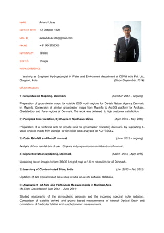
1. NAME Anand Utsav
DATE OF BIRTH 12 October 1990
MAIL ID anandutsav.iitb@gmail.com
PHONE +91 9643753306
NATIONALITY Indian
STATUS Single
WORK EXPEREINCE
Working as Engineer/ Hydrogeologist in Water and Environment department at COWI India Pvt. Ltd,
Gurgaon, India (Since September, 2014)
MAJOR PROJECTS
1) Groundwater Mapping, Denmark (October 2014 – ongoing)
Preparation of groundwater maps for outside OSD north regions for Danish Nature Agency Denmark
in Mapinfo. Conversion of similar groundwater maps from Mapinfo to ArcGIS platform for Andkær,
Gredstedbro and Fanø regions of Denmark. The work was delivered to high customer satisfaction.
2) Pumptest Interpretation, Sydhavnen/ Nordhavn Metro (April 2015 – May 2015)
Preparation of a technical note to provide input to groundwater modelling decisions by supporting T-
value choices made from average or non-local data analysed on AQTESOLV.
3) Qatar Rainfall and Runoff manual (June 2015 – ongoing)
Analysis of Qatar rainfall data of over 100 years and preparation on rainfall and runoffmanual.
4) Digital Elevation Modelling, Denmark (March 2015 - April 2015)
Mosaicing raster images to form 30x30 km grid map at 1.6 m resolution for all Denmark.
5) Inventory of Contaminated Sites, India (Jan 2015 – Feb 2015)
Updation of 320 contaminated lake sites in India on a GIS software database.
6) Assessment of AOD and Particulate Measurements in Mumbai Area
(M.Tech. Dissertation) (Jan 2013 – June 2014)
Studied relationship of the atmospheric aerosols and the incoming spectral solar radiation.
Comparison of satellite derived and ground based measurements of Aerosol Optical Depth and
correlations of Particular Matter and sunphotometer measurements.
2. MINOR/ACADEMIC PROJECTS
7) Solid Waste Management Plan for Patna City (Acadamic Term Paper) (July 2012 – Nov 2012)
Development of a solid waste management plan by suggesting the number and type of bins used for
collection and transport of 700 metric tons of solid waste in an urban city of Patna, India.
8) Water network modelling using EPANET (Academic Term Paper) (Jan 2013 – April 2013)
Surveying of the water demand of the entire IIT Mumbai campus and assigning nodes to calculate the
flow pressure using EPANET software.
9) EIA of Mumbai Metro (Academic Term Paper) (Jan 2013 – April 2013)
Assessing and quantifying the environment and social impact of the Mumbai Metro.
10) Validation of the results of Sanitation Drive in Orrisa (July 2011)
Participated as a field investigator in a Unites Nations University (UNU_MERIT) research project to
travel across rural Odisha and survey the condition and financing of the rural toilets build as per
microfinance model of local NGOs.
EDUCATIONAL QUALIFICATION
M.Tech., Indian Institute of Technology Bombay, India, 07/2012-06/2014; Environmental Engineering
B.Tech., West Bengal University of Technology, India, 07/2008-06/2012; Civil Engineering
TRAINING
1) Mapinfo, ArcGIS, Advanced MS Excel training from COWI, Lyngby, Denmark
2) Course on Air quality assessment by satellite and ground based Remote sensing, NASA
3) Industrial training at NTPC, Kahalgaon
4) Short course on Occupational Exposure and Industrial Health and Safety, IIT Bombay
5) International Summer School on Sustainability, TERI University.
6) Workshop on Earthquake resistant design of Structures, Tata Steel.
7) Entrepreneurship awereness Camp, Tata chemical Society for Rural Development.
SOFTWARE SKILLS
EXPERT PROFICIENT BASIC
ARCGIS
MAPINFO
MS EXCEL
MATLAB
AERMOD
EPANET
C
3. POSITION OF RESPONSIBILITY
1) Quality Champion, COWI India (Since July 2015)
Responsible for maintaining quality of delivarables at Water and Environment department at COWI,
by seeing that all quality forms are placed in their respective locations on the project folder.
2) Group Coordinator, Energy Technologies Vision 2035 (July 2012)
Coordinated to prepare a report on the social and environmental aspect of the Energy Vision 2035,
Department of Science and Technology, Government of India.
3) Campus Ambassador, Rio+21 IYWC India (July 2013)
Served as a Water leader by organising a certification program by Indian Astrobiology Research
Centre, Mumbai and listed by UN conference on Sustainable Development and Government of India.
LANGUAGE SKILLS
SPEAKING READING WRITING
Excellent Excellent Excellent
Mother tongue Mother tongue Mother tongue
AREAS OF INTEREST
Environment Impact Assessment
Air quality and water quality monitoring
Pump test analysis and associated hydrogeology
EMPLOYMENT RECORD
09/2014 – Present COWI India Pvt. Ltd.
PROFESSIONAL REFERENCES
1. Tapesh Ajmera
Hydrogeologist Specialist, Water and Environment, COWI India Pvt. Ltd
(tkaj@cowi.in)
2. Silvio Pereira
Engineer, Consultant, Coordinator, Water and Geosciences, COWI Denmark
(sipa@cowi.dk)