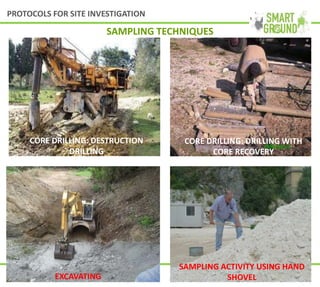
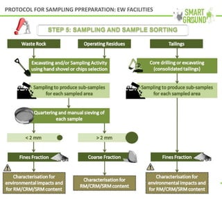
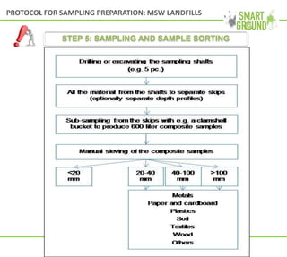
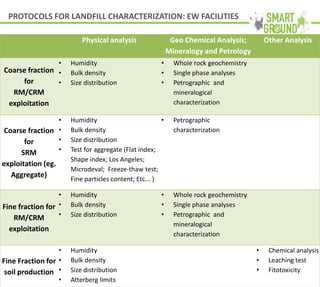
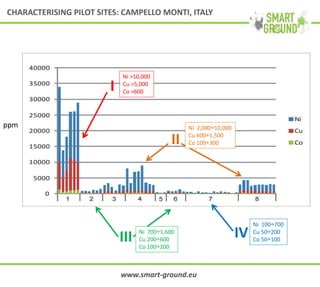
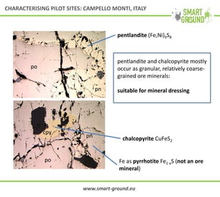
This document summarizes the SMART GROUND project which aims to enhance availability and accessibility of data on secondary raw materials in the EU. It outlines the project's approach to characterizing extractive waste facilities, municipal solid waste landfills, and other sites to identify secondary raw materials and critical raw materials. The characterization involves preliminary research, geophysical and drone surveys, sampling schemes, sample analysis, and pilot site characterization activities. The goal is to understand the waste deposits and identify materials that could be exploited for secondary raw materials or recycled.
This document provides an overview of various remote sensing and GIS-based techniques used for mineral exploration applications in Africa. It discusses 10 techniques: 1) image processing of satellite data, 2) filtering geophysical data, 3) surface modeling, 4) spatial selection rules and proximity analyses, 5) determining anomalous assay data, 6) estimating resource volumes, 7) resource modeling and drillhole planning, 8) data visualization through fly-throughs, 9) regional context analysis, and 10) considering geological history. Examples are given for each technique to demonstrate how they can be applied to improve mineral exploration efforts. The document emphasizes how data visualization and spatial analysis tools can provide insight into geological datasets.
This document summarizes ArcelorMittal Tubarão's experience using BOF slag as ballast for railways. It describes how over 1 million tons of slag was used successfully for many years until problems arose in 2006 due to slag fines and electrical conductivity issues. Studies identified high calcium content and expansion as causes. A curing method was developed using different storage configurations and weathering cycles to reduce calcium levels and prepare the slag for use as ballast. Initial results showed success in reducing calcium content to appropriate levels for rail ballast use.
This document summarizes the characterization of municipal solid waste (MSW) and extractive waste sites for the recovery of secondary raw materials (SRMs) as part of the SMART-GROUND project. The project aims to enhance availability and accessibility of data on SRMs in the EU. The document outlines an 8-step protocol for characterizing landfills and waste sites, including collecting preliminary information, investigating deposits, developing sampling schemes, collecting and sorting samples, characterizing samples, feeding data to the SMART-GROUND database, outlining schemes for SRM recovery, and evaluating sustainability using a decision support tool.
This document discusses screening methods for identifying potential sites for enhanced landfill mining. It describes various geophysical methods like electrical resistivity, magnetics, and electromagnetic surveys that can characterize waste layers and materials. A case study applying these methods at a tailings pond in Finland is presented, identifying areas with higher nickel and sulfide content. The document also discusses using drone photogrammetry and laser scanning to create high-resolution 3D models of landfill sites to aid in screening and modeling.
The ADEMA project comprised research to enhance mining exploration and planning capability through studies of seismic processing, radio imaging, drilling parameter analysis, micro-seismic activity and predictive analysis. Key accomplishments included:
1) Developing acoustic impedance inversion techniques to classify rock strata from seismic data.
2) Designing a 64-channel micro-seismic system to automatically record tremors and generate velocity images to assess seismic hazard zones.
3) Adapting oil industry techniques such as 3D seismic data reprocessing, inversion and lithology classification for coal environments.
4) Analyzing drilling parameters to correlate specific energy and drilling exponent with rock mechanical properties.
5) Completing an extensive appraisal of
The file discuss many topics of well logging
01 Introduction
02 Drilling fluid invasion
03 Resistivity & ARCHIE Equations
04 SP
05 resistivity log
06 gamma ray log
07 sonic log
08 density log
09 neutron log
10 litho density
11 tdt
12 plt
Abnormal pressure Zones
caliper log
Notes on shale and clay mineral
The CNR (National Research Council of Italy) supports Italy's space sector in several areas:
- Earth observation for studying natural phenomena and risks using satellites and new platforms like stratospheric balloons and nanosatellites.
- Developing new observational payloads and data management systems.
- Launching small satellites from an airborne "AirLaunch" platform.
- Materials, communications, and technologies for energy storage and efficiency with applications for aerospace.
The CNR collaborates closely with the government and industry to provide scientific and technological support and strengthen Italy's role in space.
Geophysical survey for the risk managementMario Naldi
This document discusses managing risk through geophysical survey methods for due diligence assessments. It describes how non-invasive geophysical surveys such as electromagnetic, ground penetrating radar, and electrical resistivity tomography can identify subsurface hazards cost effectively by mapping buried utilities, tanks, waste, and other underground anomalies before invasive investigations. Large scale surveys identify potential risks while small scale surveys characterize identified anomalies to better inform follow up actions.
This document summarizes decision support tools developed for enhanced landfill mining of municipal solid waste and extractive waste. The tools provide scenarios for remediation and material recovery from landfills. For municipal solid waste, scenarios consider different waste compositions and technologies for soil flushing, excavation, separation and processing. Economic, environmental and social impacts are evaluated. The best scenario is selected based on predefined criteria like highest net income. Similarly for extractive waste, scenarios apply various technologies and assess revenues, costs and net income to identify the optimal option. The tools aim to enhance availability of secondary raw materials from landfills.
The use of geoinformatics in mineral exploration and exploitationMarguerite Walsh
The document discusses the use of geoinformatics, including remote sensing techniques, in mineral exploration and exploitation. It provides several case studies demonstrating how different remote sensing data and techniques can be used to map surface geology and identify potential mineral deposits. These include using Landsat and ASTER satellite imagery to map surficial mineralogy across large areas, detect hydrothermal alteration zones indicating gold mineralization, and identify geothermal anomalies. Integrating remote sensing data with other spatial datasets in a GIS provides additional insights. Future opportunities discussed include the increasing use of unmanned aerial vehicles and the upcoming Sentinel-2 satellite mission.
Umwelt- und Ingenieurtechnik GmbH Dresden provides mineral resource and environmental services including mineral resource estimation, feasibility studies, metallurgical studies, geophysical logging, hydrological and reactive transport modeling, mining and industrial water management, and environmental monitoring. The company has specific experience in rare earth elements, uranium, and in-situ leaching projects. Services are tailored to the client's technical requirements, budget, and timeline.
Karu application of_modelling_tools_in_estonian_oil_shale_mining_areaMäeinstituut Ttü
This document summarizes research on applying modelling tools to oil shale mining in Estonia. Key points:
1) Computer modelling is used to study the environmental impacts of large-scale mining tests, as such tests are complicated to perform directly in nature. Modelling allows evaluation of different mining technologies and development plans.
2) The research aims to develop criteria and demonstration methods for sustainable mining through modelling. Case studies apply various modelling software to tasks like visualizing mine plans, assessing underground impacts, and planning infrastructure like sewage systems near mines.
3) The results of the modelling research are intended to help institutions with planning and decision-making regarding mineral resource extraction and land use in a way that considers economic,
The International Journal of Engineering & Science is aimed at providing a platform for researchers, engineers, scientists, or educators to publish their original research results, to exchange new ideas, to disseminate information in innovative designs, engineering experiences and technological skills. It is also the Journal's objective to promote engineering and technology education. All papers submitted to the Journal will be blind peer-reviewed. Only original articles will be published.
Preparation of a Desktop Survey and Design Report for the installation of approximately 1808km of fibre optic cable. This route comprises of coastal and inland portions along the N2 from Umhlanga to Cape Town
ASSESSING THE USE OF UNMANNED AERIAL VEHICLES (UAV)/DRONES IN MINING INDUSTRYIRJET Journal
This document discusses using unmanned aerial vehicles (UAVs/drones) in mining applications. It conducted a case study comparing UAV surveying to conventional surveying methods in a soapstone mine. The key findings were:
1) UAV surveying was faster, taking half the time, and more cost-effective compared to conventional surveying for the given area size.
2) UAV surveying required half the manpower of conventional methods.
3) The data obtained from UAV surveying, such as area calculations and slope analyses, were just as accurate as conventional methods.
The document discusses 3D geological modelling of soils in Finland to support sustainable land use decisions. It summarizes that traditional geological modelling does not work for Finland due to a lack of borehole logs, and instead numerical modelling must be used to interpret in-situ test data and correlate it with stratigraphic profiles. The document also presents a case study where 3D modelling was used to classify clay basins in the Helsinki area to identify challenging areas for construction, and to define lake water infiltration rates into an esker aquifer.
The document discusses applications of multi-scale spectral sensing techniques for mineral and hydrocarbon exploration and production. It provides examples of using field and laboratory-based spectrometers and hyperspectral imaging to map minerals in drill cores and mine faces. Specific cases examine iron, gold, and rare earth element deposits. Spectroscopic data is used to identify mineral distributions and compositions for ore control and process optimization.
The significance of Surface Logging For The Formation Evaluation Advance Surf...Evangelos Siskos
The significance of Surface Logging For The Formation Evaluation Advance Surface Logging Technology is a Master of Science Thesis presentation for the MSc in Oil & Gas Technology program at Eastern Macedonia and thrace Institute of Technology.
STAGR technology uses structural-thermo-atmo-hydro-geochemical research to identify priority areas and sweet spots for hydrocarbon deposits. It analyzes geological, geophysical, and satellite image data to map potential fractured zones and sample locations. Fieldwork samples air and ground gases, while laboratory analysis identifies concentrations of gases like radon, helium, and hydrocarbons. Thermometric studies correlate local temperature anomalies to identify deposits. Integrating these data produces aggregated maps of promising hydrocarbon areas. The low-cost, non-intrusive method has been applied to 80 geological sites, leading to 14 productive wells drilled offshore and onshore in Ukraine and Russia.
07 vicente guna fa 0073-feasibility of pvp_ps in spain-20110913_ed01pvsinbloom
This document summarizes a study on the feasibility of installing photovoltaic power plants (PVPPs) in marginal lands in Spain. The study identified criteria for classifying land as marginal, used GIS to map potentially suitable areas, and conducted an economic analysis of a pilot PVPP project compared to environmental restoration costs. Key findings included the potential for over 16GW of solar power from marginal lands and that PVPP investments had a more favorable cost-benefit ratio than restoration in the pilot case. The conclusions were that PVPPs in marginal areas could have positive socioeconomic and environmental impacts in Spain.
This document contains the resume of Naceruddine Benabdallah, an engineer in geology and sedimentologist from Algeria. He received a degree in geology in 2004 with a focus on sedimentology. His professional experience includes various roles in logging and as a geologist for oil companies in Algeria from 2006 to the present. He has technical expertise in areas like well monitoring, log interpretation, and reservoir modeling. He is proficient in English, French, and Arabic and has skills in computer programs for geological analysis.
The document outlines the motivation, principles, technical features, field examples, and modeling capabilities of MobileMT, a next generation airborne audio-frequency magnetotelluric (AFMAG) system. MobileMT collects broadband electromagnetic data from 34 Hz to 21,619 Hz using independent magnetic and electric channels, allowing for high-resolution 3D inversion of resistivity structures. Field examples from Canada and Australia demonstrate MobileMT's ability to map geological units like alteration zones and basement boundaries to depths over 2.5 km in resistive environments. 1D, 2D, and 3D inversions of MobileMT data provide detailed images of subsurface resistivity contrasts useful for mineral exploration targeting.
Application of UNFC in Cameroon: lessons learned, experiences and proposals for harmonization and development of an AMREC
CristelIe Nikoh Mefuegend, Dept. of Petroleum Products and Gas, Ministry of Water and Energy (MINES), Cameroon
This document provides information on SUDMINE SAS, a French mining company established in 2013 that operates 3 exploration licenses covering 122 km2 in French Guiana. SUDMINE's goal is to develop fairmined coltan projects in French Guiana as an alternative to conflict minerals from Africa. The document discusses coltan mineralogy, applications, trade issues, and the potential for developing small, rich coltan deposits from the exploration licenses, which cover known coltan placers in French Guiana previously explored in the 1950s-1960s.
The document discusses mining waste reduction methods through several pilot projects in different countries in the Baltic Sea Region. The Estonian project involves a mobile unit for processing mining waste like oil shale waste rock into construction aggregates. The Swedish project aims to recover valuable and hazardous metals from mining and metal processing waste through a leaching and extraction process. The Finnish project involves a mobile module for testing the recycling of mining waste by grinding and classifying the material for potential use as an adsorbent. The Polish project develops artificial aggregates from mining waste for construction use through an agglomeration process. The overall goal is to promote sustainable waste management and resource efficiency in the mining industry through knowledge sharing between countries in the region.
The document discusses mining waste reduction methods through several pilot projects in different Baltic Sea Region countries. The Estonian project involves a mobile unit for processing mining waste into construction aggregates. The Swedish project develops a process for extracting valuable and hazardous metals from mining and metal waste. The Finnish project tests recycling mine waste by constructing a mobile module to grind and classify materials for potential use in wastewater purification. The Polish project produces artificial aggregate from mineral processing waste for construction using an agglomeration process. Overall the projects aim to promote sustainable waste management and resource recovery in the mining industry through knowledge sharing and demonstration of technologies across the Baltic Sea Region.
The document discusses the COCOON project which aims to improve regional policies related to landfill management. COCOON involves partners from several European regions and has two phases: an interregional learning phase from 2017-2019 and a monitoring phase of regional action plans from 2020-2021. The objectives are to develop, integrate and improve relevant regional policy instruments regarding landfill management. Activities include exchanging experiences, developing regional action plans, and involving stakeholders. The document also discusses related EU policies and landfill mining initiatives.
This document provides an overview of the RAWFILL project, which aims to support the recovery of raw materials from landfills in North-West Europe. The RAWFILL project develops an enhanced landfill inventory framework (ELIF), an innovative landfill characterization method using geophysical imaging and guided sampling, and a decision support tool (DST) to help prioritize profitable landfill mining projects. The document discusses the challenges of evaluating landfill mining potential and profitability, and outlines RAWFILL's approach to addressing these challenges through the creation of standardized tools and methods.
More Related Content
Similar to 3 SMART GROUND - COCOON - RAWFILL Workshop
Geophysical survey for the risk managementMario Naldi
This document discusses managing risk through geophysical survey methods for due diligence assessments. It describes how non-invasive geophysical surveys such as electromagnetic, ground penetrating radar, and electrical resistivity tomography can identify subsurface hazards cost effectively by mapping buried utilities, tanks, waste, and other underground anomalies before invasive investigations. Large scale surveys identify potential risks while small scale surveys characterize identified anomalies to better inform follow up actions.
This document summarizes decision support tools developed for enhanced landfill mining of municipal solid waste and extractive waste. The tools provide scenarios for remediation and material recovery from landfills. For municipal solid waste, scenarios consider different waste compositions and technologies for soil flushing, excavation, separation and processing. Economic, environmental and social impacts are evaluated. The best scenario is selected based on predefined criteria like highest net income. Similarly for extractive waste, scenarios apply various technologies and assess revenues, costs and net income to identify the optimal option. The tools aim to enhance availability of secondary raw materials from landfills.
The use of geoinformatics in mineral exploration and exploitationMarguerite Walsh
The document discusses the use of geoinformatics, including remote sensing techniques, in mineral exploration and exploitation. It provides several case studies demonstrating how different remote sensing data and techniques can be used to map surface geology and identify potential mineral deposits. These include using Landsat and ASTER satellite imagery to map surficial mineralogy across large areas, detect hydrothermal alteration zones indicating gold mineralization, and identify geothermal anomalies. Integrating remote sensing data with other spatial datasets in a GIS provides additional insights. Future opportunities discussed include the increasing use of unmanned aerial vehicles and the upcoming Sentinel-2 satellite mission.
Umwelt- und Ingenieurtechnik GmbH Dresden provides mineral resource and environmental services including mineral resource estimation, feasibility studies, metallurgical studies, geophysical logging, hydrological and reactive transport modeling, mining and industrial water management, and environmental monitoring. The company has specific experience in rare earth elements, uranium, and in-situ leaching projects. Services are tailored to the client's technical requirements, budget, and timeline.
Karu application of_modelling_tools_in_estonian_oil_shale_mining_areaMäeinstituut Ttü
This document summarizes research on applying modelling tools to oil shale mining in Estonia. Key points:
1) Computer modelling is used to study the environmental impacts of large-scale mining tests, as such tests are complicated to perform directly in nature. Modelling allows evaluation of different mining technologies and development plans.
2) The research aims to develop criteria and demonstration methods for sustainable mining through modelling. Case studies apply various modelling software to tasks like visualizing mine plans, assessing underground impacts, and planning infrastructure like sewage systems near mines.
3) The results of the modelling research are intended to help institutions with planning and decision-making regarding mineral resource extraction and land use in a way that considers economic,
The International Journal of Engineering & Science is aimed at providing a platform for researchers, engineers, scientists, or educators to publish their original research results, to exchange new ideas, to disseminate information in innovative designs, engineering experiences and technological skills. It is also the Journal's objective to promote engineering and technology education. All papers submitted to the Journal will be blind peer-reviewed. Only original articles will be published.
Preparation of a Desktop Survey and Design Report for the installation of approximately 1808km of fibre optic cable. This route comprises of coastal and inland portions along the N2 from Umhlanga to Cape Town
ASSESSING THE USE OF UNMANNED AERIAL VEHICLES (UAV)/DRONES IN MINING INDUSTRYIRJET Journal
This document discusses using unmanned aerial vehicles (UAVs/drones) in mining applications. It conducted a case study comparing UAV surveying to conventional surveying methods in a soapstone mine. The key findings were:
1) UAV surveying was faster, taking half the time, and more cost-effective compared to conventional surveying for the given area size.
2) UAV surveying required half the manpower of conventional methods.
3) The data obtained from UAV surveying, such as area calculations and slope analyses, were just as accurate as conventional methods.
The document discusses 3D geological modelling of soils in Finland to support sustainable land use decisions. It summarizes that traditional geological modelling does not work for Finland due to a lack of borehole logs, and instead numerical modelling must be used to interpret in-situ test data and correlate it with stratigraphic profiles. The document also presents a case study where 3D modelling was used to classify clay basins in the Helsinki area to identify challenging areas for construction, and to define lake water infiltration rates into an esker aquifer.
The document discusses applications of multi-scale spectral sensing techniques for mineral and hydrocarbon exploration and production. It provides examples of using field and laboratory-based spectrometers and hyperspectral imaging to map minerals in drill cores and mine faces. Specific cases examine iron, gold, and rare earth element deposits. Spectroscopic data is used to identify mineral distributions and compositions for ore control and process optimization.
The significance of Surface Logging For The Formation Evaluation Advance Surf...Evangelos Siskos
The significance of Surface Logging For The Formation Evaluation Advance Surface Logging Technology is a Master of Science Thesis presentation for the MSc in Oil & Gas Technology program at Eastern Macedonia and thrace Institute of Technology.
STAGR technology uses structural-thermo-atmo-hydro-geochemical research to identify priority areas and sweet spots for hydrocarbon deposits. It analyzes geological, geophysical, and satellite image data to map potential fractured zones and sample locations. Fieldwork samples air and ground gases, while laboratory analysis identifies concentrations of gases like radon, helium, and hydrocarbons. Thermometric studies correlate local temperature anomalies to identify deposits. Integrating these data produces aggregated maps of promising hydrocarbon areas. The low-cost, non-intrusive method has been applied to 80 geological sites, leading to 14 productive wells drilled offshore and onshore in Ukraine and Russia.
07 vicente guna fa 0073-feasibility of pvp_ps in spain-20110913_ed01pvsinbloom
This document summarizes a study on the feasibility of installing photovoltaic power plants (PVPPs) in marginal lands in Spain. The study identified criteria for classifying land as marginal, used GIS to map potentially suitable areas, and conducted an economic analysis of a pilot PVPP project compared to environmental restoration costs. Key findings included the potential for over 16GW of solar power from marginal lands and that PVPP investments had a more favorable cost-benefit ratio than restoration in the pilot case. The conclusions were that PVPPs in marginal areas could have positive socioeconomic and environmental impacts in Spain.
This document contains the resume of Naceruddine Benabdallah, an engineer in geology and sedimentologist from Algeria. He received a degree in geology in 2004 with a focus on sedimentology. His professional experience includes various roles in logging and as a geologist for oil companies in Algeria from 2006 to the present. He has technical expertise in areas like well monitoring, log interpretation, and reservoir modeling. He is proficient in English, French, and Arabic and has skills in computer programs for geological analysis.
The document outlines the motivation, principles, technical features, field examples, and modeling capabilities of MobileMT, a next generation airborne audio-frequency magnetotelluric (AFMAG) system. MobileMT collects broadband electromagnetic data from 34 Hz to 21,619 Hz using independent magnetic and electric channels, allowing for high-resolution 3D inversion of resistivity structures. Field examples from Canada and Australia demonstrate MobileMT's ability to map geological units like alteration zones and basement boundaries to depths over 2.5 km in resistive environments. 1D, 2D, and 3D inversions of MobileMT data provide detailed images of subsurface resistivity contrasts useful for mineral exploration targeting.
Application of UNFC in Cameroon: lessons learned, experiences and proposals for harmonization and development of an AMREC
CristelIe Nikoh Mefuegend, Dept. of Petroleum Products and Gas, Ministry of Water and Energy (MINES), Cameroon
This document provides information on SUDMINE SAS, a French mining company established in 2013 that operates 3 exploration licenses covering 122 km2 in French Guiana. SUDMINE's goal is to develop fairmined coltan projects in French Guiana as an alternative to conflict minerals from Africa. The document discusses coltan mineralogy, applications, trade issues, and the potential for developing small, rich coltan deposits from the exploration licenses, which cover known coltan placers in French Guiana previously explored in the 1950s-1960s.
The document discusses mining waste reduction methods through several pilot projects in different countries in the Baltic Sea Region. The Estonian project involves a mobile unit for processing mining waste like oil shale waste rock into construction aggregates. The Swedish project aims to recover valuable and hazardous metals from mining and metal processing waste through a leaching and extraction process. The Finnish project involves a mobile module for testing the recycling of mining waste by grinding and classifying the material for potential use as an adsorbent. The Polish project develops artificial aggregates from mining waste for construction use through an agglomeration process. The overall goal is to promote sustainable waste management and resource efficiency in the mining industry through knowledge sharing between countries in the region.
The document discusses mining waste reduction methods through several pilot projects in different Baltic Sea Region countries. The Estonian project involves a mobile unit for processing mining waste into construction aggregates. The Swedish project develops a process for extracting valuable and hazardous metals from mining and metal waste. The Finnish project tests recycling mine waste by constructing a mobile module to grind and classify materials for potential use in wastewater purification. The Polish project produces artificial aggregate from mineral processing waste for construction using an agglomeration process. Overall the projects aim to promote sustainable waste management and resource recovery in the mining industry through knowledge sharing and demonstration of technologies across the Baltic Sea Region.
Similar to 3 SMART GROUND - COCOON - RAWFILL Workshop (20)
The document discusses the COCOON project which aims to improve regional policies related to landfill management. COCOON involves partners from several European regions and has two phases: an interregional learning phase from 2017-2019 and a monitoring phase of regional action plans from 2020-2021. The objectives are to develop, integrate and improve relevant regional policy instruments regarding landfill management. Activities include exchanging experiences, developing regional action plans, and involving stakeholders. The document also discusses related EU policies and landfill mining initiatives.
This document provides an overview of the RAWFILL project, which aims to support the recovery of raw materials from landfills in North-West Europe. The RAWFILL project develops an enhanced landfill inventory framework (ELIF), an innovative landfill characterization method using geophysical imaging and guided sampling, and a decision support tool (DST) to help prioritize profitable landfill mining projects. The document discusses the challenges of evaluating landfill mining potential and profitability, and outlines RAWFILL's approach to addressing these challenges through the creation of standardized tools and methods.
The SMART GROUND platform was developed to enable collaboration around secondary raw materials from waste sites. It provides a repository for datasets on waste sites, materials, and a web portal for publishing, searching, and analyzing this information. Key features include semantically enriched search tags, a crowd-sourcing approach, spatial mapping capabilities, and downloadable data. The platform integrates data from mining sites, landfills, and treatment plants using a standardized data model. It is currently in open testing phase and future work will focus on engaging more users and data sources to create a sustainable marketplace for secondary raw materials.
This project summary outlines the objectives and activities of the SMART GROUND project, which aims to enhance availability and accessibility of data on secondary raw materials in the EU. The project has 14 partners from 5 EU countries and received full funding from the Horizon 2020 program. Key objectives include collecting and integrating quantitative and structural knowledge on secondary raw materials from existing landfills, identifying promising markets, and building an inventory database. To achieve these objectives, the project will characterize pilot sites, estimate materials potential, and create an open user-friendly online platform to facilitate sharing of reports, statistics, and advanced search/retrieval of data.
This document summarizes a workshop held on February 7th, 2018 in Mechelen, Belgium to discuss progress on several European landfill mining projects. The workshop aimed to provide key outputs from the SMART GROUND project, updates on the COCOON and RAWFILL projects, and discuss next steps. It included presentations on the approaches and pilot studies from SMART GROUND, an overview of the SMART GROUND databank and decision support tools, and progress reports from the RAWFILL and COCOON projects. The goal was to maintain momentum on the ELFM concept and its integration within the circular economy for applications such as waste-to-energy, waste-to-materials, and land restoration.
The SMART GROUND project aims to enhance the availability and accessibility of data on secondary raw materials in the EU by creating an integrated data collection and sharing platform. The platform will combine existing secondary raw materials data with new data collected from pilot landfill characterization projects. It will include a marketplace for secondary raw materials information and business opportunities, a networking platform to connect stakeholders, a geospatial portal, open source software and tools developed by the project, and knowledge transfer services. The overall goal is to improve resource efficiency and support the transition to a circular economy in the EU.
This document describes two toolkits created by the SMART project to help stakeholders evaluate the feasibility of enhanced landfill mining (ELFM) projects. The Enhanced Landfill Mining Toolkits provide necessary information for those interested in conducting an ELFM project, while the Decision Support Tool allows users to conduct an economic, environmental, and social assessment of a proposed ELFM project under different scenarios. Both toolkits are available on the SMART website.
The SMART GROUND project aims to enhance availability and accessibility of data on secondary raw materials from landfill mining in the EU. Funded by the European Commission's Horizon 2020 program, the 30-month project involves 14 partners from 5 EU countries. The objectives are to collect and integrate quantitative and structural data on secondary raw materials, identify promising markets, evaluate environmental and socioeconomic impacts, analyze legislation, and build an inventory through a database platform. The project focuses on construction and demolition waste, municipal waste, and mining waste from landfills.
The newsletter provides an overview of the SMART GROUND project, which aims to foster resource recovery from landfills in the EU by improving data availability on secondary raw materials. It introduces the consortium members and lists events attended to promote the project. Upcoming events are announced, and synergies with other EU waste projects are described. The newsletter encourages readers to learn more by visiting the project website or downloading promotional materials.
El documento describe el proyecto SMART GROUND, cuyo objetivo es desarrollar una plataforma para recopilar y integrar datos sobre materias primas secundarias en Europa con el fin de mejorar su disponibilidad y accesibilidad. El proyecto busca caracterizar las existencias de materias primas secundarias, armonizar estándares e inventarios, e integrar los datos en una base de datos única de la UE para identificar mercados y evaluar impactos ambientales, económicos y sociales. La plataforma ayudará a mejorar la economía
The SMART GROUND project aims to enhance availability and accessibility of data on secondary raw materials in the EU by creating an integrated database. It will develop protocols for landfill data collection and characterization, perform cost-benefit analyses and life cycle assessments. The project will also provide workshops, conferences, and training materials on best practices.
This project summary provides information on the SMART GROUND project:
1) The SMART GROUND project received €2.496.800,10 in funding from the Horizon 2020 research and innovation programme under Grant Agreement No 641988 to last from October 1, 2015 to March 31, 2018.
2) The project aims to foster resource recovery from landfills by improving data availability and accessibility on secondary raw materials in the European Union. It will integrate existing and new data into a single EU database.
3) Additionally, the project seeks to enhance the economic and employment potential of secondary raw materials by providing training and forming a network of stakeholders committed to research and technology transfer.
The document outlines the goals of the SMARTGROUND project which include obtaining quantitative and structural data from secondary raw material resources through landfill modeling and characterization. It aims to create a data bank repository with an analysis framework to enhance availability and accessibility of secondary raw material data in the EU. The project also seeks to identify sustainability issues for waste streams, conduct socioeconomic analyses, transfer knowledge through networking, and disseminate findings to stakeholders.
This document summarizes a networking session that discussed concepts related to circular economy and landfill mining. Specifically, it discussed key concepts for exploiting waste as new resources. The session was led by professors and doctors from the University of Turin who presented data on soil contamination near waste heaps from metal mines. Samples found elevated levels of metals like lead, cadmium, copper, and zinc in the soil. Under anoxic conditions, these metals became more soluble and their transfer to other environments was favored. The conclusion was that mine waste poses an environmental risk due to the availability of metals in the soil and this risk increases under low-oxygen conditions.
Minerali Industriali is an Italian mining company that operates mines, processing plants, and marketing facilities for raw materials. It has 29 locations worldwide and produces about 3 million tons of materials per year. The company focuses on research and development to improve extraction and processing methods. It also aims to reduce waste and practice circular economy principles by recovering materials from waste streams for reuse. One example is a project that recovers and processes glass waste for use in the glass and construction industries. The company continuously works to find new applications for lower quality and waste materials to further reduce waste and costs.
This document summarizes a presentation on enhanced landfill mining and circular economy concepts. It discusses landfill mining situations across Europe and provides a UK case study. Enhanced landfill mining aims to extract both materials and energy from historic and future landfill waste using innovative technologies. It can provide benefits like avoiding landfill remediation costs, creating a new resource recovery economy, and recovering valuable land. The presentation provides details on a UK landfill assessment that found over half were suitable for mining. A life cycle assessment and cost benefit analysis were also conducted. A case study on rare earth element recovery from landfill soils found potential values from platinum group metals, rare earths, aluminum and copper. Excavated materials could also
The document discusses the concepts of circular economy and landfill mining to exploit waste as new resources. It proposes using a combination of cost-benefit analysis and life cycle assessment to evaluate pilot technology chains for extracting raw materials from landfills. The methodology would calculate private business returns, environmental impacts, and external costs and benefits to determine the optimal solution for society. The results could then be used to inform alternatives for implementing landfill mining based on whether private investment yields a profit, provides a public benefit, or imposes external costs.
Ernő Garamvölgyi
Bay Zoltán Nonprofit Ltd.
garamvolgyi.erno@bayzoltan.hu
Project Partners:
- ENCO s.r.l. (IT)
- Bay Zoltán Nonprofit Ltd. (HU)
- University of Patras (GR)
- University of Ljubljana (SI)
- University of Aveiro (PT)
- University of Birmingham (UK)
- Geological Survey of Slovenia (SI)
- Geological Survey of Finland (FI)
- Geological Survey of Norway (NO)
- Geological Survey of Ireland (IE)
- Geological Survey of Italy (IT)
Epcon is One of the World's leading Manufacturing Companies.EpconLP
Epcon is One of the World's leading Manufacturing Companies. With over 4000 installations worldwide, EPCON has been pioneering new techniques since 1977 that have become industry standards now. Founded in 1977, Epcon has grown from a one-man operation to a global leader in developing and manufacturing innovative air pollution control technology and industrial heating equipment.
Evolving Lifecycles with High Resolution Site Characterization (HRSC) and 3-D...Joshua Orris
The incorporation of a 3DCSM and completion of HRSC provided a tool for enhanced, data-driven, decisions to support a change in remediation closure strategies. Currently, an approved pilot study has been obtained to shut-down the remediation systems (ISCO, P&T) and conduct a hydraulic study under non-pumping conditions. A separate micro-biological bench scale treatability study was competed that yielded positive results for an emerging innovative technology. As a result, a field pilot study has commenced with results expected in nine-twelve months. With the results of the hydraulic study, field pilot studies and an updated risk assessment leading site monitoring optimization cost lifecycle savings upwards of $15MM towards an alternatively evolved best available technology remediation closure strategy.
Optimizing Post Remediation Groundwater Performance with Enhanced Microbiolog...Joshua Orris
Results of geophysics and pneumatic injection pilot tests during 2003 – 2007 yielded significant positive results for injection delivery design and contaminant mass treatment, resulting in permanent shut-down of an existing groundwater Pump & Treat system.
Accessible source areas were subsequently removed (2011) by soil excavation and treated with the placement of Emulsified Vegetable Oil EVO and zero-valent iron ZVI to accelerate treatment of impacted groundwater in overburden and weathered fractured bedrock. Post pilot test and post remediation groundwater monitoring has included analyses of CVOCs, organic fatty acids, dissolved gases and QuantArray® -Chlor to quantify key microorganisms (e.g., Dehalococcoides, Dehalobacter, etc.) and functional genes (e.g., vinyl chloride reductase, methane monooxygenase, etc.) to assess potential for reductive dechlorination and aerobic cometabolism of CVOCs.
In 2022, the first commercial application of MetaArray™ was performed at the site. MetaArray™ utilizes statistical analysis, such as principal component analysis and multivariate analysis to provide evidence that reductive dechlorination is active or even that it is slowing. This creates actionable data allowing users to save money by making important site management decisions earlier.
The results of the MetaArray™ analysis’ support vector machine (SVM) identified groundwater monitoring wells with a 80% confidence that were characterized as either Limited for Reductive Decholorination or had a High Reductive Reduction Dechlorination potential. The results of MetaArray™ will be used to further optimize the site’s post remediation monitoring program for monitored natural attenuation.
Presented by The Global Peatlands Assessment: Mapping, Policy, and Action at GLF Peatlands 2024 - The Global Peatlands Assessment: Mapping, Policy, and Action
Climate Change All over the World .pptxsairaanwer024
Climate change refers to significant and lasting changes in the average weather patterns over periods ranging from decades to millions of years. It encompasses both global warming driven by human emissions of greenhouse gases and the resulting large-scale shifts in weather patterns. While climate change is a natural phenomenon, human activities, particularly since the Industrial Revolution, have accelerated its pace and intensity
Kinetic studies on malachite green dye adsorption from aqueous solutions by A...Open Access Research Paper
Water polluted by dyestuffs compounds is a global threat to health and the environment; accordingly, we prepared a green novel sorbent chemical and Physical system from an algae, chitosan and chitosan nanoparticle and impregnated with algae with chitosan nanocomposite for the sorption of Malachite green dye from water. The algae with chitosan nanocomposite by a simple method and used as a recyclable and effective adsorbent for the removal of malachite green dye from aqueous solutions. Algae, chitosan, chitosan nanoparticle and algae with chitosan nanocomposite were characterized using different physicochemical methods. The functional groups and chemical compounds found in algae, chitosan, chitosan algae, chitosan nanoparticle, and chitosan nanoparticle with algae were identified using FTIR, SEM, and TGADTA/DTG techniques. The optimal adsorption conditions, different dosages, pH and Temperature the amount of algae with chitosan nanocomposite were determined. At optimized conditions and the batch equilibrium studies more than 99% of the dye was removed. The adsorption process data matched well kinetics showed that the reaction order for dye varied with pseudo-first order and pseudo-second order. Furthermore, the maximum adsorption capacity of the algae with chitosan nanocomposite toward malachite green dye reached as high as 15.5mg/g, respectively. Finally, multiple times reusing of algae with chitosan nanocomposite and removing dye from a real wastewater has made it a promising and attractive option for further practical applications.
Improving the viability of probiotics by encapsulation methods for developmen...Open Access Research Paper
The popularity of functional foods among scientists and common people has been increasing day by day. Awareness and modernization make the consumer think better regarding food and nutrition. Now a day’s individual knows very well about the relation between food consumption and disease prevalence. Humans have a diversity of microbes in the gut that together form the gut microflora. Probiotics are the health-promoting live microbial cells improve host health through gut and brain connection and fighting against harmful bacteria. Bifidobacterium and Lactobacillus are the two bacterial genera which are considered to be probiotic. These good bacteria are facing challenges of viability. There are so many factors such as sensitivity to heat, pH, acidity, osmotic effect, mechanical shear, chemical components, freezing and storage time as well which affects the viability of probiotics in the dairy food matrix as well as in the gut. Multiple efforts have been done in the past and ongoing in present for these beneficial microbial population stability until their destination in the gut. One of a useful technique known as microencapsulation makes the probiotic effective in the diversified conditions and maintain these microbe’s community to the optimum level for achieving targeted benefits. Dairy products are found to be an ideal vehicle for probiotic incorporation. It has been seen that the encapsulated microbial cells show higher viability than the free cells in different processing and storage conditions as well as against bile salts in the gut. They make the food functional when incorporated, without affecting the product sensory characteristics.
ENVIRONMENT~ Renewable Energy Sources and their future prospects.tiwarimanvi3129
This presentation is for us to know that how our Environment need Attention for protection of our natural resources which are depleted day by day that's why we need to take time and shift our attention to renewable energy sources instead of non-renewable sources which are better and Eco-friendly for our environment. these renewable energy sources are so helpful for our planet and for every living organism which depends on environment.
Recycling and Disposal on SWM Raymond Einyu pptxRayLetai1
Increasing urbanization, rural–urban migration, rising standards of living, and rapid development associated with population growth have resulted in increased solid waste generation by industrial, domestic and other activities in Nairobi City. It has been noted in other contexts too that increasing population, changing consumption patterns, economic development, changing income, urbanization and industrialization all contribute to the increased generation of waste.
With the increasing urban population in Kenya, which is estimated to be growing at a rate higher than that of the country’s general population, waste generation and management is already a major challenge. The industrialization and urbanization process in the country, dominated by one major city – Nairobi, which has around four times the population of the next largest urban centre (Mombasa) – has witnessed an exponential increase in the generation of solid waste. It is projected that by 2030, about 50 per cent of the Kenyan population will be urban.
Aim:
A healthy, safe, secure and sustainable solid waste management system fit for a world – class city.
Improve and protect the public health of Nairobi residents and visitors.
Ecological health, diversity and productivity and maximize resource recovery through the participatory approach.
Goals:
Build awareness and capacity for source separation as essential components of sustainable waste management.
Build new environmentally sound infrastructure and systems for safe disposal of residual waste and replacing current dumpsites which should be commissioned.
Current solid waste management situation:
The status.
Solid waste generation rate is at 2240 tones / day
collection efficiently is at about 50%.
Actors i.e. city authorities, CBO’s , private firms and self-disposal
Current SWM Situation in Nairobi City:
Solid waste generation – collection – dumping
Good Practices:
• Separation – recycling – marketing.
• Open dumpsite dandora dump site through public education on source separation of waste, of which the situation can be reversed.
• Nairobi is one of the C40 cities in this respect , various actors in the solid waste management space have adopted a variety of technologies to reduce short lived climate pollutants including source separation , recycling , marketing of the recycled products.
• Through the network, it should expect to benefit from expertise of the different actors in the network in terms of applicable technologies and practices in reducing the short-lived climate pollutants.
Good practices:
Despite the dismal collection of solid waste in Nairobi city, there are practices and activities of informal actors (CBOs, CBO-SACCOs and yard shop operators) and other formal industrial actors on solid waste collection, recycling and waste reduction.
Practices and activities of these actor groups are viewed as innovations with the potential to change the way solid waste is handled.
CHALLENGES:
• Resource Allocation.
Microbial characterisation and identification, and potability of River Kuywa ...Open Access Research Paper
Water contamination is one of the major causes of water borne diseases worldwide. In Kenya, approximately 43% of people lack access to potable water due to human contamination. River Kuywa water is currently experiencing contamination due to human activities. Its water is widely used for domestic, agricultural, industrial and recreational purposes. This study aimed at characterizing bacteria and fungi in river Kuywa water. Water samples were randomly collected from four sites of the river: site A (Matisi), site B (Ngwelo), site C (Nzoia water pump) and site D (Chalicha), during the dry season (January-March 2018) and wet season (April-July 2018) and were transported to Maseno University Microbiology and plant pathology laboratory for analysis. The characterization and identification of bacteria and fungi were carried out using standard microbiological techniques. Nine bacterial genera and three fungi were identified from Kuywa river water. Clostridium spp., Staphylococcus spp., Enterobacter spp., Streptococcus spp., E. coli, Klebsiella spp., Shigella spp., Proteus spp. and Salmonella spp. Fungi were Fusarium oxysporum, Aspergillus flavus complex and Penicillium species. Wet season recorded highest bacterial and fungal counts (6.61-7.66 and 3.83-6.75cfu/ml) respectively. The results indicated that the river Kuywa water is polluted and therefore unsafe for human consumption before treatment. It is therefore recommended that the communities to ensure that they boil water especially for drinking.
1. This project has received funding from the European Union’s Horizon 2020 research and innovation
programme under Grant Agreement No 641988
SMART data collection and inteGRation platform to enhance availability
and accessibility of data and infOrmation in the EU territory on
SecoNDary Raw Materials
SMART GROUND approach and pilot sites
Giovanna Antonella Dino, Piergiorgio Rossetti, Giulio Biglia, Franco Ajmone Marsan,
Domenico Antonio De Luca, Manuela Lasagna, Luigi Perotti, Elena Belluso,
Silvana Capella (UNITO - Italy)
Heikki Särkkä (XAMK – Finland)
Walter Alberto, Mauro Palomba (IMAGEO – Italy)
Tuire Valjus - Timo Tarvainen - Mira Markovaara-Koivisto (GTK – Finland)
Csaba Vér (UP – Hungary)
Erno Garamvölgyi (BZN – Hungary)
Frederic Coulon, Stuart Wagland (CU – UK)
2. 1. INTRODUCTION
Supply of Raw Materials – particularly, Critical Raw Materials - is fundamental to
maintain and develop EU economy. Considering their increasing scarcity and
raising prices, recycling and recovery from urban, industrial and extractive waste
disposal sites is important.
The need for RM continued to expand, as did the number of RM utilised in
industry, involving also metals and elements not known or used in the past.
www.smart-ground.eu
3. WASTE AS A
RESOURCE
MSWEW
INTRODUCTION
WHERE EXPLOIT
RM/CRM?
ORE BODIES
LANDFILL AND
EXTRACTIVE WASTE
FACILITIES
MINING
INDUSTRY
LANDFILL MINING
CHARACTERIZATION PHASE IS
INTRODUCTORY FOR
RM/CRM/SRM EXPLOITATION
www.smart-ground.eu
6. OBJECT TO CHARACTERIZE: MUNICIPAL SOLID WASTE
Plastic waste Metal waste
wood
Paper and cardboard
Textiles
Inert fractionOrganic fraction Glass and ceramics
WEEE
Miscellaneous combustibles
(including rubber, foam)
7. LANDFILL CHARACTERIZATION
www.smart-ground.eu
EW facilities MSW landfills
Info about mining context:
Geological context
Typology of ore deposit
Main minerals (RM)
Associated minerals/elements
(CRM/SRM)
Excavation methods
Dressing activities
Waste categories
Info about operation history:
Landfill category
Presence of different layers
Presence of different
landfilling areas
Waste categories (EWC code)
Presence of treatment plant
Geotechnical stability Geotechnical stability
Presence of hazardous waste placed in
the landfill
Presence of hazardous waste placed
in the landfill
Degradation stage of the landfill, i.e.
is methane being generated
STEP 1: PRELIMINARY INFORMATION
8. STEP 2: DEPOSIT
INVESTIGATION
(AREA , VOLUMES,
SAMPLING
POINTS, ETC…)
2
LANDFILL CHARACTERIZATION
GEOPHYSICAL TESTS
LASER SCANNING
PHOTOGRAMMETRY
EXISTING DATABASE
MAPS OF THE AREA
www.smart-ground.eu
9. LANDFILL CHARACTERISATION: AIJALA TAILINGS POND IN FINLAND
Includes tailings from Aijala, Metsämonttu and
Telkkälä
Geophysical (and geochemical investigations)
www.smart-ground.eu
10. Magnetics and GEM 2
To find out the magnetic and conductive
parts of the tailings pond.
GEM2: the conductivity distibution
1-10 m downward.
Electrical Resistivity
Tomography (ERT)
Layers of different
conductivities from
surface to the
bottom of tailings.
Gravity
The bottom surface
of tailings pond
and bedrock
topography
Line map of geophysical methods in Aijala
LANDFILL CHARACTERISATION: AIJALA TAILINGS POND IN FINLAND
www.smart-ground.eu
11. Magnetic susceptibility indicates
the Ni-consisting areas (red)
Electrical conductivity (mS/m)
indicates the sulphide consisting
areas (red)
CHARACTERISING PILOT SITES: AIJALA TAILINGS POND IN FINLAND
www.smart-ground.eu
12. Gravity interpretation:
Depth of the bottom of
tailings (red)
Depth of bedrock
Bounded to drilling data
ERT interpretation:
Depth of layers of different
resistivity
Depth of bedrock
3D interpretation of ERT lines
CHARACTERISING PILOT SITES: AIJALA TAILINGS POND IN FINLAND
13. CHARACTERISING PILOT SITES: AIJALA TAILINGS POND IN FINLAND
Drone mapping by IMAGEO, Aijala in September 2016
Area: 20 ha
(500m x 400m)
Drone: DJI Phantom4 Camera: internal 12 Mpixel
Flight H: 70m Speed: 3 m/s
Time: 3 flights 25’
14. CHARACTERISING PILOT SITES: AIJALA TAILINGS POND IN FINLAND
N° pictures: 430
Overlap long/trans.
80% / 60%
Ground Pixel: 3cm
CLASSIFIED
POINT CLOUD
3D MODEL
PHOTOGRAMMETRIC 3D
MODEL MESH
15. CHARACTERISING PILOT SITES: AIJALA TAILINGS POND IN FINLAND
Gravity method was used to determine the bedrock level and the
thickness of the tailings.
Electrical resistivity tomography (ERT) showed the conductive areas,
different layers and the bottom level of the tailings pond.
GEM-2 was tested to get more detailed picture of the distribution of
conductive material, but in this case it was not effective enough. We
found ERT to be better method for conductive environment.
Magnetic method helped to detect the different type of Ni-consisting
areas.
UAV was used to obtain a detailed reconstruction of the topographic
surface of site
Summary:
www.smart-ground.eu
16. It is important to program field survey in order to sample the proper
number of representative samples.
Sampling activity using a net scheme: suitable when the
extension and the shape of the landfill are adequate to arrange a
net scheme.
Random sampling activity: when it is not possible to arrange e net
scheme on the landfill area or when specific areas have to be
investigated (historical info)
PROTOCOLS FOR SITE INVESTIGATION
STEP 3: SAMPLING SCHEME TO ADOPT
www.smart-ground.eu
17. The sampling activity is the basis to define the portion of a
batch or of a parcel, necessary to determine the specific
characteristics of a material (rock, waste, etc..).
Such characteristics can be geometrical, physical, chemical,
mineralogical, etc...and their determination is necessary to
investigate the attitudes of a material to be used in a
specific application.
STEP 4: REPRESENTATIVE SAMPLES OF THE
DEPOSITS
PROTOCOLS FOR SITE INVESTIGATION
www.smart-ground.eu
20. PROTOCOL FOR SAMPLING PREPARATION: MSW LANDFILLS
www.smart-ground.eu
STEP 5: SAMPLING AND SAMPLE SORTING
21. www.smart-ground.eu
PROTOCOLS FOR LANDFILL CHARACTERIZATION: EW FACILITIES
STEP 6: SAMPLE CHARACTERIZATION
Test to use fines
for
environmental
rehabilitation
Quartering
22. www.smart-ground.eu
Physical analysis Geo Chemical Analysis;
Mineralogy and Petrology
Other Analysis
Coarse fraction
for
RM/CRM
exploitation
• Humidity
• Bulk density
• Size distribution
• Whole rock geochemistry
• Single phase analyses
• Petrographic and
mineralogical
characterization
Coarse fraction
for
SRM
exploitation (eg.
Aggregate)
• Humidity
• Bulk density
• Size distribution
• Test for aggregate (Flat index;
Shape index; Los Angeles;
Microdeval; Freeze-thaw test;
Fine particles content; Etc... )
• Petrographic
characterization
Fine fraction for
RM/CRM
exploitation
• Humidity
• Bulk density
• Size distribution
• Whole rock geochemistry
• Single phase analyses
• Petrographic and
mineralogical
characterization
Fine Fraction for
soil production
• Humidity
• Bulk density
• Size distribution
• Atterberg limits
• Chemical analysis
• Leaching test
• Fitotoxicity
PROTOCOLS FOR LANDFILL CHARACTERIZATION: EW FACILITIES
23. PROTOCOLS FOR LANDFILL CHARACTERIZATION: MSW LANDFILLS
Chemical analysis
(CRM content)
Collected waste
< 20 mm > 20 mm
Environmental
analysis
(leaching
tests)
Physical and chemical
analysis (SRM content,
e.g. metal, soil and
energy fraction)
STEP 6: SAMPLE CHARACTERIZATION
www.smart-ground.eu
24. www.smart-ground.eu
Fine fraction <20 mm
Total organic carbon (TOC)
Leaching test eluate analysis: As, Ba, Cd, Cr, Cu, Hg, Mo, Ni, Pb, Sb,
Se, Zn, Cl, F, SO4, DOC
CRM:
Elemental composition (Cu, Al, Sb, Li, Co, Cr, Mg)
REEs: Sc, Y, La, Ce, Pr, Nd, Sm, Eu, Gd, Tb, Dy, Ho, Er, Yb
Lu PGMs: Pt, Pd, Ru
Other: In, Ag, Au
Biogas potential
Metal fraction
Visual inspection
Share of non-metal parts attached to metals (degree of liberation)
Division to magnetic and non-magnetic metals (Cu+Al) and stainless
steel
Soil fraction Visual inspection (most likely mainly stones + bricks)
Energy fraction
Drying (to enable shredding and homogenisation for representative
determination of calorific values)
Visual inspection + weighing of the fines that detach from the
combustibles when dried
Elemental composition
Calorific value
PROTOCOLS FOR LANDFILL CHARACTERIZATION: MSW LANDFILLS
25. ITALY
• CDW treatment plant: CAVIT spa La Loggia (Torino)
• Feldspar production from granite dumps exploitation: Montorfano mining
area – Minerali Industriali
• Waste facilities of extractive industries which contains metals as Zn, Pb and
possible CRM as Ge, Cd, In, etc : Gorno mining district landfill
• Waste facilities of extractive industries which contains Ni, Cu and possible
CRM as PGE: Campello Monti mining district
FINLAND
• Waste facilities of extractive industries-Tailings from mining containing Cu, Zn,
S, Ag, Au: Aijala mining area
• MSW landfill: Metsäsairila landfill
• Private industry landfill; Waste from vehicle and aluminum industry:
Kuusakoski Oy landfill
HUNGARY
• Waste facilities of extractive industries containing siderite, barite, pyrite,
chalcopyrite: Rudabánya
• Waste facilities of extractive industries - tailings of the critical fluorite: Pátka
• MSW landfill: Debrecen landfill
CHARACTERIZING PILOT SITES
www.smart-ground.eu
STEP 7: PILOT SITES CHARACTERISATION
26. mine adits
dressing plant
Armando & Sabbadin, 1976
Orebodies
lens-shaped sulphide-rich
bodies within pyroxenites
Mining activity
1865 – 1945
Exploited for Ni
(1-2% to 0.5%)
5-6% Ni concentrate
(flotation)
CHARACTERISING PILOT SITES: CAMPELLO MONTI, ITALY
www.smart-ground.eu
27. Recognition of 2 types of waste
materials:
- waste rock
- operating residues
Selection of 8 waste deposits:
6 waste rock
2 operating residues
CHARACTERISING PILOT SITES: CAMPELLO MONTI, ITALY
www.smart-ground.eu
30. sampling protocol
manual sampling (hand shovel)
following a grid method.
Each sample (8-10 kg) was
collected in an area of 1.5 m2
after cleaning from organic
residues
For each sample point:
operator
date
UTM WGS84 coordinates
type of material
photos
notes
etc.
CHARACTERISING PILOT SITES: CAMPELLO MONTI, ITALY
31. • ICP-MS multielements analysis (general geochemical screening)
• ICP-OES for samples with a content of some metals (Ni and/or Cu)
exceeding the upper limit for the previous analytical package (5,000 and
10,000 ppm, respectively)
• Fire Assay - ICP-MS analysis of Au, Pt and Pd of samples strongly enriched
in Ni and Cu
• NiS Fire Assay – INAA analysis of Pt, Pd, Os, Ir, Ru, Rh, Au and Re of
selected samples among those strongly enriched in Ni and Cu
Preliminary analyses on samples of the three size classes (>20 mm, 20-2 mm, <2 mm). As differences
were not significant, geochemical analyses were performed on the whole sample.
WHOLE-ROCK GEOCHEMISTRY
CHARACTERISING PILOT SITES: CAMPELLO MONTI, ITALY
32. 1: very strong Fe, Ni, Cu,
Co, ±PGE enrichments
3, 4, 8: strong Fe,
Ni, Cu, Co (±PGE)
enrichments
2, 6: moderate Fe, Ni,
Cu, Co enrichments
2, 6: relatively low Fe,
Ni, Cu, Co values
“waste” material is significantly
enriched in Fe, Ni, Co and locally PGE
Metals enrichments
are not uniform:
4 composition
groups are
identified
www.smart-ground.eu
CHARACTERISING PILOT SITES: CAMPELLO MONTI, ITALY
33. I
II
III IV
ppm
Ni >10,000
Cu >5,000
Co >600
Ni 2,000÷10,000
Cu 600÷1,500
Co 100÷300
Ni 700÷1,600
Cu 200÷600
Co 100÷200
Ni 100÷700
Cu 50÷200
Co 50÷100
www.smart-ground.eu
CHARACTERISING PILOT SITES: CAMPELLO MONTI, ITALY
34. po
pn
po
pn
cpy
Fe as pyrrhotite Fe1-xS (not an ore
mineral)
pentlandite (Fe,Ni)9S8
chalcopyrite CuFeS2
pentlandite and chalcopyrite mostly
occur as granular, relatively coarse-
grained ore minerals:
suitable for mineral dressing
www.smart-ground.eu
CHARACTERISING PILOT SITES: CAMPELLO MONTI, ITALY
36. CHARACTERISING PILOT SITES: METSÄSAIRILA MSW LANDFILL, FINLAND
Percentage distribution of sorted waste fractions from
sampling well drilled in closed landfill area
Percentage distribution of sorted waste fractions
from sampling well drilled in currently active landfill area
www.smart-ground.eu
37. www.smart-ground.eu
Data from landfill and
waste
characterization
Bibliographic
data
(paper, technical
report, statistics,
etc…)
Thematic maps based
on the characteristics of
the site and the
materials present in the
landfill
Best practices to evaluate
the screening methods to
get the resource effective
data collection from
landfills
Evaluation of SRM potentials,
similarities/differences between
the landfills and their potentials
Cartography-
satellite imagery
Reports &
Statistics
Data from EU
Open Database
INSPIRE & ISO
Compliant
SMART GROUND
DATABASE
User Friendly
Advanced Search
& Retrieval
STEP 8: FEEDING THE SG PLATFORM
38. SECONDARY RAW MATERIALS EXPLOITABLE FROM EW FACILITIES
STEP 9: SCHEME FOR SRM RECOVERY
www.smart-ground.eu
39. Collected waste
< 20 mm > 20 mm
PGMs
REEs
Metals
Refuse derived fuel (RDF)
Ferrous metallic product
Non-ferrous metallic product
SECONDARY RAW MATERIALS EXPLOITABLE FROM MSW LANDFILLS
STEP 9: SCHEME FOR SRM RECOVERY
www.smart-ground.eu
40. SECONDARY RAW MATERIALS EXPLOITABLE FROM MSW LANDFILLS
www.smart-ground.eu
Social impacts
(positive/negative)
associated to
landfill/waste recovery
Technologies for waste
recovery: costs
associated to investment,
trasport, treatment,
mainteance, etc…
SMART
GROUND
USER FRIENDLY
DATABASE
Best practices for the
evaluation of impacts
connected to landfill
and to waste recycling
(Different Scenarioes)
Waste streams – mass
balance / income
CBA/LCA evaluation
STEP 10: CRM/SRM RECOVERY SUSTAINABILITY
DECISION SUPPORT
TOOL