2015 november board gauge presentation
•Download as PPT, PDF•
0 likes•543 views
Stream flow monitoring along the Welland River. Presentation by Steve Miller, P.Eng. Presented to the NPCA Board on November 18, 2015. As part of the Welland River Floodplain Mapping for July 2016.
Report
Share
Report
Share

Recommended
14 van sambeek multi segmented creep law
This document discusses salt repository research and modeling of salt creep. It presents equations to model conventional and multi-segmented salt creep laws. The multi-segmented creep law allows modeling salt creep behavior over a wider range of stress levels using multiple creep parameters. An example compares cavern closure rates predicted by single- and multi-segmented creep laws, showing the multi-segmented approach predicts closure up to 10 times higher.
Water resources and hydrochemistry of the Alluvial and Sparta aquifers of the...
My master's thesis defense presentation from April 2002, University of Arkansas Department of Geosciences
Ballast degradation and fouling
This document discusses using ground penetrating radar (GPR) to monitor ballast degradation and fouling in railroad tracks. It outlines the track structure, how loads are transferred, and issues with ballast such as degradation and fouling over time. Traditional monitoring methods are described along with how GPR can be used. The method of analysis involves comparing past and present GPR data and maintenance history from sections of track over a 4-year period. Graphs show ballast volumes and fouling volumes from 2011 and 2015. Rates of contamination are calculated for different sections. Findings conclude that GPR is effective for identifying areas of high fouling to prioritize maintenance.
EPA Update to the Moffett Restoration Advisory Board Regarding Vapor Intrusion
The EPA vapor intrusion update summarized the status of vapor intrusion sampling and remediation efforts at the former NAS Moffett Field and MEW areas. Specifically, it provided details on the estimated extent of the regional TCE groundwater plume, the sampling status of 12 currently occupied buildings at Moffett Field to be sampled in September/October 2011, and EPA's implementation schedule and work plans for the vapor intrusion remedy through sampling, long-term operations and monitoring, and institutional controls. Additional information was provided on websites hosted by NASA and EPA.
Sand2016 7941 pe nea salt club presentation 082216 hansen llm
Sandia National Laboratories hosted a meeting to discuss differences between bedded and domal salt formations for disposing nuclear waste. Key differences discussed included:
- Regional groundwater flow models are simpler for layered salt but more complex for salt domes due to irregular 3D geometry.
- Bedded salt exhibits uniform flat-lying layers while domal salt has complex structures like salt pillows.
- Excavation damage zones are better understood at WIPP in bedded salt while modeling at salt domes like Asse is still developing.
- Collaboration through projects like WEIMOS and KOSINA aim to further understand processes in both bedded and domal salt formations to demonstrate long-term safety
Welland River Floodplain Mapping Information Session Presentation
An update on the welland river floodplain mapping project. Highlighting the study area and factors which affect the outcome of the study.
Strategic plan-evaluation
Performance Concepts - third-party evaluation of the 2014-2017 NPCA Strategic Plan. Prepared by Todd MacDonald, Principal of Performance Concepts.
2017 NPCA Initiatives
The document outlines several ambitious 100-year plans by the NPCA to improve lands, water quality, habitat and climate change mitigation in the region, including: acquiring 25,000-40,000 acres of land; incrementally improving water quality; planting 1 million trees and 3 million native plants; taking a lead role in climate change adaptation; and strengthening community partnerships. It also discusses goals around becoming a leading learning organization, implementing innovative technology, and establishing annual watershed champion awards.
Wainfleet Conservation Areas Master Plan
The purpose of this Master Plan is to prepare a long-term plan to guide the development and operation of four NPCA owned properties along the Lake Erie shoreline within the Township of Wainfleet, that respects the natural heritage of the sites, provides recreational opportunities for the public, protects the natural resources of Lake Erie, and works towards achieving a self-sustaining operating model.
Welland River Floodplain Mapping - June Consultation Summary Report
Round 2 summary report for the Welland River Floodplain Mapping study. This is following 4 public engagement session in June 2016.
Welland River Floodplain Mapping - Round 2 Public Information Presentation
June 2016 presentation to residents about technical aspects of floodplain mapping for the Welland River. Presentation prepared by MMM Group and WSP.
Welland River Floodplain Consultation Summary Report
Summary of the first round of consultation regarding Welland River Floodplain Mapping project, May 2016.
Biodiversity Offsetting - Public Work - Restoration
The Watershed Restoration Program has three key functions: improving water quality and biodiversity, outreaching and engaging with landowners and stakeholders, and providing technical advice and support. It works to protect public interests through cooperation with private landowners by offering cost-share incentives and technical advice to improve water quality and habitat.
Biodiversity Offsetting - Groundwater Update
This document provides an overview and update on several special projects related to groundwater in the region. It discusses data gaps regarding 12 Mile Creek and its groundwater flows, an Ontario Geological Survey study of sediment layers, and a Niagara WaterSmart study of bedrock aquifers. Wetland hydrology concepts are introduced, including how the hydroperiod is determined by inflows, outflows, basin features, and subsurface conditions. Monitoring instruments and existing groundwater monitors that could be used to better understand wetland hydroperiods are also mentioned. The presentation aims to inform the public on these technical groundwater and wetland hydrology studies.
Biodiversity Offsetting - Proposed Process for Consideration
The document outlines a 6-step process for the NPCA watershed to determine if biodiversity offsetting could be an appropriate tool: 1) establish guiding principles, 2) partner with academia to collect baseline data and monitor sites, 3) select pilot sites and confirm existing conditions, 4) assess offsetting scenarios for selected pilot sites, 5) prepare a recommended offsetting plan for the pilot sites, and 6) make a final decision on whether to adopt biodiversity offsetting.
Biodiversity Offsetting - Legislation and Wetlands - NPCA's Role
This document discusses legislation and NPCA's role regarding wetlands and biodiversity offsetting. It outlines that under the Conservation Authorities Act, NPCA can regulate wetlands and issue permits. NPCA policies allow for replacement structures, ponds, and roads in non-provincially significant wetlands and allow wetland compensation and reconfiguration subject to criteria. The Planning Act and Provincial Policy Statement also relate to protecting ecological systems and natural areas. NPCA reviews development applications and provides comments based on municipal environmental policies and provincial plans.
Biodiversity Offsetting - Water Quality
The NPCA monitors 74 surface water stations and 15 groundwater stations to assess and report on water quality. Key water quality indicators that are monitored include phosphorus, nitrates, E. coli, chloride, and metals. There are two chronic water quality issues - excess algae growth due to phosphorus and ecological toxicity from chloride. The groundwater monitoring identifies target areas and shows that most groundwater meets drinking water guidelines, with exceptions due to natural contact with local bedrock.
Biodiversity Offsetting - OWES & Wetland Complexing
Jan. 27, 2016 - Presentation on Biodiversity Offsetting, Ontario Wetland Evaluation System, Wetland Complexing
Cave springs master plan ppt for stakeholder workshop june 2015
The document provides information about the Cave Springs Management Plan stakeholder workshop. It outlines NPCA values, describes the Cave Springs property and classifications, discusses the purpose and objectives of the management plan study, outlines project timelines and tasks, and introduces the project support team and steering committee. The overall goal is to develop a management plan that protects the natural and cultural heritage features of Cave Springs while allowing appropriate public access and recreation.
原版制作(UPSaclay毕业证书)巴黎萨克雷大学毕业证PDF成绩单一模一样
原件一模一样【微信:bwp0011】《(UPSaclay毕业证书)巴黎萨克雷大学毕业证PDF成绩单》【微信:bwp0011】学位证,留信认证(真实可查,永久存档)原件一模一样纸张工艺/offer、雅思、外壳等材料/诚信可靠,可直接看成品样本,帮您解决无法毕业带来的各种难题!外壳,原版制作,诚信可靠,可直接看成品样本。行业标杆!精益求精,诚心合作,真诚制作!多年品质 ,按需精细制作,24小时接单,全套进口原装设备。十五年致力于帮助留学生解决难题,包您满意。
本公司拥有海外各大学样板无数,能完美还原。
1:1完美还原海外各大学毕业材料上的工艺:水印,阴影底纹,钢印LOGO烫金烫银,LOGO烫金烫银复合重叠。文字图案浮雕、激光镭射、紫外荧光、温感、复印防伪等防伪工艺。材料咨询办理、认证咨询办理请加学历顾问微bwp0011
【主营项目】
一.毕业证【微bwp0011】成绩单、使馆认证、教育部认证、雅思托福成绩单、学生卡等!
二.真实使馆公证(即留学回国人员证明,不成功不收费)
三.真实教育部学历学位认证(教育部存档!教育部留服网站永久可查)
四.办理各国各大学文凭(一对一专业服务,可全程监控跟踪进度)
如果您处于以下几种情况:
◇在校期间,因各种原因未能顺利毕业……拿不到官方毕业证【微bwp0011】
◇面对父母的压力,希望尽快拿到;
◇不清楚认证流程以及材料该如何准备;
◇回国时间很长,忘记办理;
◇回国马上就要找工作,办给用人单位看;
◇企事业单位必须要求办理的
◇需要报考公务员、购买免税车、落转户口
◇申请留学生创业基金
留信网认证的作用:
1:该专业认证可证明留学生真实身份
2:同时对留学生所学专业登记给予评定
3:国家专业人才认证中心颁发入库证书
4:这个认证书并且可以归档倒地方
5:凡事获得留信网入网的信息将会逐步更新到个人身份内,将在公安局网内查询个人身份证信息后,同步读取人才网入库信息
6:个人职称评审加20分
7:个人信誉贷款加10分
8:在国家人才网主办的国家网络招聘大会中纳入资料,供国家高端企业选择人才
A Comprehensive Guide on Cable Location Services Detections Method, Tools, an...
A Comprehensive Guide on Cable Location Services Detections Method, Tools, an...Aussie Hydro-Vac Services
Explore Aussie Hydrovac's comprehensive cable location services, employing advanced tools like ground-penetrating radar and robotic CCTV crawlers for precise detection. Also offering aerial surveying solutions. Contact for reliable service in Australia.POPE FRANCIS 2ND ENCYCLICAL "Laudato Si" is the second encyclical of Pope Fra...
"Laudato Si" is the second encyclical of Pope Francis, released on May 24, 2015. Its title comes from the opening words of the encyclical in Latin, which mean "Praise Be to You." The document focuses on the theme of care for our common home, urging humanity to take action to address environmental degradation, climate change, and social inequality. Pope Francis calls for an integral ecology that considers the interconnectedness of environmental, social, economic, and spiritual dimensions.
Call Girls Dehradun +91-8094342248 Vip Call Girls Dehradun
Call Girls Dehradun +91-8094342248 Vip Call Girls Dehradun
一比一原版西澳大学毕业证学历证书如何办理
原版定制【微信:741003700】《西澳大学毕业证学位证成绩单》【微信:741003700】成绩单 、雅思、外壳、留信学历认证永久存档查询,采用学校原版纸张、特殊工艺完全按照原版一比一制作(包括:隐形水印,阴影底纹,钢印LOGO烫金烫银,LOGO烫金烫银复合重叠,文字图案浮雕,激光镭射,紫外荧光,温感,复印防伪)行业标杆!精益求精,诚心合作,真诚制作!多年品质 ,按需精细制作,24小时接单,全套进口原装设备,十五年致力于帮助留学生解决难题,业务范围有加拿大、英国、澳洲、韩国、美国、新加坡,新西兰等学历材料,包您满意。
【业务选择办理准则】
一、工作未确定,回国需先给父母、亲戚朋友看下文凭的情况,办理一份毕业证【Q微信741003700】文凭即可
二、回国进私企、外企、自己做生意的情况,这些单位是不查询毕业证真伪的,而且国内没有渠道去查询国外文凭的真假,也不需要提供真实教育部认证。鉴于此,办理一份毕业证【Q微信741003700】即可
三、进国企,银行,事业单位,考公务员等等,这些单位是必需要提供真实教育部认证的,办理教育部认证所需资料众多且烦琐,所有材料您都必须提供原件,我们凭借丰富的经验,快捷的绿色通道帮您快速整合材料,让您少走弯路。
留信网认证的作用:
1:该专业认证可证明留学生真实身份
2:同时对留学生所学专业登记给予评定
3:国家专业人才认证中心颁发入库证书
4:这个认证书并且可以归档倒地方
5:凡事获得留信网入网的信息将会逐步更新到个人身份内,将在公安局网内查询个人身份证信息后,同步读取人才网入库信息
6:个人职称评审加20分
7:个人信誉贷款加10分
8:在国家人才网主办的国家网络招聘大会中纳入资料,供国家高端企业选择人才
【关于价格问题(保证一手价格)】
我们所定的价格是非常合理的,而且我们现在做得单子大多数都是代理和回头客户介绍的所以一般现在有新的单子 我给客户的都是第一手的代理价格,因为我想坦诚对待大家 不想跟大家在价格方面浪费时间
对于老客户或者被老客户介绍过来的朋友,我们都会适当给一些优惠。
一比一原版(Glasgow毕业证)英国格拉斯哥大学毕业证如何办理
原件一模一样【微信:WP101A】【(Glasgow毕业证)英国格拉斯哥大学毕业证学位证成绩单】【微信:WP101A】(留信学历认证永久存档查询)采用学校原版纸张、特殊工艺完全按照原版一比一制作(包括:隐形水印,阴影底纹,钢印LOGO烫金烫银,LOGO烫金烫银复合重叠,文字图案浮雕,激光镭射,紫外荧光,温感,复印防伪)行业标杆!精益求精,诚心合作,真诚制作!多年品质 ,按需精细制作,24小时接单,全套进口原装设备,十五年致力于帮助留学生解决难题,业务范围有加拿大、英国、澳洲、韩国、美国、新加坡,新西兰等学历材料,包您满意。
【业务选择办理准则】
一、工作未确定,回国需先给父母、亲戚朋友看下文凭的情况,办理一份就读学校的毕业证【微信:WP101A】文凭即可
二、回国进私企、外企、自己做生意的情况,这些单位是不查询毕业证真伪的,而且国内没有渠道去查询国外文凭的真假,也不需要提供真实教育部认证。鉴于此,办理一份毕业证【微信:WP101A】即可
三、进国企,银行,事业单位,考公务员等等,这些单位是必需要提供真实教育部认证的,办理教育部认证所需资料众多且烦琐,所有材料您都必须提供原件,我们凭借丰富的经验,快捷的绿色通道帮您快速整合材料,让您少走弯路。
留信网认证的作用:
1:该专业认证可证明留学生真实身份【微信:WP101A】
2:同时对留学生所学专业登记给予评定
3:国家专业人才认证中心颁发入库证书
4:这个认证书并且可以归档倒地方
5:凡事获得留信网入网的信息将会逐步更新到个人身份内,将在公安局网内查询个人身份证信息后,同步读取人才网入库信息
6:个人职称评审加20分
7:个人信誉贷款加10分
8:在国家人才网主办的国家网络招聘大会中纳入资料,供国家高端企业选择人才
→ 【关于价格问题(保证一手价格)
我们所定的价格是非常合理的,而且我们现在做得单子大多数都是代理和回头客户介绍的所以一般现在有新的单子 我给客户的都是第一手的代理价格,因为我想坦诚对待大家 不想跟大家在价格方面浪费时间
对于老客户或者被老客户介绍过来的朋友,我们都会适当给一些优惠。
选择实体注册公司办理,更放心,更安全!我们的承诺:可来公司面谈,可签订合同,会陪同客户一起到教育部认证窗口递交认证材料,客户在教育部官方认证查询网站查询到认证通过结果后付款,不成功不收费!
办理(Glasgow毕业证)英国格拉斯哥大学毕业证学位证【微信:WP101A 】外观非常精致,由特殊纸质材料制成,上面印有校徽、校名、毕业生姓名、专业等信息。
办理(Glasgow毕业证)英国格拉斯哥大学毕业证学位证【微信:WP101A 】格式相对统一,各专业都有相应的模板。通常包括以下部分:
校徽:象征着学校的荣誉和传承。
校名:学校英文全称
授予学位:本部分将注明获得的具体学位名称。
毕业生姓名:这是最重要的信息之一,标志着该证书是由特定人员获得的。
颁发日期:这是毕业正式生效的时间,也代表着毕业生学业的结束。
其他信息:根据不同的专业和学位,可能会有一些特定的信息或章节。
办理(Glasgow毕业证)英国格拉斯哥大学毕业证学位证【微信:WP101A 】价值很高,需要妥善保管。一般来说,应放置在安全、干燥、防潮的地方,避免长时间暴露在阳光下。如需使用,最好使用复印件而不是原件,以免丢失。
综上所述,办理(Glasgow毕业证)英国格拉斯哥大学毕业证学位证【微信:WP101A 】是证明身份和学历的高价值文件。外观简单庄重,格式统一,包括重要的个人信息和发布日期。对持有人来说,妥善保管是非常重要的。
REPORT-PRESENTATION BY CHIEF SECRETARY, ANDAMAN NICOBAR ADMINISTRATION IN OA ...
Green Tribunal Andaman
一比一原版美国堪萨斯大学毕业证(KU学位证)如何办理
原件一模一样【微信:WP101A】【美国堪萨斯大学毕业证(KU学位证)成绩单】【微信:WP101A】(留信学历认证永久存档查询)采用学校原版纸张、特殊工艺完全按照原版一比一制作(包括:隐形水印,阴影底纹,钢印LOGO烫金烫银,LOGO烫金烫银复合重叠,文字图案浮雕,激光镭射,紫外荧光,温感,复印防伪)行业标杆!精益求精,诚心合作,真诚制作!多年品质 ,按需精细制作,24小时接单,全套进口原装设备,十五年致力于帮助留学生解决难题,业务范围有加拿大、英国、澳洲、韩国、美国、新加坡,新西兰等学历材料,包您满意。
【业务选择办理准则】
一、工作未确定,回国需先给父母、亲戚朋友看下文凭的情况,办理一份就读学校的毕业证【微信:WP101A】文凭即可
二、回国进私企、外企、自己做生意的情况,这些单位是不查询毕业证真伪的,而且国内没有渠道去查询国外文凭的真假,也不需要提供真实教育部认证。鉴于此,办理一份毕业证【微信:WP101A】即可
三、进国企,银行,事业单位,考公务员等等,这些单位是必需要提供真实教育部认证的,办理教育部认证所需资料众多且烦琐,所有材料您都必须提供原件,我们凭借丰富的经验,快捷的绿色通道帮您快速整合材料,让您少走弯路。
留信网认证的作用:
1:该专业认证可证明留学生真实身份【微信:WP101A】
2:同时对留学生所学专业登记给予评定
3:国家专业人才认证中心颁发入库证书
4:这个认证书并且可以归档倒地方
5:凡事获得留信网入网的信息将会逐步更新到个人身份内,将在公安局网内查询个人身份证信息后,同步读取人才网入库信息
6:个人职称评审加20分
7:个人信誉贷款加10分
8:在国家人才网主办的国家网络招聘大会中纳入资料,供国家高端企业选择人才
→ 【关于价格问题(保证一手价格)
我们所定的价格是非常合理的,而且我们现在做得单子大多数都是代理和回头客户介绍的所以一般现在有新的单子 我给客户的都是第一手的代理价格,因为我想坦诚对待大家 不想跟大家在价格方面浪费时间
对于老客户或者被老客户介绍过来的朋友,我们都会适当给一些优惠。
选择实体注册公司办理,更放心,更安全!我们的承诺:可来公司面谈,可签订合同,会陪同客户一起到教育部认证窗口递交认证材料,客户在教育部官方认证查询网站查询到认证通过结果后付款,不成功不收费!
办理美国堪萨斯大学毕业证(KU学位证)学位证【微信:WP101A 】外观非常精致,由特殊纸质材料制成,上面印有校徽、校名、毕业生姓名、专业等信息。
办理美国堪萨斯大学毕业证(KU学位证)学位证【微信:WP101A 】格式相对统一,各专业都有相应的模板。通常包括以下部分:
校徽:象征着学校的荣誉和传承。
校名:学校英文全称
授予学位:本部分将注明获得的具体学位名称。
毕业生姓名:这是最重要的信息之一,标志着该证书是由特定人员获得的。
颁发日期:这是毕业正式生效的时间,也代表着毕业生学业的结束。
其他信息:根据不同的专业和学位,可能会有一些特定的信息或章节。
办理美国堪萨斯大学毕业证(KU学位证)学位证【微信:WP101A 】价值很高,需要妥善保管。一般来说,应放置在安全、干燥、防潮的地方,避免长时间暴露在阳光下。如需使用,最好使用复印件而不是原件,以免丢失。
综上所述,办理美国堪萨斯大学毕业证(KU学位证)学位证【微信:WP101A 】是证明身份和学历的高价值文件。外观简单庄重,格式统一,包括重要的个人信息和发布日期。对持有人来说,妥善保管是非常重要的。
一比一原版美国亚利桑那大学毕业证(ua学位证)如何办理
原件一模一样【微信:WP101A】【美国亚利桑那大学毕业证(ua学位证)成绩单】【微信:WP101A】(留信学历认证永久存档查询)采用学校原版纸张、特殊工艺完全按照原版一比一制作(包括:隐形水印,阴影底纹,钢印LOGO烫金烫银,LOGO烫金烫银复合重叠,文字图案浮雕,激光镭射,紫外荧光,温感,复印防伪)行业标杆!精益求精,诚心合作,真诚制作!多年品质 ,按需精细制作,24小时接单,全套进口原装设备,十五年致力于帮助留学生解决难题,业务范围有加拿大、英国、澳洲、韩国、美国、新加坡,新西兰等学历材料,包您满意。
【业务选择办理准则】
一、工作未确定,回国需先给父母、亲戚朋友看下文凭的情况,办理一份就读学校的毕业证【微信:WP101A】文凭即可
二、回国进私企、外企、自己做生意的情况,这些单位是不查询毕业证真伪的,而且国内没有渠道去查询国外文凭的真假,也不需要提供真实教育部认证。鉴于此,办理一份毕业证【微信:WP101A】即可
三、进国企,银行,事业单位,考公务员等等,这些单位是必需要提供真实教育部认证的,办理教育部认证所需资料众多且烦琐,所有材料您都必须提供原件,我们凭借丰富的经验,快捷的绿色通道帮您快速整合材料,让您少走弯路。
留信网认证的作用:
1:该专业认证可证明留学生真实身份【微信:WP101A】
2:同时对留学生所学专业登记给予评定
3:国家专业人才认证中心颁发入库证书
4:这个认证书并且可以归档倒地方
5:凡事获得留信网入网的信息将会逐步更新到个人身份内,将在公安局网内查询个人身份证信息后,同步读取人才网入库信息
6:个人职称评审加20分
7:个人信誉贷款加10分
8:在国家人才网主办的国家网络招聘大会中纳入资料,供国家高端企业选择人才
→ 【关于价格问题(保证一手价格)
我们所定的价格是非常合理的,而且我们现在做得单子大多数都是代理和回头客户介绍的所以一般现在有新的单子 我给客户的都是第一手的代理价格,因为我想坦诚对待大家 不想跟大家在价格方面浪费时间
对于老客户或者被老客户介绍过来的朋友,我们都会适当给一些优惠。
选择实体注册公司办理,更放心,更安全!我们的承诺:可来公司面谈,可签订合同,会陪同客户一起到教育部认证窗口递交认证材料,客户在教育部官方认证查询网站查询到认证通过结果后付款,不成功不收费!
办理美国亚利桑那大学毕业证(ua学位证)学位证【微信:WP101A 】外观非常精致,由特殊纸质材料制成,上面印有校徽、校名、毕业生姓名、专业等信息。
办理美国亚利桑那大学毕业证(ua学位证)学位证【微信:WP101A 】格式相对统一,各专业都有相应的模板。通常包括以下部分:
校徽:象征着学校的荣誉和传承。
校名:学校英文全称
授予学位:本部分将注明获得的具体学位名称。
毕业生姓名:这是最重要的信息之一,标志着该证书是由特定人员获得的。
颁发日期:这是毕业正式生效的时间,也代表着毕业生学业的结束。
其他信息:根据不同的专业和学位,可能会有一些特定的信息或章节。
办理美国亚利桑那大学毕业证(ua学位证)学位证【微信:WP101A 】价值很高,需要妥善保管。一般来说,应放置在安全、干燥、防潮的地方,避免长时间暴露在阳光下。如需使用,最好使用复印件而不是原件,以免丢失。
综上所述,办理美国亚利桑那大学毕业证(ua学位证)学位证【微信:WP101A 】是证明身份和学历的高价值文件。外观简单庄重,格式统一,包括重要的个人信息和发布日期。对持有人来说,妥善保管是非常重要的。
原版制作(Manitoba毕业证书)曼尼托巴大学毕业证学位证一模一样
学校原件一模一样【微信:741003700 】《(Manitoba毕业证书)曼尼托巴大学毕业证学位证》【微信:741003700 】学位证,留信认证(真实可查,永久存档)原件一模一样纸张工艺/offer、雅思、外壳等材料/诚信可靠,可直接看成品样本,帮您解决无法毕业带来的各种难题!外壳,原版制作,诚信可靠,可直接看成品样本。行业标杆!精益求精,诚心合作,真诚制作!多年品质 ,按需精细制作,24小时接单,全套进口原装设备。十五年致力于帮助留学生解决难题,包您满意。
本公司拥有海外各大学样板无数,能完美还原。
1:1完美还原海外各大学毕业材料上的工艺:水印,阴影底纹,钢印LOGO烫金烫银,LOGO烫金烫银复合重叠。文字图案浮雕、激光镭射、紫外荧光、温感、复印防伪等防伪工艺。材料咨询办理、认证咨询办理请加学历顾问Q/微741003700
【主营项目】
一.毕业证【q微741003700】成绩单、使馆认证、教育部认证、雅思托福成绩单、学生卡等!
二.真实使馆公证(即留学回国人员证明,不成功不收费)
三.真实教育部学历学位认证(教育部存档!教育部留服网站永久可查)
四.办理各国各大学文凭(一对一专业服务,可全程监控跟踪进度)
如果您处于以下几种情况:
◇在校期间,因各种原因未能顺利毕业……拿不到官方毕业证【q/微741003700】
◇面对父母的压力,希望尽快拿到;
◇不清楚认证流程以及材料该如何准备;
◇回国时间很长,忘记办理;
◇回国马上就要找工作,办给用人单位看;
◇企事业单位必须要求办理的
◇需要报考公务员、购买免税车、落转户口
◇申请留学生创业基金
留信网认证的作用:
1:该专业认证可证明留学生真实身份
2:同时对留学生所学专业登记给予评定
3:国家专业人才认证中心颁发入库证书
4:这个认证书并且可以归档倒地方
5:凡事获得留信网入网的信息将会逐步更新到个人身份内,将在公安局网内查询个人身份证信息后,同步读取人才网入库信息
6:个人职称评审加20分
7:个人信誉贷款加10分
8:在国家人才网主办的国家网络招聘大会中纳入资料,供国家高端企业选择人才
More Related Content
More from Michael Reles
Wainfleet Conservation Areas Master Plan
The purpose of this Master Plan is to prepare a long-term plan to guide the development and operation of four NPCA owned properties along the Lake Erie shoreline within the Township of Wainfleet, that respects the natural heritage of the sites, provides recreational opportunities for the public, protects the natural resources of Lake Erie, and works towards achieving a self-sustaining operating model.
Welland River Floodplain Mapping - June Consultation Summary Report
Round 2 summary report for the Welland River Floodplain Mapping study. This is following 4 public engagement session in June 2016.
Welland River Floodplain Mapping - Round 2 Public Information Presentation
June 2016 presentation to residents about technical aspects of floodplain mapping for the Welland River. Presentation prepared by MMM Group and WSP.
Welland River Floodplain Consultation Summary Report
Summary of the first round of consultation regarding Welland River Floodplain Mapping project, May 2016.
Biodiversity Offsetting - Public Work - Restoration
The Watershed Restoration Program has three key functions: improving water quality and biodiversity, outreaching and engaging with landowners and stakeholders, and providing technical advice and support. It works to protect public interests through cooperation with private landowners by offering cost-share incentives and technical advice to improve water quality and habitat.
Biodiversity Offsetting - Groundwater Update
This document provides an overview and update on several special projects related to groundwater in the region. It discusses data gaps regarding 12 Mile Creek and its groundwater flows, an Ontario Geological Survey study of sediment layers, and a Niagara WaterSmart study of bedrock aquifers. Wetland hydrology concepts are introduced, including how the hydroperiod is determined by inflows, outflows, basin features, and subsurface conditions. Monitoring instruments and existing groundwater monitors that could be used to better understand wetland hydroperiods are also mentioned. The presentation aims to inform the public on these technical groundwater and wetland hydrology studies.
Biodiversity Offsetting - Proposed Process for Consideration
The document outlines a 6-step process for the NPCA watershed to determine if biodiversity offsetting could be an appropriate tool: 1) establish guiding principles, 2) partner with academia to collect baseline data and monitor sites, 3) select pilot sites and confirm existing conditions, 4) assess offsetting scenarios for selected pilot sites, 5) prepare a recommended offsetting plan for the pilot sites, and 6) make a final decision on whether to adopt biodiversity offsetting.
Biodiversity Offsetting - Legislation and Wetlands - NPCA's Role
This document discusses legislation and NPCA's role regarding wetlands and biodiversity offsetting. It outlines that under the Conservation Authorities Act, NPCA can regulate wetlands and issue permits. NPCA policies allow for replacement structures, ponds, and roads in non-provincially significant wetlands and allow wetland compensation and reconfiguration subject to criteria. The Planning Act and Provincial Policy Statement also relate to protecting ecological systems and natural areas. NPCA reviews development applications and provides comments based on municipal environmental policies and provincial plans.
Biodiversity Offsetting - Water Quality
The NPCA monitors 74 surface water stations and 15 groundwater stations to assess and report on water quality. Key water quality indicators that are monitored include phosphorus, nitrates, E. coli, chloride, and metals. There are two chronic water quality issues - excess algae growth due to phosphorus and ecological toxicity from chloride. The groundwater monitoring identifies target areas and shows that most groundwater meets drinking water guidelines, with exceptions due to natural contact with local bedrock.
Biodiversity Offsetting - OWES & Wetland Complexing
Jan. 27, 2016 - Presentation on Biodiversity Offsetting, Ontario Wetland Evaluation System, Wetland Complexing
Cave springs master plan ppt for stakeholder workshop june 2015
The document provides information about the Cave Springs Management Plan stakeholder workshop. It outlines NPCA values, describes the Cave Springs property and classifications, discusses the purpose and objectives of the management plan study, outlines project timelines and tasks, and introduces the project support team and steering committee. The overall goal is to develop a management plan that protects the natural and cultural heritage features of Cave Springs while allowing appropriate public access and recreation.
More from Michael Reles (11)
Welland River Floodplain Mapping - June Consultation Summary Report
Welland River Floodplain Mapping - June Consultation Summary Report
Welland River Floodplain Mapping - Round 2 Public Information Presentation
Welland River Floodplain Mapping - Round 2 Public Information Presentation
Welland River Floodplain Consultation Summary Report
Welland River Floodplain Consultation Summary Report
Biodiversity Offsetting - Public Work - Restoration
Biodiversity Offsetting - Public Work - Restoration
Biodiversity Offsetting - Proposed Process for Consideration
Biodiversity Offsetting - Proposed Process for Consideration
Biodiversity Offsetting - Legislation and Wetlands - NPCA's Role
Biodiversity Offsetting - Legislation and Wetlands - NPCA's Role
Biodiversity Offsetting - OWES & Wetland Complexing
Biodiversity Offsetting - OWES & Wetland Complexing
Cave springs master plan ppt for stakeholder workshop june 2015
Cave springs master plan ppt for stakeholder workshop june 2015
Recently uploaded
原版制作(UPSaclay毕业证书)巴黎萨克雷大学毕业证PDF成绩单一模一样
原件一模一样【微信:bwp0011】《(UPSaclay毕业证书)巴黎萨克雷大学毕业证PDF成绩单》【微信:bwp0011】学位证,留信认证(真实可查,永久存档)原件一模一样纸张工艺/offer、雅思、外壳等材料/诚信可靠,可直接看成品样本,帮您解决无法毕业带来的各种难题!外壳,原版制作,诚信可靠,可直接看成品样本。行业标杆!精益求精,诚心合作,真诚制作!多年品质 ,按需精细制作,24小时接单,全套进口原装设备。十五年致力于帮助留学生解决难题,包您满意。
本公司拥有海外各大学样板无数,能完美还原。
1:1完美还原海外各大学毕业材料上的工艺:水印,阴影底纹,钢印LOGO烫金烫银,LOGO烫金烫银复合重叠。文字图案浮雕、激光镭射、紫外荧光、温感、复印防伪等防伪工艺。材料咨询办理、认证咨询办理请加学历顾问微bwp0011
【主营项目】
一.毕业证【微bwp0011】成绩单、使馆认证、教育部认证、雅思托福成绩单、学生卡等!
二.真实使馆公证(即留学回国人员证明,不成功不收费)
三.真实教育部学历学位认证(教育部存档!教育部留服网站永久可查)
四.办理各国各大学文凭(一对一专业服务,可全程监控跟踪进度)
如果您处于以下几种情况:
◇在校期间,因各种原因未能顺利毕业……拿不到官方毕业证【微bwp0011】
◇面对父母的压力,希望尽快拿到;
◇不清楚认证流程以及材料该如何准备;
◇回国时间很长,忘记办理;
◇回国马上就要找工作,办给用人单位看;
◇企事业单位必须要求办理的
◇需要报考公务员、购买免税车、落转户口
◇申请留学生创业基金
留信网认证的作用:
1:该专业认证可证明留学生真实身份
2:同时对留学生所学专业登记给予评定
3:国家专业人才认证中心颁发入库证书
4:这个认证书并且可以归档倒地方
5:凡事获得留信网入网的信息将会逐步更新到个人身份内,将在公安局网内查询个人身份证信息后,同步读取人才网入库信息
6:个人职称评审加20分
7:个人信誉贷款加10分
8:在国家人才网主办的国家网络招聘大会中纳入资料,供国家高端企业选择人才
A Comprehensive Guide on Cable Location Services Detections Method, Tools, an...
A Comprehensive Guide on Cable Location Services Detections Method, Tools, an...Aussie Hydro-Vac Services
Explore Aussie Hydrovac's comprehensive cable location services, employing advanced tools like ground-penetrating radar and robotic CCTV crawlers for precise detection. Also offering aerial surveying solutions. Contact for reliable service in Australia.POPE FRANCIS 2ND ENCYCLICAL "Laudato Si" is the second encyclical of Pope Fra...
"Laudato Si" is the second encyclical of Pope Francis, released on May 24, 2015. Its title comes from the opening words of the encyclical in Latin, which mean "Praise Be to You." The document focuses on the theme of care for our common home, urging humanity to take action to address environmental degradation, climate change, and social inequality. Pope Francis calls for an integral ecology that considers the interconnectedness of environmental, social, economic, and spiritual dimensions.
Call Girls Dehradun +91-8094342248 Vip Call Girls Dehradun
Call Girls Dehradun +91-8094342248 Vip Call Girls Dehradun
一比一原版西澳大学毕业证学历证书如何办理
原版定制【微信:741003700】《西澳大学毕业证学位证成绩单》【微信:741003700】成绩单 、雅思、外壳、留信学历认证永久存档查询,采用学校原版纸张、特殊工艺完全按照原版一比一制作(包括:隐形水印,阴影底纹,钢印LOGO烫金烫银,LOGO烫金烫银复合重叠,文字图案浮雕,激光镭射,紫外荧光,温感,复印防伪)行业标杆!精益求精,诚心合作,真诚制作!多年品质 ,按需精细制作,24小时接单,全套进口原装设备,十五年致力于帮助留学生解决难题,业务范围有加拿大、英国、澳洲、韩国、美国、新加坡,新西兰等学历材料,包您满意。
【业务选择办理准则】
一、工作未确定,回国需先给父母、亲戚朋友看下文凭的情况,办理一份毕业证【Q微信741003700】文凭即可
二、回国进私企、外企、自己做生意的情况,这些单位是不查询毕业证真伪的,而且国内没有渠道去查询国外文凭的真假,也不需要提供真实教育部认证。鉴于此,办理一份毕业证【Q微信741003700】即可
三、进国企,银行,事业单位,考公务员等等,这些单位是必需要提供真实教育部认证的,办理教育部认证所需资料众多且烦琐,所有材料您都必须提供原件,我们凭借丰富的经验,快捷的绿色通道帮您快速整合材料,让您少走弯路。
留信网认证的作用:
1:该专业认证可证明留学生真实身份
2:同时对留学生所学专业登记给予评定
3:国家专业人才认证中心颁发入库证书
4:这个认证书并且可以归档倒地方
5:凡事获得留信网入网的信息将会逐步更新到个人身份内,将在公安局网内查询个人身份证信息后,同步读取人才网入库信息
6:个人职称评审加20分
7:个人信誉贷款加10分
8:在国家人才网主办的国家网络招聘大会中纳入资料,供国家高端企业选择人才
【关于价格问题(保证一手价格)】
我们所定的价格是非常合理的,而且我们现在做得单子大多数都是代理和回头客户介绍的所以一般现在有新的单子 我给客户的都是第一手的代理价格,因为我想坦诚对待大家 不想跟大家在价格方面浪费时间
对于老客户或者被老客户介绍过来的朋友,我们都会适当给一些优惠。
一比一原版(Glasgow毕业证)英国格拉斯哥大学毕业证如何办理
原件一模一样【微信:WP101A】【(Glasgow毕业证)英国格拉斯哥大学毕业证学位证成绩单】【微信:WP101A】(留信学历认证永久存档查询)采用学校原版纸张、特殊工艺完全按照原版一比一制作(包括:隐形水印,阴影底纹,钢印LOGO烫金烫银,LOGO烫金烫银复合重叠,文字图案浮雕,激光镭射,紫外荧光,温感,复印防伪)行业标杆!精益求精,诚心合作,真诚制作!多年品质 ,按需精细制作,24小时接单,全套进口原装设备,十五年致力于帮助留学生解决难题,业务范围有加拿大、英国、澳洲、韩国、美国、新加坡,新西兰等学历材料,包您满意。
【业务选择办理准则】
一、工作未确定,回国需先给父母、亲戚朋友看下文凭的情况,办理一份就读学校的毕业证【微信:WP101A】文凭即可
二、回国进私企、外企、自己做生意的情况,这些单位是不查询毕业证真伪的,而且国内没有渠道去查询国外文凭的真假,也不需要提供真实教育部认证。鉴于此,办理一份毕业证【微信:WP101A】即可
三、进国企,银行,事业单位,考公务员等等,这些单位是必需要提供真实教育部认证的,办理教育部认证所需资料众多且烦琐,所有材料您都必须提供原件,我们凭借丰富的经验,快捷的绿色通道帮您快速整合材料,让您少走弯路。
留信网认证的作用:
1:该专业认证可证明留学生真实身份【微信:WP101A】
2:同时对留学生所学专业登记给予评定
3:国家专业人才认证中心颁发入库证书
4:这个认证书并且可以归档倒地方
5:凡事获得留信网入网的信息将会逐步更新到个人身份内,将在公安局网内查询个人身份证信息后,同步读取人才网入库信息
6:个人职称评审加20分
7:个人信誉贷款加10分
8:在国家人才网主办的国家网络招聘大会中纳入资料,供国家高端企业选择人才
→ 【关于价格问题(保证一手价格)
我们所定的价格是非常合理的,而且我们现在做得单子大多数都是代理和回头客户介绍的所以一般现在有新的单子 我给客户的都是第一手的代理价格,因为我想坦诚对待大家 不想跟大家在价格方面浪费时间
对于老客户或者被老客户介绍过来的朋友,我们都会适当给一些优惠。
选择实体注册公司办理,更放心,更安全!我们的承诺:可来公司面谈,可签订合同,会陪同客户一起到教育部认证窗口递交认证材料,客户在教育部官方认证查询网站查询到认证通过结果后付款,不成功不收费!
办理(Glasgow毕业证)英国格拉斯哥大学毕业证学位证【微信:WP101A 】外观非常精致,由特殊纸质材料制成,上面印有校徽、校名、毕业生姓名、专业等信息。
办理(Glasgow毕业证)英国格拉斯哥大学毕业证学位证【微信:WP101A 】格式相对统一,各专业都有相应的模板。通常包括以下部分:
校徽:象征着学校的荣誉和传承。
校名:学校英文全称
授予学位:本部分将注明获得的具体学位名称。
毕业生姓名:这是最重要的信息之一,标志着该证书是由特定人员获得的。
颁发日期:这是毕业正式生效的时间,也代表着毕业生学业的结束。
其他信息:根据不同的专业和学位,可能会有一些特定的信息或章节。
办理(Glasgow毕业证)英国格拉斯哥大学毕业证学位证【微信:WP101A 】价值很高,需要妥善保管。一般来说,应放置在安全、干燥、防潮的地方,避免长时间暴露在阳光下。如需使用,最好使用复印件而不是原件,以免丢失。
综上所述,办理(Glasgow毕业证)英国格拉斯哥大学毕业证学位证【微信:WP101A 】是证明身份和学历的高价值文件。外观简单庄重,格式统一,包括重要的个人信息和发布日期。对持有人来说,妥善保管是非常重要的。
REPORT-PRESENTATION BY CHIEF SECRETARY, ANDAMAN NICOBAR ADMINISTRATION IN OA ...
Green Tribunal Andaman
一比一原版美国堪萨斯大学毕业证(KU学位证)如何办理
原件一模一样【微信:WP101A】【美国堪萨斯大学毕业证(KU学位证)成绩单】【微信:WP101A】(留信学历认证永久存档查询)采用学校原版纸张、特殊工艺完全按照原版一比一制作(包括:隐形水印,阴影底纹,钢印LOGO烫金烫银,LOGO烫金烫银复合重叠,文字图案浮雕,激光镭射,紫外荧光,温感,复印防伪)行业标杆!精益求精,诚心合作,真诚制作!多年品质 ,按需精细制作,24小时接单,全套进口原装设备,十五年致力于帮助留学生解决难题,业务范围有加拿大、英国、澳洲、韩国、美国、新加坡,新西兰等学历材料,包您满意。
【业务选择办理准则】
一、工作未确定,回国需先给父母、亲戚朋友看下文凭的情况,办理一份就读学校的毕业证【微信:WP101A】文凭即可
二、回国进私企、外企、自己做生意的情况,这些单位是不查询毕业证真伪的,而且国内没有渠道去查询国外文凭的真假,也不需要提供真实教育部认证。鉴于此,办理一份毕业证【微信:WP101A】即可
三、进国企,银行,事业单位,考公务员等等,这些单位是必需要提供真实教育部认证的,办理教育部认证所需资料众多且烦琐,所有材料您都必须提供原件,我们凭借丰富的经验,快捷的绿色通道帮您快速整合材料,让您少走弯路。
留信网认证的作用:
1:该专业认证可证明留学生真实身份【微信:WP101A】
2:同时对留学生所学专业登记给予评定
3:国家专业人才认证中心颁发入库证书
4:这个认证书并且可以归档倒地方
5:凡事获得留信网入网的信息将会逐步更新到个人身份内,将在公安局网内查询个人身份证信息后,同步读取人才网入库信息
6:个人职称评审加20分
7:个人信誉贷款加10分
8:在国家人才网主办的国家网络招聘大会中纳入资料,供国家高端企业选择人才
→ 【关于价格问题(保证一手价格)
我们所定的价格是非常合理的,而且我们现在做得单子大多数都是代理和回头客户介绍的所以一般现在有新的单子 我给客户的都是第一手的代理价格,因为我想坦诚对待大家 不想跟大家在价格方面浪费时间
对于老客户或者被老客户介绍过来的朋友,我们都会适当给一些优惠。
选择实体注册公司办理,更放心,更安全!我们的承诺:可来公司面谈,可签订合同,会陪同客户一起到教育部认证窗口递交认证材料,客户在教育部官方认证查询网站查询到认证通过结果后付款,不成功不收费!
办理美国堪萨斯大学毕业证(KU学位证)学位证【微信:WP101A 】外观非常精致,由特殊纸质材料制成,上面印有校徽、校名、毕业生姓名、专业等信息。
办理美国堪萨斯大学毕业证(KU学位证)学位证【微信:WP101A 】格式相对统一,各专业都有相应的模板。通常包括以下部分:
校徽:象征着学校的荣誉和传承。
校名:学校英文全称
授予学位:本部分将注明获得的具体学位名称。
毕业生姓名:这是最重要的信息之一,标志着该证书是由特定人员获得的。
颁发日期:这是毕业正式生效的时间,也代表着毕业生学业的结束。
其他信息:根据不同的专业和学位,可能会有一些特定的信息或章节。
办理美国堪萨斯大学毕业证(KU学位证)学位证【微信:WP101A 】价值很高,需要妥善保管。一般来说,应放置在安全、干燥、防潮的地方,避免长时间暴露在阳光下。如需使用,最好使用复印件而不是原件,以免丢失。
综上所述,办理美国堪萨斯大学毕业证(KU学位证)学位证【微信:WP101A 】是证明身份和学历的高价值文件。外观简单庄重,格式统一,包括重要的个人信息和发布日期。对持有人来说,妥善保管是非常重要的。
一比一原版美国亚利桑那大学毕业证(ua学位证)如何办理
原件一模一样【微信:WP101A】【美国亚利桑那大学毕业证(ua学位证)成绩单】【微信:WP101A】(留信学历认证永久存档查询)采用学校原版纸张、特殊工艺完全按照原版一比一制作(包括:隐形水印,阴影底纹,钢印LOGO烫金烫银,LOGO烫金烫银复合重叠,文字图案浮雕,激光镭射,紫外荧光,温感,复印防伪)行业标杆!精益求精,诚心合作,真诚制作!多年品质 ,按需精细制作,24小时接单,全套进口原装设备,十五年致力于帮助留学生解决难题,业务范围有加拿大、英国、澳洲、韩国、美国、新加坡,新西兰等学历材料,包您满意。
【业务选择办理准则】
一、工作未确定,回国需先给父母、亲戚朋友看下文凭的情况,办理一份就读学校的毕业证【微信:WP101A】文凭即可
二、回国进私企、外企、自己做生意的情况,这些单位是不查询毕业证真伪的,而且国内没有渠道去查询国外文凭的真假,也不需要提供真实教育部认证。鉴于此,办理一份毕业证【微信:WP101A】即可
三、进国企,银行,事业单位,考公务员等等,这些单位是必需要提供真实教育部认证的,办理教育部认证所需资料众多且烦琐,所有材料您都必须提供原件,我们凭借丰富的经验,快捷的绿色通道帮您快速整合材料,让您少走弯路。
留信网认证的作用:
1:该专业认证可证明留学生真实身份【微信:WP101A】
2:同时对留学生所学专业登记给予评定
3:国家专业人才认证中心颁发入库证书
4:这个认证书并且可以归档倒地方
5:凡事获得留信网入网的信息将会逐步更新到个人身份内,将在公安局网内查询个人身份证信息后,同步读取人才网入库信息
6:个人职称评审加20分
7:个人信誉贷款加10分
8:在国家人才网主办的国家网络招聘大会中纳入资料,供国家高端企业选择人才
→ 【关于价格问题(保证一手价格)
我们所定的价格是非常合理的,而且我们现在做得单子大多数都是代理和回头客户介绍的所以一般现在有新的单子 我给客户的都是第一手的代理价格,因为我想坦诚对待大家 不想跟大家在价格方面浪费时间
对于老客户或者被老客户介绍过来的朋友,我们都会适当给一些优惠。
选择实体注册公司办理,更放心,更安全!我们的承诺:可来公司面谈,可签订合同,会陪同客户一起到教育部认证窗口递交认证材料,客户在教育部官方认证查询网站查询到认证通过结果后付款,不成功不收费!
办理美国亚利桑那大学毕业证(ua学位证)学位证【微信:WP101A 】外观非常精致,由特殊纸质材料制成,上面印有校徽、校名、毕业生姓名、专业等信息。
办理美国亚利桑那大学毕业证(ua学位证)学位证【微信:WP101A 】格式相对统一,各专业都有相应的模板。通常包括以下部分:
校徽:象征着学校的荣誉和传承。
校名:学校英文全称
授予学位:本部分将注明获得的具体学位名称。
毕业生姓名:这是最重要的信息之一,标志着该证书是由特定人员获得的。
颁发日期:这是毕业正式生效的时间,也代表着毕业生学业的结束。
其他信息:根据不同的专业和学位,可能会有一些特定的信息或章节。
办理美国亚利桑那大学毕业证(ua学位证)学位证【微信:WP101A 】价值很高,需要妥善保管。一般来说,应放置在安全、干燥、防潮的地方,避免长时间暴露在阳光下。如需使用,最好使用复印件而不是原件,以免丢失。
综上所述,办理美国亚利桑那大学毕业证(ua学位证)学位证【微信:WP101A 】是证明身份和学历的高价值文件。外观简单庄重,格式统一,包括重要的个人信息和发布日期。对持有人来说,妥善保管是非常重要的。
原版制作(Manitoba毕业证书)曼尼托巴大学毕业证学位证一模一样
学校原件一模一样【微信:741003700 】《(Manitoba毕业证书)曼尼托巴大学毕业证学位证》【微信:741003700 】学位证,留信认证(真实可查,永久存档)原件一模一样纸张工艺/offer、雅思、外壳等材料/诚信可靠,可直接看成品样本,帮您解决无法毕业带来的各种难题!外壳,原版制作,诚信可靠,可直接看成品样本。行业标杆!精益求精,诚心合作,真诚制作!多年品质 ,按需精细制作,24小时接单,全套进口原装设备。十五年致力于帮助留学生解决难题,包您满意。
本公司拥有海外各大学样板无数,能完美还原。
1:1完美还原海外各大学毕业材料上的工艺:水印,阴影底纹,钢印LOGO烫金烫银,LOGO烫金烫银复合重叠。文字图案浮雕、激光镭射、紫外荧光、温感、复印防伪等防伪工艺。材料咨询办理、认证咨询办理请加学历顾问Q/微741003700
【主营项目】
一.毕业证【q微741003700】成绩单、使馆认证、教育部认证、雅思托福成绩单、学生卡等!
二.真实使馆公证(即留学回国人员证明,不成功不收费)
三.真实教育部学历学位认证(教育部存档!教育部留服网站永久可查)
四.办理各国各大学文凭(一对一专业服务,可全程监控跟踪进度)
如果您处于以下几种情况:
◇在校期间,因各种原因未能顺利毕业……拿不到官方毕业证【q/微741003700】
◇面对父母的压力,希望尽快拿到;
◇不清楚认证流程以及材料该如何准备;
◇回国时间很长,忘记办理;
◇回国马上就要找工作,办给用人单位看;
◇企事业单位必须要求办理的
◇需要报考公务员、购买免税车、落转户口
◇申请留学生创业基金
留信网认证的作用:
1:该专业认证可证明留学生真实身份
2:同时对留学生所学专业登记给予评定
3:国家专业人才认证中心颁发入库证书
4:这个认证书并且可以归档倒地方
5:凡事获得留信网入网的信息将会逐步更新到个人身份内,将在公安局网内查询个人身份证信息后,同步读取人才网入库信息
6:个人职称评审加20分
7:个人信誉贷款加10分
8:在国家人才网主办的国家网络招聘大会中纳入资料,供国家高端企业选择人才
一比一原版美国加利福尼亚大学欧文分校毕业证(ucirvine学位证)如何办理
原件一模一样【微信:WP101A】【美国加利福尼亚大学欧文分校毕业证(ucirvine学位证)成绩单】【微信:WP101A】(留信学历认证永久存档查询)采用学校原版纸张、特殊工艺完全按照原版一比一制作(包括:隐形水印,阴影底纹,钢印LOGO烫金烫银,LOGO烫金烫银复合重叠,文字图案浮雕,激光镭射,紫外荧光,温感,复印防伪)行业标杆!精益求精,诚心合作,真诚制作!多年品质 ,按需精细制作,24小时接单,全套进口原装设备,十五年致力于帮助留学生解决难题,业务范围有加拿大、英国、澳洲、韩国、美国、新加坡,新西兰等学历材料,包您满意。
【业务选择办理准则】
一、工作未确定,回国需先给父母、亲戚朋友看下文凭的情况,办理一份就读学校的毕业证【微信:WP101A】文凭即可
二、回国进私企、外企、自己做生意的情况,这些单位是不查询毕业证真伪的,而且国内没有渠道去查询国外文凭的真假,也不需要提供真实教育部认证。鉴于此,办理一份毕业证【微信:WP101A】即可
三、进国企,银行,事业单位,考公务员等等,这些单位是必需要提供真实教育部认证的,办理教育部认证所需资料众多且烦琐,所有材料您都必须提供原件,我们凭借丰富的经验,快捷的绿色通道帮您快速整合材料,让您少走弯路。
留信网认证的作用:
1:该专业认证可证明留学生真实身份【微信:WP101A】
2:同时对留学生所学专业登记给予评定
3:国家专业人才认证中心颁发入库证书
4:这个认证书并且可以归档倒地方
5:凡事获得留信网入网的信息将会逐步更新到个人身份内,将在公安局网内查询个人身份证信息后,同步读取人才网入库信息
6:个人职称评审加20分
7:个人信誉贷款加10分
8:在国家人才网主办的国家网络招聘大会中纳入资料,供国家高端企业选择人才
→ 【关于价格问题(保证一手价格)
我们所定的价格是非常合理的,而且我们现在做得单子大多数都是代理和回头客户介绍的所以一般现在有新的单子 我给客户的都是第一手的代理价格,因为我想坦诚对待大家 不想跟大家在价格方面浪费时间
对于老客户或者被老客户介绍过来的朋友,我们都会适当给一些优惠。
选择实体注册公司办理,更放心,更安全!我们的承诺:可来公司面谈,可签订合同,会陪同客户一起到教育部认证窗口递交认证材料,客户在教育部官方认证查询网站查询到认证通过结果后付款,不成功不收费!
办理美国加利福尼亚大学欧文分校毕业证(ucirvine学位证)学位证【微信:WP101A 】外观非常精致,由特殊纸质材料制成,上面印有校徽、校名、毕业生姓名、专业等信息。
办理美国加利福尼亚大学欧文分校毕业证(ucirvine学位证)学位证【微信:WP101A 】格式相对统一,各专业都有相应的模板。通常包括以下部分:
校徽:象征着学校的荣誉和传承。
校名:学校英文全称
授予学位:本部分将注明获得的具体学位名称。
毕业生姓名:这是最重要的信息之一,标志着该证书是由特定人员获得的。
颁发日期:这是毕业正式生效的时间,也代表着毕业生学业的结束。
其他信息:根据不同的专业和学位,可能会有一些特定的信息或章节。
办理美国加利福尼亚大学欧文分校毕业证(ucirvine学位证)学位证【微信:WP101A 】价值很高,需要妥善保管。一般来说,应放置在安全、干燥、防潮的地方,避免长时间暴露在阳光下。如需使用,最好使用复印件而不是原件,以免丢失。
综上所述,办理美国加利福尼亚大学欧文分校毕业证(ucirvine学位证)学位证【微信:WP101A 】是证明身份和学历的高价值文件。外观简单庄重,格式统一,包括重要的个人信息和发布日期。对持有人来说,妥善保管是非常重要的。
一比一原版美国迈阿密大学毕业证如何办理
原版一模一样【微信:741003700 】【美国迈阿密大学毕业证成绩单】【微信:741003700 】学位证,留信认证(真实可查,永久存档)原件一模一样纸张工艺/offer、雅思、外壳等材料/诚信可靠,可直接看成品样本,帮您解决无法毕业带来的各种难题!外壳,原版制作,诚信可靠,可直接看成品样本。行业标杆!精益求精,诚心合作,真诚制作!多年品质 ,按需精细制作,24小时接单,全套进口原装设备。十五年致力于帮助留学生解决难题,包您满意。
本公司拥有海外各大学样板无数,能完美还原。
1:1完美还原海外各大学毕业材料上的工艺:水印,阴影底纹,钢印LOGO烫金烫银,LOGO烫金烫银复合重叠。文字图案浮雕、激光镭射、紫外荧光、温感、复印防伪等防伪工艺。材料咨询办理、认证咨询办理请加学历顾问Q/微741003700
【主营项目】
一.毕业证【q微741003700】成绩单、使馆认证、教育部认证、雅思托福成绩单、学生卡等!
二.真实使馆公证(即留学回国人员证明,不成功不收费)
三.真实教育部学历学位认证(教育部存档!教育部留服网站永久可查)
四.办理各国各大学文凭(一对一专业服务,可全程监控跟踪进度)
如果您处于以下几种情况:
◇在校期间,因各种原因未能顺利毕业……拿不到官方毕业证【q/微741003700】
◇面对父母的压力,希望尽快拿到;
◇不清楚认证流程以及材料该如何准备;
◇回国时间很长,忘记办理;
◇回国马上就要找工作,办给用人单位看;
◇企事业单位必须要求办理的
◇需要报考公务员、购买免税车、落转户口
◇申请留学生创业基金
留信网认证的作用:
1:该专业认证可证明留学生真实身份
2:同时对留学生所学专业登记给予评定
3:国家专业人才认证中心颁发入库证书
4:这个认证书并且可以归档倒地方
5:凡事获得留信网入网的信息将会逐步更新到个人身份内,将在公安局网内查询个人身份证信息后,同步读取人才网入库信息
6:个人职称评审加20分
7:个人信誉贷款加10分
8:在国家人才网主办的国家网络招聘大会中纳入资料,供国家高端企业选择人才
办理美国迈阿密大学毕业证【微信:741003700 】外观非常简单,由纸质材料制成,上面印有校徽、校名、毕业生姓名、专业等信息。
办理美国迈阿密大学毕业证【微信:741003700 】格式相对统一,各专业都有相应的模板。通常包括以下部分:
校徽:象征着学校的荣誉和传承。
校名:学校英文全称
授予学位:本部分将注明获得的具体学位名称。
毕业生姓名:这是最重要的信息之一,标志着该证书是由特定人员获得的。
颁发日期:这是毕业正式生效的时间,也代表着毕业生学业的结束。
其他信息:根据不同的专业和学位,可能会有一些特定的信息或章节。
办理美国迈阿密大学毕业证【微信:741003700 】价值很高,需要妥善保管。一般来说,应放置在安全、干燥、防潮的地方,避免长时间暴露在阳光下。如需使用,最好使用复印件而不是原件,以免丢失。
综上所述,办理美国迈阿密大学毕业证【微信:741003700 】是证明身份和学历的高价值文件。外观简单庄重,格式统一,包括重要的个人信息和发布日期。对持有人来说,妥善保管是非常重要的。
Monitor indicators of genetic diversity from space using Earth Observation data
Genetic diversity within and among populations is essential for species persistence. While targets and indicators for genetic diversity are captured in the Kunming-Montreal Global Biodiversity Framework, assessing genetic diversity across many species at national and regional scales remains challenging. Parties to the Convention on Biological Diversity (CBD) need accessible tools for reliable and efficient monitoring at relevant scales. Here, we describe how Earth Observation satellites (EO) make essential contributions to enable, accelerate, and improve genetic diversity monitoring and preservation. Specifically, we introduce a workflow integrating EO into existing genetic diversity monitoring strategies and present a set of examples where EO data is or can be integrated to improve assessment, monitoring, and conservation. We describe how available EO data can be integrated in innovative ways to support calculation of the genetic diversity indicators of the GBF monitoring framework and to inform management and monitoring decisions, especially in areas with limited research infrastructure or access. We also describe novel, integrative approaches to improve the indicators that can be implemented with the coming generation of EO data, and new capabilities that will provide unprecedented detail to characterize the changes to Earth’s surface and their implications for biodiversity, on a global scale.
一比一原版美国贝翰文大学毕业证(BU学位证)如何办理
原件一模一样【微信:WP101A】【美国贝翰文大学毕业证(BU学位证)成绩单】【微信:WP101A】(留信学历认证永久存档查询)采用学校原版纸张、特殊工艺完全按照原版一比一制作(包括:隐形水印,阴影底纹,钢印LOGO烫金烫银,LOGO烫金烫银复合重叠,文字图案浮雕,激光镭射,紫外荧光,温感,复印防伪)行业标杆!精益求精,诚心合作,真诚制作!多年品质 ,按需精细制作,24小时接单,全套进口原装设备,十五年致力于帮助留学生解决难题,业务范围有加拿大、英国、澳洲、韩国、美国、新加坡,新西兰等学历材料,包您满意。
【业务选择办理准则】
一、工作未确定,回国需先给父母、亲戚朋友看下文凭的情况,办理一份就读学校的毕业证【微信:WP101A】文凭即可
二、回国进私企、外企、自己做生意的情况,这些单位是不查询毕业证真伪的,而且国内没有渠道去查询国外文凭的真假,也不需要提供真实教育部认证。鉴于此,办理一份毕业证【微信:WP101A】即可
三、进国企,银行,事业单位,考公务员等等,这些单位是必需要提供真实教育部认证的,办理教育部认证所需资料众多且烦琐,所有材料您都必须提供原件,我们凭借丰富的经验,快捷的绿色通道帮您快速整合材料,让您少走弯路。
留信网认证的作用:
1:该专业认证可证明留学生真实身份【微信:WP101A】
2:同时对留学生所学专业登记给予评定
3:国家专业人才认证中心颁发入库证书
4:这个认证书并且可以归档倒地方
5:凡事获得留信网入网的信息将会逐步更新到个人身份内,将在公安局网内查询个人身份证信息后,同步读取人才网入库信息
6:个人职称评审加20分
7:个人信誉贷款加10分
8:在国家人才网主办的国家网络招聘大会中纳入资料,供国家高端企业选择人才
→ 【关于价格问题(保证一手价格)
我们所定的价格是非常合理的,而且我们现在做得单子大多数都是代理和回头客户介绍的所以一般现在有新的单子 我给客户的都是第一手的代理价格,因为我想坦诚对待大家 不想跟大家在价格方面浪费时间
对于老客户或者被老客户介绍过来的朋友,我们都会适当给一些优惠。
选择实体注册公司办理,更放心,更安全!我们的承诺:可来公司面谈,可签订合同,会陪同客户一起到教育部认证窗口递交认证材料,客户在教育部官方认证查询网站查询到认证通过结果后付款,不成功不收费!
办理美国贝翰文大学毕业证(BU学位证)学位证【微信:WP101A 】外观非常精致,由特殊纸质材料制成,上面印有校徽、校名、毕业生姓名、专业等信息。
办理美国贝翰文大学毕业证(BU学位证)学位证【微信:WP101A 】格式相对统一,各专业都有相应的模板。通常包括以下部分:
校徽:象征着学校的荣誉和传承。
校名:学校英文全称
授予学位:本部分将注明获得的具体学位名称。
毕业生姓名:这是最重要的信息之一,标志着该证书是由特定人员获得的。
颁发日期:这是毕业正式生效的时间,也代表着毕业生学业的结束。
其他信息:根据不同的专业和学位,可能会有一些特定的信息或章节。
办理美国贝翰文大学毕业证(BU学位证)学位证【微信:WP101A 】价值很高,需要妥善保管。一般来说,应放置在安全、干燥、防潮的地方,避免长时间暴露在阳光下。如需使用,最好使用复印件而不是原件,以免丢失。
综上所述,办理美国贝翰文大学毕业证(BU学位证)学位证【微信:WP101A 】是证明身份和学历的高价值文件。外观简单庄重,格式统一,包括重要的个人信息和发布日期。对持有人来说,妥善保管是非常重要的。
学校原版(unuk学位证书)英国牛津布鲁克斯大学毕业证硕士文凭原版一模一样
原版定制【微信:bwp0011】《(unuk学位证书)英国牛津布鲁克斯大学毕业证硕士文凭》【微信:bwp0011】成绩单 、雅思、外壳、留信学历认证永久存档查询,采用学校原版纸张、特殊工艺完全按照原版一比一制作(包括:隐形水印,阴影底纹,钢印LOGO烫金烫银,LOGO烫金烫银复合重叠,文字图案浮雕,激光镭射,紫外荧光,温感,复印防伪)行业标杆!精益求精,诚心合作,真诚制作!多年品质 ,按需精细制作,24小时接单,全套进口原装设备,十五年致力于帮助留学生解决难题,业务范围有加拿大、英国、澳洲、韩国、美国、新加坡,新西兰等学历材料,包您满意。
【业务选择办理准则】
一、工作未确定,回国需先给父母、亲戚朋友看下文凭的情况,办理一份就读学校的毕业证【微信bwp0011】文凭即可
二、回国进私企、外企、自己做生意的情况,这些单位是不查询毕业证真伪的,而且国内没有渠道去查询国外文凭的真假,也不需要提供真实教育部认证。鉴于此,办理一份毕业证【微信bwp0011】即可
三、进国企,银行,事业单位,考公务员等等,这些单位是必需要提供真实教育部认证的,办理教育部认证所需资料众多且烦琐,所有材料您都必须提供原件,我们凭借丰富的经验,快捷的绿色通道帮您快速整合材料,让您少走弯路。
留信网认证的作用:
1:该专业认证可证明留学生真实身份
2:同时对留学生所学专业登记给予评定
3:国家专业人才认证中心颁发入库证书
4:这个认证书并且可以归档倒地方
5:凡事获得留信网入网的信息将会逐步更新到个人身份内,将在公安局网内查询个人身份证信息后,同步读取人才网入库信息
6:个人职称评审加20分
7:个人信誉贷款加10分
8:在国家人才网主办的国家网络招聘大会中纳入资料,供国家高端企业选择人才
【关于价格问题(保证一手价格)】
我们所定的价格是非常合理的,而且我们现在做得单子大多数都是代理和回头客户介绍的所以一般现在有新的单子 我给客户的都是第一手的代理价格,因为我想坦诚对待大家 不想跟大家在价格方面浪费时间
对于老客户或者被老客户介绍过来的朋友,我们都会适当给一些优惠。
快速办理(Calabria毕业证书)卡拉布里亚大学毕业证在读证明一模一样
原件一模一样【微信:bwp0011】《(Calabria毕业证书)卡拉布里亚大学毕业证》【微信:bwp0011】学位证,留信认证(真实可查,永久存档)原件一模一样纸张工艺/offer、雅思、外壳等材料/诚信可靠,可直接看成品样本,帮您解决无法毕业带来的各种难题!外壳,原版制作,诚信可靠,可直接看成品样本。行业标杆!精益求精,诚心合作,真诚制作!多年品质 ,按需精细制作,24小时接单,全套进口原装设备。十五年致力于帮助留学生解决难题,包您满意。
本公司拥有海外各大学样板无数,能完美还原。
1:1完美还原海外各大学毕业材料上的工艺:水印,阴影底纹,钢印LOGO烫金烫银,LOGO烫金烫银复合重叠。文字图案浮雕、激光镭射、紫外荧光、温感、复印防伪等防伪工艺。材料咨询办理、认证咨询办理请加学历顾问微bwp0011
【主营项目】
一.毕业证【微bwp0011】成绩单、使馆认证、教育部认证、雅思托福成绩单、学生卡等!
二.真实使馆公证(即留学回国人员证明,不成功不收费)
三.真实教育部学历学位认证(教育部存档!教育部留服网站永久可查)
四.办理各国各大学文凭(一对一专业服务,可全程监控跟踪进度)
如果您处于以下几种情况:
◇在校期间,因各种原因未能顺利毕业……拿不到官方毕业证【微bwp0011】
◇面对父母的压力,希望尽快拿到;
◇不清楚认证流程以及材料该如何准备;
◇回国时间很长,忘记办理;
◇回国马上就要找工作,办给用人单位看;
◇企事业单位必须要求办理的
◇需要报考公务员、购买免税车、落转户口
◇申请留学生创业基金
留信网认证的作用:
1:该专业认证可证明留学生真实身份
2:同时对留学生所学专业登记给予评定
3:国家专业人才认证中心颁发入库证书
4:这个认证书并且可以归档倒地方
5:凡事获得留信网入网的信息将会逐步更新到个人身份内,将在公安局网内查询个人身份证信息后,同步读取人才网入库信息
6:个人职称评审加20分
7:个人信誉贷款加10分
8:在国家人才网主办的国家网络招聘大会中纳入资料,供国家高端企业选择人才
GFW Office Hours: How to Use Planet Imagery on Global Forest Watch_June 11, 2024
Earlier this year, we hosted a webinar on Deforestation Exposed: Using High Resolution Satellite Imagery to Investigate Forest Clearing.
If you missed this webinar or have any questions about Norway’s International Climate & Forests Initiative (NICFI) Satellite Data Program and Planet’s high-resolution mosaics, please join our expert-led office hours for an overview of how to use Planet’s satellite imagery on GFW, including how to access and analyze the data.
一比一原版(unuk毕业证书)英国诺丁汉大学毕业证如何办理
原版一模一样【微信:741003700 】【(unuk毕业证书)英国诺丁汉大学毕业证成绩单】【微信:741003700 】学位证,留信认证(真实可查,永久存档)原件一模一样纸张工艺/offer、雅思、外壳等材料/诚信可靠,可直接看成品样本,帮您解决无法毕业带来的各种难题!外壳,原版制作,诚信可靠,可直接看成品样本。行业标杆!精益求精,诚心合作,真诚制作!多年品质 ,按需精细制作,24小时接单,全套进口原装设备。十五年致力于帮助留学生解决难题,包您满意。
本公司拥有海外各大学样板无数,能完美还原。
1:1完美还原海外各大学毕业材料上的工艺:水印,阴影底纹,钢印LOGO烫金烫银,LOGO烫金烫银复合重叠。文字图案浮雕、激光镭射、紫外荧光、温感、复印防伪等防伪工艺。材料咨询办理、认证咨询办理请加学历顾问Q/微741003700
【主营项目】
一.毕业证【q微741003700】成绩单、使馆认证、教育部认证、雅思托福成绩单、学生卡等!
二.真实使馆公证(即留学回国人员证明,不成功不收费)
三.真实教育部学历学位认证(教育部存档!教育部留服网站永久可查)
四.办理各国各大学文凭(一对一专业服务,可全程监控跟踪进度)
如果您处于以下几种情况:
◇在校期间,因各种原因未能顺利毕业……拿不到官方毕业证【q/微741003700】
◇面对父母的压力,希望尽快拿到;
◇不清楚认证流程以及材料该如何准备;
◇回国时间很长,忘记办理;
◇回国马上就要找工作,办给用人单位看;
◇企事业单位必须要求办理的
◇需要报考公务员、购买免税车、落转户口
◇申请留学生创业基金
留信网认证的作用:
1:该专业认证可证明留学生真实身份
2:同时对留学生所学专业登记给予评定
3:国家专业人才认证中心颁发入库证书
4:这个认证书并且可以归档倒地方
5:凡事获得留信网入网的信息将会逐步更新到个人身份内,将在公安局网内查询个人身份证信息后,同步读取人才网入库信息
6:个人职称评审加20分
7:个人信誉贷款加10分
8:在国家人才网主办的国家网络招聘大会中纳入资料,供国家高端企业选择人才
办理(unuk毕业证书)英国诺丁汉大学毕业证【微信:741003700 】外观非常简单,由纸质材料制成,上面印有校徽、校名、毕业生姓名、专业等信息。
办理(unuk毕业证书)英国诺丁汉大学毕业证【微信:741003700 】格式相对统一,各专业都有相应的模板。通常包括以下部分:
校徽:象征着学校的荣誉和传承。
校名:学校英文全称
授予学位:本部分将注明获得的具体学位名称。
毕业生姓名:这是最重要的信息之一,标志着该证书是由特定人员获得的。
颁发日期:这是毕业正式生效的时间,也代表着毕业生学业的结束。
其他信息:根据不同的专业和学位,可能会有一些特定的信息或章节。
办理(unuk毕业证书)英国诺丁汉大学毕业证【微信:741003700 】价值很高,需要妥善保管。一般来说,应放置在安全、干燥、防潮的地方,避免长时间暴露在阳光下。如需使用,最好使用复印件而不是原件,以免丢失。
综上所述,办理(unuk毕业证书)英国诺丁汉大学毕业证【微信:741003700 】是证明身份和学历的高价值文件。外观简单庄重,格式统一,包括重要的个人信息和发布日期。对持有人来说,妥善保管是非常重要的。
Recently uploaded (20)
A Comprehensive Guide on Cable Location Services Detections Method, Tools, an...
A Comprehensive Guide on Cable Location Services Detections Method, Tools, an...
POPE FRANCIS 2ND ENCYCLICAL "Laudato Si" is the second encyclical of Pope Fra...
POPE FRANCIS 2ND ENCYCLICAL "Laudato Si" is the second encyclical of Pope Fra...
Call Girls Dehradun +91-8094342248 Vip Call Girls Dehradun
Call Girls Dehradun +91-8094342248 Vip Call Girls Dehradun
REPORT-PRESENTATION BY CHIEF SECRETARY, ANDAMAN NICOBAR ADMINISTRATION IN OA ...
REPORT-PRESENTATION BY CHIEF SECRETARY, ANDAMAN NICOBAR ADMINISTRATION IN OA ...
Monitor indicators of genetic diversity from space using Earth Observation data
Monitor indicators of genetic diversity from space using Earth Observation data
GFW Office Hours: How to Use Planet Imagery on Global Forest Watch_June 11, 2024
GFW Office Hours: How to Use Planet Imagery on Global Forest Watch_June 11, 2024
2015 november board gauge presentation
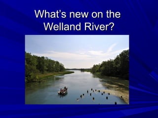
- 1. What’s new on theWhat’s new on the Welland River?Welland River?
- 5. Gauge station data used in 2010 studyGauge station data used in 2010 study
- 6. Gauge stations added since 2010 studyGauge stations added since 2010 study
- 7. Big Forks CreekBig Forks Creek This station was installed inThis station was installed in 2012 and records:2012 and records: Water LevelWater Level PrecipitationPrecipitation
- 8. E.C. Brown GaugeE.C. Brown Gauge This station became fully operationalThis station became fully operational in spring 2013 and records:in spring 2013 and records: Water LevelWater Level Water FlowWater Flow Water Flow DirectionWater Flow Direction PrecipitationPrecipitation
- 9. E.C. Brown GaugeE.C. Brown Gauge
- 10. E.C. Brown GaugeE.C. Brown Gauge
- 11. Ex. ‘Old Siphon’ Gauge – West SideEx. ‘Old Siphon’ Gauge – West Side This station was installed in 1986This station was installed in 1986 and records:and records: Water LevelWater Level
- 12. New ‘Old Siphon’ Gauge – East SideNew ‘Old Siphon’ Gauge – East Side This station was installed in October 2014This station was installed in October 2014 and records:and records: Water LevelWater Level
- 14. The data from these new stations will help us:The data from these new stations will help us: Improve NPCA flood forecasting and warning capabilities.Improve NPCA flood forecasting and warning capabilities. Better understand the impacts to flow on the river.Better understand the impacts to flow on the river. Improve the accuracy of any Welland River study, report, or model.Improve the accuracy of any Welland River study, report, or model.
- 15. Thanks for listening!Thanks for listening! Any questions?Any questions?