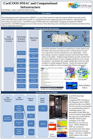
CariCOOS manages data from coastal observing assets and numerical models to support forecasting and understanding of coastal events. This includes data streams from buoys, mesonet weather stations, radar, and satellites. CariCOOS also runs atmospheric, ocean circulation, wave, and coastal inundation models on high performance computing facilities. The data undergo quality assurance processing before being made accessible through the CariCOOS web portal in standard formats and services to support stakeholders.
Using HEC-RAS to assess flash floods risk in arid regionsAhmed Saleh, Ph.D
Explain the utilization of HEC-RAS to two-dimensional simulation of flood wave propagation. also, show the application of ArcGis to draw flood risk maps.
At Esri UK Annual Conference 2014
The role of GIS in managing London’s Road Space
London is changing. The population is set to grow to 10 million by 2031 and the economy is recovering. London’s road space is central to enabling this growth. Alan will share with us how the team at TfL are implementing an enterprise-wide GIS as the foundation to support the planning and operational challenges associated with the variety and extent of construction and changes to the road space over the next 20 years. Alan’s challenge is how he can enable the transformation of London’s road space, whilst not impeding the movement of people and goods around the city so that London continues to be a great place to live, work, do business in.
Architecture of the regional satellite augmentation system for maritime appli...TELKOMNIKA JOURNAL
This paper describes architecture of regional satellite augmentation system (RSAS) in the function of the maritime space communications, navigation and surveillance (CNS) and global navigation satellite systems (GNSS) networks for enhanced safety and surveying of oceangoing ships, management and tracking of cargo, security of Mariners onboard commercial and passenger ships, yachts, sea platforms and other types of craft. The RSAS network are designed to improve vessel management and transport operation because of the enormous expansion of the world's merchant fleet. However, this network with a special ship tracking system can also improve the protection of merchant ships and their crews against piracy, violence, robbery and terrorist attacks. The international maritime organization (IMO) and shipping flag states have project for development of the international ship and port security (ISPS) and design to implement an approaching and port control system (APCS) by special code for all merchant vessels including determination, tracking and positioning of all ships movements in and out of the seaport area. The Maritime RSAS and CNS systems are integration components of the global satellite augmentation systems (GSAS) of two operational GNSS-1 military networks, such as the US global position system (GPS) and Russian global satellite navigation system (GLONASS). In this paper are also introduced the special effects of the ships RSAS networks and coastal movement guidance and control (CMGC) system for maritime application at sea and in seaports areas.
We are one of the leading manufacturer and exporter of high quality spare parts, automotive spare parts and industrial spare parts such as pistons, bushes, valves, piston rings, hydraulic pumps etc.
Presentation at 2014 Fall CCIF workshop focused on the evolution and value of information in the new energy economy as relates to electric industry business opportunities.
Предимствата на собствени платформи за онлайн магазиниStefan Chorbanov
Кой онлайн магазин е успешен и печеливш? Коя е най-голямата грешка при стартирането на онлайн магазин? Платформата или уеб агенцията -
кое е по-важно? Коя платформа за електронна търговия да избера?
STORMTOOLS* -Simplified Flood Inundation Maps for RI with Sea Level Rise (SLR)riseagrant
Malcolm L. Spaulding1
Chris Damon2
1Professor Emeritus, Ocean Engineering
2Environmental Data Center
University of RI
December 9, 2014
*http://www.beachsamp.org/research/stormtools/
Narragansett, RI
Hydrography is basically the science of surveying the physical features beneath water bodies like oceans, seas, lakes, and rivers. This is followed by measurement of other related factors to predict their change over a period of time while preventing disasters.
DSD-SEA 2023 Operational flood inundation forecasting in Australia - De Kleer...Deltares
Presentation by Simone De Kleermaeker (Deltares) at the Seminar Models and decision-making in the wake of climate uncertainties, during the Deltares Software Days South-East Asia 2023. Wednesday, 22 February 2023, Singapore.
L’Agence spatiale canadienne fournit de l’imagerie satellitaire aux différents ministères fédéraux depuis le lancement de RADARSAT-1 en 1995. Avec la venue de RADARSAT-2 en 2008, l’utilisation et des applications en Observation de la Terre ont fait un bond important au sein du Gouvernement du Canada. La raison de ce succès est liée principalement à l’accessibilité de la donnée. L’emphase sur les produits à valeur ajoutée est aussi un facteur important à considérer. Les prochaines générations de satellites telles que la Constellation RADARSAT seront une source accrue de données qui nécessitera une infrastructure géomatique importante afin de rendre disponible la donnée à un plus large public.
Reconnaissance for Hydrographic Survey ProjectNzar Braim
Reconnaissance for Hydrographic Survey Project
The system is able to withstand the harsh environment of the nearshore and acquire beach profile information across the surf zone. This paper describes the system and results of a comparison in Myrtle Beach, S.C., between surveys collected over a 3- day period by the personal watercraft system and by a similar system mounted aboard a traditional coastal survey vessel.
The bathymetric measurements for the personal watercraft-mounted echosounder surveying system display mean repetitive differences of 6 cm.
This workshop is an introductory course in Hydrographic surveying.
It is designed for surveyors, engineers, survey technicians, dredge operators, and hydrographers.
The course focuses on theoretical principles of hydrographic surveying, project description, operation, and map production.
9/8 THUR 10:45 | Statewide Regional Evacuation Study Program 3APA Florida
Jeffery Alexander
With an updated Evacuation Study for each of the 11 regions, Florida has one of the only statewide evacuation studies in the Nation. This session will educate participants on its fundamentals,
including HOW and WHY it was created and its implementation across a variety of planning disciplines. Explanations of the major components of the Evacuation Study, including its complex
evacuation transportation models, statewide coordination, behavioral surveys, and associated behavioral assumptions and advanced GIS modeling tools. Planners will gain a better understanding of the purpose, data and methodology of the Studies and how to implement its findings in their planning documents.
1. CariCOOS DMAC and Computational
Infrastructure
Description
Forecast & Numerical Model
Observing Assets & Data Streams
José Rodríguez , Jorge E. Capella and Adolfo Gonzalez
Caribbean Coastal Ocean Observing System, University of Puerto Rico at Mayagüez
Data Management and Communications (DMAC) is a set of rules required to make the regional-global ocean and coastal
observation data discoverable and accessible in a standard format thus supporting improved awareness, understanding and
forecasting of coastal events. CariCOOS as part of IOOS shares the responsibility complying with particular DMAC
requirements. CariCOOS manages two sets of data streams; from observing assets, including buoy & mesonet and derived from
forecast supporting numerical.
NASA ModisA
CHLA
CariCOOS Assets
ESA CHLA ESA Kd490
Observing
Assets
Processing
& Quality
Assurance
Data
Provider &
Archival
CariCOOS Web
Portal
U Maine/NDBC
GoMOOS Buoys (5)
EPSCoR-UVI
Buoy
CDIP, NDBC Rincon Wave Buoy
NDBC
Meteorological
PR Seismic Net. (2)
WeatherFlow
Meteorological
WeatherFlow (12)
NOAA,SIO,Rutgers
CODAR: Radar
Surface currents
NOAA
GlobeColour,-ESA
MODIS Sat
Ocean color
NASA Ocean
MODIS/VIIRS Sat
Ocean color
CariCOOS dual High
Performance
Computing (HPC) facilities at
Isla Magueyes and at UPRM
perform the bulk of our DMAC
activities and also accommodate
our computationally intensive
modeling program. The
atmospheric model WRF, the
ocean circulation model ROMS,
the ocean wave model SWAN,
ADCIRC-SWAN coastal
inundation, CoE CMS,
Bouss2D, etc. are all run in-
house. SWAN, ROMS and
WRF are executed in
operational mode while others
are used in process-oriented
fashion. The Navy’s AMSEAS
model output is also widely
utilized.
SWAN
Multigrid
Global AMSEAS
ROMS
CariCOOS maintains a network of coastal buoys, meteo stations and
HF Radar observing assets that provide a constant stream of wind,
wave and marine currents information to our stakeholders. These
data undergo a process of quality assurance and control before their
release to the public. Graphical representations are then created from
the various data streams to assess changing conditions in our coastal
environment. Our partners also supply satellite data which are made
available in suitable graphical formats. Finally the numerical data
are made available in various standard data formats and services.
Thredds server for publishing data files.
Data
Providers &
Products
High
Resolution
Regional
Model
Global
Model
(Input)
CariCOOS
Web Portal
San Juan:
Harbor and
Approaches
Southwest
PR
USVI:
Charlotte
Amalie
Multiple
SWAN
Domains
SWAN
ROMS
GFSWRF-NWS
NDFD
AMSEAS