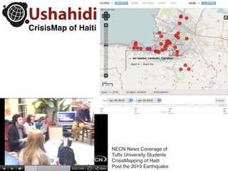
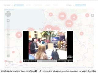
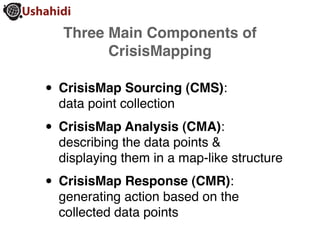
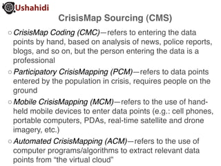
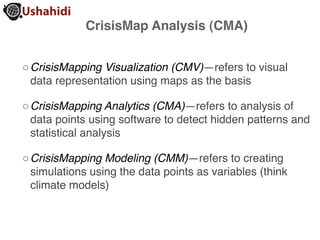
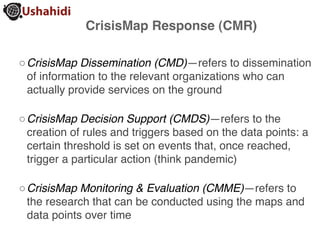
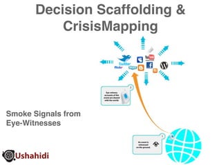
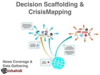
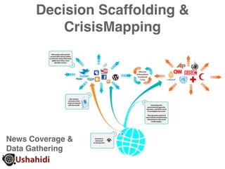
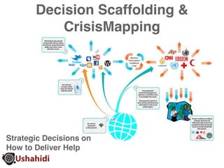
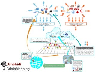
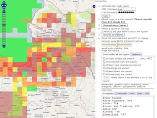
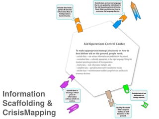
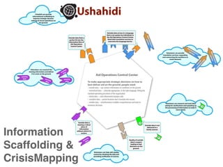
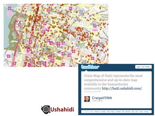
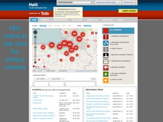
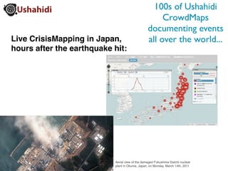
The document discusses crisis mapping, which involves collecting data from sources like social media and eyewitnesses during a crisis, analyzing and displaying the data on a map, and using the information to help direct emergency response efforts. It provides details on the different components of crisis mapping including data collection, analysis, and response, and how volunteers can help by providing translation, research, and quality control of the crowdsourced information. Crisis mapping tools like Ushahidi allow organizations to quickly set up systems to coordinate aid efforts during disasters using data from online reports.
Leveraging Social Media and SEO for Online Disaster Outreach: Lessons from SandyWilneida Negrón
Nearly one million people are affected by natural disasters each year. When thinking about response and recovery, social media has become the go-to tool for those affected by disasters. The goal of this toolkit is to help nonprofits and community groups harness the power of social media and search engine optimization (SEO) in emergency and disaster situations. It builds on the lessons learned from the tremendous effort of hundreds of community groups, government agencies, and ad hoc groups during and after Sandy and proposes best practices, new tips, and tools for cost-effective online disaster outreach.
The problem of matchmaking in electronic social networks is formulated as an optimization problem.
In particular, a function measuring the matching degree of fields of interest of a search profile with
those of an advertising profile is proposed.
Flexible Decision Support in Dynamic Interorganizational NetworksWolf Ketter
An effective Decision Support System (DSS) should help its users
improve decision-making in complex, information-rich, dynamic environments.
We present a feature gap analysis of current decision support
technologies, and we identify a set of DSS Desiderata, properties
that can contribute both effectiveness and flexibility to users in
such environments.
We show that there is a gap between the features
provided by current DSS technologies and the DSS Desiderata we
aim for. We present a design-science approach that
extends the boundaries of human decision-makers by creating a
new and innovative artifact called ``evaluator service networks''
at the confluence of people, organizations, and
technology.
Our artifact enables users to compose decision behaviors from
separate, configurable components, and allows dynamic construction
of analysis and modeling tools from small, single-purpose
evaluator services. The result is a network that can easily be
configured to test hypotheses and analyze the impact of various
choices for elements of decision processes.
We have implemented and tested this design in
an interactive version of the MinneTAC trading agent, an agent
designed for the Trading Agent Competition for Supply
Chain Management.
We present an example of an evaluator service network that
determines sales prices in a rich, dynamic trading environment.
Additionally we describe visual interface elements that allow users to see
and manipulate the configuration of the network, and to construct
economic dashboards that can display the current and historical
state of any node in the network.
32 Ways a Digital Marketing Consultant Can Help Grow Your BusinessBarry Feldman
How can a digital marketing consultant help your business? In this resource we'll count the ways. 24 additional marketing resources are bundled for free.
Open Humanitarian Initiative -- Google+ Hangout w/ Gisli OlafssonNetHopeOrg
NetHope and its partners are working on an ambitious 5 year initiative to revolutionize information sharing during times of crisis. During this G+ hangout we will introduce you to some of the key aspects of the Open Humanitarian Initiative and then open up for a dialog around this important issue.
OEM Presentation - IA and Emergency ResponseNoreen Whysel
An introduction to Information Architecture and Emergency Response technologies presented at the NYC Office of Emergency Management for the Women's History Month Breakfast. This presentation is a companion to my IA Summit presentation Information Architecture and Emergency Response, which goes into more detail on the kinds of technologies used in Emergency Response.
You need to know where your
vulnerabilities are before an
emergency strikes. A geographic
information system (GIS) gives you
tools to proactively identify risks
and take action. Powerful mapping
and analysis capabilities help you
plan ahead and be prepared.
Building IT Infrastructures to Interact with Big Data - Doug Roberts, Associ...IT Network marcus evans
Doug Roberts, a speaker at the marcus evans CIO Summit 2012, discusses how CIOs can handle and interact with big data sets.
Interview with: Doug Roberts, Associate Vice President for Digital Technologies and Chief Technology Officer, Adler Planetarium and Astronomy Museum
Global Pulse is an innovation initiative of the UN Secretary-General, harnessing today's new world of digital data and real-time analytics to gain a better understanding of changes in human well-being. Global Pulse hopes to contribute a future in which access to better information sooner makes it possible to keep international development on track, protect the world's most vulnerable populations, and strengthen resilience to global shocks.
Global Pulse functions as an innovation laboratory, bringing together expertise from UN agencies, governments, academia, and the private sector to research, develop, test and share tools and approaches for harnessing real-time data for more effective and efficient policy action.
Collaborative mapping is the crucial need in any rescue and relief operation. Our recent experience lead us to focus the research on the development of a unique platform [web and mobile] that allows different levels of geolocated information sharing, on a “user permissions” base [anonymus user, registered user level 1, ….]. Our approach is to use the solutions that are free and open [such as Google Maps, Google Earth, Google 3d, Ushahidi, OpenStreetMap, or Android apps for route tracking] and to develop a stable tool through the integration of diverse solutions ensuring a high level of sharing and collaboration among different players.
Web and mobile emergency networks to real-time information and geodata management.
Authors: DI LOLLI - LANFRANCO - LOMBARDO - RAPISARDI
VVF TAS Torino | Università di Torino | NatRisk | Open Resilience
5. Three Main Components of
CrisisMapping
• CrisisMap Sourcing (CMS):
data point collection
• CrisisMap Analysis (CMA):
describing the data points &
displaying them in a map-like structure
• CrisisMap Response (CMR):
generating action based on the
collected data points
6. CrisisMap Sourcing (CMS)
◦ CrisisMap Coding (CMC)—refers to entering the data
points by hand, based on analysis of news, police reports,
blogs, and so on, but the person entering the data is a
professional
◦ Participatory CrisisMapping (PCM)—refers to data points
entered by the population in crisis, requires people on the
ground
◦ Mobile CrisisMapping (MCM)—refers to the use of hand-
held mobile devices to enter data points (e.g.: cell phones,
portable computers, PDAs, real-time satellite and drone
imagery, etc.)
◦ Automated CrisisMapping (ACM)—refers to the use of
computer programs/algorithms to extract relevant data
points from “the virtual cloud”
7. CrisisMap Analysis (CMA)
◦ CrisisMapping Visualization (CMV)—refers to visual
data representation using maps as the basis
◦ CrisisMapping Analytics (CMA)—refers to analysis of
data points using software to detect hidden patterns and
statistical analysis
◦ CrisisMapping Modeling (CMM)—refers to creating
simulations using the data points as variables (think
climate models)
8. CrisisMap Response (CMR)
◦ CrisisMap Dissemination (CMD)—refers to dissemination
of information to the relevant organizations who can
actually provide services on the ground
◦ CrisisMap Decision Support (CMDS)—refers to the
creation of rules and triggers based on the data points: a
certain threshold is set on events that, once reached,
trigger a particular action (think pandemic)
◦ CrisisMap Monitoring & Evaluation (CMME)—refers to
the research that can be conducted using the maps and
data points over time
14. Information sources get
“quality” ranking based on
previous reliability. This is a
reputation-based system for
filtering data.
Information Filter—Quality Control for Data Information Filter—Quality Control for Data
Coming from the Blogosphere Coming from the Media & Reports
Volunteers all over the world can help with clarifying the
data, researching additional information, translation
services, entering data—spreading the workload among
willing and able individuals with ICT access.
A common geocoded database is constructed based
on ALL available data. Each data point can be tagged
based on its quality, urgency, and needed response.
A small set of “Control Room” individuals send out
requests for data clarification & translation services,
and tag the data. These volunteers have direct
Eye-witness connection to the rescue operations on the ground
accounts of the and to the social network of volunteers.
event are shared
with the world and
directly with aide
organizations &
volunteers.
People working on making
strategic decisions for
delivering aide to the local
population work with a
social network of volunteers
Rescue and Aid Operations on the Ground and standardized crisis
mapping database.
& CrisisMapping
15.
16. Outside data arrives in a language
that is not spoken by individuals in
dat service
Outside data finds a the Aid Operations Control Center.
a tr
perfect fit into the Need data translation services to
overcome the language barrier.
ans s
information flow of
2
lati
Aid Operations
Control Center.
on
1
Aid Operations Control Center
To make appropriate strategic decisions on how to
best deliver aid on the ground, people need:
3
Outside data is 4
Information missing a critical
piece of
information
without which it is
Outside data is not
delivered in a
timely manner.
useless.
Scaffolding & ing
iss a
m at
5
Quality of outside
d data is suspect
CrisisMapping leading to bad
decisions on the
ground.
17. Ushahidi can provide
informational scaffolding to
improve strategic decision
making of rescue operations on
the ground.
Outside data arrives in a language
that is not spoken by individuals in
dat service
Outside data finds a the Aid Operations Control Center.
a tr
perfect fit into the Need data translation services to
overcome the language barrier.
ans s
information flow of
2
lati
Aid Operations
Control Center.
on
da
1 ta
tr
ser ansla
vic tio
dat service
Volunteers can provide es n
translation services, expanding
a tr
and contracting the workforce as
ans s
needs demand.
lati
dat
s r
er ans
at
on
vi la
ce tio
n s
Volunteers can research the ng
ssi
missing information and deliver mi ata
it to crews on the ground. d
missing
Aid Operations Control Center
data miss missing
in
data g data To make appropriate strategic decisions on how to
best deliver aid on the ground, people need:
Volunteers can research and track data,
asking for clarifications and speeding up
the processing of information to make it
more timely.
3
Outside data is 4
missing a critical Outside data is not
piece of delivered in a
Information
information timely manner.
without which it is
useless.
5
ng
ssi
mi ata Quality of outside
Scaffolding &
d data is suspect
leading to bad
decisions on the
ground.
Volunteers can help with quality
CrisisMapping
control by checking the data and
providing verification of sources.
20. 100s of Ushahidi
CrowdMaps
documenting events
Live CrisisMapping in Japan, all over the world...
hours after the earthquake hit:
Aerial view of the damaged Fukushima Daiichi nuclear
plant in Okuma, Japan, on Monday, March 14th, 2011
21. How Easy Is It?
• Ushahidi runs its own servers — no need to
setup complicated software system on your
own server (at least for simple projects).
• Ushahidi has comprehensive documentation
and technical support — it’s possible to setup
a CrowdMap in one afternoon!
Ushahidi.com
• Anyone can do it! wiki.Ushahidi.com
If you know what you want to
accomplish and have clear goals for
your CrowdMap, Ushahidi makes it
very easy to set up and go.
LinkedIn.com/groups/Crowdmappers-4215298
22. CostOfChicken.com is a CrowdMap setup by
San Francisco high school students. It tracks the
“true costs of food” around the world.