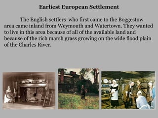
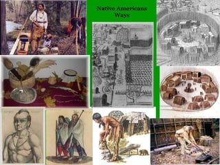
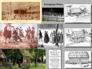
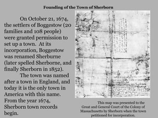
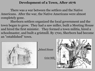
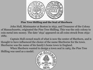
17th Century History of
Sherborn
Native Americans and Early
European Settlement
Table of Contents
Native Americans
Earliest European Settlement
Incorporation 1674
King Philip’s War 1675-77
Early Maps
Building a Town
Size in Area
Sherborn was once part of an area called Boggestow, which included a
huge area of land from the Charles River north almost to the current town of
Sudbury, west almost to Mendon, and east into present-day Natick.
In 1674, Sherborn comprised roughly six square miles. This
was an area about 5,000 acres larger than the town’s current size. Today
Sherborn is 11,000 acres.
Location
The current borders of Sherborn are about 18 miles south east of Boston.

Sewell Brook

Forest

Farm Pond
Map Showing Outlines of Boggestow
The area known as Boggestow was west of the Charles River, east to Natick, north to
Sudbury, and west to Mendon. In the southeastern part of this huge area, the town of
Sherborn was created in 1674.
Boggestow
Sherborn
Native Americans in the BoggestowArea
For thousands of years before the Europeans came to
Boggestow, Native Americans lived here. A few artifacts, like
the tomahawk shown below, have been plowed up or dug up
near Rocky Narrows and Farm Pond.
Native Americans in the BoggestowArea
What tribe lived here? The Nipmuc tribe was a farming,
hunting, fishing, and gathering tribe, who were less warlike
than some of their neighbors. Their area included Sherborn and
the lands to the west as far as Mt. Wachusett.

Sherborn
Native Americans in the Boggestow Area
Both the Nipmuc and Massachusett tribes lived in Boggestow.
Sherborn
Native Americans in the Boggestow Area
In the 1600s, the sachem (or leader) of the Nipmucs was a squaw or
woman, who lived near Wachusett Mountain. After her death in 1647, the people
couldn’t agree on a new leader, and so they split up into as many as five groups, each
with a different sachem. One of these groups settled in the southwest part of
Sherborn, near Nason Hill Road. There they built their "stannocks" or wigwams.
That part of Sherborn used to be called “Stannox” in earlier times.
Earliest European Settlement
The English settlers who first came to the Boggestow
area came inland from Weymouth and Watertown. They wanted
to live in this area because of all of the available land and
because of the rich marsh grass growing on the wide flood plain
of the Charles River.
Native Americans
Ways
European Ways
Earliest European Settlement in the Boggestow Area
Thomas Holbrook and Nicholas Wood settled in Boggestow in 1652. The
Wood-Holbrook land was about 600 acres of woods and open fields near the
Sewell Brook and the Charles River.
Other settlers soon followed. The Boggestow grants carved up a huge
area of land. Each grant was supposed to include open land, water and woods.
Plenty of land was also left open for later settlers who might be accepted into the
community.
Early Settlers Were Citizens of Medfield
Since there was no town of Sherborn yet, these earliest settlers were
actually citizens of Medfield, a established town across the Charles River. For
the next 25 years, the settlers of Boggestow were actually citizens of Medfield.
All Boggestow’s records were kept in Medfied, including records of births,
deaths, burials, and church services.
Before a bridge was built, crossing the river was a hardship, and the
women and children often had to miss church and stay home. One of the early
physicians, Dr. Fairbanks, actually drowned in the Charles River while making
a house call.

Death Bridge over the Charles River between Sherborn and Medfield, near where settlers
first set foot in Sherborn. First bridge built 1656 – 1672.
Founding of the Town of Sherborn

On October 21, 1674,
the settlers of Boggestow (20
families and 108 people)
were granted permission to
set up a town. At its
incorporation, Boggestow
was renamed Sherburne
(later spelled Sherborne, and
finally Sherborn in 1852).
The town was named
after a town in England, and
today it is the only town in
America with this name.
From the year 1674,
Sherborn town records
begin.

This map was presented to the
Great and General Court of the Colony of
Massachusetts by Sherborn when the town
petitioned for incorporation.
Development of a Town, After 1676
There was a war between the settlers and the Native
Americans. After the war, the Native Americans were almost
completely gone.
Sherborn settlers organized the local government and the
town began to grow. They had a saw miller, built a Meeting House
and hired the first minister. They formed a town militia, hired a
schoolmaster, and built a gristmill. By 1700, Sherborn had become
an "established" town.

School House
Grist Mill
Development of a Town, After 1676

A common house style of the 17th century was the saltbox, which
had a shorter roof in front and a longer roof in back. Boxes that
held salt had similar shapes, hence the name “saltbox.”
Development of a Town, After 1676

Another saltbox-style house built before 1700 in Sherborn is the
Bull-Phipps House, which is located at 70 Washington Street. It still stands
there today.
Pine Tree Shilling and the Seal of Sherborn

John Hull, Mintmaster at Boston in 1652, and Treasurer of the Colony
of Massachusetts, originated the Pine Tree Shilling. This was the only colony to
coin metal into money. The date '1652' appeared on all coins struck from 16521682.
Captain Hull owned much of what is now the center of Sherborn, and is
thought to have influenced the choice of the name Sherborne for the town.
Sherburne was the name of his family's home town in England.
When Sherborn wanted to design a town seal in 1965, the Pine Tree
Shilling was used as a model.

17th century sherborn revised

  • 1.
    17th Century Historyof Sherborn Native Americans and Early European Settlement
  • 2.
    Table of Contents NativeAmericans Earliest European Settlement Incorporation 1674 King Philip’s War 1675-77 Early Maps Building a Town
  • 3.
    Size in Area Sherbornwas once part of an area called Boggestow, which included a huge area of land from the Charles River north almost to the current town of Sudbury, west almost to Mendon, and east into present-day Natick. In 1674, Sherborn comprised roughly six square miles. This was an area about 5,000 acres larger than the town’s current size. Today Sherborn is 11,000 acres. Location The current borders of Sherborn are about 18 miles south east of Boston. Sewell Brook Forest Farm Pond
  • 4.
    Map Showing Outlinesof Boggestow The area known as Boggestow was west of the Charles River, east to Natick, north to Sudbury, and west to Mendon. In the southeastern part of this huge area, the town of Sherborn was created in 1674. Boggestow Sherborn
  • 5.
    Native Americans inthe BoggestowArea For thousands of years before the Europeans came to Boggestow, Native Americans lived here. A few artifacts, like the tomahawk shown below, have been plowed up or dug up near Rocky Narrows and Farm Pond.
  • 6.
    Native Americans inthe BoggestowArea What tribe lived here? The Nipmuc tribe was a farming, hunting, fishing, and gathering tribe, who were less warlike than some of their neighbors. Their area included Sherborn and the lands to the west as far as Mt. Wachusett. Sherborn
  • 7.
    Native Americans inthe Boggestow Area Both the Nipmuc and Massachusett tribes lived in Boggestow. Sherborn
  • 8.
    Native Americans inthe Boggestow Area In the 1600s, the sachem (or leader) of the Nipmucs was a squaw or woman, who lived near Wachusett Mountain. After her death in 1647, the people couldn’t agree on a new leader, and so they split up into as many as five groups, each with a different sachem. One of these groups settled in the southwest part of Sherborn, near Nason Hill Road. There they built their "stannocks" or wigwams. That part of Sherborn used to be called “Stannox” in earlier times.
  • 9.
    Earliest European Settlement TheEnglish settlers who first came to the Boggestow area came inland from Weymouth and Watertown. They wanted to live in this area because of all of the available land and because of the rich marsh grass growing on the wide flood plain of the Charles River.
  • 10.
  • 11.
  • 12.
    Earliest European Settlementin the Boggestow Area Thomas Holbrook and Nicholas Wood settled in Boggestow in 1652. The Wood-Holbrook land was about 600 acres of woods and open fields near the Sewell Brook and the Charles River. Other settlers soon followed. The Boggestow grants carved up a huge area of land. Each grant was supposed to include open land, water and woods. Plenty of land was also left open for later settlers who might be accepted into the community.
  • 13.
    Early Settlers WereCitizens of Medfield Since there was no town of Sherborn yet, these earliest settlers were actually citizens of Medfield, a established town across the Charles River. For the next 25 years, the settlers of Boggestow were actually citizens of Medfield. All Boggestow’s records were kept in Medfied, including records of births, deaths, burials, and church services. Before a bridge was built, crossing the river was a hardship, and the women and children often had to miss church and stay home. One of the early physicians, Dr. Fairbanks, actually drowned in the Charles River while making a house call. Death Bridge over the Charles River between Sherborn and Medfield, near where settlers first set foot in Sherborn. First bridge built 1656 – 1672.
  • 14.
    Founding of theTown of Sherborn On October 21, 1674, the settlers of Boggestow (20 families and 108 people) were granted permission to set up a town. At its incorporation, Boggestow was renamed Sherburne (later spelled Sherborne, and finally Sherborn in 1852). The town was named after a town in England, and today it is the only town in America with this name. From the year 1674, Sherborn town records begin. This map was presented to the Great and General Court of the Colony of Massachusetts by Sherborn when the town petitioned for incorporation.
  • 15.
    Development of aTown, After 1676 There was a war between the settlers and the Native Americans. After the war, the Native Americans were almost completely gone. Sherborn settlers organized the local government and the town began to grow. They had a saw miller, built a Meeting House and hired the first minister. They formed a town militia, hired a schoolmaster, and built a gristmill. By 1700, Sherborn had become an "established" town. School House Grist Mill
  • 16.
    Development of aTown, After 1676 A common house style of the 17th century was the saltbox, which had a shorter roof in front and a longer roof in back. Boxes that held salt had similar shapes, hence the name “saltbox.”
  • 17.
    Development of aTown, After 1676 Another saltbox-style house built before 1700 in Sherborn is the Bull-Phipps House, which is located at 70 Washington Street. It still stands there today.
  • 18.
    Pine Tree Shillingand the Seal of Sherborn John Hull, Mintmaster at Boston in 1652, and Treasurer of the Colony of Massachusetts, originated the Pine Tree Shilling. This was the only colony to coin metal into money. The date '1652' appeared on all coins struck from 16521682. Captain Hull owned much of what is now the center of Sherborn, and is thought to have influenced the choice of the name Sherborne for the town. Sherburne was the name of his family's home town in England. When Sherborn wanted to design a town seal in 1965, the Pine Tree Shilling was used as a model.