1. 1
APPLYING THE ISO 31000 RISK ASSESSMENT FRAMEWORK
TO COASTAL ZONE MANAGEMENT
V Rollason1
, G Fisk2
, P Haines1
1
BMT WBM Newcastle, NSW
2
BMT WBM Brisbane, QLD.
Abstract
The NSW Government’s Sea Level Rise Policy Statement, Coastal Planning Guideline:
Adapting to Sea Level Rise and Draft Guidelines for Preparing Coastal Zone
Management Plans have endorsed the use of a ‘risk assessment approach’ to coastal
zone management. The risk assessment framework is used extensively in industry and
government as it provides a process for determining sensible management outcomes
even when there is considerable uncertainty or lack of data. Thus, the approach is ideal
for managing the issues surrounding climate change adaptation and coastal hazards.
This paper outlines a methodology for applying the Australian Standard for Risk
Management (AS/NZS ISO 31000:2009) to coastal zone management as prescribed
within the various NSW Government guidelines. Steps within the risk management
framework, such as ‘identifying the risks’, ‘analysing risk likelihood and consequence’,
‘prioritising the risks’, and ‘risk treatment’, can be applied to various phases of the
coastal zone management process. Coastal hazards may be defined in terms of a
‘likelihood’ of hazard extent. At the management phase the extent and type of coastline
development, recreational demand, ecological and other coastal values can be used to
determine the ‘consequences’ of coastal hazards. Combining likelihood and
consequence to define an overall level of risk provides the foundation for prioritising
management efforts and resources towards the highest priority coastal risks.
There remains considerable uncertainty with respect to climate change, particularly
surrounding the timeframe, extent and types of impacts that may occur. The risk
assessment framework can help to accommodate uncertainty, as outcomes may be
assessed and compared even when there is little available data. Given the uncertainty
in timeframes for climate change impacts, our methodology advocates developing
management responses that are trigger-based, rather than time-based. Using the
adaptation tool developed by Fisk and Kay (2010), this paper explores the application
of risk-based coastal zone planning using examples from NSW.
Background
Uncertainties associated with future climate change presents huge challenges to local
government and the general public. Decisions made today are likely to have
ramifications well into the future (depending on the type of infrastructure or
development and its design life), so consideration of extended timeframes is essential,
even though climate-related risks may not manifest as impacts for several decades.
Irrespective of climate change, coastal hazards have always presented a challenge to
planners and managers. There is generally limited data on coastal processes (e.g.
historical shoreline change, wave climate, water levels, etc.) and there are many
different ways to assess the extent of hazards, which add to the uncertainty in
estimating coastal hazards.
2. 2
The risk assessment framework is a robust methodology for dealing with outcomes that
are uncertain, limited data to assess outcomes, or for impacts with uncertain
timeframes. The use of a risk-based approach to manage coastal hazards accords with
current international best practice for natural resource management. This was
recognised by the endorsement of the risk approach by the NSW Government in recent
guideline documents, particularly the Draft Guidelines for preparing Coastal Zone
Management Plans (the CZMP Guidelines) released in August 2010.
The CZMP Guidelines supersede the former Coastline Management Manual (NSW
Government, 1990) and Estuary Management Manual (NSW Government, 1992) and
recent Coastal Risk Management Guide: Incorporating sea level rise benchmarks in
coastal risk assessments (2010). The key change within the CZMP Guidelines is that
the adoption of ‘an adaptive risk-based management approach’ is prescribed as a
principle for coastal management. Councils and the NSW Government are said to have
acted in ‘good faith’ where coastal zone management plans have been prepared
substantially in accordance with such coastal management principles.
The risk approach guides coastal planners (e.g. councils) to consider, analyse and
prepare for impacts that may be greater than expected, or manifest earlier than
expected. This includes setting trigger levels to implement strategies, developing short
and long term contingencies, and using a suite of strategies that either reduce the
likelihood and / or the consequence from coastal risks.
This paper demonstrates a methodology for applying the AS/NZS ISO 31000:2009
Risk Management Principles and Guidelines to coastal zone management. The various
aspects of a standard risk management process and their application to the
development of a coastal zone management plan are given below.
The Risk Assessment Process
Risk is defined as the ‘effect of uncertainty on objectives’ (AS/NZS ISO 31000:2009).
The objectives can be financial, health and safety, environmental and so on. The risk
management process involves the following steps, as given in ISO 31000:2009:
setting objectives and establishing the context of the risk assessment;
identifying the risks;
analysing the risks to determine the level of risk, which is defined as the
combination of the consequences and likelihood of the risk;
evaluating the risk, to decide if a risk is acceptable, tolerable or intolerable /
unacceptable;
treating the risks, focusing on those risks which are intolerable; and
monitoring and review, to continuously refine and improve the assessment and risk
treatments.
Each of these steps can be easily adapted to the coastal zone management process.
The steps involved in a risk assessment (adapted from the Australian Standard for Risk
Management ISO 31000:2009) and their relationship to the coastal zone management
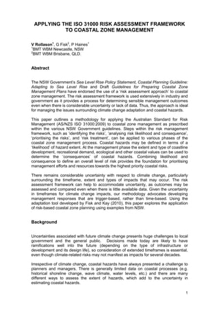
process are presented in Figure 1, with discussion herein.
3. 3
Figure 1 ISO 31000:2009 Risk Assessment Framework Adapted to Coastal
Management
Risk Assessment
Risk Identification
What are the built, natural and
community assets at risk from
various coastal hazards? (e.g. beach
erosion, long term recession, coastal
inundation etc)
Establishing the context
What are our objectives for Coastal
Zone Management?
What are our Performance
Indicators?
Risk Analysis
What are the likelihood and the
consequence associated with each
coastal risk?
What is the overall level of risk (high,
medium, low)?
Risk Evaluation
What is a tolerable level of risk?
Are there controls / mitigating actions
already in place?
Risk Treatment Options
What measures can be used to
reduce the risk to a tolerable level?
What are the costs and benefits of
the measures?
At what trigger level do we
implement the measures (giving
sufficient time for implementation)?
Implement Management
Strategies
MonitoringandReview
ArePerformanceIndicatorsbeingmet?Hasthelevelofriskchangedovertime?
CommunicationandConsultation
StakeholderandCommunityLiaison
4. 4
Establishing the Context and Setting Objectives
The Coastal Protection Act 1979, the CZMP Guidelines and other associated guideline
documents set the context for coastal management, including intended outcomes for
coastal zone management plans.
The draft CZMP Guidelines state that coastal zone management plans shall focus
upon minimising the risks from coastal hazards to public and private assets. This is in
recognition of the fact that coastal hazards are not explicitly managed through any
other statutory process. For example, issues associated with recreational amenity and
access shall only be assessed in terms of the impact upon or impact from coastal
hazards. This is because recreational amenity and access, while important, are already
managed through other council and state agency operational or statutory plans.
Minimising the risks arising from natural coastal processes is therefore the key aspect
of the context and objective of the risk assessment and subsequent coastal
management actions.
The objectives for coastal zone management can also be drawn from the NSW Coastal
Policy 1997, in particular, the aim of Ecologically Sustainable Development and
accommodating natural coastal processes in the coastal zone. The objectives for
coastal zone management shall then be tailored to the specific local conditions, in
consultation with council, stakeholders and community. Performance indicators that
can be used to measure the consistency with or achievement of objectives should also
be determined at this stage.
Establishing the context of the risk assessment involves describing the location and
extent of the study area and the coastal processes operating in this area that may
generate risks. The CZMP Guidelines separate the coastline into its broad
geomorphologic sub-groups, being either sandy beach systems, bluffs and cliffs
comprising rock and other consolidated material, or the entrance area of
estuaries/watercourses at the coast. It is important to set the context for which (part or
all) of the geomorphologic sub-groups the risk assessment and coastal management
plan shall address. The description of study location, scope of the study and coastal
processes accords with the coastal processes and hazards definition phase of the
traditional coastal planning process.
The risk assessment aims to explore (1) the potential impact (i.e. damage) on (2) a
particular value (e.g. house) from (3) a threatening process (e.g. waves, sea level rise).
Thus, as part of establishing the context, the economic, social and environmental
values of the land where the plan applies should also be described.
Defining risk criteria is another key aspect of establishing the context for the risk
assessment. This includes preparing likelihood and consequence scales and their
combination into a risk matrix to determine the level of risk. Another important aspect of
risk criteria is defining the level at which risk is deemed acceptable, tolerable and
intolerable, with intolerable risks requiring treatment as a priority. Guidance as to the
acceptability of risks is provided within the draft CZMP Guidelines. The level of risk that
is deemed acceptable, tolerable and intolerable should be modified for local conditions
in consultation with council and other stakeholders.
5. 5
Identify the Risks
Once the context for the risk assessment and objectives for coastal management are
set, identification of risk becomes more straightforward. Given that the key aim of
coastal management shall be to minimise impacts that arise from coastal processes,
these coastal processes are the principal source of risk. Coastal hazards derived from
coastal processes are well defined in NSW, and are described in the former Coastline
Management Manual (CMM, NSW Government 1990) and the more recent CZMP
Guidelines.
Eight coastal hazards were defined in the CMM (1990). In the CZMP Guidelines, the
list of hazards remains essentially the same, with focus on the hazards of:
beach erosion,
shoreline recession (including due to sea level rise),
coastal (oceanic) inundation,
coastal entrance or watercourse instability and
coastal cliff or slope instability.
Where significant site specific issues exist, sand drift may also be assessed.
Analyse the Risks
The analysis of risks involves considering the likelihood and consequence of the
identified risks, to determine the overall level of risk (extreme, high, medium, low). Any
risk assessment to manage coastal hazards will be incomplete without describing the
likelihood as well as the consequence of coastal hazards. The likelihood is both
spatially and temporally dependent. For example, likelihood increases with distance
towards the shoreline and with time (assuming increasing sea levels in the future). The
consequence of the risks will largely relate to the extent of existing or potential future
development and the values attributed to land within the coastal zone (e.g. aesthetic,
recreational, ecological, etc.).
The risk assessment process inherently requires that uncertainty is transparently
described, but also, provides for a scale of likelihood or consequence to be ascribed to
what may possibly occur. That is, as part of the risk assessment, hazard impact greater
than expected may be described, but also qualified by the likelihood of such an impact
occurring.
Likelihood
There are inherent uncertainties in climate change science and also in the assumptions
used to assess coastal processes and hazards. Setting hazard lines without describing
their likelihood is of little value when describing the uncertainty associated with
estimating the hazard extent or climate change.
Hazard definition can only be a best estimate, because it is based upon limited beach
change data, variable and limited climate data, assumptions used in model packages
and other limitations in assessment methodology. Climate change adds additional
uncertainty to the assessment of risk from coastal processes, such as described by
Cowell et al. (2006):
6. 6
“uncertainty about climate change itself; uncertainty about its effect on sea levels
and wave climates; and process uncertainty in modelling beach responses on
timescales relevant to climate change (decades or longer)”.
Without being transparent about the assumptions used in models and assessment of
coastal hazards, a ‘false sense of confidence’ has been ascribed to the hazard
assessment (Cowell et al., 2006), as has occurred in NSW in the past.
Ascribing likelihood to the hazard estimates provides transparency regarding the
uncertainties, limitations and assumptions used to assess hazards. In addition,
ascribing likelihood to coastal hazards can educate coastal planners and the wider
community that hazard lines are estimates only and not precise predictions of future
shoreline response.
Indeed, a series of hazard lines providing more than one probability or likelihood could
be defined, and provides better guidance for coastal managers regarding the
imminence of coastal risk for which planning is required. For example at Coffs Harbour,
three hazard ‘likelihoods’ were determined, being ‘almost certain’, ‘unlikely’ and ‘rare’,
as given in Figure 2. The terminology is consistent with guidance given in the
Companion to the Australian Standard (Standards Australia, 2004), and these terms as
defined for the Coffs Harbour example are given in Table 1.
Table 2 provides the inputs to definition of these hazard likelihood zones for the beach
erosion and recession hazards over the immediate, 2050 and 2100 timeframe at Coffs
Harbour.
The ‘unlikely’ zone incorporates conservative estimates of coastal hazard impact. The
‘rare’ zone provides for hazard impacts greater than predicted, such as due to extreme
climate conditions or climate change aspects that may theoretically occur but for which
there is no recorded data. The ‘rare’ hazard zone conveys to coastal planners and the
wider community the potential (and the likelihood of that potential, i.e. rare) of hazard
impacts greater than predicted, enabling more advanced planning options. The ‘rare’
hazard may be regarded in a similar fashion to the Probable Maximum Flood (PMF)
zone used in floodplain management.
The ‘almost certain’ line defines an area under imminent threat. For future hazards at
2050 and 2100, the ‘almost certain’ line can be a representation of the risk from coastal
processes without the inclusion of sea level rise, such as adopted at Coffs Harbour,
reflecting the uncertainty associated with sea level rise projections. This is consistent
with recent NSW government guidelines regarding the setting of hazard zones with and
without sea level rise, and conveys to the community and planners the coastal area
that will almost certainly experience impact.
Methods for assessing hazards will continue to improve. Indeed, as modelling
techniques and approaches improve into the future, it is anticipated that mathematical
probabilities may be ascribed to hazard extents. However, at the present time the risk
assessment process requires transparency about the data and methods used to
identify risks, to ensure planners and managers are informed to make appropriate
decisions, and this can be done through a qualitative approach.
7. 7
Table 1 Risk Likelihood / Probability, Coffs Harbour
Probability
Almost Certain
There is a high possibility the event will occur as there is a
history of periodic occurrence
Likely
It is likely the event will occur as there is a history of casual
occurrence
Possible There is an approximate 50/50 chance that the event will occur
Unlikely
There is a low possibility that the event will occur, however,
there is a history of infrequent and isolated occurrence
Rare
It is highly unlikely that the event will occur, except in extreme
circumstances, which have not been recorded historically.
Table 2 Beach Erosion and Shoreline Recession Hazard Probability Zones,
Coffs Harbour
Probability Immediate 2050 2100
Almost Certain
‘average’ beach
erosion
1
Immediate ‘average’ beach
erosion
+ Harbour Impact
Immediate ‘average’ beach
erosion
+ Harbour Impact
Likely NM
2
NM NM
Possible NM NM NM
Unlikely
‘maximum’ beach
erosion at any
position along the
beach
1
Immediate ‘maximum’ beach
erosion
+ Harbour Impact
+ 0.4 m SLR
Immediate ‘maximum’ beach
erosion
+ Harbour Impact
+ 0.9 m SLR
Rare
‘extreme’ beach
erosion
3
Worst Case of either:
Immediate ‘maximum’ beach
erosion + Harbour Impacts +
0.7 m SLR
OR
Immediate ‘extreme’ beach
erosion + Harbour Impacts +
0.4 m SLR
OR
Immediate ‘maximum’ beach
erosion + Harbour Impacts +
0.4 m SLR + more easterly
wave climate
Worst Case of either:
Immediate ‘maximum’ beach
erosion + Harbour Impacts +
1.4 m SLR
OR
Immediate ‘extreme’ beach
erosion + Harbour Impacts +
0.9 m SLR
OR
Immediate ‘maximum’ beach
erosion + Harbour Impacts +
0.9 m SLR + more easterly
wave climate
1
Measured over the past 3 - 5 decades
2
NM = Not Mapped
3
Assumed to be ‘maximum’ erosion plus difference between ‘maximum’ and ‘average’ beach
erosion
8. 8
Consequence
The consequence of coastal risks such as erosion on the built, social and natural
environment depends largely on the values of the land affected by the coastal risk. This
includes the type of development and assets and their value to the community, for
example, public assets such as surf clubs or stormwater infrastructure, the beach
amenity for community or private residences. As stated by the NSW Government in
various guidelines (DECCW, 2010; DP 2010), public expenditure will be prioritised
towards public infrastructure and public safety before private property. This can be
conveyed through the consequence scale used to assess the level of risk. An example
consequence scale based upon land use and community assets is given in Table 3.
Once the consequence scale is set, investigation of land values described by GIS
spatial data and community input can be used to accurately map and differentiate
areas of different consequence in the coastal zone. Land use data can provide the
starting point for consequence mapping. This can then be augmented with vegetation
mapping and other records to map areas of high conservation value, and with
community consultation to specify areas of high recreational / social value. GIS
mapping can also delineate the consequence of erosion to beach areas that are limited
by back beach development, or to significant ecology that is not protected within
national parks or limited in geographic extent.
An example consequence map from Coffs Harbour is shown in Figure 3, with the
consequence of erosion of critical infrastructure such as major arterial roads, airport or
railway land considered catastrophic while erosion of open space may have relatively
minor consequence.
Table 3 Risk Consequence Scale
Consequence
Community Assets Infrastructure &
Services
Land Use
Catastrophic
Long term loss of community assets
and infrastructure. Irreversible loss of
private property
Regional Infrastructure (e.g. Pacific
Highway, Airport, Railway, Harbour,
Hospitals, STPs), major regional
economic industries
Major
Major asset damage, severe impact on
community services and assets. Long
term loss of private property.
Private property (residential)
High value public assets (e.g. beach
amenity where migration not possible
due to backing development, schools,
churches, heritage sites, etc)
Moderate
Considerable impact upon access to
services, infrastructure (roads,
hospitals, airports, STP, schools,
beach access). Major long term
impact upon private property.
Commercial business land, intensive /
productive agriculture lands
Minor
Minor short term impacts (mainly
reversible) on community services.
Minor long-term impacts to private
property.
Rural land (low productivity)
High value vegetation outside of
National Parks and State Forest, with
limited geographic extent (e.g.
SEPP14, SEPP26, EECs)
Insignificant
Little to no impact on communities and
their access to services.
Minor impact to private property.
National Park, State Forest, low value
open space / public land
9. 9
Level of Risk: Likelihood X Consequence
As given in ISO 31000:2009, the level of risk is expressed in terms of the product of
consequence and likelihood. A risk matrix should be defined to describe the
combination of likelihood and consequence to give a level of risk, for example,
extreme, high, medium and low, as used in the example from Coffs Harbour, Table 4.
Where likelihood and consequence are mapped, a risk map describing the level of risk
to areas in the coastal zone can be developed, such as for Coffs Harbour in Figure 4.
In this example, the mapping enables identification of the level of risk to critical built
assets from erosion and recession by 2100. The mapping can also highlight the level of
risk from erosion and recession on community assets such as beach amenity on highly
developed beachfronts, or level of risk of coastal erosion to significant ecology outside
of protected parks and forest.
Table 4 Example Risk Matrix defining Level of Risk from Likelihood x
Consequence
CONSEQUENCE
Insignificant
1
Minor
2
Moderate
3
Major
4
Catastrophic
5
Almost
Certain
5
low medium high extreme extreme
Likely
4 low medium high extreme extreme
Possible
3 low medium high high extreme
Unlikely
2 low medium medium high extreme
Rare
1 low low medium medium high
LIKELIHOOD
13. 13
Evaluate the Risks
Risk evaluation, as defined in ISO 31000: 2009 involves comparing the results of the
risk analysis with risk criteria, to determine whether the level of risk is acceptable,
tolerable or intolerable, with intolerable risks requiring treatment as a priority. Given
finite resources, it will not be possible to treat every risk, and indeed, there is a point
where the cost of implementing a treatment far outweighs the benefit (or risk reduction)
gained.
Prior to investigating new management measures, the existing controls or measures in
place that may reduce the level of risk are evaluated. The combination of likelihood and
consequence in the previous step presents the ‘unmitigated’ risk, and there may
already be controls in place to manage such risks. For example, while the ‘unmitigated’
risk of coastal inundation may be high, when existing floodplain development controls
are applied, the risk level may be lowered to tolerable.
Once existing management measures have been included in the assessment, the risk
evaluation process identifies the priority risks requiring treatment. Management effort
shall be aimed towards the higher levels of risk (e.g. extreme and high) that would be
deemed intolerable. The monitoring and review process enables tracking of all risks, to
ensure they remain within an acceptable range.
Treating the Risks: Preparing Coastal Management Actions
The process of developing management options as part of coastal zone management
plans aims to avoid, reduce or eliminate intolerable risks. Management options can be
designed to reduce the likelihood of the risks (e.g. planning setbacks to reduce the
likelihood of shoreline recession impacts) or the consequence of the risk (e.g.
emergency management to reduce the consequence of shoreline recession) or both.
Further cost benefit analysis is then used to determine which of the risk treatments will
provide the greatest benefit (relative to cost) in treating the highest priority risks. These
would be selected for implementation within a coastal zone management plan.
The traditional coastal management options of ‘retreat’, ‘protect’ or ‘accommodate’
remain largely valid. However, there has (and will continue to be) innovation in what
such options involve, and where and when they are implemented.
Unlike flooding or coastal inundation risks which may occur at any time, recession and
erosion tends to occur over years with preceding events giving warning of the imminent
threat. Such time warnings can be used to advantage in developing and implementing
management options, particularly where the action may be costly or difficult for
community to accept or implement.
Fisk and Kay (2010) provide a method for setting triggers along a time continuum for
climate change adaptation actions. The method was developed as part of the climate
change adaptation planning process, in recognition that at some point in the future,
difficult decisions with more significant tradeoffs will need to be made. Fisk and Kay
(2010) identify the need to examine three stages for each identified risk as part of the
risk assessment process, being:
the current condition of the parameter being examined;
the undesirable end state or result that needs to be avoided; and
identification of one or more trigger points along a time continuum that are flags to
managers where more aggressive or decisive actions must be implemented in
order to avoid the undesirable end state.
14. 14
The trigger points are set to flag the ‘level of acceptable change’ before management
action (e.g. protect, accommodate or retreat) must be implemented. The trigger setting
method is demonstrated in Figure 5.
This trigger-setting tool is readily applicable to coastal hazards impacts where the
undesirable impact can be defined, but the exact timing of such an impact is less well
known. When devising coastal management options that are more costly and / or have
greater trade-offs, this tool can be used to determine trigger points for implementing
such options. A triggered approach avoids actions being implemented until it becomes
necessary, with time in the interim to both improve data regarding the impact and
funding resources. It also recognises that some hazard or climate change impacts may
not eventuate. If this is the case, then the community has not been unnecessarily
burdened by having to adopt costly management responses.
Figure 5 The Time Continuum Model of Fisk and Kay (2010)
15. 15
The timing of erosion and recession impacts can also be used to advantage by
planners in generating funds to implement more costly actions that have high
community benefit. Acquisition theoretically provides a ‘win-win’ scenario in which
landholders are adequately compensated for at-risk coastal land and the community
regains public reserves to ensure continuation of the beach amenity. In practice,
acquisition has been difficult to implement. Unlike flood-prone land, coastal land is
typically the most expensive real estate in Australia, and in most cases, councils and
state government haven’t the funds to acquire such properties.
One model for the acquisition of land by Council that can be investigated for its
financial viability is as follows. Given the timeframes for most private property at risk
from recession is greater than 20-30 years, councils may be able to buy the property
under typical mortgage-type loan arrangements (underwritten by Government, financial
institution or other investment mechanism), then rent back the property at market rates,
providing a mechanism for council to meet loan repayments. At such time in the future
when the recession impact manifests, the rental property can be demolished and
returned to public reserve. Until such time, however, the financial gain from rental of
prime waterfront property can be realised by council and community. The concept
requires further economic analysis, however, it is similar to processes for pre-
purchasing land for future proposed highway easements.
Across any one LGA, a coastal zone management plan will likely involve varied
options, taking into account both the spatial nature of the identified risks, the level of
risk and existing resources.
Implementation, Monitoring and Review
The coastal zone management plan details how the recommended management
options (risk treatments) shall be implemented (costs, timeframes etc) and funded.
Monitoring and review has always been a component of the coastal management
process, on a 10 year basis. Within a risk assessment framework, risk levels are
monitored for change, be it an increase or decrease in the level of risk over time, with
management actions modified in response to such changes. This should occur for
example as and when sea level rise projections are updated. Monitoring and review
also provides for the outcome of management responses to be tracked against
performance indicators.
Setting triggers for management action in the fashion outlined above, is a further tool to
assist in the monitoring and review process. As triggers are approached, there is a
clear signal to management agencies that action will need to be taken. Alternatively as
part of the review of plan, if the risk profile has not changed, it may be wise to continue
to delay action until such time as the likelihood and consequences of the risk can be
better defined.
Conclusions
The standard risk management process can be readily adapted to the coastal zone
management framework in NSW. The risk assessment process enables objectives,
scope and context of the plan to be clearly defined from the outset of the planning
process. Ascribing likelihood to hazards estimates overcomes many of the issues of
the past coastal management framework, by providing transparency about the
uncertainty in methods and data limitations involved in estimating hazards. Further,
coastal planners and community become better informed regarding the uncertainty of
16. 16
natural coastal processes. Defining consequence based upon land values (community,
financial and so on) guides management effort towards those regions most at risk, or of
greatest value to the community. Accepting that not all risks can (or need) to be
treated, the risk assessment guides coastal management resources towards the
highest priority risks.
Finally, as part of the approach to managing coastal hazards, innovative ideas are
needed to minimise coastal risks, meet the demands of population growth and
pressures in the coastal zone within the existing legislative framework and with
relatively limited financial resources. A trigger based approach to management may
assist in resources only being used when an impact becomes imminent, providing
more time for community to prepare for impacts, should the need arise. Likewise, there
may be viable ‘win-win’ acquisition options that enable councils to acquire coastal
private property using the financial benefits from such property that arises over the
likely timeframe of the recession and erosion impacts.
References
Cowell, P.J., Thom, B.G., Jones, R.A., Everts, C.H., and Simanovic, D., (2006).
Management of Uncertainty in Predicting Climate-Change Impacts on Beaches,
Journal of Coastal Research, 22, 232-245.
DECCW (2010). Draft Guidelines for preparing Coastal Zone Management Plans, NSW
Department of Environment, Climate Change and Water, August 2010.
DP (2010). NSW Coastal Planning Guideline: Adapting to Sea Level Rise, NSW
Department of Planning, August 2010.
Fisk, G., and Kay, R, (2010). Dealing with Uncertainty in Climate Change Adaptation
Planning and Developing Triggers for Future Action, Proceedings Practical Responses
to Climate Change National Conference, 29 Sept – 1 Oct, 2010, Melbourne.
NSW Government (1990), Coastline Management Manual, September 1990
Standards Australia (2009). AS/NZS ISO 31000:2009 Risk Management – Principles
and guidelines.
Standards Australia (2004). Risk Management Guidelines Companion to AS/NZS
4360:2004 (HB 436:2004).