Retrofitting urban streams for resiliency, National Planning Conference, San Francisco, 2019
•
0 likes•50 views

This poster explores planning and design strategies for implementing urban stream restoration and flood-mitigation for the dilapidated Coney Island creek in New York. The low-lying coastal community of Coney Island presents opportunities to plan for an inclusive development triggered by renewal of its creek, that would conceivably translate into economic development and social upliftment for that neighborhood.

Recommended
More Related Content
What's hot
What's hot (20)
Similar to Retrofitting urban streams for resiliency, National Planning Conference, San Francisco, 2019
Similar to Retrofitting urban streams for resiliency, National Planning Conference, San Francisco, 2019 (20)
Recently uploaded
Recently uploaded (20)
Retrofitting urban streams for resiliency, National Planning Conference, San Francisco, 2019
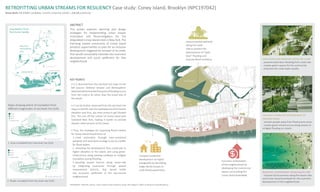
- 1. RETROFITTING URBAN STREAMS FOR RESILIENCY Case study: Coney Island, Brooklyn (NPC197042) Onam Bisht, MLA/MRP candidate, Cornell University (2020) | ob82@cornell.edu ABSTRACT This poster explores planning and design strategies for implementing urban stream restoration and flood-mitigation for the dilapidated Coney Island creek in New York. The low-lying coastal community of Coney Island presents opportunities to plan for an inclusive development triggered by renewal of its creek, that would conceivably translate into economic development and social upliftment for that neighborhood. KEY POINTS • It is observed from the sea-level rise maps on the left (source: National Oceanic and Atomospheric Administration)thatthefirstpointoffloodingoccurs from the creek-si de rather than the ocean-side of the island. • It can be further observed from the sea-level rise mapsontheleft,thattheroadswaysareatthelowest elevation and thus, are most prone to get flooded first. This cuts off the contact of Coney Island with mainland New York, making it harder to provide disaster relief services to the island. • Thus, the strategies for improving flood resiliecy for Coney Island should focus on 1. creek restoration through inter-connected wetlands and sand-dune ecology to act as a buffer for flood-waters. 2. retreating the development from creek-side to higher elevation in the island, and using green- infratructure along existing roadways to mitigate inundation during flooding. 3. boosting coastal tourism along ocean-side by integrating businesses through special improvement districts, that would trickle into economic upliftment of the low-income neighborhood. Compact residential development on higher topography by densifying single-family houses to multi-family apartments. Economic revitalization of the neighborhood by developing the commercial spaces surrounding the Coney Island boardwalk. Interconnected wetlands along the creek- side to prevent the phenomenon of “back- door” flooding and improve flood-resiliency. Interconnected wetlands along the creek - prevents back-door flooding from creek side - creates green spaces for the community - improves the creek water quality Compact residential development on elevated areas - retreats people away from flood-prone areas - creates green-infrastructure along streets to mitigate flooding on streets Economic revitalization along beach-side - improve the businesses along the beach-side and Coney Island boardwalk for the economic development of the neighborhood. Maps showing extent of inundation from different magnitudes of sea-level rise (SLR). 1. Area inundated from Sea-level rise (SLR) Inundation from hurricane Sandy New York metropolitan area Coney Island 2. Roads inundated from Sea-level rise (SLR) REFERENCE: NYCEDC (2013). Coney Island creek resiliency study. NYC Mayor’s office of Recovery and Resiliency. Coney Island creek Calvert-Vaux park Kaiser park Coney Island Beach and Boardwalk Sea Gate Neptune Ave CropseyAve StillwellAve Mermaid Ave Surf Ave