1. TIMMS™
:FAST, ACCURATE &
COST-EFFECTIVE INDOOR MAPPING
Designed for ease-of-use and maneuverability, TIMMS is a
high-productivity tool for accurately measuring, georeferencing
and modeling interior spaces of any size and shape.
capture everything. precisely.
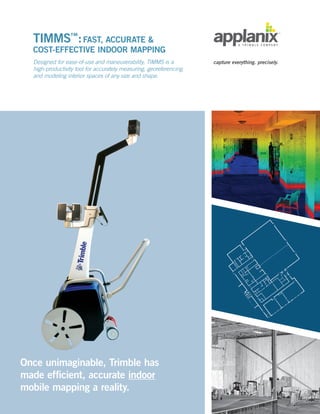
Once unimaginable, Trimble has
made efficient, accurate indoor
mobile mapping a reality.
2. The Trimble Indoor Mobile Mapping Solution (TIMMS)
is the optimal fusion of technologies for capturing spatial
data of indoor and other GNSS-denied areas of all sizes
and locations. It provides both LiDAR and spherical video,
enabling the creation of accurate, real-life representations
(maps, models) of an interior space and all of its contents;
every object in the interior space, including desks, chairs,
stairs, and doors appear in the plan.
TIMMS produces geo-located maps and models – the real
world positions (latitude, longitude, elevation) of each area
of the surveyed building and all of its contents are known.
Because of its high efficiency and speed, TIMMS is very
effective for as-built environments of all sizes, including
very large spaces with multiple rooms (even those
extending over several city blocks). 3D indoor geospatial
views of all kinds of infrastructure can be created:
• Plant and factory facilities
• High-rise office, residential, and government
buildings
• Airports, train stations and other transportation
facilities
• Conference halls, theatres, auditoriums and other
public event spaces
• Covered pedestrian concourses (above and below
ground) with platforms, corridors, stair locations
and ramps
TIMMS is a high-productivity tool for accurately measuring, georeferencing and modeling interior spaces.
TIMMS mobile indoor mapping solution
provides tremendous flexibility in collecting,
accessing, displaying, and analyzing indoor
spatial data. Achieve:
• High accuracy
• High speed collection: Map over
240,000 square feet in a single day
• One data collect, multiple users (address
needs of many with one scan)
• Lower data acquisition cost
• Reduced infringement on operations
• Fast and secure worldwide access to data
Page 2
TIMMS™
:FAST, ACCURATE COST-EFFECTIVE INDOOR MAPPING
3. Page 3 | www.applanix.com
Easily operated and highly
maneuverable, TIMMS
accurately measures and
models interior spaces
without accessing GPS.
TIMMS consists of four core elements:
1. Spherical camera
2. LiDAR engineered to work indoors in
mobile mode
3. Computers and electronics for completing
data acquisition and data processing for
producing final 2D / 3D maps and models
4. Applanix Advanced Positioning System
TIMMS is designed to maximize performance
in the most restricted, confined and difficult-
to-navigate indoor spaces. Designed with the
user in mind, it is very easy to maneuver, lift,
ship, and operate. Whatever your building type
and shape, TIMMS delivers exceptional results,
both in accuracy and ease-of-use.
1
4. Page 4
Why TIMMS?
Fast, Easy, Low-cost: Maximize Your Productivity
With TIMMS a walk-through of an interior space delivers
full 360 degree coverage. Capture and georeference spatial
data in real time. Map thousands of square feet in minutes:
entire buildings in a single day.
Complete, All-In-One Solution
TIMMS includes everything you will need to do indoor
surveys. All hardware and software is specifically designed
and integrated to deliver full indoor mobile mapping
scanning capability quickly and easily. Applanix expert
customer support is also available for every project.
Highly Qualified Applanix Experts Ensure
Your Success
Our experienced team of survey engineers, geospatial
experts, and quality assurance personnel means you get
the highest quality solution and the highest level of
performance. Every Applanix product comes with a
company commitment to world-class support. Applanix
is here to ensure your success.
Tremendous Technical Advantages
• Little or no LiDAR shadowing
• Extended range of operations
• Simple workflow
• Fully customizable
• Data can be utilized with existing
enterprise GIS systems
Cost and Time Savings
In one documented public safety
project in a high school, TIMMS
demonstrated a 50% cost savings
92% reduction in delivery time over
traditional data acquisition methods.
TIMMS scan and resulting
maps/models
5. TIMMS Applications: Turning Data into Decision-Ready Intelligence
Rapid Response / Public Safety / Law Enforcement
Accurate and up to date spatial information of public
buildings offers many safety benefits to responders and
to the public:
• Detailed 360 degree imagery provides responders
with total situational awareness before entering.
Layout and contents are fully known, meaning
no surprises.
• Data is available through the internet behind your
own firewall to multiple decision makers in multiple
locations, enabling informed decisions.
• Data enables detailed preparation and training
for specific buildings / areas.
Commercial Building Management / Space
Utilization / Planning Design
By quickly and accurately determining the current
“as-built” layout and dimensions of existing buildings,
TIMMS delivers critical intelligence for building
management including managing security issues, health
and safety concerns, maintenance, modernization and
restoration planning, and space utilization.
Because of its high efficiency and speed, TIMMS is very
effective for built environments of all sizes, including
very large areas extending over several city blocks
such as malls and underground concourses. This
enables pedestrian traffic planning, retail concession
management, and base mapping for location-based
services of all types.
As-Built Modeling
Increasingly 3D models, 2D floor plans, and Computer
Aided Design (CAD) are being used to increase
productivity in building design, construction, and
maintenance. TIMMS generated interior spatial data –
including building geometry, spatial relationships and
geographic information –facilitates the production of
such models. For Owners/Facility Managers, these jobs
can lead to short and long term operational savings.
6. Page 6
St. Mary’s University College in Calgary was relocated to
the historic Father Lacombe Centre in 1999. The site has
undergone extensive construction and renovation since
then, most recently with the full renovation of the school’s
gymnasium into a brand new athletics centre. The campus
includes several heritage buildings that require ongoing
preservation and documentation.
Building Documentation Needed: The many recent
changes, coupled with the historic nature of the site, meant
that comprehensive and up-to-date plans and blueprints
for most of the buildings simply did not exist. St. Mary’s
required up-to-date building plans that could be used for
campus navigation, safety and emergency planning, and
space allocation.
Solution: InView Solutions, Ltd. used Trimble’s Indoor
Mobile Mapping System (TIMMS) to provide the needed
data. The InView team scanned six major structures on
the St. Mary’s University College Campus in just 20 hours.
From these initial scans, the team created a total of 14 floor
plans to cover all buildings, as well as a full campus virtual
tour. The team later performed a second scan once the
renovations in the new fitness centre were completed.
This dataset was integrated with the original scan to
provide a completely updated model, as well as a before/
after virtual panorama of the facility. The entire process
– from data collection to the production of complete
digital models of the entire campus – took just 55 hours
to complete at a cost saving of over 50% compared to
traditional static methods.
Case Studies
3-Dimensional Indoor Coverage for 50% Less Than Static
Methods at St Mary’s
7. Public Safety: TIMMS Reduces
Cost by More Than 50% and
Time-to-Completion by More
Than 80%
Emergency Planning and Emergency Response are two
important aspects of overall school safety and security,
but both are difficult to act upon without up-to-date and
accurate indoor layout information. Because accurate
blueprints of Northwood-Kensett High School of Worth
County, Iowa were non-existent, first responders were
faced with entering the building “blind” to its structure and
layout, and unsure of where to go and what path to take.
The Challenge: Officials required an easy to use and
highly accurate digital blueprint of the entire school,
with exact distances and measurements of every single
room, closet, hallway and doorway in the structure to
facilitate public safety
The Solution: A simple walk-through with TIMMS of
the school is all it took to achieve full 360 degree indoor
coverage. Georeferenced spatial data was captured
accurately and quickly as the mobile system moved
through the building. Maps and models, covering all
75,000 sq ft in all 90 rooms of the inside of the building,
were created. Scanning took just 5 hours.
Results: Enormous Cost and Time Savings: TIMMS
final product was delivered in 92% less time than static
methods, and the cost of using TIMMS to the school was
50% lower as well.
Page 7 | www.applanix.com
Floor plan created for
Applanix HQ cubicle
TIMMS – 3D LiDAR Based
Model of Philadelphia
Subway Concourse
TIMMS – Spherical
Video of an underground
concourse
The Old Don Jail in Toronto
– All Ceiling Beams/Joists
Observed