Heterogeneity and scale of sustainable development in cities
•
1 like•1,252 views

"Rapid worldwide urbanization is at once the main cause and, potentially, the main solution to global sustainable development challenges.Thegrowthofcitiesistypicallyassociatedwithincreases insocioeconomic productivity, but it alsocreates stronginequalities."

Recommended
Recommended
More Related Content
What's hot
What's hot (19)
Viewers also liked
Viewers also liked (20)
Similar to Heterogeneity and scale of sustainable development in cities
Similar to Heterogeneity and scale of sustainable development in cities (20)
More from Jonathan Dunnemann
More from Jonathan Dunnemann (20)
Recently uploaded
Recently uploaded (20)
Heterogeneity and scale of sustainable development in cities
- 1. Heterogeneity and scale of sustainable development in cities Christa Brelsforda , José Lobob , Joe Handa , and Luís M. A. Bettencourta,1 a Santa Fe Institute, Santa Fe, NM 87501; and b School of Sustainability, Arizona State University, Tempe AZ 85281 Edited by Karen C. Seto, Yale University, New Haven, CT, and accepted by Editorial Board Member B. L. Turner March 21, 2017 (received for review June 24, 2016) Rapid worldwide urbanization is at once the main cause and, potentially, the main solution to global sustainable development challenges. The growth of cities is typically associated with increases in socioeconomic productivity, but it also creates strong inequalities. Despite a growing body of evidence characterizing these heteroge- neities in developed urban areas, not much is known systematically about their most extreme forms in developing cities and their consequences for sustainability. Here, we characterize the general patterns of income and access to services in a large number of developing cities, with an emphasis on an extensive, high-resolution analysis of the urban areas of Brazil and South Africa. We use detailed census data to construct sustainable development indices in hundreds of thousands of neighborhoods and show that their statistics are scale-dependent and point to the critical role of large cities in creating higher average incomes and greater access to services within their national context. We then quantify the general statistical trajectory toward universal basic service provision at different scales to show that it is characterized by varying levels of inequality, with initial increases in access being typically accom- panied by growing disparities over characteristic spatial scales. These results demonstrate how extensions of these methods to other goals and data can be used over time and space to produce a simple but general quantitative assessment of progress toward internationally agreed sustainable development goals. neighborhoods | slums | urban services | spatial correlations | inequality The current worldwide growth of cities presents at once an unprecedented historical opportunity for universal socioeco- nomic development and an immense challenge to global sustain- ability (1, 2). The mechanisms that generate improved living conditions and economic growth in cities—and that typically also increase overall energy and resource consumption—are still only partially understood (1–5) and remain hard to disentangle. Many recent studies have emphasized the environmental and geophysical adverse consequences of an increasing proportion of the planet’s population living in cities and of the acceleration of this transformation in recent decades (6–8). The type and scope of these impacts vary but include air and water pollution, land-cover change, loss of natural habitats, strain on water resources, higher demand for energy, and rising greenhouse gas emissions (1, 8, 9). Conversely, the positive correlation between urbanization and many important dimensions of human development has also be- come increasingly clear. At the national level, the association between higher levels of urbanization and per capita economic productivity has been clear for some time (2). More recently, as city-scale data have become available, evidence has emerged for broader relationships between urbanization and better health, education, longer lifespans, and greater access to basic services, such as water or electricity, at lower nominal costs (2, 10). Regardless of whether the positive or negative outcomes of urbanization are emphasized, a more systematic, empirically based understanding of processes of (sustainable) development is still missing. To fill this gap, we must focus on how and where devel- opment takes place (11): inside cities and in terms of changes experienced by households and neighborhoods (12–14). Initial steps in this direction point to a large heterogeneity and inequality of outcomes between people or places, manifested by the un- precedented scale and growth of vast informal settlements (slums) in low- and middle-income cities (9, 11, 15–17). However, local analysis of change also reveals paths toward more sustainable human development, especially in connection to expanded access to urban services (4, 5, 9, 10, 15, 18), which improve health con- ditions and allow for greater energy and water consumption with much reduced adverse environmental impacts in terms of land use, contaminated effluents, or emissions. The present paper seeks to address this critical need for con- necting processes of change at their sources, by creating a simple framework for the integrated analysis of sustainable development patterns in cities with an emphasis on empirical quantitative measurements across scales—from households to nations—that track progress toward recently agreed sustainable development goals (19). Critical to the understanding and measurement of sustainable development is the construction of empirically based indicators that capture many aspects of the process simultaneously. The Human Development Index (HDI) has been a forerunner of this methodology by emphasizing standards of health and educa- tion in addition to rising incomes (20, 21). Another example is UN-Habitat’s Secure Tenure Index (STI) (9), which characterizes poor (informal) neighborhoods. In both cases, index construction is based upon a capabilities approach to development (22), where high values for indices reflect the attainment of universally de- sirable goals, guaranteeing minimal decent standards of living. This approach is different from and contrasts with the represen- tation of consumption of the same quantities in terms of utility Significance Most nations worldwide have recently committed to solving their most severe challenges of sustainability by 2030, including eradicating extreme poverty and providing universal access to basic services. But how? Rapid urbanization is creating the con- ditions for widespread economic growth and human develop- ment, but its consequences are very uneven. We show how measures of sustainable development—identified by residents of poor neighborhoods—can be combined into a simple and intuitive index. Its analysis reveals that challenges of develop- ment are typically first addressed in large cities but that severe inequalities often result as patterns of spatially segregated rich and poor neighborhoods. A new systematic understanding of these processes is critical for devising policies that produce faster and more equitable universal sustainable development. Author contributions: C.B., J.L., and L.M.A.B. designed research; C.B. and L.M.A.B. per- formed research; C.B., J.L., J.H., and L.M.A.B. contributed new reagents/analytic tools; C.B. and L.M.A.B. analyzed data; and C.B., J.L., and L.M.A.B. wrote the paper. The authors declare no conflict of interest. This article is a PNAS Direct Submission. K.C.S. is a guest editor invited by the Editorial Board. Data deposition: All data are available at www.santafe.edu/∼bettencourt/heterogeneity- scale-sustainable-development. 1 To whom correspondence should be addressed. Email: bettencourt@santafe.edu. This article contains supporting information online at www.pnas.org/lookup/suppl/doi:10. 1073/pnas.1606033114/-/DCSupplemental. www.pnas.org/cgi/doi/10.1073/pnas.1606033114 PNAS Early Edition | 1 of 6 SUSTAINABILITY SCIENCE SPECIALFEATURE
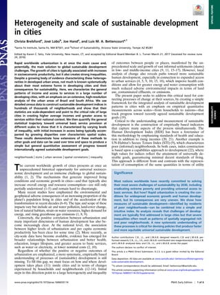
- 2. functions common in economic modeling, which requires as- sumptions about individual-level behaviors and preferences. Our approach below parallels the development of the HDI and STI toward assessing the universal attainment of broad development goals in cities (19). A critical problem in any assessment of development is tied to inequality (14). Average quantities over large populations, such as nations or metropolitan areas (MAs), hide extremes (18, 23). Depending on our understanding of these processes and the scale at which they are measured, proposed solutions may take different forms. Specifically, during the transition between extreme poverty and total absence of services to greater affluence and widespread provision of basic needs the creation of extreme inequalities is common (24, 25). Thus, any intervention is likely to affect distinct groups in different ways, an issue often described in terms of distributional effects (SI Appendix). The distributional effects lit- erature makes it clear that impacts are more varied than they seem when evaluated by averages (26) and that policies that target av- erage effects risk producing unintended consequences that are often regressive, placing disproportionate burdens on disadvan- taged populations (27). To identify these issues, we will introduce simple ways to measure and assess distributional effects via the statistical analysis of sustainable development indices. We illustrate our approach through the analysis of detailed data from Brazil and South Africa to characterize three fun- damental aspects of sustainable development in cities. First, we ask whether there is a general relationship, and expected feedbacks, between agglomeration effects associated with higher economic productivity in larger cities and improving living conditions. Second, we ask whether there are general quantitative sustainable development paths for units of analysis at different scales (neighborhoods to nations), characterized not only by averages but also by associated levels of heteroge- neity. Finally, we assess the importance of space and specifi- cally ask what sets the scale for the observed socioeconomic heterogeneity within cities. Results We now provide a detailed spatial and socioeconomic character- ization of development patterns in a range of low- and middle- income cities. Fig. 1A gives a first impression by showing a map of South Africa highlighting its large cities (MAs), each consisting of hundreds of neighborhoods (see also SI Appendix, Figs. S1–S8). Measuring any sustainable development characteristic at different scales results in different levels of heterogeneity expressed by measures of inequality such as the Gini index, which is typically larger at the metropolitan level but smaller within neighborhoods (Fig. 1B and SI Appendix, Figs. S9–S11). To better understand how sustainable development takes place in cities, we start by sum- marizing results from recent neighborhood surveys expressing slum dwellers’ self-identified development priorities followed by an analysis of agglomeration effects in income and provision of the same priorities using detailed data from MAs of Brazil and South Africa. We conclude by analyzing how these patterns change across different scales of analysis, emphasizing the connections between heterogeneity, inequality, and spatial structure. Neighborhood Priorities in Developing Cities. Slums constitute a substantial fraction of all neighborhoods in cities of South and Southeast Asia and in sub-Saharan Africa (9) and illustrate the access to electricity sanitation water housing quality income education Greater Johannesburg Sustainable Development Indicators { Slum Development PrioritiesGini for Income GiniCoefficient Sustainable Development Index 0.20.40.60.81 housing water & drainage sanitation & sewage land tenure electricity housing electricity road land tenure transport garbage water & drainage health other sanitation & sewage educationCountry Province District Municipality Main Place Sub Place No Data 0 – 0.25 (Low Services) 0.25 – 0.5 0.5 – 0.9 0.9 – 0.95 0.95 – 0.99 0.99 – 1 (Full Services) A B C Fig. 1. Heterogeneity and scale of sustainable development in cities. (A) The Sustainable Development Index, Xi, at the subplace level for all of South Africa, the Johannesburg MA, and a single subplace. (B) The values of the Gini coefficient for income across scales for South Africa. The median across all units of analysis within a class is shown by a horizontal black line, with the 25th to 75th percentiles shown by the gray box. (C) Development priorities identified by slum residents in the 10 countries in Table 1. 2 of 6 | www.pnas.org/cgi/doi/10.1073/pnas.1606033114 Brelsford et al.
- 3. direst challenges of urban sustainable development. World- wide one in seven people is presently estimated to live in slums, but this number rises to one in two or more in parts of South Asia and Africa (2, 9). International development agencies have stressed the critical need for better un- derstanding the nature of human and economic development in these poor neighborhoods, and of acquiring detailed em- pirical information on their primary needs and priorities (2, 9). However, extensive direct information on residents’ pri- orities is still rare. Recent efforts provide us with some new insights on the most important development needs expressed by slum residents (15, 28). Table 1 and Fig. 1C show residents’ priorities in 677 neighborhoods in 10 nations and 59 cities mostly in low-income nations in sub-Saharan Africa (Materials and Methods and SI Appendix, Fig. S12). Most of these data pertain to large and fast-growing urban areas, such as Lagos, Nairobi, Dar-es-Salam, Kampala, Blantyre, Freetown, Johan- nesburg, Cape Town, or Windhoek. Although there is broad agreement on the most important priorities, there are also a number of differences across nations (and cities). Overall, water and drainage is the most frequent problem, mentioned 36.9% of the time, followed by issues of housing (21.3%), sanitation and sewage (13.9%), land tenure (13.7%), and electricity (6.2%). These priorities emphasize the dual role of basic services and improved housing in promoting the resilience of communities against both chronic stresses and extreme events, such as flooding and diseases associated with local environmental degradation (15, 29). Other issues, related to health access, transportation, waste collection, jobs, and educa- tion, also come up frequently but are stated as less critical. Apart from land tenure, all other issues deal with daily living challenges and are intimately connected to access to improved basic services and local environmental conditions. These findings resonate with recent definitions of sustainable development (9, 29) to which we now turn using extensive neighborhood data from two large middle-income nations: Brazil and South Africa. City Size and Agglomeration Effects. Agglomeration effects are at the root of the advantages of larger cities at creating greater resources per capita, which historically have led to innovation and development along a broad range of human and environmental issues (2, 30, 31). Cities are characterized by two general phe- nomena: agglomeration effects and high socioeconomic and spa- tial heterogeneity (32–35). Both have long been understood as having a strong scale (population size) dependence (36). The strength of these scaling effects and the nature of urban hetero- geneity have, however, remained poorly studied in rapidly de- veloping cities, in large part due to the absence of systematic data for appropriate units of analysis. Scaling effects are expressed in terms of the mean expected values for urban quantities, such as the size of the overall economy (gross domestic product, GDP), personal income, amounts of in- frastructure, rates of innovation, and so on, as functions of city population size (31, 34, 35). Nonlinear scaling of all these quanti- ties is predicted for functional cities, defined as spatially embedded networks of socioeconomic interaction (35, 37), known as MAs. MAs are integrated labor markets circumscribing areas of work and residence for most of their inhabitants. For other definitions of cities, whether political or resulting from density thresholds, ag- glomeration effects may vanish or seem inconsistent, possibly be- cause not all heterogeneity is included (38, 39). To illustrate these effects, Fig. 2A shows total income for MAs in South Africa and Brazil, versus their population size (see also Table 2). In Brazil, MAs typically include many (political) mu- nicipalities, whereas in South Africa they are made up of a single large municipality, with the exception of Greater Johannesburg (SI Appendix, Figs. S1–S5 and Table 2). Table 1. Summary of slum development priorities Nations Priorities Total South Africa, % Tanzania, % Kenya, % Uganda, % Malawi, % Namibia, % Sierra Leone, % Nigeria, % All 677 26.90 26.70 22.20 13.10 4.40 2.70 1.60 1.50 Water and drainage 36.90% 20.30 43.50 33.30 57.30 76.70 11.10 81.80 10.00 Housing 21.30% 44.00 2.80 32.00 5.60 0 11.10 0 10.00 Sanitation and sewage 13.90% 8.20 14.90 10.70 27.00 16.70 27.80 0 0 Land tenure 13.70% 18.70 4.40 21.30 4.50 3.33 33.30 9.10 60.00 Electricity 6.20% 8.20 8.30 1.30 4.50 0 16.70 0 20.00 Others 7.80% 0.50 27.10 1.30 1.10 0 0 9.10 0.00 There are 10 nations and 59 cities in the dataset. Four neighborhoods in the Philippines and two in Ghana are not shown but are included in the totals. -1-.50.51 -.15 -.1 -.05 0 .05 .1 0.1.2.3.4.5 0 .25 .5 .75 1 σXi service mean Xi service LogPersonalIncome Log Metropolitan Population Moran’sIforXi b residuals σXi mean Xi Manguang Nelson Mandela Cape Town Buffalo City eThekwini Ekhurleni Tshwane Jo’Burg S. African Cities Brazilian Cities Boundary Line S. African Best Fit Brazilian Best Fit 0.1.2.3.4.5 X 0 .25 .5 .75 1 Electricity Water Sanitation Homes Electricity Sanitation Water Homes 5 km 15 km 00.5 A B DC Fig. 2. Agglomeration effects and heterogeneity of sustainable develop- ment in cities of Brazil and South Africa. (A) Scaling of personal income with population for Brazil (squares) and South Africa’s MAs (triangles). The yellow line shows the theoretical slope of 1 + 1/6 (35), the red shows the best fit, and the gray line shows the 1:1 line for reference. The best fit demonstrates that larger cities have on average higher resources per capita, at least in nominal terms, which can be invested in sustainable development. (B) The relationship between the SD, σi, and mean, Xi, of the Sustainable Develop- ment Index, Xi, for Brazil’s 38 MAs (purple) and 207 South African municipal regions (orange), where the size of the circle is proportional to population. The two black lines bind the area in which (Xi, σi) pairs can exist, with the upper curved line showing maximal inequality (Kuznets curve, b = 1) and the horizontal line corresponding to total equality (b = 0). The dashed line shows the estimated best fit for the mean heterogeneity index b. (C) The de- composition of Xi into subcomponents: Xi electricity (orange), Xi water (blue), Xi sanitation (green), and Xi homes (purple) for Brazil’s metropolitan regions, which allows us to see the role of larger cities at providing improved services. (D) The positive association between Moran’s I (distance threshold = 5km) and σi for South African municipalities, showing that higher spatial cluster- ing is associated with higher inequality of access to services. (Inset) The variation of Moran’s I with the distance threshold s for South Africa’s major metropolitan regions. Brelsford et al. PNAS Early Edition | 3 of 6 SUSTAINABILITY SCIENCE SPECIALFEATURE
- 4. As in many other urban systems, total personal income, Yj, for each urban area, j, is well described statistically by a scale-free function of the form Yj = Y0Nβ j eξj , [1] where the prefactor, Y0, is independent of city population size, Nj, and where β is a scaling exponent (or elasticity: β = dlnY/dlnN). The quantities ξj are (scale-independent) deviations from the mean (scaling) expectation and are characterized by a zero mean and a small variance. Fig. 2A and Table 2 show the scaling results for the two nations as well as their combined behavior (after centering the regression and pooling the data; see ref. 37). The scaling exponent β = 1.11 estimated for Brazil is very similar to that of the United States and to the GDP of Brazilian MAs (35). The relatively large number of MAs in Brazil and their size range allows us to establish with high confidence that this result is broadly consistent with theory (35), which derives quantitative expectations for scaling exponents from calculating rates of socio- economic interactions for a population in a spatial steady state, determined by the balance of benefits and transportation costs in the tradition of urban economic geography (37). The smaller num- ber of South African MAs show stronger scaling effects with a larger β = 1.35 but also with a wider confidence interval. The combined dataset, Fig. 2A, shows scaling that is statistically indis- tinguishable from the simplest prediction of urban scaling theory, β = 7/6 (35), shown as a yellow line in Fig. 2A. A consequence of this scaling behavior is that larger cities have greater average incomes per capita and thus may exhibit greater capacity to dedicate more resources to services and infrastructure (34–36, 40). Such allocations may happen directly via local taxes or indirectly via higher receipts and reinvestments managed at the national level (30). To investigate this issue empirically, we define a sustainable development index, Xi, characterizing a population in a given spatial unit of analysis i, as Xi = ffiffiffiffiffiffiffiffiffiffiffiffi Yn j=1 Xj i n v u u t . [2] This index spans a number of dimensions n of sustainable devel- opment. Because much of the underlying data for assessing sus- tainable development goals (SDGs) remain to be collected, we illustrate here its properties in terms of access to basic services and housing (SDG goals 6, 7, 11; or 4 of the STI’s components): Xi = h Xwater i Xelectricity i Xsanitation i Xhomes i i1=4 , [3] where Xwater i is the fraction of the population in unit i with access to an improved water source. Similarly the superscripts electricity, sanitation, and homes refer to access to electrical power, im- proved sanitation, and permanent housing. Descriptions and emerging international standards for their use as indicators are given in Materials and Methods and SI Appendix. This index is bounded between Xi = 0, when one or more services are totally absent, and Xi = 1, when there is universal access within area i. The multiplicative character of the index follows the con- struction of the HDI and emphasizes that all components are es- sential for achieving a set level of development (41) and are not substitutable. This form is also consistent with the HDI (20, 21) and UN-Habitat’s definition of a “slum household” as a household that lacks access to any one of these services in the composite STI (9). For purposes of illustration, we show in SI Appendix, Figs. S13–S16 and section 1.5 the comparison between the multiplicative and additive forms of X and refer the reader to the relevant discussions leading to changes in the definition of the HDI to a multiplicative form, which motivate Eq. 2 (20, 21). Fig. 2B shows the average value of Xi for urban areas of different population sizes in Brazil and South Africa. In general, the level of services increases with city size (SI Appendix, Figs. S17 and S18), a trend that is especially clear in South Africa. In some parts of Brazil, service provision has expanded more systematically to smaller cities and rural areas (SI Appendix, Fig. S8). These results answer our first question: The relative performance of larger cities in terms of access to services and thus some of the dimensions of sustainable develop- ment is consistent with advantages derived from urban agglomeration effects and points to a wide range of reasons why urbanization con- tinues to grow in low- and middle-income nations beyond strictly economic motives. As SI Appendix, Figs. S17 and S18 show, living in larger cities means that, on average, residents obtain access to many dimensions of sustainable development sooner. However, these av- erages hide large heterogeneities, to which we now turn. Heterogeneity of Development Across Scales. Measures of hetero- geneity within MAs are especially important because at this scale residents share the same labor and real-estate markets and thus face many of the same opportunities and costs (35, 42). Measures of heterogeneity may be spatially explicit or they may consider only variation within a population. The Gini coefficient (Fig. 1B and SI Appendix, Figs. S9–S11) is a well-known nonspatial measure of heterogeneity. A simpler measure of variation is the SD, σ, and its relation to the mean of any socioeconomic variable. Moran’s I, by contrast, is the most widely used measure of spatial heterogeneity (43): It accounts for the level of correlation between characteristics at two spatial locations separated by a distance. The Gini coefficient (or the SD) and Moran’s I are not necessarily correlated because this depends on the spatial structure of mixing between different people. Any resource within a population may be spatially distributed in a manner that is maximally clustered, meaning that Moran’s I approaches I = 1, or perfectly anticorrelated (like a checkerboard), so that Moran’s I approaches I = −1, or a random (well-mixed) pattern, when Moran’s I approaches I = 0 (see SI Appendix, Figs. S19 and S20 for illustrations). Table 2. Agglomeration and heterogeneity of sustainable development indicators Summary statistics MAs N_units Estimate 95% CI Fit Brazil (metros) Income exponent β 39 1.11 [1.03, 1.20] R2 = 0.90 Heterogeneity index b 38 0.58 [0.56, 0.60] R2 = 0.99 South Africa Income exponent (metros) β* 8 1.35 [1.19, 1.53] R2 = 0.97 Heterogeneity index (municipalities) b 207 0.57 [0.54, 0.60] R2 = 0.96 *The scaling fit without aggregation of the three municipalities in the Johannesburg area gives β = 1.49, with 95% CI [1.17, 1.81], R2 = 0.87. The best fit for the combined dataset after centering is β = 1.14, 95% CI [1.06, 1.23], R2 = 0.89, statistically indistinguishable from the simplest theoretical expectations (yellow line) in Fig. 2A. One MA in Brazil was excluded from b’s estimate because of data completeness issues. 4 of 6 | www.pnas.org/cgi/doi/10.1073/pnas.1606033114 Brelsford et al.
- 5. These quantities, taken together, characterize the heterogeneity of sustainable development indices in cities. From its definition, we see that the variance of X must be a function of the mean, and vanish when everyone in unit i has services, X = 1, or when they are nonexistent, X = 0. It typically is maximal when the mean X= 1/2, because then there are more configurations possible, for example by having households with different levels of access within and across neighborhoods i. Thus, we can parameterize the SD of Xi, σi, as σi = bi ffiffiffiffiffiffiffiffiffiffiffiffiffiffiffiffiffiffiffiffiffiffi Xi À 1 − Xi Áq , [4] where the square root corresponds to the SD of a random Bernoulli process. This relation means that b = 1 gives the maximal variance at each value of the average X(Fig. 2 B and C). Note also that it follows from the properties of the SD that b ≥ 0. Thus, we can characterize two-dimensional trajectories in the space of (Xi, σi) as levels of development change in each unit, i, and the values of (Xi, σi) → (1,0). Given Xi, these trajectories are charac- terized by a single number: the value of bi as a function of place and time. There are two special trajectories—of maximal and minimal heterogeneity—characterized by bi = 1 and bi = 0, respectively, indicated in Fig. 2 B and C by solid black lines. Because of these properties we refer to bi as a (normalized) heterogeneity index. Although our present data are cross-sectional, we can compare different urban areas by estimating levels of heterogeneity in terms of b. Fig. 2B shows the plot of X versus σ for Brazilian MAs and South African municipalities (see also SI Appendix, Figs. S21 and S22). Across different urban areas, we observe a Kusnetz-curve type behavior (24), where intermediate levels of access are asso- ciated with the greatest variance. We estimated the values of b (SI Appendix, Figs. S21–S23) to determine the expected value of b = 0.58 for Brazil and b = 0.57 for South Africa, which are statistically indistinguishable from each other (Table 2). The frequency of residuals (SI Appendix, Figs. S24 and S25) shows that the variation of b across different cities is small and slightly left-skewed so that trajectories with considerably lower inequality are possible. It is also important to realize that levels of heterogeneity are scale- dependent, as shown in Fig. 1B. Adopting smaller units of analy- sis, such as neighborhoods, obtains lower values of b. These results answer our second question: They suggest that there are generic trajectories of local development (Fig. 2 B and C). Empirically, the variation between neighborhoods is closer to the case where access is distributed in an all-or-nothing manner (b → 1) rather than when access, though limited, is provided equally to everyone (b → 0Þ. These results provide a set of specific expectations for local urban development as longitudinal data become available. To explicitly take into account the effects of space, we now use Moran’s I to measure the similarity of conditions between nearby neighborhoods (SI Appendix, Figs. S19 and S20 and Materials and Methods). We varied the distance between neighborhoods to measure the corresponding strength of spatial correlation for various quantities (Fig. 2D, Inset, SI Appendix, Fig. S26, and Table 2). In all cases, we find clear evidence of strong spatial clustering in access to services with a magnitude that is strongest at a “walkable” distance below a few kilometers (Fig. 2D, Inset). This spatial correlation is even higher for socioeconomic quantities, such as income and racial composition (SI Appendix, Fig. S26). These results suggest that assortative dy- namics, which generate strong spatial economic and racial inequalities in US cities (25, 33), are likely also at play in urban areas of Brazil and South Africa. Higher levels of spatial clustering, measured by the magnitude of I, are also statistically associated with higher levels of heterogeneity in access to services, measured via the magnitude of b (Fig. 2D). These findings answer our final question: Heterogeneity between people is expressed spatially as differences between places within a city defined at about a kilometer scale, rather than differences within spatially well-mixed populations. In other words, heterogeneity is expressed in these cities systematically as spatially concentrated (dis) advantage (14, 25, 33). Discussion and Outlook We have shown how several central features of sustainable develop- ment are intimately connected to agglomeration and heterogeneity effects in cities and how the scale of spatial units of analyses matters to measure inequality and inform more effective assessments and policy. We expressed these connections in terms of three general questions, which we answered through empirical analysis using data from Brazil and South Africa. First, we have demonstrated that despite environ- mental challenges larger cities tend to exhibit greater economic pro- ductivity and expanded access to housing and urban services (2), which nucleate solutions for sustainable development within their nations. Second, large inequality typically results as improvements are initially expanded (15). Such patterns of inequality are scale- dependent, being larger between different neighborhoods within MAs. Nevertheless, high levels of inequality are not in- evitable and several places offer counterexamples of develop- ment with low inequality. Importantly, we observe that stronger heterogeneities are associated with more spatially concentrated outcomes at characteristic scales of about a kilometer. The indicators and statistical analyses introduced here provide a general roadmap for better understanding and assessing sustainable development in cities across scales. The construction of the sustainable development index Xi is general and should be improved and ex- panded to additional sustainability measures as data become available, for example relating to access to education, gender equity, health, clean energy, and environmental quality, measured within cities and globally. To this end, it is important to emphasize several shortcomings of present data, which we expect will be gradually overcome in the near future. First, our analysis was focused on neighborhoods and cities of Brazil and South Africa, two middle-income nations with well- established urban systems and state-of-the-art census practices (SI Appendix). Other cities in lower-income nations may show much more incipient processes of sustainable development (9, 15, 29). It will be critical to identify and track such situations over time. Second, local sustainability indicators must be expanded to include associated quality of service. Measures associated with safety, health, environ- mental impacts, effort allocation, and pecuniary costs will need to be better factored in so as to promote meaningful progress (15, 29). This approach requires measurements of the several components, Xj i, that are closer to the experience of individuals and to the spirit of each development goal and should mirror the process by which components of the HDI have been improved over time in contact with a growing availability of data and case studies (20, 21). A third area of concern is time. We used census data for Brazil and South Africa because they are consistent and well-documented and cover every neighborhood in these large nations. However, these are decennial census data, and 10 years is too long to assess change in fast-growing MAs given the timeline to meet sustainable development goals. Two new sources of such data may come from remote sensing and citizen-generated maps and surveys. More-frequent and higher- resolution imagery may help identify the type and quality of housing and physical infrastructure and track new construction (44–46). Working collaborations between local governments, communities, and civic organizations using new data collection, mapping, and reporting technologies will be essential to create detailed evidence that is accurate, verifiable, and expressive of residents’ priorities (47, 48). These collaborations also generate possibilities for supporting training and education, while providing a mechanism for local knowledge and experiences to guide change (15, 28, 47, 48). The ultimate objective of a scientific understanding of sustain- able development is to decouple improving living standards from environmental degradation. Cities play a crucial role in both processes (2, 4–6, 9, 15, 30). They create increased socioeconomic productivity and a greater intensity of environmental impacts in ways that are at once connected but also place- and scale- dependent (9, 14, 29). As emphasized by the evidence docu- mented here, the continued improvement of theory and practices that exploit the joint dynamics created by scaling effects, hetero- geneity, and spatial structure across a large number of socioeco- nomic and physical dimensions will be critical for harnessing the Brelsford et al. PNAS Early Edition | 5 of 6 SUSTAINABILITY SCIENCE SPECIALFEATURE
- 6. transformative power of cities toward faster and more equitable processes of socioeconomic and environmental change. Materials and Methods Development Priorities Surveys. Data on informal settlement development pri- orities were extracted from “informal settlement profiles”—neighborhood surveys of population and services (28)—conducted during 2014–2015 by Slum/Shack Dwellers International (knowyourcity.info/) national federations in collaboration with neighborhood communities and our group. Table 1 derives from 677 neigh- borhood profiles in 10 nations and 59 cities, including 4 neighborhoods in the Philippines and 2 in Ghana, which are included in the total data but not as indi- vidual countries. Among other questions, communities were asked to discuss and identify their most pressing needs in ranked order. The data shown refer to their highest self-identified priority. Small Area Statistics Data for Brazil. Data for small area statistics in Brazil were obtained from the 2010 national census, available at www.ibge.gov.br. The data are provided in a hierarchical set of spatial units (SI Appendix, Fig. S6). The base unit of analysis is the setor (average population = 695), modeled after US census tracts. The municipality and the metropolitan region are the geographic levels at which we report statistics. There are currently 39 metropolitan regions in Brazil, made of sets of municipalities ranging in population from about 1/4 to almost 20 million (São Paulo). There are 121,030 urban setores in Brazil, characterized in the main text and SI Appendix. Data contain detailed information on demographic and household characteristics in addition to construction and access to services. Neighborhood Statistics for South Africa. South African neighborhood data are drawn from the 2001 national census, available at www.statssa.gov.za. South Africa produces universal coverage census data relevant for assessing sustainable development indicators reported in small geographical units, called “sub- places” (average population = 2,100; median population = 770). We report statistics on municipalities, defined by Statistics South Africa, which also designates eight functional cities as metropolitan municipalities (SI Appendix, Figs. S1–S5). The contiguous metropolitan municipalities of Johannesburg and Ekurhuleni (East Rand) are often aggregated into a single large urban area of Greater Johannesburg, and there is discussion as to whether Tshwane (Pre- toria), with a city center 35 km away, should also be included. Sustainability Index Definition. Indices accounting for the degree of attaining each development goal were constructed for the smallest units of analysis (setor in Brazil, and subplace in South Africa) and composed multiplicatively (Eq. 2) to generate a composite index. Measures of access to each service category follow the definitions developed by the Joint Monitoring Program and UN-Habitat; see Satterthwaite (29) and SI Appendix, section 1.3 for additional details. Scaling Analysis. Scaling parameter estimation was performed using ordinary least-squares regression of logarithmically transformed variables. Fig. 2A shows centered data, obtained by subtracting the average logarithmically transformed population and income (see ref. 39). Heterogeneity Analysis. Estimates of the heterogeneity index b were obtained from Eq. 4, given the estimated mean and SD of X or Xservice for each spatial unit i. Moran’s I estimates were obtained using the smallest available units (setor or subplace). A matrix of nearest neighbors j, wij for each neighborhood i was constructed as wij = 1/dij, cut off at distance s, which is varied to explore the strength of I (Fig. 2D, Inset). ACKNOWLEDGMENTS. We thank Anni Beukes and members of Slum Dwellers International for discussions and use of informal settlement profiles data, and the Arizona State University/Santa Fe Institute Center for Biosocial Complex Systems for partial support. This work was partially funded by MacArthur Foundation Grant 13-105749-000-USP and Army Research Office Minerva Program Grant W911NF1210097. 1. Montgomery MR (2008) The urban transformation of the developing world. Science 319:761–764. 2. UN-Habitat (2012) State of the World’s Cities 2012/2013, Prosperity of Cities. Available at mirror.unhabitat.org/pmss/listItemDetails.aspx?publicationID=3387. 3. Solecki W, Seto KC, Marcotullio PJ (2013) It’s time for an urbanization science. Environ Sci Policy Sustain Dev 55:12–17. 4. Bettencourt L, West G (2010) A unified theory of urban living. Nature 467:912–913. 5. Kennedy CM (2011) The Evolution of Great World Cities: Urban Wealth and Economic Growth (Univ of Toronto Press, Toronto). 6. Turner BL, ed (1990) The Earth As Transformed by Human Action (Cambridge Univ Press, New York). 7. Seto KC, et al. (2012) Urban land teleconnections and sustainability. Proc Natl Acad Sci USA 109:7687–7692. 8. Mundia CN, Aniya M (2006) Dynamics of landuse/cover changes and degradation of Nairobi City, Kenya. Land Degrad Dev 17:97–108. 9. UN-Habitat (2003) The Challenge of Slums: Global Report on Human Settlements. Available at mirror.unhabitat.org/pmss/listItemDetails.aspx?publicationID=1156. 10. Lozano-Gracia N, et al. (2013) Urbanization beyond municipal boundaries: Nurturing metropolitan economies and connecting peri-urban areas in India (English). Available at documents.worldbank.org/curated/en/373731468268485378/Urbanization-beyond-municipal- boundaries-nurturing-metropolitan-economies-and-connecting-peri-urban-areas-in-India. 11. Bolay J-C (2006) Slums and urban development: Questions on society and global- isation. Eur J Dev Res 18:284–298. 12. Bloom DE, Canning D, Fink G (2008) Urbanization and the wealth of nations. Science 319:772–775. 13. O’Hara SU (2001) Urban development revisited: The role of neighborhood needs and local participation in urban revitalization. Rev Soc Econ 59:23–43. 14. Robert J Sampson (January 6, 2017) Urban sustainability in an age of enduring in- equalities: Advancing theory and ecometrics for the 21st-century city. Proc Natl Acad Sci USA, 10.1073/pnas.1614433114. 15. Mitlin D, Satterthwaite D (2013) Urban Poverty in the Global South: Scale and Nature (Routledge, New York). 16. Marx B, Stoker T, Suri T (2013) The economics of slums in the developing world. J Econ Perspect 27:187–210. 17. Glaeser EL (2014) A world of cities: The causes and consequences of urbanization in poorer countries. J Eur Econ Assoc 12:1154–1199. 18. Baker JL (2008) Urban poverty: A global view. Available at documents.worldbank.org/ curated/en/954511468315832363/Urban-poverty-a-global-view. 19. United Nations (2015) Sustainable development goals. Available at https://sustaina- bledevelopment.un.org/. 20. Stanton EA (2007) The human development index: A history. Available at https:// ideas.repec.org/p/uma/periwp/wp127.html. 21. Herrero C, Martínez R, Villar A (2010) Multidimensional social evaluation: An appli- cation to the measurement of human development. Rev Income Wealth 56:483–497. 22. Sen A (2008) Commodities and Capabilities (Oxford Univ Press, New Delhi). 23. Crane R, Daniere A (1996) Measuring access to basic services in global cities: De- scriptive and behavioral approaches. J Am Plann Assoc 62:203–221. 24. Kuznets S (1955) Economic growth and income inequality. Am Econ Rev 45:1–28. 25. Reardon SF, Bischoff K (2011) Income inequality and income segregation. AJS 116:1092–1153. 26. Bitler MP, Gelbach JB, Hoynes HW (2006) What mean impacts miss: Distributional effects of welfare reform experiments. Am Econ Rev 96:988–1012. 27. Parry IWH (2004) Are emissions permits regressive? J Environ Econ Manage 47:364–387. 28. Patel S, Baptist C, D’Cruz C (2012) Knowledge is power – Informal communities assert their right to the city through SDI and community-led enumerations. Environ Urban 24:13–26. 29. Satterthwaite D (2016) Missing the Millennium Development Goal targets for water and sanitation in urban areas. Environ Urban 28:0956247816628435. 30. Mumford L (1961) The City in History: Its Origins, Its Transformations, and Its Prospects (Harcourt Brace Jovanovich, New York). 31. Rosenthal SS, Strange WC (2004) Evidence on the nature and sources of agglomera- tion economies. Handbook of Regional and Urban Economics, eds Henderson JV, Thisse J-F (Elsevier, Amsterdam), Vol 4, pp 2119–2171. 32. Wirth L (1938) Urbanism as a way of life. Am J Sociol 44:1–24. 33. Sampson RJ (2012) Great American City: Chicago and the Enduring Neighborhood Effect (Univ of Chicago Press, Chicago). 34. Bettencourt LMA, Lobo J, Helbing D, Kühnert C, West GB (2007) Growth, innovation, scaling, and the pace of life in cities. Proc Natl Acad Sci USA 104:7301–7306. 35. Bettencourt LMA (2013) The origins of scaling in cities. Science 340:1438–1441. 36. Henderson JV (1991) Urban Development: Theory, Fact, and Illusion (Oxford Univ. Press, New York). 37. Alonso W (1977) Location and Land Use: Toward a General Theory of Land Rent (Harvard Univ Press, Cambridge, MA). 38. Arcaute E, et al. (2015) Constructing cities, deconstructing scaling laws. J R Soc Interface 12:20140745. 39. Bettencourt LMA, Lobo J (2016) Urban scaling in Europe. J R Soc Interface 13:20160005. 40. Hoch I (1972) Income and city size. Urban Stud 9:299–328. 41. United Nations Development Programme (2013) 2013 Human Development Report. Available at hdr.undp.org/en/2013-report. 42. Glaeser EL, Scheinkman J, Shleifer A (1995) Economic growth in a cross-section of cities. J Monet Econ 36:117–143. 43. Anselin L (2013) Spatial Econometrics: Methods and Models (Springer, Dordrecht, The Netherlands). 44. Wentz E, et al. (2014) Supporting global environmental change research: A review of trends and knowledge gaps in urban remote sensing. Remote Sens 6:3879–3905. 45. Brook A, Ben-Dor E, Richter R (2013) Modelling and monitoring urban built environment via multi-source integrated and fused remote sensing data. Int J Image Data Fusion 4:2–32. 46. Hoalst-Pullen N, Patterson MW (2011) Applications and trends of remote sensing in professional urban planning: Remote sensing in professional urban planning. Geogr Compass 5:249–261. 47. Ostrom E (1996) Crossing the great divide: Coproduction, synergy, and development. World Dev 24:1073–1087. 48. Mabogunje AL (2007) Tackling the African “poverty trap”: The Ijebu-Ode experiment. Proc Natl Acad Sci USA 104:16781–16786. 6 of 6 | www.pnas.org/cgi/doi/10.1073/pnas.1606033114 Brelsford et al.