More than Just Lines on a Map: Best Practices for U.S Bike Routes
Harappan
1. New Insights into Harappan Town-Planning, Proportions and Units,
with Special Reference to Dholavira*
Michel Danino
80 Swarnambika Layout, Ramnagar
Coimbatore 641 009 Tamil Nadu
Email: michel_danino@yahoo.com
(Paper published in Man and Environment, vol. XXXIII, No. 1, 2008, pp. 66-79)
Abstract
Dholavira’s elaborate town-planning rests on the conscious use of specific
proportions for its successive enclosures. Those proportions combined with the
city’s dimensions allow us to calculate precisely the unit of length used for the
fortifications, to relate it to the Lothal ivory scale, and to work out potential
subunits. Both proportions and units receive overwhelming confirmation from
structures of Dholavira and other Harappan sites. Units are finally refined to a
dhanus of 190.1 cm and an angula of 1.76 cm, the former being 108 times the latter.
The Dholavirian scheme of units is then shown to be related to historical unit
systems in several ways; in particular, the Arthashastra’s scheme of linear measures
conclusively has Harappan roots. Finally, the paper attempts to outline some of the
abstract concepts underlying Dholavira’s geometry, taking a peep at a hitherto
neglected component of the Harappan mind.
Dholavira’s Ratios
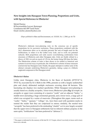
Unlike most Harappan cities, Dholavira in the Rann of Kachchh (23°53’10” N,
70°13’ E), excavated by R. S. Bisht in the 1990s, presents us with a largely undisturbed
plan and clearly delineated multiple enclosures covering about 48 hectares. This
fascinating site displays two marked specificities. While Harappan town-planning is
usually based on a duality acropolis / lower town, Dholavira’s plan (Fig. 1) is triple: an
acropolis or upper town consisting of a massive “castle” and an adjacent “bailey,” a
middle town (including a huge ceremonial ground), and a lower town, a large part of
which was occupied by a series of reservoirs. (Throughout this paper, terms such as
“castle,” “bailey,” “granary,” “college,” etc., have been used with quotation marks to
remind the reader that they are conjectural in nature; similarly, the neutral term
“acropolis” has been preferred to the misleading “citadel,” as it is now largely accepted
that the upper town in Harappan settlements had no inherent military purpose; in the
same spirit, “fortifications” has been preferred to “defences.”)
* This paper is dedicated to the memory of the late Dr. S. P. Gupta, whom I was lucky to know and to learn
from over a decade.
2. New Insights into Harappan Town-Planning, Proportions and Units / p. 2
Fig. 1. Plan of Dholavira (adapted from Bisht 1999)
Table 1 summarizes the city’s dimensions, as supplied by the excavator (Bisht 1997,
1999, 2000), with a maximum margin of error of 0.5% (Bisht 2000: 18). Because these
figures are our primary data on which all further calculations of margins of error will
depend, they have not been rounded off and are quoted as published.
Dimension Measurement (in metres)
Length Width
Lower town (entire city) 771.1 616.85
Middle town 340.5 290.45
Ceremonial ground 283 47.5
“Castle” (inner) 114 92
“Castle” (outer) 151 118
“Bailey” 120 120
Table 1: Dholavira’s dimensions
3. New Insights into Harappan Town-Planning, Proportions and Units / p. 3
Dholavira’s second specificity is the conspicuous use of precise ratios or proportions in
the various enclosures. Bisht highlighted some of them as follows (added in
parentheses are margins of error calculated on the basis of Table 1 and rounded off to
the first decimal):
1. The “castle” also reflects the city’s ratio of 5 : 4 (0.9% inner, 2.4% outer);
2. the “bailey” is square (ratio 1 : 1);
3. the middle town’s length and breadth are in a ratio of 7 : 6 (0.5%);
4. the ceremonial ground’s proportions are 6 : 1 (0.7%);
5. the city’s length (east-west axis) and width (north-south) are in a ratio of 5 : 4
(0.0%, a perfect match).
All but one ratios are verified within 1%, an excellent agreement considering the
irregularities of the terrain and possible erosion and tectonic movements in the course
of millennia. The exception, the outer dimensions of the “castle,” can be explained by
the fact that this monumental stone structure, which formed the earliest part of the city,
was altered when the middle town was added shortly before the mature phase, so as to
bring its dimensions in line with the desired proportions 5 : 4, while other enclosures
were directly built to plan.
In two earlier papers (Danino, 2005 & in press), a few other important ratios at work in
Dholavira were worked out, some as “axioms” (i.e., basic proportions that the town-
planners would have chosen in order to define the whole city geometrically), others as
consequences of those basic choices, so that all the ratios are interrelated in a
mathematically consistent system:
1. The castle’s outer and inner lengths are in the ratio of 4 : 3 (verified within
0.7%).
2. The width of the castle’s eastern and western fortification walls (half of the
difference between the outer and inner lengths) is 1/8th of the outer length and
1/6th of the inner length (the last fraction identical to the proportions of the
ceremonial ground). Margins of error are 2% and 2.7%, a little high but
acceptable in view of the irregularities of the castle’s fortifications: their
calculated dimensions are only averages.
3. The middle town’s length and the castle’s internal length are in the ratio of 3 : 1
(0.4%).
4. The middle town’s length and the castle’s outer length are precisely in the ratio
of 9 : 4 (0.2%).
5. That the above ratio is a conscious choice is made clear by its repetition: the
city’s length and the middle town’s length are in the same ratio of 9 : 4 (0.6%).
In other words, the length of the city is to that of the middle town what the
4. New Insights into Harappan Town-Planning, Proportions and Units / p. 4
length of the middle town is to that of the “castle” — clearly no accident. We
will return to this fundamental principle of recursion.
6. The middle town’s length and the ceremonial ground’s length are in the ratio
6 : 5 (precisely verified within 0.3%).
7. A few more ratios play a role in the complete picture, notably 3 : 2.
Here again, margins of error are so small that such ratios cannot by any means be
accidental. The principal ones are summarized in Fig. 2 and Table 2.
Fig. 2. Main ratios at work in Dholavira
5. New Insights into Harappan Town-Planning, Proportions and Units / p. 5
Margin of
Dimensions Ratio
error (%)
“Castle,” inner* 5:4 0.9
“Castle,” outer* 5:4 2.4
“Bailey”* 1:1 0.0
Middle town* 7:6 0.5
Ceremonial ground* 6:1 0.7
Lower town (entire city)* 5:4 0.0
Castle’s outer to inner lengths** 4:3 0.7
Middle town’s length to castle’s internal length** 3:1 0.4
Middle town’s length to castle’s outer length** 9:4 0.2
City’s length to middle town’s length** 9:4 0.6
Middle town’s length to ceremonial ground’s length** 6:5 0.3
* = proposed by R. S. Bisht ** = proposed by Michel Danino
Table 2. Dholavira’s ratios and margins of errors
Dholavira’s Master Unit of Length
With such a set of precise ratios and dimensions, we can work out the unit of length
that was used to measure out the city’s enclosures. Let us call it “D” for Dholavira.
In a previous paper (Danino, in press), a simple procedure was used to calculate, with
no a priori assumption, the largest possible value of D that will result in most of the
city’s dimensions being expressed as integral (or whole) multiples of D. The procedure,
briefly put, consists in algebraically expressing the smallest dimension in our scheme
(i.e., the average width of the castle’s western and eastern fortifications) as a multiple
of the unknown unit D (or “n times D,” n being an integer); then, using the precise
ratios noted above, to work out the larger dimensions and express all of them in terms
of “n times D.” For instance, the castle’s outer length, which, as we saw, is 8 times the
width of its fortifications, becomes 8 nD. But while most dimensions now become
integral multiples of “n times D,” a few are fractional expressions. To make those
fractions disappear, all we have to do is choose “n” as the least common multiple of
their denominators. It turns out that with n = 10, all fractional results disappear, except
one.
Going back to our initial formula, the width of the castle’s western and eastern
fortifications, which we expressed as “n times D,” is now 10 D. Bringing into play the
proportions listed above, the castle’s inner dimensions become 60 D x 48 D, outer
dimensions 80 D x 64 D, the bailey 63 D x 63 D, the middle town’s length 180 D, the
6. New Insights into Harappan Town-Planning, Proportions and Units / p. 6
ceremonial ground 150 D x 25 D, and the lower town 405 D x 324 D. (The only non-
integral multiple of D in this scheme is the middle town’s width, equal to 6/7th of the
length and therefore about 154.3 D.) A few additional dimensions were worked out in
terms of D, which need not be detailed here. Fig. 3 summarizes Dholavira’s dimensions
in terms of D.
Fig. 3: Dholavira’s main dimensions expressed in terms of dhanus,
Dholavira’s master unit of length
It only remains to determine the value of D, which is done with the greatest precision
by deriving it from the city’s largest dimension, the length of the lower town: if 771.1 m
= 405 D, then D = 1.904 m or 190.4 cm.
To remove any doubt regarding the soundness of our scheme of units and ratios, all we
have to do is to start afresh from D = 1.904 m, calculate the theoretical dimensions
using Fig. 3, and compare with the actual dimensions supplied by Bisht. Table 3
summarizes the results, as well as the margin of error between theoretical and actual
dimensions:
7. New Insights into Harappan Town-Planning, Proportions and Units / p. 7
Length Theoretical Actual
Margin of
Dimension (in terms measurement measurement
error (%)
of unit D) (in metres) (in metres)
Lower town’s length 405 771.1 771.1 0.0
Lower town’s width 324 616.9 616.85 0.0
Middle town’s length 180 342.7 340.5 +0.6
Middle town’s width 154.3 293.8 290.45 +1.1
Ceremonial ground’s length 150 285.6 283 +0.9
Ceremonial ground’s width 25 47.6 47.5 +0.2
Inner castle’s length 60 114.2 114 +0.2
Inner castle’s width 48 91.4 92 – 0.7
Outer castle’s length 80 152.3 151 +0.9
Outer castle’s width 64 121.9 118 +3.2
Bailey’s length & width 63 120.0 120 0.0
Table 3: Comparison between theoretical and actual dimensions
Margins of error are remarkably modest, 0.6% on average, the highest being, again, in
the outer dimensions of the “castle”; if we leave them aside, the average margin of
error drops below 0.4%. These almost perfect matches evidenced by large structures
rule out the play of chance.
It is important to note that from a mathematical perspective, what we have done so far
is merely to calculate the largest possible unit in terms of which all dimensions will be
expressed as integers (except one, the middle town’s width, for reasons explained in
Danino, in press). Our sole assumption is that Dholavira’s architects would have
planned the city’s dimensions as integral multiples of their unit (48, 60 ...) rather than
as non-integral ones (e.g. 48.4, 60.3 ...), a natural expectation for aesthetical as well as
pragmatic reasons. It will be amply confirmed in the next sections when we find
integral multiples of D at work in other Dholavirian structures and further afield in
other Harappan cities.
Ratios in Harappan Settlements
Let us first examine other Harappan cities and structures in the light of our
Dholavirian scheme of ratios. (In the rest of this paper, whenever published
dimensions are stated or implied to be approximate, no margin of error has been
added as mathematically such a margin would not be significant.)
Dholavira’s nested enclosures appear to be in a class of their own. Wherever
fortifications have been traced in other sites, an overall ratio of 1 : 2 is the most
8. New Insights into Harappan Town-Planning, Proportions and Units / p. 8
common: Kalibangan’s acropolis is 120 x 240 m (Lal 1997: 122), while Surkotada’s
overall dimensions are 130 x 65 m (Lal 1997: 135). We find the same ratio in Mohenjo-
daro’s acropolis, which rests on a huge brick platform measuring 400 x 200 m (Jansen
1988: 134), although whether the acropolis was ever fortified remains unclear. The
division of Kalibangan’s acropolis and of Surkotada into two equal halves does
broadly recall the complex formed by Dholavira’s “bailey” and “castle,” but that is as
far as we can get.
However, when we study a variety of structures from other Mature Harappan sites, we
find many of Dholavira’s chief ratios unmistakably in use:
• Ratio 3 : 1 is found at Mohenjo-daro’s “college” whose average dimensions are
70.3 x 23.9 m (Mackay 1938: 10).
• Ratio 3 : 2 is the overall ratio of Kalibangan’s lower town (approximate dimensions
360 x 240 m) (Lal 1998: 119), as well as of a sacrificial pit (1.50 x 1 m) (Lal 1998: 96).
It is also the ratio (within 1.7 %) of a reservoir in Dholavira’s “castle” measuring
4.35 x 2.95 m (Lal 1998: 43). We find it again (within 1%) at Mohenjo-daro in the
massive platform of the “granary” (also called “warehouse”), which measures 50
x 33 m (Jansen 1979: 420).
• Ratio 4 : 3 is visible in Mohenjo-daro’s “granary”: this structure is composed of 27
brick platforms (in 3 rows of 9); while all platforms are 4.5 m wide (in an east-west
direction), their length (in a north-west direction) is 8 m for the first row, 4.5 m for
the central row, and 6 m for the third row (Jansen 1979: 420). It is singular that
both pairs (8, 6) and (6, 4.5) precisely reflect the ratio 4 : 3.
• Ratio 6 : 1 is reflected in Lothal’s dockyard (average dimensions 216.6 x 36.6 m)
(Rao 1979: 1:123).
• Ratio 5 : 4, Dholavira’s prime ratio, is found at two settlements in Gujarat: Lothal,
whose overall dimensions are 280 x 225 m (Lal 1997: 129); and Juni Kuran (just
forty kilometres away from Dholavira in Kachchh), whose acropolis measures
92 x 72 m (Chakrabarti 2006: 166), which approximates 5 : 4 by 2.2%. Ratio 5 : 4 is
also found in structures elsewhere: in Harappa’s “granary” of 50 x 40 m (Kenoyer
1998: 64); and in a major building of Mohenjo-daro’s HR area measuring 18.9 x
15.2 m (Dhavalikar & Atre 1989: 195-97), thus with a precision of 0.5%.
• Ratio 5 : 4 is repeated in other ways. At Dholavira, for instance, there are 5 salients
on the northern side of the middle town’s fortification, against 4 on its eastern and
western sides, a clear reminder, should one be needed, of this ratio’s pre-
eminence. (If we include the corner salients, their numbers grow to 7 and 6, which
reflect the middle town’s ratio.) Returning to Mohenjo-daro, the “assembly hall,”
also called “pillared hall,” located on the southern part of the acropolis, had four
rows of five pillars each (Jansen 1988: 137).
9. New Insights into Harappan Town-Planning, Proportions and Units / p. 9
• Ratio 7 : 6, the ratio of Dholavira’s middle town, is evidenced in the dimensions of
the very same “pillared hall,” which measures “approximately 23 by 27 metres”
(Possehl 2002: 194). It is quite intriguing that this hall, in its dimensions (7 : 6) as
well as rows of pillars (5 : 4), should reflect Dholavira’s two key ratios!
• Ratio 9 : 4 is found at Mohenjo-daro’s long building located just north of the Great
Bath, called “block 6” and measuring approximately 56.4 x 25 m (Mackay 1938:
17), thus within 0.3%.
The above examples are no more than a first sampling and call for a more systematic
study, but they do show that Dholavira’s ratios are not exclusive to it and are part of a
broader Harappan tradition of town planning and architecture. So far, in fact, we have
found 7 of Dholavira’s 10 ratios at other sites.
In addition, more ratios emerge from other sites, for instance:
• At Harappa, the “granary” has 12 rooms measuring 15.2 x 6.1 m each (Kenoyer
1998: 64), i.e., in a ratio of 5 : 2 (0.3%). Near mound AB, “14 symmetrically
arranged small houses” were found, each measuring 17.06 x 7.31 m (Chakrabarti
2006: 156), i.e. in a perfect ratio of 7 : 3.
• At Gola Dhoro, a small fortified settlement near Bagasra on the Gulf of Kachchh in
Gujarat, has a shell workshop measuring 5.6 x 3.2 m (Bhan et al. 2005), exactly in a
ratio of 7 : 4.
Until hundreds of such cases are studied and clear patterns brought out through
statistical comparisons, what can safely be said at this stage is that Harappan architects
and masons did not believe in haphazard constructions, but followed precise canons of
aesthetics based on specific proportions.
Dimensions in Harappan Settlements Expressed in Terms of D
Ratios apart, we should expect Dholavira’s unit D = 1.904 m reflected elsewhere:
indeed examples abound, beginning with dimensions quoted in the previous section. A
few more are proposed below, but it should be kept in mind that most of the following
dimensions have clearly been rounded off by the authors referred to; therefore any
agreement within 1 or 2% may be considered satisfactory. (A more problematic
situation occurs when different authors publish different measurements for the same
dimensions; it is hoped that the most reliable ones have been selected here.)
• Mohenjo-daro: We saw above a major building in the HR area measuring 18.9 x
15.2 m, which is neatly expressed as 10 x 8 D (0.7%, 0.2%); the “college” is 70.3 m
long, precisely 37 D (0.2%); “block 6” is about 56.4 m long, i.e. 30 D; and the
“pillared hall” (23 x 27 m) is 14 x 12 D. According to Possehl (2002: 101), Mohenjo-
daro’s “First Street” is 7.6 m wide, which is exactly 4 D (0.2%); the “Central
10. New Insights into Harappan Town-Planning, Proportions and Units / p. 10
Street,” 5.5 m wide, is nearly 3 D (3.8%); a smaller street jointing “First Street” is
3.8 m wide, or exactly 2 D (0.2%).
• Kalibangan: As we saw, the acropolis measures about 120 x 240 m, which is
equivalent to 63 x 126 D. Note also that the first dimension is identical to the inner
dimensions of Dholavira’s “bailey,” while the second is also the width of
Kalibangan’s lower town.
• Harappa: We mentioned that the “granary” measures 50 x 40 m, the smaller side
being exactly 21 D (0%); each of its 12 rooms is 15.2 x 6.1 m, or 8 D lengthwise
(0.2%). We also mentioned 14 small houses each 17.06 m long, which is precisely
9 D (0.4%).
• Gola Dhoro: The excavators give its inner dimensions as “approximately
50 x 50 m” (Bhan et al. 2005); a more precise reading of its plan yields 52.7 x 45 m,
and outer dimensions of 64.6 x 56.4 m (averaging opposite sides, as the plan is not
perfectly square); the latter dimensions are very close to 34 x 30 D. The shell
workshop, mentioned earlier, is 5.60 m long, which translates as 3 D (2%).
• Chanhu-daro: This important Harappan town in Sind has a street 5.68 m wide
(Chakrabarti 2006: 154), which is precisely 3 D (0.6%).
• Lothal: The above-mentioned dockyard (average dimensions 216.6 x 36.6 m) can be
precisely expressed as 114 x 19 D.
• Dholavira: Finally, a few compelling cases come from Dholavira itself: a large
rock-cut reservoir, south of the “castle,” measures 95 m x 11.42 m (Bisht 1999: 28)
or very precisely 50 x 6 D (0.2%, 0%); while the length is a minimum, the width,
measured at the top (it is a bit narrower at the bottom), gives us a remarkably
perfect match. At the eastern end of a broad street traversing the “castle” stand
two pillars 3.8 m apart (Lal 1998: 44); that is exactly 2 D. The middle town’s major
north-south street is 5.75 m wide (Lal 1998: 44); that is almost exactly the same
width as Chanhu-daro’s street, and therefore 3 D (0.7%).
Naturally, every single dimension cannot be expected to be a whole multiple of D; it is
therefore striking enough that so many should turn out to be. This makes a strong case
for Dholavira’s unit to have been one of the standards in the Harappan world, at least
as far as town-planning and architecture are concerned.
The Case of the Great Bath
The difficulty in obtaining reliable measurements for important structures finds an apt
illustration in the case of Mohenjo-daro’s famous Great Bath. Its discoverer, John
Marshall, gave the dimensions of the central bath as 39 x 23 feet (1931: 24), which
appear suspiciously rounded off; V. B. Mainkar (1984: 147), translating feet into metres,
has 11.89 x 7.01 m. Kenoyer (1998: 63) offers approximately 12 x 7 m, probably from the
11. New Insights into Harappan Town-Planning, Proportions and Units / p. 11
same dimensions supplied by Jansen (1978/1997: 227); elsewhere, however (Jansen
1988: 134), the latter proposes 11.7 x 6.9 m. A careful measurement by this author of a
digital scan of a precise isometric plan of the complex made after Marshall (Possehl
2002: 189) yielded averages of 12.1 x 7.1 m. Such substantial differences rule out a
precise study, but temporary dimensions of 6¼ or 61/3 x 32/3 D (equivalent to 11.9 or 12
x 7 m) may be proposed.
Of greater interest is the colonnade surrounding the bath, consisting of 10 columns
along the length and 7 along the width. A digital study by this author of the above-
mentioned isometric plan yielded averages of 26.7 x 18.9 m, which happen to be
precisely 14 x 10 D. This introduces a ratio not found so far in our studies, 7 : 5. Fig. 4
illustrates most of our findings at Mohenjo-daro’s acropolis.
Fig. 4: Mohenjo-daro’s acropolis: a few ratios and dimensions
Expressed in terms of Dholavira’s unit D = 1.9 m
12. New Insights into Harappan Town-Planning, Proportions and Units / p. 12
Dholavira’s Dhanus and Angula
A unit never exists singly, however; it is always part of a system. D = 1.904 m would
plainly be inconvenient to measure out bricks, walls or even small rooms. In order to
determine its subunits, let us turn to divisions on the three known Harappan scales:
those of Mohenjo-daro (6.7056 mm), Harappa (9.34 mm) (Mainkar 1984: 146), and
Lothal (1.77 mm). The last is evidenced on an ivory scale found at Lothal, which has 27
graduations covering 46 mm. (Both S. R. Rao (Rao 1979: (2)626) and V. B. Mainkar
erred in dividing 46 mm by 27, when the length must of course be divided by the 26
divisions formed by the 27 graduations.)
Dividing D by the first two units yields no clear result. Dividing it by the Lothal unit,
we get 1075.7, or, with an approximation of 0.4%, 1080. This last number can be written
108 x 10. So expressed, D begins to make sense as 108 times 1.77 cm. But what is so
special about 1.77 cm? First, let us remember that the values of the traditional digit in
the ancient world, be it in Egypt, Mesopotamia, China, Greece, Japan, or the Roman
Empire, fluctuated between 1.6 and 1.9 cm (Rottländer 1983: 205); 10 times the Lothal
unit falls precisely in that range.
Then, the Arthashastra defines a digit (angula in Sanskrit) as eight widths of barley grain
(2.20.6) or “the maximum width of the middle part of the middle finger of a middling
man” (2.20.7) (Kangle 1986: 138). Some eight centuries later, Varahamihira’s Brihat
Samhita (LVIII.2) repeats the first definition; that is the “standard” angula of classical
India — there are indeed variations in regional traditions of iconometry, but they need
not detain us here. Most scholars from J. F. Fleet down took the angula to be “roughly
equating ... ¾th of an inch” (Chattopadhyaya 1986: 231), that is, 1.9 cm. K. S. Shukla
(1976: 19), Ajay Mitra Shastri (1996: 327) or A. K. Bag (1997: 667), to quote just a few,
endorsed this approximate value.
Mainkar (1984: 147) traced the “development of length and area measures in India”
and narrowed the value of the angula to 17.78 mm. He was perhaps the first to suggest
that 10 times the Lothal unit, i.e. 17.7 mm, was thus almost identical to the traditional
angula. Let us build on Mainkar’s suggestion and define a “Lothal angula” as AL being
ten times the Lothal unit. With this definition, we can now write D = 108 AL:
Dholavira’s unit is equal to 108 Lothal angulas. An organic relationship between the
Dholavira unit and the Lothal scale is not surprising, considering the geographical
proximity of the two cities.
The above result is arresting, since the concept of “108 angulas” is well attested in
classical India. For instance, one of the systems of units described in Kautilya’s
Arthashastra (2.20.19) fits very well in the Dholavirian scheme: “108 angulas make a
dhanus (meaning a bow), a measure [used] for roads and city-walls....” (Kangle 1986:
139).
13. New Insights into Harappan Town-Planning, Proportions and Units / p. 13
We should note that S. R. Rao provides no margin of error in the reading of the Lothal
scale; our above approximation of 0.4% corresponds to less than 0.2 mm from the
46 mm read on the scale, and we can safely assume that such a minute difference
would have been rounded off. With our unit D = 1.904 m firmly established by
Dholavira’s geometry and structures in other settlements, we can propose a more
precise value for the Lothal angula AL: 190.4 / 108 = 1.763 cm (instead of 1.77 cm).
More on Subunits
The Harappan brick provides us with a serendipitous confirmation of the Lothal
angula. In the Mature phase (and occasionally in the Early phase), most bricks follow
ratios of 1 : 2 : 4 in terms of height-width-length; among several different sizes in this
ratio, one dominates by far: 7 x 14 x 28 cm, measured and averaged over numerous
samples (Kenoyer 1998: 57 and Jansen quoted by Rottländer 1983: 202); the first
dimension, 7 cm, is almost exactly 4 Lothal angulas (the difference being just 0.5 mm or
0.7%). This is an important confirmation of the angula, independent of the Lothal scale.
So the humble brick’s dimensions can be elegantly expressed as 4 x 8 x 16 AL.
Between the angula and the dhanus, there must have been several important subunits.
Across the ancient world, units for the digit, the palm, the span, the foot and the cubit
were common, together with multiple variations. The Egyptian royal cubit, for
instance, had no fewer than six subunits between itself (52.4 cm) and the digit
(1.87 cm), its 28th part, in multiples of 4, 5, 12, 14, 16, 24 digits. Below are a few case
studies of the use of possible multiples of the Lothal angula, or subunits of the dhanus.
A useful analysis derives from 13 long dimensions of Mohenjo-daro houses; they were
measured by R.C.A. Rottländer from precise plans, not on the ground (Rottländer 1983:
201). Let us now express those dimensions in terms of dhanus and angulas. For the
purpose, however, let us first notice that one of the dimensions, 380.2 cm, is twice
190.1 cm, which is virtually identical to our dhanus D = 190.4 cm; but since, according
to Rottländer, this dimension appears “five times as the inside diameter of inner rooms
of houses,” the difference, however small (0.2%), may be significant. Till a discussion
further below, let us adopt here a “Mohenjo-daro dhanus” or DM = 190.1 cm, with a
corresponding “Mohenjo-daro angula” or AM equal to 190.1 / 108 = 1.76 cm. Table 4
translates Rottländer’s measurements into those two units for further study (because
dimensions are long ones, all results are within 0.1%).
14. New Insights into Harappan Town-Planning, Proportions and Units / p. 14
No. Dimension (in cm) In terms of DM & AM
1 345.2 1 DM 88 AM
2 369.9 1 DM 102 AM
3 380.2 2 DM
4 506.8 2 DM 72 AM
5 567.2 3 DM
6 647.6 3 DM 44 AM
7 682.2 3 DM 64 AM
8 702.7 3 DM 75 AM
9 796.2 4 DM 20 AM
10 845.2 4 DM 48 AM
11 873.2 4 DM 64 AM
12 1106.1 5 DM 88 AM
13 1440.2 7 DM 62 AM
Table 4: Rottländer’s dimensions of houses at Mohenjo-daro, and their
expressions in the proposed scheme of dhanus and angulas.
The third column suggests the following conclusions:
1. Nos. 3 and 5 are perfect multiples of DM.
2. No. 9, with a remainder of 20 AM, suggests twice 10 AM.
3. No. 8, with a remainder of 75 AM, suggests five times 15 AM.
4. Nos. 7, 10 and 11, which have a remainder of 48 or 64 AM, suggest a multiple of
16 AM. This subunit is also the length of the most common brick, as we saw.
5. No. 4, with a remainder of 72 AM, suggests twice 36 AM (this subunit of the
dhanus makes sense, since the latter is 108 angulas = 36 x 3, but it could also be
formed out of a subunit of 12 AM).
6. With the above proposed subunits, No. 1’s and No. 12’s remainder of 88 AM can
be expressed as 36 x 2 + 16 AM. No. 2’s remainder of 102 AM is 36 x 2 + 15 x
2 AM, and No. 13’s remainder of 62 AM is 15 x 2 + 16 x 2 AM.
7. Finally, No. 6’s remainder of 44 AM can be explained with an additional subunit
of 8 AM as 36 + 8 AM. This new subunit is not unnatural, since it is the width of
the most common brick.
It should be stressed that the above subunits are, at this stage, tentative suggestions
based on a few measurements; many precise dimensions, especially smaller ones (in
the range of 50-200 cm) would be needed to confirm the proposed system, and add to
or subtract from it. (A discussion of Rottländer’s conclusions drawn from the above 13
measurements is beyond the scope of this paper; let it simply be said here that they are
15. New Insights into Harappan Town-Planning, Proportions and Units / p. 15
based on a few arbitrary choices and do not appear to result in an internally consistent
system.)
For the present, let us examine a few such smaller dimensions suggestive of specific
subunits:
1. Kalibangan’s streets have widths in an arithmetic progression: 1.8, 3.6, 5.4 and
7.2 m (Lal 1997: 127). Such widths are found at other sites: Banawali’s bigger
streets measure 5.4 m (Lal 1997: 127). Moreover, 1.8 m occurs in other contexts:
it is the height of the corbelled drain forming the outlet of Mohenjo-daro’s
Great Bath (Jansen 1988: 136). This dimension is nearly 102 AM (0.3%), which is
the same as the remainder in dimension No. 2 of Table 4.
2. Mackay reports at Mohenjo-daro a lane and a doorway having both a width of
1.42 m (Mackay 1938: 9, 11). This dimension, equal to 81 AM (0.4%), is
interesting because it is exactly 3/4 of 108 AM or 1 DM, i.e. three quarters of a
dhanus. This suggest that one quarter, 27 AM, could have been another subunit.
3. Mainkar noticed a connection between the three known Harappan scales:
Mohenjo-daro’s (a broken piece of shell with divisions of 6.706 mm), Harappa’s
(a piece of bronze rod with divisions of 9.34 mm), and Lothal’s ivory scale
(Mainkar 1984: 146). He suggested that 10 Mohenjo-daro units + 15 Lothal
units = 10 Harappa units; Mainkar’s margin of error was too high (0.8%),
because of his wrong value for the Lothal unit. With our value of AM (1.76 cm),
this works out to 67.06 + 26.4 = 93.46 mm, correct to less than 0.1%. This
remarkably low margin of error makes an accidental relationship between the
three scales extremely unlikely. Mathematically, it can also be expressed as: 1
Harappa unit is equal to 1 Mohenjo-daro unit plus 3/2 or 1.5 times the Lothal
unit. The advantage of the first expression is that it again brings out subunits in
multiples of 10 and 15.
Adding 4 angulas, the height of the common brick, the above dimensions suggest the
play of 7 subunits of the dhanus: 4, 8, 10, 15, 16, 27 and 36 angulas. The first, 4 AM or
7.0 cm, and the last, 36 AM or 63.4 cm, are respectively comparable to the palm unit and
the “double foot” of other ancient cultures (Rottländer 1983: 205). If Harappan builders
did see it as a “double foot,” then they may have used its half, 18 angulas or 31.7 cm, as
a “foot,” which would add another subunit to the above list.
That is as far as we can go regarding subunits until a number of precise dimensions can
be examined.
Which Dhanus-Angula pair?
We derived one pair of units from Lothal and Dholavira (1.763 / 190.4 cm), and
another from Mohenjo-daro (1.76 / 190.1 cm). Although the two pairs are almost
16. New Insights into Harappan Town-Planning, Proportions and Units / p. 16
identical (differing by less than 0.2%), is there any ground for preferring one to the
other? Returning to Mainkar’s relationship between the three Harappan units, the
margin of error rises to 0.11% if we use the Lothal angula. Similarly, if we recalculate
margins of error between theoretical and real values in the case of a few fairly precise
dimensions examined earlier, we find that the Mohenjo-daro pair comes closer than the
Dholavira pair in three cases out of four, as shown in Table 5.
Expression Margin of error with Margin of error with
Structure
in dhanus Dholavira units (%) Mohenjo-daro units (%)
Rock-cut reservoir at Dholavira 50 x 6 0.2, 0.0 0.0, 0.1
Rooms of Harappa’s “granary” 8 (length) 0.2 0.0
Houses at Harappa (row of 14) 9 (length) 0.4 0.3
Table 5: Comparison of two pairs of units
Finally, if we revisit Table 3 of Dholavira’s dimensions and apply to it the Mohenjo-
daro rather than the Lothal pair, we find all margins of error reduced by 0.2%; four
margins (concerning the lower town’s and the bailey’s dimensions) now become
negative: we have 7 positive margins and 5 negative ones, instead of a single negative
margin earlier. Statistically speaking, this is a better distribution.
All these considerations suggest that the Mohenjo-daro pair gives consistently closer
results. We may therefore remove subscripts “L” and “M” and adopt, subject to
further, more detailed studies, a general Harappan angula A = 1.76 cm, and a general
dhanus D = 190.1 cm (which may be rounded off to 1.9 m when dimensions are not
extremely precise).
Continuity of the Dholavira Scheme of Ratios and Units
The scheme of ratio and units found at Dholavira finds unmistakable echoes in
historical times.
Earlier (Danino, in press), it was recalled how the Arthashastra, the Natyashastra and
Varahamihira’s Brihat Samhita used various multiples of the angula. For instance, the
danda (“staff”) could be defined as 96, 108 or more angulas; classical treatises of Hindu
architecture such as the Manasara recommend measurements with a rod of 108 angulas;
and iconometry prescribes heights of 84, 86, 108 or 120 angulas for statues of deities,
although “many [early texts] concentrate on the description of an image of 108 angulas
in length” (Nardi 2006: 260).
The origin of the concept behind the sacred number 108 is probably multiple. It could
be simply based on the human body: 108 angulas (1.9 m) is the height of a tall man, as
specifically mentioned by Varahamihira in his Brihat Samhita (68.105) (Bhat 1981: 642).
Also if, as our above analysis suggests, 27 A and 36 A were standard subunits, the least
17. New Insights into Harappan Town-Planning, Proportions and Units / p. 17
common multiple of those two numbers happens to be 108 (= 27 x 4 or 36 x 3). From a
different perspective, simple but compelling astronomical considerations behind 108
have been demonstrated by Subhash Kak (2000: 101-02 & 124).
Dholavira’s ratios must have been perceived as specially auspicious, otherwise every
enclosure might as well have been square. Some of those ratios are still in use in
various traditions of Vastu Shilpa. In the sixth century A.D., Varahamihira, for
instance, wrote in his Brihat Samhita (53.4 & 5): “The length of a king’s palace is greater
than the breadth by a quarter.... The length of the house of a commander-in-chief
exceeds the width by a sixth....” (Bhat 1981: 451-52). These two ratios, 1 + 1/4 and 1 +
1/6, are identical to 5/4 and 7/6 — very precisely Dholavira’s ratios (5/4 for the
“castle” and the lower town, 7/6 for the middle town). Such a perfect double match is
beyond the realm of coincidence.
A recent work by Mohan Pant and Shuji Funo (2005) compared the grid dimensions of
building clusters and quarter blocks of three cities: Mohenjo-daro, Sirkap (Taxila, early
historical), and Thimi (in Kathmandu Valley, a contemporary town of historical
origins). The results are striking: the authors, after a careful superimpositions of grids
on published plans of all three cities (their own in the case of Thimi), find that block
dimensions measure 9.6 m, 19.2 m (= 9.6 m x 2), or multiples of such dimensions. This,
they argue, evokes the Arthashastra’s unit called rajju, equal to 10 dandas. As regards the
danda, which has four possible traditional values, the authors choose that of 108 angulas
as prescribed in the Arthashastra (2.20.18-19); it is the same passage which this paper
quoted earlier to define the dhanus, and the danda is mentioned in it as another name of
the dhanus: for our purpose, the two terms are identical. Pant and Funo conclude from
their grids that the unit of length common to the planning of those three cities of very
different epochs was the rajju = 19.2 m, based on the danda = 1.92 m.
If Pant’s and Funo’s work (of which this author was unaware in his first studies of
Dholavira’s geometry) finds acceptance among scholars well versed in Harappan and
historical town-planning, it will have two important implications. First, it will provide
a dramatic confirmation of the scheme worked out for Dholavira, since, proceeding
from completely independent methods and different structures (blocks and clusters), it
yields a unit of 1.92 m consisting of 108 angulas (the difference with our value of
1.901 m is 2 cm or 1%, probably well within the margin of error of the two authors’
grid-based method). Secondly, it will lend support to our own conclusion that such
concepts survived the collapse of Harappan urbanism, and that Kautilya’s canons of
urbanism had Harappan roots. Is it so surprising when we already know that the
weight system, metallurgical, agricultural and craft techniques did live on, apart from
numerous religious symbols and practices? (Danino, 2003)
Indeed, preliminary surveys by this author of dimensions at historical sites have been
rewarded by a high proportion of multiples of Dholavira’s dhanus. However, this line
demands further research before it can be presented systematically.
18. New Insights into Harappan Town-Planning, Proportions and Units / p. 18
In the meantime, having established a basic continuity of linear measures between
India’s two urbanizations, we may ask whether the angula-dhanus system, as well as
some important ratios found in the Mature phase, are in evidence at Late Harappan
sites. Unfortunately, a full answer to this question may have to wait, as very few sites
of that phase have so far been subjected to substantial horizontal excavations.
Archaeological Considerations
One might object that if Harappans made such a rigorous and systematic use of units
of length, we should expect to find many more scales in their cities and towns. But we
already have four Harappan scales (from Mohenjo-daro, Harappa, Lothal and
Kalibangan) against none at all anywhere from the historical period, when units of
lengths were certainly in common use as the Arthashastra and later texts testify; the
number of extant scales is thus not a reliable indicator. Also, scales made of terracotta,
such as Kalibangan’s, were necessarily fragile and smaller fragments could have
escaped notice. Finally — and this would have applied to historical times too — linear
measures were conceivably produced for daily use in the form of sticks or even
knotted ropes or strings copied from one master standard of length. In fact, the making
of measuring rods from the wood of specific trees and the weaving of measuring ropes
from specific fibres or types of grass form an integral part of traditional iconometry
and architecture in India, especially in the South (Ganapathi Sthapati & Ananth 2002:
238-39).
Indeed, the very word rajju means “rope.” If we try to picture the physical act of laying
out a city like Dholavira, with dimensions running into hundreds of metres, the
combined use of the rajju and the dhanus makes eminent sense: with one rope carefully
measured out as a rajju (19.01 m) and another measured out as a dhanus (1.901 m), the
whole city’s layout can be quickly and securely translated on the ground: taking the
case of lengths alone, that of the inner “castle” will be 6 ropes, of the outer “castle” 8
ropes, of the ceremonial ground 15 ropes, of the middle town 18 ropes, and of the
entire city 40½ ropes. It would be hard to conceive of a more felicitous scheme.
Another objection might be in the form of this question: If Mohenjo-daro’s and
Harappa’s units are related to Lothal’s, where and how do the former two come into
play? Indeed, for decades, archaeologists and other scholars have referred to an “Indus
inch” (defined as 5 times the Mohenjo-daro “unit” of 6.7056 mm, therefore 3.3528 cm)
and an “Indus foot” 10 times longer, but those hypothetical units, based on the
Mohenjo-daro scale alone, never resulted in any significant analysis of available
dimensions, as Mackay readily conceded: “Few of the widths of the doorways are
actual multiples of the unit marked on the scale that has been found [at Mohenjo-
daro]” (Mackay 1938: 405).
19. New Insights into Harappan Town-Planning, Proportions and Units / p. 19
By comparison, the dhanus-angula system appears to work better. Apart from the many
examples provided in earlier sections, a study of frequent dimensions of doorways at
Mohenjo-daro is eloquent. Table 6 translates Mackay’s six most common dimensions
(1938: 167) into centimetres and expresses them in terms of the nearest “Indus inch”
and the nearest angula.
Width of doorway In “Indus Margin of In dhanus- Margin of
(in cm) inches” error (%) angulas error (%)
71.1 21 1 40 A 1
101.6 30 1 58 A 0.5
111.8 33 1 64 A 0.8
147.3 44 0.1 84 A 0.4
180.3 54 0.4 102 A 0.5
243.8 73 0.4 1 D 30 A 0.4
Table 6: Comparison of widths of doorways at Mohenjo-daro,
expressed in two different systems of units
Margins of error are slightly smaller with the dhanus-angula system, but more
importantly, it yields multiples that are far more natural (all of them as even numbers)
and wholly compatible with the system of subunits tentatively outlined above, while,
as Mackay observed, the multiples of Indus inches cannot be combined into a coherent
system. Working from a different angle, Rottländer doubted whether Mohenjo-daro’s
shell scale was a ruler at all: “There is a high chance that it was part of an ornament or
finger-board of a stringed instrument” (1983: 202). It is clearly necessary to revisit the
whole field of Harappan metrology from a fresh perspective.
In this respect, R. Balasubramaniam and Jagat Pati Joshi (unpublished), recently
submitting Kalibangan’s “crude terracotta scale” to careful scrutiny, established that it
is based on a unit of 1.75 cm. This is almost identical to our angula of 1.76 cm; given
that the scale would have slightly contracted during the firing process, the difference of
one tenth of a millimetre (0.6%) actually points to a high precision. The Kalibangan
scale therefore provides a powerful confirmation of the Harappan angula.
Harappan and Classical Concepts
On a cultural level, the presence of carefully proportioned fortifications as at Dholavira
might be as much a specific cultural trait as pyramids are to Egypt or ziggurats to
Mesopotamia. Here, instead of erecting colossal buildings, enormous energy was spent
on defining spaces: the space of the rulers and administrators (the acropolis) and the
spaces for other classes of citizens. Demarcating was a vital need not for defence, but
for self-definition.
20. New Insights into Harappan Town-Planning, Proportions and Units / p. 20
But there may also be deeper motives at work. Ratios and units apart, we can discern a
few important principles underlying Dholavira’s fascinating harmony, in an almost
Pythagorean sense of the term.
In a recent study of the origins of geometry in various civilizations, Olivier Keller,
turning to the Sulbasutras, is struck by “the very frequent addition, in Vedic
numerology, of one unit. ... The addition of a unit is a way to envelop the various parts
in a unity; thus 7 can be the result of the addition of the four cardinal directions, above,
below, and space itself. Or again 21, which is 3 times 7, can also represent man because
of his 20 fingers and his body... We can discern, as in the analogies related to the parts of
the [Vedic] altars, the profound thought of a totality reflecting itself in every part, and
conversely of the union of various parts in a totality” (Keller 2006: 138, italics in the
original). Similarly, when Varahamihira specifies the length of a king’s palace, rather
than express it as 5/4 or 1.25 times the width, he asks us to add a quarter to the width,
that is, to the unit: 1 + 1/4. Adding one more unit, we get 1 + 1 + 1/4 = 9/4. We can
now understand that these two fundamental ratios of Dholavira emerge from the same
principle of addition of a unit; 9 : 4 is, in reality, nothing but 5 : 4 plus one unit.
This addition to the unit of a fraction of itself can also be seen as a process of expansion,
of auspicious increase symbolizing or inviting prosperity. The Manasara, a treatise of
Hindu architecture, applies this process when it specifies (35.18-20) that “the length of
the mansion [to be built] should be ascertained by commencing with its breadth, or
increasing it by one-fourth, one-half, three-fourth, or making it twice, or greater than
twice by one-fourth, one-half or three-fourths, or making it three times” (Acharya
1934/1994: 374). The outcome is a series of auspicious ratios: 5/4, 3/2, 7/4, 2/1, 9/4,
5/2, 11/4, 3/1. It is significant that we have found all but one ratios (11/4) at Dholavira
or other Harappan settlements, and reasonable to assume that the concept behind such
ratios is the same in Harappan and in historical times.
Also found at Dholavira is the principle of recursion, or repetition of a motif. In our
case, the ratio 9 : 4, between the lengths of the “castle” and of the middle town, is
repeated between the lengths of the middle and the lower towns. This principle is
visible in classical architecture; in temples, for instance, shikharas of increasing height
build up towards the towering last one. This is another way of repeating the initial
unity and grow from it.
The Harappans’ use of a decimal system is already evidenced, as is well known, in the
weight system. (We must stress that contrary to a common misconception, an empirical
decimal system in no way requires numerals with a decimal place-value notation and
the zero: that development occurred in India in the fourth or fifth century AD.) The
Harappan decimal system is conspicuous at Dholavira: in the Lothal angula equal to 10
units of the Lothal scale, and, at the other end of our range, in Pant’s and Funo’s rajju
equal to 10 dandas (dhanus).
21. New Insights into Harappan Town-Planning, Proportions and Units / p. 21
As an aside, we can now express the theoretical width of the castle’s eastern and
western fortifications as 10 dhanus = 1 rajju. Is it not to be marvelled at that members of
the elite that occupied this high point of the city chose to embed this concept of one
unit in their massive walls? Had they merely wished to have effective defences, a few
metres would have sufficed, even if inner rooms had to be integrated; a width of up to
19 m might appear as a mindless waste of material and labour, but it is a strong clue to
an underlying cultural or sacred concept.
The common thread connecting those principles was anticipated by astrophysicist
J. McKim Malville, who saw in Dholavira’s features “the apparent intent ... to
interweave, by means of geometry, the microcosm and the macrocosm” (Malville &
Gujral 2000: 3). To the ancient mind, the concept of sacred space is inseparable from the
practice of town-planning and architecture.
There would be more to say on Dholavirian numbers, especially number 3 which is the
key to the whole city, and its omnipresent square 9, but this must wait till a body of
evidence can be built from other Harappan sites. In the meantime, we have covered
enough ground to strengthen Jim Shaffer’s thesis of a strong connection between
Harappan urbanism and the urbanism of historical times, in which he finds “a unique
cultural tradition traceable for millennia” (Shaffer 1993: 54), or Dilip Chakrabarti’s
recent observation: “The ideals of ancient Indian town planning seem to run deep
through the concepts embedded in the Harappan cities like Mohenjodaro and
Dholavira” (Chakrabarti 2006: 166).
***
Acknowledgements
This study would have been impossible without the precise measurements of Dholavira
published by Dr. R. S. Bisht; his observations on a few crucial ratios also acted as a catalyst. I am
grateful to Prof. B. B. Lal and the late Dr. S. P. Gupta for their kind and constant
encouragements, and to Dr. V. N. Misra for kindly inviting me to contribute this paper to Man
and Environment; also to Prof. Subhash Kak for his valuable comments on earlier papers, in
particular regarding the important concept of recursion, and to Prof. R. Balasubramaniam for
his sharing of the data on the Kalibangan scale and his warm encouragement.
***
References
Acharya, Prasanna Kumar 1934/1994. Architecture of Manasara (vol. IV in Manasara Series).
Republished New Delhi: Munshiram Manoharlal.
Bag, A. K. 1997. History of Technology in India, vol. I. New Delhi: Indian National Science
Academy.
Balasubramaniam, R. and Jagat Pati Joshi. Unpublished. Analysis of Terracotta Scale of
Harappan Civilization from Kalibangan.
22. New Insights into Harappan Town-Planning, Proportions and Units / p. 22
Bhan, Kuldeep K., V. H. Sonawane, P. Ajithprasad and S. Pratapchandran. 2005. A Harappan
trading and craft production centre at Gola Dhoro (Bagasra). Antiquity 79(304), retrieved from
www.antiquity.ac.uk/projgall/bhan/index.html on 09.09.07.
Bhat, M. Ramakrishna. 1981. Varahamihira’s Brhat Samhita. New Delhi: Motilal Banarsidass,
vol. 1.
Bisht, R. S. 1997. Dholavira Excavations: 1990-94, in Facets of Indian Civilization — Essays in
Honour of Prof. B. B. Lal, ed. J. P. Joshi, vol. I. New Delhi: Aryan Books International, pp. 107-120.
Bisht, R. S. 1999. Dholavira and Banawali: Two Different Paradigms of the Harappan Urbis
Forma. Puratattva 29: 14-37.
Bisht, R. S. 2000. Urban Planning at Dholavira: a Harappan City, in Ancient Cities, Sacred Skies:
Cosmic Geometries and City Planning in Ancient India, eds. J. McKim Malville & Lalit M. Gujral.
New Delhi: Indira Gandhi National Centre for the Arts & Aryan Books International, pp. 11-23.
Chakrabarti, Dilip K. 2006. The Oxford Companion to Indian Archaeology: The Archaeological
Foundations of Ancient India. New Delhi: Oxford University Press.
Chattopadhyaya, Debiprasad. 1986. History of Science and Technology in Ancient India: The
Beginnings. Calcutta: Firma KLM.
Danino, Michel. 2003. The Harappan Heritage and the Aryan Problem, Man and Environment,
XXVIII(1): 21-32.
Danino, Michel. 2005. Dholavira’s Geometry: a Preliminary Study. Puratattva 35: 76-84.
Danino, Michel. In press, 2008. Unravelling Dholavira’s Geometry, in Rama Vijayam: History &
Archaeological Studies (Festschrift to Prof. K.V. Raman), ed. P. Chenna Reddy. New Delhi: Sharada
Publishing House.
Dhavalikar, Madhukar K. and Shubhangana Atre. 1989. “The Fire Cult and Virgin Sacrifice:
Some Harappan Rituals” in Old Problems and New Perspectives in the Archaeology of South Asia, ed.
Jonathan Mark Kenoyer. Wisconsin: University of Wisconsin, pp. 193-205.
Ganapathi Sthapati, V. and Sashikala Ananth. 2002. Indian Sculpture and Iconography: Forms &
Measurements (Pondicherry: Sri Aurobindo Society & Ahmedabad: Mapin Publishing).
Jansen, Michael. 1978/1997. City Planning in the Harappa Culture. Art and Archaeology Research
Papers, 14, reproduced in A Source-book of Indian Archaeology, vol. II, eds. F.R. Allchin and Dilip
Chakrabarti. New Delhi: Munshiram Manoharlal, pp. 217-228.
Jansen, Michael. 1979. Architectural Problems of the Harappa Culture. South Asian Archaeology
1977, vol. 1, ed. Maurizio Taddei. Naples: Istituto Universitario Orientale, Seminario di Studi
Asiatici, pp. 405-431.
Jansen, Michael. 1988. Mohenjo-daro: architecture et urbanisme, in Les cités oubliées de l’Indus:
Archéologie du Pakistan, ed. Jean-François Jarrige. Paris: Association française d’action artistique
& Musée national des Arts asiatiques Guimet, pp. 133-42.
Kak, Subhash. 2000. The Astronomical Code of the Rgveda. New Delhi: Munshiram Manoharlal, 2nd
ed.
Kangle, R. P. 1986. The Kautilya Arthasastra. New Delhi: Motilal Banarsidass, part II.
Keller, Olivier. 2006. La figure et le monde, une archéologie de la géométrie: peuples paysans sans
écriture et premières civilisations. Paris: Vuibert.
23. New Insights into Harappan Town-Planning, Proportions and Units / p. 23
Kenoyer, Jonathan Mark. 1998. Ancient Cities of the Indus Valley Civilization. Karachi &
Islamabad: Oxford University Press & American Institute of Pakistan Studies.
Lal, B. B. 1997. The Earliest Civilization of South Asia. New Delhi: Aryan Books International.
Lal, B. B. 1998. India 1947-1997: New Light on the Indus Civilization. New Delhi: Aryan Books
International.
Mackay, E.J.H. 1938. Further Excavations at Mohenjo-daro. Delhi: Government of India, vol. 1.
Republished New Delhi: Munshiram Manoharlal, 1998.
Mainkar, V. B. 1984. Metrology in the Indus Civilization, in Frontiers of the Indus Civilization, eds.
B. B. Lal & S. P. Gupta. New Delhi: Books and Books, pp. 141-151.
Malville, J. McKim and Lalit M. Gujral, eds. 2000. Ancient Cities, Sacred Skies: Cosmic Geometries
and City Planning in Ancient India. New Delhi: Indira Gandhi National Centre for the Arts &
Aryan Books International.
Marshall, John. 1931. The Buildings, in Mohenjo-daro and the Indus Civilization, ed. J. Marshall.
London: Arthur Probsthain.
Nardi, Isabella. 2006. On Measuring Images: a Critical Analysis of the Theory of Talamana, in
Sahrdaya: Studies in Indian and South East Asian Art in Honour of Dr. R. Nagaswamy, eds. Bettina
Baumer, R. N. Misra, Chirapat Prapandvidya & Devendra Handa. Chennai: Tamil Arts
Academy, pp. 253-66.
Pant, Mohan and Shuji Funo. 2005. The Grid and Modular Measures in the Town Planning of
Mohenjodaro and Kathmandu Valley: A Study on Modular Measures in Block and Plot
Divisions in the Planning of Mohenjodaro and Sirkap (Pakistan), and Thimi (Kathmandu
Valley). Journal of Asian Architecture and Building Engineering, 4(1), pp. 51-59, retrieved from
www.jstage.jst.go.jp/article/jaabe/4/1/51/_pdf on 09.09.07.
Possehl, Gregory L. 2002. The Indus Civilization: A Contemporary Perspective. Walnut Creek:
AltaMira Press (reprint New Delhi: Vistaar Publications, 2003)
Rao, S. R. 1979. Lothal, a Harappan Port Town (1955-62). New Delhi: Archaeological Survey of
India, 2 vols.
Rottländer, R.C.A. 1983. The Harappan Linear Measurement Unit, in Reports on Field Work
Carried out at Mohenjo-Daro: Interim Reports Vol. 1, eds. M. Jansen and G. Urban. Aachen:
German Research Project Mohenjo-daro RWTH Aachen, pp. 201-205.
Shaffer, Jim G., 1993. Reurbanization: The Eastern Punjab and Beyond, in Urban Form and
Meaning in South Asia; the Shaping of Cities from Prehistoric to Precolonial Times, eds. H. Spodek
and D. M. Srinivasan. Washington D.C.: National Gallery of Art & University Press of New
England, pp. 53-67.
Shastri, Ajay Mitra. 1996. Ancient Indian Heritage: Varahamihira’s India, vol. II. New Delhi: Aryan
Books International.
Shukla, Kripa Shankar. 1976. Aryabhatiya of Aryabhata. New Delhi: Indian National Science
Academy.
***