Predictive mineral discovery with geochemical studies
1. predictive mineral discovery
COOPERATIVE RESEARCH CENTRE
Final Report
Finding the next Century Deposit:
Geochemical Studies
Project G14
Confidential Report for Zinifex Ltd
Dr Andy Wilde
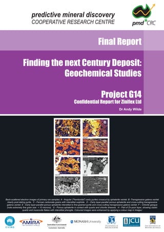
Back-scattered electron images of primary ore samples. A - Angular ("framboidal") early pyrites crosscut by sphalerite veinlet. B -Transgressive galena veinlet
clearly post-dating pyrite. C - Ferroan carbonate grains with interstitial sulphide. D – Early layer-parallel porous sphalerite and cross-cutting transgressive
galena veinlet. E - Early layer-parallel porous sphalerite interstitial to fine-grained pyrite and cross-cutting transgressive galena veinlet. F – Chlorite gangue
(note extremely fine grain size < 10 microns). G - Porous sphalerite in contact with quartz and chlorite sheaves. H - Part of Zn-poor layer, showing clastic
quartz and muscovite flakes with interstitial phengite. Coloured images were enhanced by applying a colour map in ImageJ
2. G14: Finding the next Century Deposit:
Geochemical Studies
Final Report
May 2006
Compiled by:
Andy Wilde
School of Geosciences
PO Box 28E
Monash University
Victoria 3800
Australia
Ph: 03 9905 1140
Email: andy.wilde@sci.monash.edu.au
i
3.
4. Table of Contents
1 Executive Summary ....................................................................................................... 1
2 Introduction..................................................................................................................... 3
3 Geological Setting.......................................................................................................... 4
4 Mineralogy of Primary Ore and Unaltered Rocks........................................................ 7
5 Mineralogy of Weathered Zone ................................................................................... 11
6 Bulk Chemical Characteristics.................................................................................... 14
6.1 Lady Loretta and McArthur River........................................................................ 14
6.2 Century ............................................................................................................... 16
6.3 The impact of near surface oxidation (weathering)............................................. 20
6.4 Soil iron anomalies ............................................................................................. 22
7 Carbonate Composition............................................................................................... 23
8 Stable Isotopes............................................................................................................. 26
10 Infra-red Response....................................................................................................... 29
10.1 Minerals detected in IR Spectra.......................................................................... 30
10.2 Variation in Spectral Parameters ........................................................................ 32
11 Illite Crystallinity........................................................................................................... 35
12 Magnetic Susceptibility................................................................................................ 37
13 Density........................................................................................................................... 40
14 Geochemical Process Models..................................................................................... 42
14.1 Questions to be addressed................................................................................. 42
14.2 Constraints.......................................................................................................... 42
14.3 Basic Controls on Pb and Zn Solubility............................................................... 44
14.4 Mixing of Brine and Seawater (Exhalative Model) .............................................. 46
14-5 Mixing of Brine and H2S Gas ............................................................................. 47
14.6 Mixing of Brine and CO2 Gas ............................................................................. 48
14.7 Mixing of Brine and Ch4 Gas.............................................................................. 49
14.8 Mixing of Brine and Gas Mixtures....................................................................... 50
14.9 Fluid-rock Reaction - Dolomite ........................................................................... 50
14.10 Fluid-rock Reaction - Carbon.............................................................................. 51
14.11 Fluid-rock Reaction – Lawn Hill Shale ................................................................ 52
14.12 Metal Sources and Depletion.............................................................................. 53
14.13 Sulphur Source/s ................................................................................................ 55
14.13 Source of Chlorine .............................................................................................. 56
15 Conclusions.................................................................................................................. 57
15.1 The Century Footprint......................................................................................... 57
15.2 Chemical Process Model .................................................................................... 57
15.3 Recommended Further Work ............................................................................. 58
16 References .................................................................................................................... 59
17 Appendix 1 – Data Disk................................................................................................ 61
ii
5.
6. pmd*CRC Final Report – G14 Finding the next Century Deposit: Geochemical Studies
1
1 Executive Summary
• Geochemical modelling best approximated the ore-bearing shales by interaction of oxidised brine and
unaltered carbon-bearing shale, although massive dolomite also precipitated galena and sphalerite.
Reduction is thought to be a key depositional process. Many rocks of the McNamara Group could
therefore host ore, including carbonaceous dolomite. The key constraint on ore formation could be
permeability and porosity rather than chemical composition.
• Interaction of hot hydrothermal fluid and pre-existing carbon (liquid hydrocarbon?) would have
modified the precursor (hydro-) carbon and imparted characteristics such as enrichment in poly-
aromatic hydrocarbons (PAH) as observed at the McArthur River mine (Chen et al., 2003). This
mechanism could also have generated increased porosity and permeability leading to ore grade
accumulations of zinc.
• Furthermore, there is no need to invoke a separate reduced fluid and fluid mixing. It is possible that
sulphur was introduced as sulphate and could therefore be derived from dissolution of anhydritic
evaporites at depth. In which case exploration should be confined to areas underlain by evaporitic
sediments.
• Siderite-rich siltstones probably result from hydrothermal processes, consistent with enrichment in Zn
and apparent restriction to the Century orebody. Two chemical models approximated formation of the
sideritic siltstones: mixing of oxidised brine and contemporary seawater (in a rock-absent
environment) or mixing of brine with CO2 gas. The siltstones may therefore represent a precipitate at
the ocean floor or the product of mixing sub-surface under conditions of high porosity and
permeability.
• The source of metal remains a matter for conjecture, but a possible depletion zone in Lawn Hill
formation rocks has been identified extending up to 6km from Century. Data are insufficient to
speculate on the volume of depleted rocks and metal available for transport.
• The ore zone is characterized by bulk chemical enrichment in Fe, Mn and S due to abundance of
ferroan carbonate (primarily zincian siderite) and pyrite. Thus, rocks of the ore zone have higher
density and magnetic susceptibility than unmineralised rocks of the hanging wall and footwall.
Forward modelling of the Century ore and host-rocks is warranted in order to establish whether
gravity or gravity gradiometry (airborne gravity) could be useful exploration tools. Susceptibility
measurement is suggested as a rapid and low cost tool for identifying altered rocks in drillcore and
chips. It should be noted, however, that sampling is very biased towards the pit area and more
samples should be measured beyond the pit, to add confidence to these conclusions.
• Reassessment of analytical data for carbonate minerals disproves the concept of a siderite “halo”
about Century but shows that the rare Fe-Mg carbonates sideroplesite and pistomesite occur widely
in the region. Zincian siderite sensu stricto is, however, limited in occurrence to the pit area. The
possibility that partial extraction of rock carbonate could be more effective than conventional bulk
analysis should be investigated.
• An important question that remains unresolved is the extent of the hydrothermally-altered rocks
beyond the pit area. Thus far, none of the holes sampled revealed hydrothermally altered rocks
comparable to those in the pit. It is rare however for the host Pmh4 unit to be intersected beyond the
pit area. On the other hand at least some of the layering characteristics of Pmh4 – notably sideritic
siltstone layers are likely to be due to hydrothermal processes. Some resolution of this issue may be
obtained by a comparable study of the McArthur River deposit, where the transition from ore zone to
alteration zone may be unambiguously preserved.
• Infra-red (MicaAlOH) and illite crystallinity (IC) anomalies are more extensive than bulk chemical and
carbonate anomalies. All >5% iron in soil anomalies fall within these mineralogical anomalies.
Identification of mineralized rocks in drillcore and chips could be aided by use of an infra-red
spectrometer such as HYCHIPS or PIMA. This possibility that outcropping alteration zones could be
identified by remote-sensed hyperspectral imagery should be assessed in the next year of this
project.
7. pmd*CRC Final Report – G14 Finding the next Century Deposit: Geochemical Studies
2
• This study has focussed on the expression of the Century deposit, but further work should also
examine the nature of the (thus far) smaller structurally-controlled deposits such as Silver King and
determine whether the alteration associated with these deposits is distinctive. Radiometric dating
should also be attempted in order to establish whether these deposits are separated in time from the
main Century mineralization event.
8. pmd*CRC Final Report – G14 Finding the next Century Deposit: Geochemical Studies
3
2 Introduction
This report summarises the results of research into chemical aspects of ore deposition and hydrothermal
alteration at the Century Zn deposit, conducted between 2004 and 2006 as part of project G14 of the
pmd*CRC.
More detailed accounts of aspects of the research can be found in various reports by the author detailed
in the reference section.
A compilation of existing data together with all new data collected is presented as an ACCESS database
bound with this report. A summary of the database structure and its contents is included as Appendix 1.
9. pmd*CRC Final Report – G14 Finding the next Century Deposit: Geochemical Studies
4
3 Geological Setting
Two main Proterozoic units are recognized in the Century area (Fig. 1), the older McNamara Group, host
to the ore at Century and the unconformably overlying South Nicholson Group (Roper Superbasin of
Jackson et al., 1999). The stratigraphy of the McNamara Group is summarized in figure 2 and a more
complete account can be found in Andrews (1998). The Century deposit appears to be unusual in
comparison to other major Pb-Zn deposits of the region in being hosted by relatively deep-water
sediments (Broadbent et al, 1998). No igneous intrusions are known within 25 km, and the only volcanic
rocks are sparse outcrops of the Kamarga Volcanics, approximately 25km east of Century. Volcanic rocks
may occur at depth below the Century mine at the base of the McNamara Group.
Figure 1: Simplified geology of the area around Century. Oolitic ironstones of the Mullera Formation are shown in red. Stars show
small sub-economic occurrences of Pb and Zn.
Figure 2: Stratigraphy of the McNamara Group with detail of the mine sequence.
10. pmd*CRC Final Report – G14 Finding the next Century Deposit: Geochemical Studies
5
The Lawn Hill formation attains a maximum thickness of 2.2 km and has been divided into five members
(Andrews, 1998). It is unit 4 that hosts the ore. Figure 2 shows part of unit 4, and illustrates an important
characteristic of the ore sequence, namely the alternation of carbonate-rich siltstones and carbonaceous
shales, the latter containing the bulk of the economic ore.
The South Nicholson Group ranges in thickness to over 2km but only a few hundred metres are
preserved in the vicinity of the Century mine (Jackson et al., 1999). The basal unit west of Century is the
Constance Sandstone, which is dark red at outcrop reflecting the abundance of hematite and other iron
oxides/hyroxides. Overlying the Constance Sandstone is the Mullera Formation, which contains unusual
and extensive oolitic ironstones, which outcrop over 50km of strike. These ironstones are estimated to
contain 322 million tonnes of iron ore at approximately 47% Fe (Harms, 1965).
The Century deposit is partly overlain by unconformable Cambrian limestone. The nature of the contact is
complex, and calcite-cemented breccia dykes intrude the ore sequence. Feltrin et al. (2003) describe 2 –
3cm wide veins of quartz, siderite, sphalerite, galena and pyrite that “pervade the nodular zone in the
Cambrian limestone”. A large body of mineralized Proterozoic rock occurs as a megaclast (of 1 million
tonnes) in the limestone sequence (Broadbent et al., 1998).
Proterozoic rocks in the vicinity of Century are folded into an open synform with a north-south trending
axis, the Page Creek Syncline, but elsewhere in the region folding can be tight, as is apparent from
elongate map patterns north of Century (Fig. 1). North-south trending folds are correlated with the major
Isan orogenic (D2) event of the Mount Isa region (Broadbent et al., 1998).
The most obvious fault in the area is the NNW-SSE trending Termite Range fault, which extends over
tens of kilometers. It is thought to be long-lived and to have controlled sedimentation of the McNamara
Group and basin evolution. NE-SW faults are also prominent and locally host structurally controlled
deposits such as Silver King. Major faults within the pit area are the north-dipping Magazine Hill and
Pandora's faults. Displacement across the former is of the order of 300m and varies from almost 0 to
200m across Pandora's fault. The NE-SW faults are correlated with D3 faults of the Mount Isa region
(Broadbent et al., 1998) which are implicated in copper ore formation in this area.
.
Figure 3: Histogram of K-Ar model ages, Ar-Ar plateau ages and Rb-Sr isocron ages of rocks from the Lawn Hill region. (Sources
detailed in text).
11. pmd*CRC Final Report – G14 Finding the next Century Deposit: Geochemical Studies
6
Figure 4: TEM image of mica in carbonaceous material in a sample of the Lawn Hill Formation distal to Century. K-Ar ages of these
micas are in the range 1175±50Ma (Uysal et al., 2004). Compare this with Fig. 7 below.
Two samples of tuffaceous layers within the Lawn Hill formation have been dated by the SHRIMP zircon
technique at 1616±5 and 1611±4 Ma (Page et al. 2000). A tuff sample from LH539, 5km east of Century
yields a significant number of younger ages in the range 1400 to 1000 Ma. The significance of these ages
are unclear to Page et al. (2000) but this age range is also recorded in K-Ar, Ar-Ar and Rb-Sr systems
(Fig. 3). Zircons from feldspathic sandstone of the Constance Sandstone yielded an age of 1591±10,
apparently contradicting evidence of a major unconformity (Jackson et al., 1999). This paradox has been
reconciled by interpreting the ages to reflect redeposition of zircons sourced in the Lawn Hill Formation
(Jackson et al., 1999). A better estimate of the depositional age of the South Nicholson Group is based
on zircons from units higher up the sequence which yielded ages of 1492±4 and 1493±4Ma (Jackson et
al., 1999).
K-Ar and Rb-Sr ages reflect one or more post-McNamara thermal events (Fig. 3; Kralik, 1982;
MacDougall et al., 1965; Uysal et al., 2004). There are distinct maxima of model K-Ar ages at 1300 –
1350 and 1150 – 1200 Ma. Two Ar-Ar determinations on mica from the Flat Tyre deposit yielded a
plateau age of 1562±34 Ma and distinct plateau ages of 1310±6 and 1355±6 Ma in the other (P. Polito,
unpub. data).
Six K-Ar determinations on fine-grained mica intimately associated with carbonaceous material in rocks of
the Lawn Hill Formation distal to ore yielded ages of 1175±50 Ma (Uysal et al., 2004). The fine grain size
of the analysed micas (<1 µm), however, raises concerns about possible radiogenic argon loss and
artificially young ages. Nevertheless, there is additional evidence of a relatively late hydrocarbon
migration event in hydrocarbon-bearing quartz-calcite veins that cut a mafic dyke which intrudes rocks of
the Roper superbasin (Volk et al, 2005). The age of the mafic dyking event is poorly defined at between
1220 and 1280 Ma by the K-Ar method on plagioclase and 1150 Ma on pyroxene (errors not given;
McDougall et al., 1965).
There is textural and other evidence for multiple lead and zinc depositional events (e.g. veins in Cambrian
rocks) and the possibility that Zn- and C-rich ore is of different age to the lead-rich transgressive veins
(see below). In which case Pb isotopic data could be dating the veining event but not the primary ore.
This uncertainty will be resolved by:
• Dating the age of Lawn Hill sedimentation using the Re-Os technique on carbon assumed to be syn-
sedimentary (Monash University, Bruce Scheaffer)
• Dating the carbon-rich ore also using Re-Os technique on carbon assumed to be hydrothermally
modified (Monash University, Bruce Scheaffer)
• Dating the late transgressive ore using Rb-Sr (Melbourne University, Roland Maas)
12. pmd*CRC Final Report – G14 Finding the next Century Deposit: Geochemical Studies
7
4 Mineralogy of Primary Ore and Unaltered Rocks
There are at least two end-member ore types at Century. One is stratiform, zinc- and carbon-rich the
other is transgressive, veinlet-controlled and lead-rich. These ore types may occur together at the hand
specimen scale. Small occurrences beyond the Century pit area appear to be mainly of this second type.
XRD data for 77 samples of stratiform ore with sphalerite > 1 vol% show that the primary ore is dominated
by quartz, sphalerite, siderite, white-mica and pyrite (Fig. 5).
0
10
20
30
40
50
A
lbite
C
alcite
C
hloriteD
olom
ite
G
alenaK
aoliniteM
uscoviteK
feldspar
Pyrite
Q
uartz
R
utileSphalerite
Siderite
AverageVolume%Mineral
Unaltered Shale (n = 9)
Primary Ore (n = 77)
Figure 5: Average mineral composition of 77 samples of primary ore (defined as sphalerite > 1% by volume)
Quartz occurs as what appear to be relict clastic grains, but which often have irregular and even lobate
outlines suggestive of partial dissolution (Fig. 6g,h). Sphalerite occurs as so-called porous sphalerite (Fig.
6e,g) which occurs as laminae parallel to presumed sedimentary layering and in veinlets transgressive to
and probably later than the porous sphalerite (Fig. 6d,e). Pyrite in the primary ore samples typically
occurs as distinctive angular or rounded grains typically less than 10 microns in diameter (Fig. 6a,b,e).
This clearly pyrite predates "porous" sphalerite, which envelopes and encloses it. There is no textural
evidence that the sulphur in this early pyrite was used to form the sphalerite (i.e. the abundance, shape
and surfaces of the pyrite seem to be the same regardless of whether sphalerite is present).
Veinlets of galena postdate framboidal pyrite and porous sphalerite (Fig. 6b,d,e). Fig. 6f,g shows the
occurrence of sheaves of probable chlorite. The identification of chlorite is tentative based on Mg and Al
in X-ray spectra, but another clay phase could be present. Fig. 6h shows a portion of sample AW04-009
that is more representative of the host-rock. Detrital quartz and mica are apparent and pore-filling of
extremely fine-grained material (< 5 microns) possibly phengite. This clearly illustrates one of the
problems in studying these rocks: the very fine-grained nature.
TEM studies of Century ore have been published by McKnight and Broadbent (1993) and Broadbent. and
McKnight (1993). Some of this work is shown as Fig. 7 (courtesy of Stafford McKnight). Some
conclusions from this work are that sphalerite is extremely fine-grained (< 1 µm) strongly suggestive that
the ore has not been recrystalised (e.g. during metamorphism). Furthermore, “porous” is not an
appropriate description, the ore consisting of myriad crystallites of ZnS “floating” in bitumen. Not all
organic matter displays the same level of maturation and some appears to have a higher rank than would
be expected from other measures of geothermometry (e.g illite crystallinity).
As with many orebody studies the mineralogy of unmineralized host-rocks is less well established than
that of the ore. In this case, few samples of shale equivalent to mineralized shale have quantitative XRD
mineralogy. The average volumetric mineral compositions of unaltered shale are shown in Fig. 5. This
13. pmd*CRC Final Report – G14 Finding the next Century Deposit: Geochemical Studies
8
figure suggests that the differences between ore and host-rocks are that the ore rocks have greatly
reduced amounts of quartz and muscovite, due to addition of sphalerite, ferroan carbonate and pyrite.
Dolomite is present in the unaltered rocks but virtually absent in the mineralised rocks consistent with the
EMP evidence cited below. Chlorite is also present in unaltered rocks but virtually absent in the
mineralised rocks, although is present in the oxidised hematitic rocks above the ore.
This leads to the important conclusion that the ore and unaltered host-rocks are not mineralogically very
different. The main distinction appears to be the presence of siderite and pyrite in ore.
14. pmd*CRC Final Report – G14 Finding the next Century Deposit: Geochemical Studies
9
Figure 6: Back-scattered electron images of primary ore samples. A - Angular ("framboidal") early pyrites crosscut by sphalerite
veinlet. B Transgressive galena veinlet clearly post-dating pyrite. C Ferroan carbonate grains with interstitial sulphide. D – Early
layer-parallel porous sphalerite and cross-cutting transgressive galena veinlet. E - Early layer-parallel porous sphalerite interstitial to
fine-grained pyrite and cross-cutting transgressive galena veinlet. F – Chlorite gangue (note extremely fine grain size < 10 microns).
G Porous sphalerite in contact with quartz and chlorite sheaves. G Part of Zn-poor layer, showing clastic quartz and muscovite
flakes with interstitial phengite. Coloured images were enhanced by applying a colour map in ImageJ
15. pmd*CRC Final Report – G14 Finding the next Century Deposit: Geochemical Studies
10
Figure 7: TEM Images of Century ore from studies of McKnight and Broadbent (1993) and Broadbent and McKnight (1993). A, B
Typical “non-porous” Century sphalerite. “Cryptocrystalline or “ultra-fine polycrystalline” are better descriptors.C, D - Myriads of
crystallites of ZnS “floating” in bitumen (paler material). E, F - Highly bituminous “porous” sphalerite x30,000. Paler material is
bitumen. G, H - amorphous organic matter (OM) with sphalerite crystallites. Images courtesy of Stafford McKnight.
16. pmd*CRC Final Report – G14 Finding the next Century Deposit: Geochemical Studies
11
5 Mineralogy of Weathered Zone
The upper parts of the Century pit contain rocks that contrast markedly with the primary ore rocks just
described. These rocks are pale greenish gray to blood red, depending on the mass of hematite. The
interface between such hematitic rocks and dark-coloured primary ore generally defines the upper limit of
economic zinc (Fig. 8). Several samples of the hematitic material were examined to determine whether
these rocks represent a facies of primary hydrothermal alteration, or whether they represent a post-ore
event such as surface-related oxidation (weathering).
Figure 8: Interface between primary ore (dark gray) and hematitic zone – red dotted line. Samples are yellow crosses (prefixed
AW04-). Rod Anderson provides a scale. Note the enormous drop in grade below and above the line.
Texturally, the hematitic rocks generally appear similar to the primary ore, in that layering is well
preserved, with siltstones being preferentially hematised. Calcite-cemented breccias and calcite veinlets
are quite common in this zone. Calcite can be coarse and euhedral possibly indicative of open space
filling. NITON portable XRF analysis (Wilde, 2004) reveals that hematitic rocks are more Zn-rich than
adjacent hematite-poor rocks. From XRD data it is clear that calcite, kaolinite, hematite and chlorite are
more abundant in the rocks of the hematitic zone while sphalerite and K-feldspar were not detected. No
evidence of replacement of sphalerite-rich layers is apparent in the hand specimens or in the open pit.
SEM images of the textures present in the hematitic rocks are shown in Fig. 10. Iron oxide is often
spatially associated with fine-grained chlorite (consistent with the XRD evidence of increased chlorite
concentration relative to primary ore). Oxide (hematite) is often best developed at the contact between
host-rock fragments and calcite-rich veins (as in Fig. 10c). In one instance oxide was seen to be replacing
sphalerite in a sphalerite-quartz vein (Fig. 10d) but this appears to be rare. The irregular contact between
calcite and oxide/chlorite and the fact that the latter is enclosed in the former suggests that calcite
postdates chlorite and Fe oxide.
Hematitic alteration could be interpreted as a primary feature. In this case Zn would have been deposited
in reduced (carbon-rich) rocks close to the interface with oxidized, hematitic, rocks. This interface would
have been discordant to layering, and could explain why economic grades occur only at and beneath this
interface. Hematite visually similar to that in the Proterozoic rocks is, however, present in Cambrian rocks,
suggesting that hematite formation post-dates deposition of the unconformable Cambrian cover.
Alternatively detrital hematite could have been incorporated into these sediments, but the textures do not
support this interpretation.
I found no evidence that discordant post-ore hematitic alteration has removed primary zinc, and this could
be used as an argument against a secondary origin. The base of this alteration may however simply
reflect a primary feature of the orebody. The presence of abundant sulphide and carbon in the primary
ore would have rapidly reduced any oxidized surface-derived fluid.
17. pmd*CRC Final Report – G14 Finding the next Century Deposit: Geochemical Studies
12
Figure 9: Transmitted light photomicrograph of Cambrian hematitic sandstone, showing what appears to be interstitial hematite.
AW05-034. Field of view approximately 10mm.
18. pmd*CRC Final Report – G14 Finding the next Century Deposit: Geochemical Studies
13
Figure 10: SEM images of hematite-rich rocks. A AW04-010. Note no obvious texture indicating sphalerite replacement. (Fine bright
white grains are sphalerite). B-D AW04-012. Textures such as B suggest that calcite and chlorite may not be in equilibrium. Calcite
apparently postdates chlorite and Fe oxide. E - AW04-014. Shows quartz, iron oxide (hematite?) and sphalerite vein. F. AW04-016
from the Termite Range fault showing chlorite enclosing and ? replacing quartz.
19. pmd*CRC Final Report – G14 Finding the next Century Deposit: Geochemical Studies
14
6 Bulk Chemical Characteristics
6.1 Lady Loretta and McArthur River
Bulk chemical and aspects of mineralogical variation around the Lady Loretta deposit were
documented by Carr (1984) based on 1,218 samples. Carr (1984) found that the proportion of
pyrite increases from about 2% in host-rocks 150m below the deposit to over 90% in the
immediate footwall to the deposit. There is also significant pyrite enrichment in the hanging wall
(to 20%) for up to 100m above the deposit. Clearly, ore is spatially coincident with unusually
pyritic rocks.
Ferroan carbonate is abundant in the ore and host-rocks in an "aureole that extends for 75m
beneath to 50m above the ore" (Figs. 11,12). Ferroan carbonate contains up to 13 mol% ZnCO3
and 32% MgCO3 and should therefore more correctly be referred to as sideroplesite (molar
MgCO3 5 - 30%) or pistomesite (molar MgCO3 > 30%). Carr (1984) observed that there is an
antipathetic relationship between the abundance of Zn and Mg in carbonate minerals, Mg
increasing with distance from ore.
Bulk-rock Zn, Hg, Pb, Ag and Ba show "extensive primary dispersion within the host-rocks".
Within the plane of sedimentation, haloes vary "in width" from 50m to 1.5km and these
dispersions are thought to be "dependent on the shape of the sedimentary basin floor at the time
of sedimentation". Zn and Hg show the most extensive primary dispersion with anomalous values
extending up to 100m into the footwall and at least 50m into the hanging wall.
Large and McGoldrick (1998) collected 108 new samples and developed several geochemical
"indices". They found that bulk chemical haloes extend for several hundred metres across strike
and up to 1.5 km along strike (corroborating Carr's earlier conclusions). Details of these haloes,
such as 3D extent and threshold values, however, were not provided. An inner "sideritic"
envelope to primary ore is surrounded by a zone of ankerite and ferroan dolomite that grades
outwards to low Fe dolomite. Fe-rich carbonate in the inner envelope includes both siderite and
PISTOMESITE (Fe0.6Mg0.4CO3). The zincian nature of these iron carbonates first documented by
Carr (1984) was confirmed.
Pb, Cu, Ba and Sr show dispersion of <50m across strike, Zn and Fe moderate dispersion (<
100m) and Mn and Tl show greatest dispersion at < 200m. Cu, Mg and Na are depleted in the
sideritic halo relative to surrounding sediments, while there is little systematic change in K. Two
bulk chemical vectors were developed (applicable to dolomitic rocks): SEDEX metal index: Zn +
100Pb + 100Tl and SEDEX alteration index: (FeO-10MnO)100/(FeO + 10MnO + MgO). A third
vector recognised systematic changes in the Mn content of carbonate with proximity to ore:
MnOd = (MnO*34.41/CaO)
These data suggest that deposition of Pb and Zn was accompanied by major bulk addition of iron
and manganese to the host-rocks or that ore is spatially coincident with unusually Fe- and Mn-
rich host-rocks. The timing of Fe and Mn enrichment relative to Zn and Pb introduction is not well
defined.
Lambert and Scott (1973) collected 160 samples from around the McArthur River deposit and
their data show that Fe enrichment is also a feature of the hanging wall sediments here. Iron
commonly exceeds 10%, probably reflecting large masses of pyrite. Conversely, distal to the
orebodies samples containing over 10% Fe are rare. Mineralized host rocks contain dolomite
with moderate to high Fe and Mn content. Siderite, however, has not been reported. The
apparent absence of siderite or pistomesite as key host-rock phases is apparently a major
difference between McArthur River and Lady Loretta. Mn in dolomite probably accounts for bulk
enrichment of Mn in the ore zone and immediate footwall to over 0.5% Mn. Considerable
enrichment of carbon in ore zone shales (to 13%) was noted. There is excellent correlation
between C and Fe and between C and S. Mineralized rocks are generally poorer in K than
unmineralized rocks (values in excess of 5% are common in the distal holes sampled by Lambert
and Scott, 1973). This conclusion can also be drawn from the data of Large et al., 2000. Host
rocks contain "significant Pb, As and Hg anomalies". Up to 0.7% Zn and 800 ppm Pb were noted,
however, in drillhole Myrtle 1 drilled about 20 km from McArthur River. Clearly, elevated Pb and
Zn are not confined to adjacent to orebodies. High As was attributed to solid solution in pyrite. Hg
20. pmd*CRC Final Report – G14 Finding the next Century Deposit: Geochemical Studies
15
in the ore is in the range 0.7 to 1.7 ppm compared to 0.05 to 0.15 ppm "background". Tl is
"concentrated preferentially in the ore deposit" where values of up to 100 ppm "are not
uncommon". Dispersion was not defined, although "low pyrite shales" were found to contain < 10
ppm (INAA analysis). Au, B, Bi, Ba, Cr, Ga, La, Li, Mo, P, Rb, Sc, Sr, Th, Ti, U, V, Y and Zr were
also analysed for but "showed no significant association with sulphide mineralization". The
absence of anomalies in Ba and Sr contrasts with Lady Loretta.
Additional data were collected by Large et al. (2000). They sampled two holes remote from the
deposit and compared them to six holes previously sampled by Lambert and Scott (1973).
Analysis was for major elements and "selected trace elements" (that remained unspecified).
They concluded that: "a broad Zn-Pb-Tl halo ... extends laterally along the favourable pyritic black
shale facies of the Barney Creek Formation for at least 15km west of the deposit".
Manganiferous carbonate forms the most pronounced and laterally extensive halo at HYC and is
offset from a ferroan dolomite/ankerite halo. Sedimentary rocks of the Barney Creek Formation
have a relatively simple mineralogy of dolomite, ankerite, illite, quartz, K-feldspar, pyrite, chlorite
and organic matter. Calcite occurs rarely and siderite has not been identified at HYC or
regionally within the McArthur Basin. Strongly pyritic shales extend up to 200m above the ore
zone, but there is a sharp drop to <1% below the deposit. Downhole K2O is controlled by illite and
K-feldspar. Illite is dominant around the ore zone. K-feldspar is dominant in holes remote from
HYC (Barney 3 and BMR 2).
I would argue that sampling two holes remote from an orebody does not permit the definition of a
halo which is by definition present on all sides of the orebody. Furthermore, it is not proven that
background values have been attained, so that the enrichments may be regional. Furthermore,
Mn in carbonate is to a large degree a reflection of bulk rock Mn and analysis of carbonates for
exploration is probably not warranted. Resolving this uncertainty should be an objective of the I7
project in FY06-07.
Figure 11: Isopachs of the Lady Loretta ore horizon and Lower Siderite Unit (from Carr, 1984)
21. pmd*CRC Final Report – G14 Finding the next Century Deposit: Geochemical Studies
16
Figure 12: Distribution of pyrite in two holes from Lady Loretta 500m apart (Carr, 1984).
6.2 Century
In assessing the differences between mineralized rocks of the ore sequence and other rocks of
the McNamara Group I have compiled a total of 779 analyses of unmineralised rocks from
various sources (documented in the ACCESS database). Partial analyses of 13,779 grade control
samples are available in the PCM database (Tables 1, 2), and various studies notably Johnson
(2000) provide additional data on ore samples.
Table 1: Statistics for samples from Century in the PCM database containing >1% Zn. Method or methods of analysis are not
known.
Fe Mn Pb S TOC TOEC Zn SiO2 CaO K2O MgO P2O5
Number of values 11605 11184 13775 9072 671 1589 13779 1228 116 116 116 45
Minimum 0.4 0.0 -0.2 -0.1 0.0 0.0 1.0 4.3 0.2 0.7 0.1 0.2
Maximum 42.7 7.8 50.0 25.7 12.4 12.0 53.0 85.0 0.8 2.6 1.1 0.5
Mean 7.9 0.9 1.4 7.3 3.2 3.2 9.0 50.6 0.5 1.5 0.5 0.4
Median 7.4 0.8 0.4 7.2 3.3 3.3 5.6 50.1 0.5 1.4 0.4 0.4
Third quartile 10.5 1.4 1.4 11.3 4.5 4.3 14.8 59.9 0.6 1.6 0.7 0.4
Standard deviation 4.6 0.8 2.8 4.9 1.8 1.6 8.0 12.8 0.1 0.4 0.2 0.1
22. pmd*CRC Final Report – G14 Finding the next Century Deposit: Geochemical Studies
17
Table 2: Average composition of units from holes PCM350, 354 and 356 using bulk XRF (Source: Zinifex).
Iron and manganese enrichment is a distinctive feature of the ore zone at Century (Tables 1, 2;
Fig. 13). The average Fe and Mn concentrations of samples with > 1.0% Zn are 7.9% and 0.9%
respectively. It is rare for any distal rocks of the McNamara Group to have iron concentrations in
excess of 6.0% and Mn in excess of 0.5%. The siltstone layers of the mine sequence are
significantly more Fe- and Mn-rich than the shales averaging in excess of 9.0% Fe and 1.0% Mn
compared to values in the shales of between 3.0 and 7.0% Fe and 0.3 to 0.7% Mn (Table 2).
Distal shales of the Lawn Hill formation have corresponding average values of 3.7% Fe and
0.12% Mn, while siltstones have averages of 5.1% and 0.45%.
Iron enrichment at Century reflects abundance of iron-bearing carbonate minerals and pyrite (see
below).
The average MgO and CaO contents of 116 ore zone samples are 0.6 and 0.5% respectively.
Average MgO and CaO of 129 samples of distal shales of the Lawn Hill formation are 2.4% and
1.4% respectively, while 49 samples of siltstones average 2.3% and 2.3%. These bulk chemical
differences reflect the fact that dolomite is present distal to the ore zone but is rare within it. This
can be attributed to dissolution and/or replacement of dolomite by siderite in the ore zone,
alternatively primary deposition of siderite rather than dolomite. Note that siderite is not abundant
at McArthur River, and so the possibility that siderite is not directly related to ore formation could
be entertained (see also chemical modelling presented below)
The mean K2O content of nearly 116 zinc-rich (Zn > 1%) grade control samples is 1.5% (median
1.4%), significantly less than average values for unmineralized rocks of the Lawn Hill Formation
(Fig. 14). The mine sequence is depleted in K2O relative to the footwall rocks, which average over
4% (Table 2; Fig. 15).
The dominant and only K-bearing mineral in the ore zone is white mica, typically extremely fine-
grained (< 10 microns). Mica and K-Feldspar are abundant in distal unmineralized rocks,
suggesting K depletion represents loss of mica and K-Feldspar.
Unit Rocktype Count Pb% Zn% Fe% S% SiO2% Mn% Ctot% Ag Comments
155 Siltstone 2 0.01 0.25 9.9 0.1 69.6 0.10 0.4 2
160 Shale 1 0.71 0.04 10.4 9.5 56.5 0.01 4.6 29
165 Siltstone 2 0.01 0.20 9.4 0.1 69.7 0.12 0.8 2
170 Shale 1 3.69 0.11 19.0 20.7 38.7 0.01 4.9 75
175 Siltstone 1 0.89 0.05 6.7 4.4 74.5 0.02 1.8 14
180 Shale 1 0.01 0.01 1.3 0.0 77.2 0.04 0.3 3
The high Si suggests that this may not be a
shale.
185 Siltstone 1 0.01 0.12 8.1 0.2 71.0 0.08 0.9 3
190 Shale 1 1.73 0.31 14.6 12.8 44.7 0.53 5.7 33
195 Siltstone 1 1.29 1.45 10.2 0.9 58.4 1.80 3.0 5
200 Shale 5 2.33 11.17 3.6 8.4 56.1 0.16 4.8 136
311 Siltstone & shale 1 0.28 21.18 10.3 12.3 30.8 1.96 3.6 59
312 Siltstone & shale 1 0.52 14.19 9.1 7.5 43.4 1.67 3.4 27
320 Siltstone 5 0.51 3.13 17.1 1.7 43.0 1.88 4.1 3
410 Shale 7 1.36 15.82 5.1 9.8 43.2 0.35 4.5 26
420 Massive Dolomite 5 0.23 0.57 8.7 0.5 56.2 1.52 4.2 2
Note high Si content. Probably not massive
dolomite
430 Shale 3 0.36 13.37 8.1 9.9 46.2 0.76 4.1 36
440 Shale 1 0.01 1.65 12.9 0.8 48.8 2.44 4.1 0
450 Shale 7 0.05 3.91 8.6 7.4 51.1 0.20 3.4 29
460 Shale 6 0.01 5.15 9.4 7.6 48.1 0.82 3.6 9
UFHM Massive dolomite 1 0.01 0.01 3.0 0.7 67.9 0.06 1.6 4
Note high Si content. Probably not massive
dolomite
UFW Siltstone & shale 6 0.01 0.44 5.2 1.5 64.2 0.42 2.6 0
UFW10 Siltstone & shale 2 0.01 0.33 8.1 2.0 55.8 0.92 3.2 3
UFW100 Siltstone & shale 6 0.01 0.43 4.3 1.6 66.5 0.22 2.3 2
UFW20 Siltstone & shale 2 0.01 0.11 2.5 1.0 68.1 0.09 2.6 0
23. pmd*CRC Final Report – G14 Finding the next Century Deposit: Geochemical Studies
18
Figure 13: 3D perspective of pit area (major faults in gray) and sampled "intermediate" (LH) drillholes around Century. Yellow
shows area with Fe > 10% and red > 12.5% (generated using Leapfrog). Looking NE. Field of view is approximately 10 km. Termite
Range fault to right, Magazine Hill to left.
Figure 14 shows the variation of Fe and K with rocktype1
. The diagram is useful for discriminating
between “shales” (high K), siltstones and sandstones (moderate K) and dolomite (low K).
Several unmineralised rock units stand out as having unusually high Fe, these are 16 samples of
Riversleigh Siltstone and 13 samples of the Torpedo Creek Quarztite. The latter derive from GSQ
LH-3 where there are signs of hydrothermal silicification and chloritisation as well as elevated Cu
(to 415 ppm). The high Fe is therefore attributed to alteration at the unconformity between the
basal McNamara Group and underlying Yeldham Granite. The high-iron rocks of the Riversleigh
Siltstone have been confirmed by NITON analysis (Wilde, 2005b) and come from an interval in
petroleum well AMOCO 83-1 that may represent a favourable stratigraphic horizon.
Figure 14: Comparison of Fe% and K2O% in mineralized and unmineralized rocks. The diagram at left presents the average values
for unmineralized rocktypes and units, whereas the diagram at right presents data points for mineralized rocks (note that very few
analyses of ore samples have major element determinations for both K and Fe). Note the anomalous composition of the Torpedo
Creek Quartzite in hole GSQ-LH3.
High Ba appears to be a feature of the Lady Loretta Formation, while high Mn is apparent in the
Lawn Hill Formation. High P appears to be another feature of the Lawn Hill Formation, but high P
is also seen in the Torpedo Creek Quartzite dolomite and Gunpowder Creek sandstone. The
origin of the P enrichment remains uncertain. It could be a primary depositional feature or
1 The term shale is used here to describe all pelitic rocks although shale is probably inappropriate for these rocks that have undergone lower
greenschist-facies metamorphism and are somewhat more massive than a typical shale.
24. pmd*CRC Final Report – G14 Finding the next Century Deposit: Geochemical Studies
19
hydrothermal. Alteration associated with unconformity-type uranium, for example, involves
deposition of various phosphate minerals.
Figure 15: Graphic log of drill hole LH494 showing % variation in SiO2, Fe, Mn, S and Zn and ppm variation of Ag. 208 analyses
from Johnson (2000).
The bulk chemical characteristics of the ore zone relative to all other units of the McNamara
Group can be summarized thus:
• Enrichment in Fe and Mn (as at Lady Loretta and McArthur River) due to abundant pyrite (in
shale layers) and siderite (in siltstones).
• Depletion in SiO2. Zn shows a good inverse correlation with SiO2, with rocks containing 20%
Zn invariably having SiO2 lower than 45%.
25. pmd*CRC Final Report – G14 Finding the next Century Deposit: Geochemical Studies
20
• Depletion in K2O. The median K2O content of high grade ore is 1.5%. K depletion is probably
due to white-mica and K-spar dissolution, since both are more abundant in unmineralised
rocks.
• Elevated TOC. Correlation between C and Fe as documented at McArthur River is apparent
in holes from Century
• CaO and MgO in the mineralized samples are significantly lower, reflecting the paucity of
dolomite relative to unmineralized rocks.
Bulk chemistry is evidently a tool that will allow the identification of rocks that have similar
characteristics to the host-rocks at Century, McArthur River and Lady Loretta. What is not well
established is whether the elemental variations allow the delineation of a “halo”, whether the
distribution is more irregular (e.g. fault controlled) or whether such rocks are regionally extensive.
Table 3: Average chemical compositions of unmineralized rocks from the Century area
6.3 The impact of near surface oxidation (weathering)
One hundred bulk chemical analyses of outcropping rocks from around the Century mine are
stored in the ACCESS database (Wilde, 2004). These were compared with sub-surface samples
in order to assess bulk chemical changes due to weathering. The surface samples appear to be
biased towards sandstones and siltstones presumably because these rocks outcrop rather better
than shales.
Formation Lithology # SiO2% TiO2% Al2O3% Fe% Mn% MgO% CaO% Na2O% K2O% P2O5% As Ba Cu Ni Pb Zn
Lawn Hill
Formation
Cappucino Rock 8 66.5 0.3 8.7 4.3 0.65 2.3 2.9 0.22 2.67 0.44 9 273 38 16 39 52
Dolomite 1 27.2 0.2 3.3 1.8 0.10 6.2 28.7 0.50 0.93 0.03 3 121 3 4 5 48
Interlayered
Clastics
64 68.2 0.4 10.5 4.0 0.26 2.3 2.5 0.39 3.57 0.46 8 382 31 20 8 181
Sandstone 37 80.8 0.3 8.1 2.2 0.11 0.8 0.5 0.23 2.73 0.22 6 365 17 13 24 129
Shale 129 62.4 0.5 13.1 3.7 0.12 2.4 1.4 0.37 3.93 0.18 21 350 30 32 38 116
Siltstone 49 66.0 0.3 8.9 5.1 0.45 2.3 2.3 0.18 2.85 0.36 12 270 31 18 35 98
Tuff 25 72.7 0.3 12.3 2.1 0.18 1.2 0.5 0.07 4.41 0.07 4 477 8 8 16 62
Riversleigh
Siltstone
Breccia 1 62.3 0.5 12.7 5.7 0.02 1.4 0.2 0.86 4.56 0.11 55 536 28 36 37 46
Pyritic shale 4 58.0 0.5 12.7 7.5 0.02 1.2 0.2 0.11 4.44 0.13 87 700 27 26 63 54
Sandstone 8 73.6 0.3 10.5 2.4 0.05 1.9 1.0 2.01 3.17 0.08 9 587 18 12 18 84
Shale 11 68.4 0.4 14.1 7.4 0.02 1.7 0.3 0.95 2.55 0.10 66 342 23 20 43 58
Siltstone 12 68.5 0.4 12.4 2.2 0.08 2.1 2.1 1.22 4.06 0.09 17 629 14 12 15 46
Termite Range
Formation
Dolomite 8 5.0 0.2 1.0 0.25 18.2 29.4 0.14 0.14 0.14 4 15 0 3 6 18
Sandstone 46 81.3 0.2 6.0 1.1 0.08 1.4 2.0 0.07 2.29 0.05 8 258 27 7 20 20
Siltstone 3 1.7 0.06 1.3 3.83 5 449 22 7 10 22
Lady Loretta
Formation
Dolomite 11 21.6 0.1 3.8 1.0 0.07 15.3 19.6 0.14 1.10 0.03 7 1143 14 7 24 18
Interlayered
Clastics
7 59.2 0.4 13.9 3.4 0.09 3.0 3.2 0.13 6.12 0.10 17 839 11 9 35 134
Sandstone 1 82.3 0.1 10.3 0.4 0.08 0.3 0.0 0.01 1.25 0.05 18 572 5 6 37 240
Shale 22 59.3 0.4 14.7 2.5 0.09 3.0 3.5 0.14 5.71 0.13 27 766 9 13 61 116
Siltstone 54 50.8 0.3 9.7 3.4 0.14 5.4 8.4 0.13 4.31 0.10 29 1464 10 9 24 63
Paradise Creek
Formation
Dolomite 75 21.2 0.1 1.7 0.9 0.06 16.3 22.8 0.13 1.24 0.02 2 379 12 5 13 10
Gunpowder Creek
Formation
Dolomite 116 22.6 0.1 2.0 1.6 0.09 15.9 21.1 0.05 1.28 0.06 7 358 20 4 12 21
Interlayered
Clastics
24 50.0 0.3 7.7 2.8 0.09 6.6 9.2 0.06 5.02 0.19 24 219 34 11 16 9
Quartzite 5 311 44 10 20 12
Sandstone 7 73.0 0.1 3.4 1.6 0.06 3.3 5.8 0.03 2.45 0.72 22 280 173 21 22
Shale 9 62.1 0.3 8.1 1.7 0.04 4.0 5.8 0.06 5.86 0.18 24 557 101 24 15
Siltstone 6 43.7 0.2 5.4 1.8 0.09 9.3 13.7 0.08 3.46 0.14 17 429 39 31 40
Torpedo Creek
Quartzite
Dolomite 1 56.3 0.2 3.0 6.4 0.19 7.1 5.0 0.02 1.53 0.74 30 163 20 26 23
Quartzite 7 42 18 25
Sandstone 12 19.6 0.25 6.5 1.30 28 85 49 10 14 12
Shale 1 2.4 0.01 0.4 7.27 19 351 19 23 15 144
Siltstone 4 3.3 0.05 8.8 1.92 26 143 415 17 12 25
26. pmd*CRC Final Report – G14 Finding the next Century Deposit: Geochemical Studies
21
Table 4 demonstrates dramatic differences between unweathered and weathered samples. The
latter are much enriched in SiO2 and depleted in Al2O3, MnO, MgO, CaO, Na2O and K2O. In some
cases there also appears to be minor loss of Fe. These chemical trends are is consistent with
secondary silicification, and loss of carbonate minerals, perhaps related to development of
silcrete in the region. Loss in K2O reflects conversion of muscovite to kaolinite for white there is
infra-red evidence (see below). An important conclusion, therefore, is that the bulk composition of
surface samples may not be a reliable guide to the degree of primary hydrothermal alteration,
since key minerals have been removed.
Rocktype Type Count SiO2 TiO2 Al2O3 FeO Fe2O3 MnO MgO CaO Na2O K2O P2O5 TOC Ag As Ba Co Cu Ni Pb U Zn
LAWN HILL FORMATION
Interlayered silt & shale Unweathered 77 68.7 0.4 10.3 3.2 0.04 3.0 2.9 0.9 3.0 0.4 0.9 11 489 13 24 22 18 3 93
Weathered 1 78.4 0.4 8.9 2.5 0.01 0.8 0.4 0.0 2.1 0.5 0.0 2 349 12 26 29 102 3 215
Mineralized Shale Unweathered 10 64.3 0.5 12.1 3.5 2.0 0.40 2.3 1.7 0.4 3.8 0.3 3.9 18 371 258 42 33 182 8 285
Weathered 1 77.9 0.3 8.7 5.4 0.01 1.0 0.3 0.0 1.7 0.5 0.1 19 373 22 34 52 63 2 433
Sandstone Unweathered 54 77.8 0.3 8.5 3.3 0.8 0.28 0.9 0.3 0.1 3.3 0.1 -0.3 11 331 31 4 7 9 3 48
Weathered 6 87.6 0.2 5.0 2.4 0.08 0.2 0.1 0.2 1.6 0.1 0.0 -0.5 4 502 46 14 6 110 -1 61
Siltstone Unweathered 31 69.4 0.3 7.7 1.4 5.2 0.30 2.8 3.2 0.3 2.3 0.3 0.4 -0.1 13 326 13 27 21 11 2 56
Weathered 11 76.6 0.4 7.9 6.7 0.04 1.0 0.2 0.0 1.7 0.3 0.1 -0.5 8 299 13 29 16 82 -2 58
Tuff Unweathered 47 74.4 0.2 11.5 2.0 0.4 0.21 1.0 0.6 0.1 5.0 0.0 -0.5 3 686 6 2 3 14 6 40
Weathered 32 78.4 0.2 8.5 0.8 1.1 0.12 1.0 1.2 1.8 3.1 0.0 -0.5 2 811 24 8 3 12 2 21
RIVERSLEIGH SILTSTONE
Sandstone Unweathered 8 68.1 0.3 12.5 4.5 0.07 2.7 1.2 1.8 3.8 0.1 -0.5 11 570 26 16 14 13 2 85
Weathered 42 89.1 0.1 5.3 1.2 0.02 0.1 0.0 0.2 2.4 0.0 -0.5 8 648 43 13 5 18 1 39
TERMITE RANGE FORMATION
Sandstone Unweathered 81 69.1 0.2 5.1 0.8 0.6 0.13 4.1 6.2 0.1 2.0 0.1 -0.4 7 226 45 16 6 14 2 17
Weathered 60 88.9 0.2 5.8 0.9 0.01 0.2 0.0 0.3 1.4 0.0 -0.5 5 775 63 15 3 6 -2 15
Table 4: Comparison between bulk chemical composition of material from drillcore (unweathered) and surface samples (weathered)
27. pmd*CRC Final Report – G14 Finding the next Century Deposit: Geochemical Studies
22
6.4 Soil iron anomalies
Given the significance of iron enrichment in the ore zone, soil data were examined to determine
whether evidence existed of iron-rich rocks beyond the pit area. An arbritary threshold of 5% was
applied to the data and yielded several coherent anomalies (depicted in Fig. 16; as well as many
isolated points not shown). Many of the anomalies appear to be oriented NNW-SSE, but this
needs to be confirmed by more detailed sampling. Given the strong evidence of iron enrichment
accompanying Zn emplacement these anomalies could indicate the intersection with the surface
of a mineralized system or systems.
Figure 16: Iron in soil in excess of 5% (data supplied by Zinifex). The anomalous points have been interpreted to define NNW-SSE
trends and fall in four main areas (isolated high soil values have been excluded). Note that the Fe anomaly also defines a circular
pattern, possibly indicating the presence of an intrusion at depth?
28. pmd*CRC Final Report – G14 Finding the next Century Deposit: Geochemical Studies
23
7 Carbonate Composition
The PhD theses of Broadbent and Andrews provide 2,535 electron microprobe analyses of carbonate
minerals from the Lawn Hill Formation. Figure 17 shows the compositional range of carbonate minerals
from drillholes in the pit area (proximal) and kilometers from the pit (distal). There is clearly more
dolomite, ferroan dolomite, calcite and ferroan calcite in the distal holes, whereas carbonate minerals at
Century are mainly Fe-Mg solid solutions ranging from siderite to sideroplesite to pistomesite, with minor
ankerite.
Figure 17: Fe v Mg composition of carbonate minerals from Century (mole%). Note that most should be described as sideroplesite
or pistomesite rather than siderite. “Proximal” are samples from drillholes in the pit area, “distal” are from drillholes remote from the
pit area.
Another feature of the Fe-Mg carbonate minerals at Century is high Zn content, ranging up to 14 mole%
with an average of 1.48%. The average Zn content of distal carbonates is 0.05% with a maximum of
0.58%. The most zinc-rich carbonates are the poorest in magnesium (Fig. 18).
0
2
4
6
8
10
12
14
16
0 0.1 0.2 0.3 0.4 0.5 0.6 0.7 0.8 0.9 1
Molar Fe/(Fe + Mg)
MolarZn%
Figure 18: Mole% ZnCO3 in carbonates from the Century pit.
29. pmd*CRC Final Report – G14 Finding the next Century Deposit: Geochemical Studies
24
Figure 19: Pie charts show the volumetric proportion of different carbonate types as determined by EMP analyses. These data
show the widespread occurrence of pistomesite and sideroplesite, but that zincian siderite is restricted to the pit area. Siderite also
makes up a higher proportion of carbonate in the pit area. Note virtual absence of dolomite.
Figure 19 demonstrates that there is no evidence of a siderite halo as proposed by previous studies. The
Fe-Mg carbonates pistyomesite and sideroplesite are widespread in rocks distal to Century and form a
high proportion of analysed carbonate minerals. Zincian siderite, by contrast, is restricted to the pit area
and also constitutes a higher proportion of analysed carbonate here. Thus the presence of zincian siderite
indicates close proximity to ore.
30. pmd*CRC Final Report – G14 Finding the next Century Deposit: Geochemical Studies
25
This raises the possibility that partial extraction and analysis of bulk rock samples for Fe, Mg, Mn, Ca and
Zn might prove to be a valuable exploration tool, potentially providing better peak to background than
conventional bulk rock analysis. The key uncertainty is the extent of such anomalism.
31. pmd*CRC Final Report – G14 Finding the next Century Deposit: Geochemical Studies
26
8 Stable Isotopes
Stable isotopic data for carbonate mineral have been used previously to constrain ore depositional
models (Andrews, 1998; Broadbent et al. 1998; Polito et al., 2004) and variation in carbonate isotopic
composition has been used to define the extent of hydrothermal alteration at McArthur River (Large et al,
2001). The analysed carbonates at Century show an extraordinary range in major element composition
within individual thin sections. This suggests that the isotopic composition determined by bulk analysis will
result only in a meaningless average of multiple carbonate compositions. This notion is supported by the
data in figure 20 which shows a systematic variation in δ18
O and δ34
C relative to compositional range, i.e.
samples containing more magnesian carbonates have a lower δ18
O and more positive δ34
C.
Figure 20: Range of carbonate composition (mol%) determined by EMP in five samples collected by Broadbent (1999; C007, 042,
073, 151 and 206). δ
34
C and δ
18
O are shown in bold red, with sample number and number of EMP analyses in black.
Figure 21: Stable isotopic data for carbonates from Century (Broadbent, 1999; Andrews, 1998).
Figure 21 shows the Century data relative to data from McArthur River and Mount Isa (and carbonatites).
The Century data show a greater spread which is attributed here to the problems of compositional
variability and bulk analysis.
32. pmd*CRC Final Report – G14 Finding the next Century Deposit: Geochemical Studies
27
A relatively small proportion of the data from Century are from outside the pit area (Fig. 22). The analyses
from the ore zone appear to a have a much greater spread in both δ
18
O and δ
34
C, but this may simply be
a function of the lack of samples beyond the ore zone.
Figure 22: Oxygen isotopic composition of carbonate minerals from the Century pit and surrounding drillholes.
33. pmd*CRC Final Report – G14 Finding the next Century Deposit: Geochemical Studies
28
9 Lead Isotopes
Lead isotope data for the region around Century were provided by Graeme Carr. The sample locations
and minimum 206/204
Pb ratios are shown in Fig. 23. Values below 16.4 are found within the illite
crystallinity/mica AlOH anomalies and also in the vicinity of Anglo American and Little Banner and Silver
Queen deposits. Other locations have higher values.
Figure 23: Minimum
206/204
Pb ratios of samples from the Lawn Hill mineral field (Carr, unpub. data). Note that minimum values less
than 16.4 seem to define the area around Century and coincide with IC and mica ALOH anomalies.
There is a suggestion that the isotopic data define an anomaly that includes Century, and therefore may
be useful as an exploration guide. Alternatively the data may be reflecting the age of lead emplacement
and identifying the cluster of structurally controlled deposits around Silver Queen as being of different
timing. This could be resolved by collection of additional isotopic data and attempting to data some of the
structurally controlled deposits, for example using Rb-Sr on sphalerite.
34. pmd*CRC Final Report – G14 Finding the next Century Deposit: Geochemical Studies
29
10 Infra-red Response
The database of infra-red measurements of rocks from Century contains 1,314 spectra, which have been
interpreted and parameterised by Ausspec. The spectra include:
• 499 surface samples from project I1 (none from Century, but includes spectra from structurally
controlled deposits at Lilydale and Watson's Lode)
• 32 surface samples collected by Graeme Broadbent used in XRD analysis
• Four "distal" drillholes: Amoco 83-1, Amoco 83-2, Argyle Creek 1 and GSQ LH3
• Eight "intermediate" drillholes: LH191, 195, 203, 218, 376, 418, 658, 691 (samples were supplied
direct to the CSIRO lab by Rod Anderson, except LH203, which was sampled by Graeme Broadbent).
• Three "proximal" drillholes from the stage 4 open pit: PCM350, 354 and 356
Early analyses were conducted with PIMA (portable infra-red mineral analyzer) which provides data in the
short-wavelength infra-red (SWIR) region. Later analyses utilized HYCHIPS at CSIRO’s North Ryde
laboratories, and this method yields additional data in the visible and near infra-red range (VNIR). The
latter is useful for identification of oxide, hydroxide and sulphide minerals.
Figure 24: Location of surface samples showing MicaAlOH parameter. The orange line defines areas in which micaAlOH > 2210
(i.e. mica is dominantly phengitic). Purple areas are anomalous iron in soil (>5%). Red shows area of illite crystallinity > 0.65. Note
the possible NNW-SSE trend in MicaALOH values extending over 20Km north of Century. This is also a trend occupied by many of
the smaller structurally-controlled deposits.
35. pmd*CRC Final Report – G14 Finding the next Century Deposit: Geochemical Studies
30
The locations of the 531 surface samples are shown in Fig. 24. There are 783 spectra from drillholes,
mostly of unweathered material.
10.1 Minerals detected in IR Spectra
White mica is the dominant mineral detected in most unweathered and unmineralized samples of
the Lawn Hill and Termite Range Formations and Riversleigh Siltstone, including samples from
drillholes adjacent to the pit area but carbonate and chlorite were also detected in a large
proportion of these samples (Fig. 25). Dolomites of the Gunpowder Creek Formation and
dolomitic siltstones of the Riversleigh Siltstone yield spectra dominated by carbonate (dolomite
and ankerite) with subordinate white-mica, as do the Lady Loretta and Paradise Creek
Formations. Quartz- and/or carbon-rich rocks, however, yield poor and noisy spectra. The
Constance Sandstone samples (Fig. 25) have low absorption probably because of the
abundance of quartz. The resulting weak spectra are dominated by kaolinite and chlorite and
some contain dickite making this unit spectrally distinctive. Chlorite has been confirmed as an
abundant phase in samples of the sandstone from the Constance Range iron deposits by SEM
analysis. Thus it is difficult to differentiate stratigraphic units using infra-red mineralogy, but shale
is readily distinguished from dolomite and sandstone. This implies that remote-sensed data
should be useful for lithological mapping.
White mica was also detected in nearly every spectrum of unweathered rock from the Century pit,
both shales and siltstones (e.g. Fig. 25b), while indications of carbonate and chlorite were found
in approximately half. The mineralized and unmineralized samples, are not spectrally distinctive
in terms of minerals that are detected. The relative intensity of the various illite peaks, however
differ markedly (compare Fig 25a and b) which translates to massive variation in the micaXT
parameter (see below).
HYCHIP analysis permits identification in siltstone samples from the ore zone of a broad
absorption feature at approximately 1150 nm with two distinct minima (Fig. 25d, and also one
spectrum in Fig. 25b). This feature is tentatively identified as due to ferroan carbonate2
. Although
the analysis of the distal samples does not extend to the VNIR range, it seems unlikely that this
feature is present as the edge of the feature would be recorded by PIMA. There are also several
absorption features in the range 500 – 700 nm which are due to either pyrite or hematite (in
weathered samples).
Minerals detected in surface samples but generally not abundant in sub-surface samples include
gypsum3
, alunite and jarosite. The latter minerals were found in samples from abandoned
workings as noted by the I1 team, but are certainly not restricted to the workings. Plotting the
distribution of these minerals using hyperspectral imagery may be a useful exercise. Kaolinite
and montmorillonite are much more frequently encountered in the surface samples, while
carbonate is relatively uncommon. These reflect inferences on weathering from bulk chemistry
discussed above.
2
This feature accounts for the low values of Fe slope recorded in the ore zone (see next section)
3
Gypsum was found in samples from intermediate holes and Ausspec cautioned that this might be a secondary product (e.g. due to recent oxidation of
the samples post-drilling).
36. pmd*CRC Final Report – G14 Finding the next Century Deposit: Geochemical Studies
31
Figure 25: Selected infra-red spectra. See text for discussion. Note that figures to the left were generated using PIMA which
measures only in the short-wavelength region, whereas spectra to the right were generated with HYCHIPS which measures down
into the near visible and near infra-red region.
37. pmd*CRC Final Report – G14 Finding the next Century Deposit: Geochemical Studies
32
10.2 Variation in Spectral Parameters
As noted previously, unweathered samples from the ore zone are characterised by significantly
higher values of micaXT ("mica crystallinity") and lower Fe slope (Fig. 26; Wilde, 2005) compared
to those in distal holes (Amoco 83-1, Amoco 83-2, Argyle Creek 1, GSQ LH3). Only one of the
intermediate drillholes (LH658) returned comparable values (from about 280m depth). None of
the other unweathered samples intermediate or distal drillholes contained spectra with this
signature.
MicaXT in surface (weathered) samples shows almost no overlap with the mineralised population
(Figs. 26 and 27). Samples from north of Century have uniformly low values of Mica XT at <1.5.
Values in excess of 2 occur at Century (in the weathered portions of PCM holes) and around the
Termite Range fault, at least as far as 15 km from Century. There is no systematic relationship
between MicaXT and the presence of kaolinite, which is recorded in virtually every analysed
sample. Five of the six highest values, however, occur in samples in which alunite was also
inferred (possibly indicating former presence of sulphide minerals).
Figure 26: Infra-red MicaXT versus Fe Slope parameters from samples from drillcore. Note the extremely good separation between
ore zone and distal samples.
Figure 27: Infra-red MicaXT versus Fe Slope parameters from surface samples. The trend towards higher micaXT is due to
kaolinite admixture.
38. pmd*CRC Final Report – G14 Finding the next Century Deposit: Geochemical Studies
33
The MicaAlOH parameter shows a quasi-systematic change from north to south, with higher
values encountered to the south and west of the Termite Range fault (Fig. 28). This is somewhat
consistent with an increase in illite crystallinity from north to south (see Wilde, 2005). The
MicaAlOH parameter does, however, not appear at this stage to be a direct guide to the presence
of mineralization, and could be an indication of hydrothermal alteration, of metamorphic grade or
the presence/absence of detrital mica. A more systematic (grid-based) set of samples from the
vicinity of Century is required, however, in order to clarify this.
The 32 surface samples collected by Graeme Broadbent have both SWIR micaXT and illite
crystallinity determinations from conventional XRD (carried out by Stafford McKnight; Fig. 29).
There is poor correlation between the two datasets, reflecting the fact that the XRD and IR
methods are recording different aspects of the mica composition and structure. The micaXT value
is affected by the presence of kaolinite, for example. The IC value determined by XRD is to some
extent a reflection of the degree of smectite interlayering.
Figure 28: Variation in MicaXT parameter in surface samples around Century. Sampled drillholes as gray circles.
39. pmd*CRC Final Report – G14 Finding the next Century Deposit: Geochemical Studies
34
It would appear that the unusual infra-red response (MicaXT and Fe Slope parameters) of fresh
rocks is confined to the immediate host-rocks to ore and to the pit area. This conclusion must
however be qualified by the fact that none of the sampled distal and intermediate holes
intersected rocks that are time equivalents of the mineralized Pmh4 horizon. The data permit two
hypotheses:
• The unusual spectral response is limited to the ore zone
• The unusual spectral response extends beyond the pit area but has not been detected
because of the absence of time-equivalent rocks in the sampled drillholes
Resolving this question is of critical importance for exploration, particularly in view of the
possibility of using hyperspectral imagery for direct targetting.
Another important consideration is the role of weathering4
in modifying the spectral signature of
the fresh ore rocks. Comparison of surface and sub-surface responses suggests that weathering
has produced some mineralogical changes. Kaolinite and montmorillonite are commonly
detected in weathered samples, but are virtually absent in fresh samples. Alunite and jarosite and
possibly gypsum have been detected in surface and near-surface rocks (although gypsum could
be due to oxidation after drilling).
Figure 29: Comparison of illite crystallinity as determined by conventional XRD (vertical axis) and from SWIR (horizontal axis).
There is poor correlation between the two determinations.
Surface data show apparently systematic variation in the MicaXT and possibly MicaAlOH
parameters with respect to the ore zone. There are currently too few surface samples from with in
a few kilometers of Century, however, to be confident that these parameters can be used in
routine exploration. I suggest that high priority be given to acquisition of hyperspectral imagery
(e.g. HYPERION) in order to effectively delineate zones of high MicaAlOH and MicaXT.
Detection of Jarosite and alunite in hyperspectral imagery may also facilitate targetting of this
style of ore.
4
Weathering probably includes a number or near-surface events involving circulation of oxidised fluids. There is some evidence of a Cambrian event
and possibly one or more Tertiary events as documented elsewhere in Australia.
40. pmd*CRC Final Report – G14 Finding the next Century Deposit: Geochemical Studies
35
11 Illite Crystallinity
The crystallinity of fine-grained white-mica (''illite'') can be estimated from X-ray diffraction (or PIMA) and
can be related to temperature of equilibration. 156 illite crystallinity determinations of samples from the
Century mine collected by Graeme Broadbent were completed by Stafford McKnight at the University of
Ballarat. Additional data were collected by Golding and co-workers as part of AMIRA project P552, mainly
in petroleum exploration holes. It is not clear whether the two datasets are comparable, however, as
details of any standardisation process are sketchy.
Figure 30 illustrates the data obtained from 35 surface samples. It can be seen that IC in excess of 0.65
is restricted to the vicinity of Century. The area so defined falls within the MicaAlOH anomaly described
above, and encompasses all of the areas in which Fe in soil exceeds 5%.
Figure 30: Distribution of surface samples used in illite crystallinity determinations. Red polygon defines the area in which IC > 0.65.
41. pmd*CRC Final Report – G14 Finding the next Century Deposit: Geochemical Studies
36
The distribution of samples from drillholes is shown in figure 31. These data, which are restricted to the
vicinity of Century, confirm the surface sampling and in drillhole LH239 show that IC decreases with
distance from the orebody in a vertical sense.
Figure 31: Surface and sub-surface samples with illite crystallinity determinations. The drillhole samples show a systematic
increase in IC towards the deposit.
Data from the AMIRA P552 project are shown in figure 32. These data show that several samples from
distal drillholes exceed 0.65, particularly in Desert Creek 1. The significance of these data remain
uncertain, partly because of the issue of standardization.
42. pmd*CRC Final Report – G14 Finding the next Century Deposit: Geochemical Studies
37
Figure 32: IC data from AMIRA project P552, in various petroleum wells near Century.
12 Magnetic Susceptibility
Magnetic susceptibility data from drillholes from the pit area (sourced from the PCM database) are
summarized in figure 33 and Table 5. Table 5 shows that the ore sequence has generally low
susceptibility but the average is significantly higher than the other units, except for carbonate breccias.
This conclusion is reinforced by plotting the variation in susceptibility downhole, as in figure 34.
Ore Sequence UFW HWD BCS BLS CBX
Samples 619 320 1382 126 30 13
Average 23 14 14 9 11 61
Median 11 10 10 9 10 18
Table 5: Magnetic Susceptibility measurements of samples from the Century pit area
43. pmd*CRC Final Report – G14 Finding the next Century Deposit: Geochemical Studies
38
Figure 33: Box and whiskers plot showing the variation in magnetic susceptibility of rock units from the pit area based on data in the
PCM database.
44. pmd*CRC Final Report – G14 Finding the next Century Deposit: Geochemical Studies
39
Figure 34: Variation of density and magnetic susceptibility with respect to the ore zone in drillhole LH298. SGA, SGT and BDC are
all measurements of specific gravity. Source of data: PCM database. Pink bars show Zn >10%.
45. pmd*CRC Final Report – G14 Finding the next Century Deposit: Geochemical Studies
40
13 Density
Density data from drillholes from the pit area (sourced from the PCM database) are summarized in Fig.
35.
Figure 35: Variation in density of rock units from the pit area using two measurement techniques based on data in the PCM
database (Table x).
Unit Description Count SGA SGT BDC
Immersion Titrimetric Well-Logs
440 Unit 4.4 137 2.99 2.84
170 Unit 1 shale (band 3) 130 2.98 2.81
430 Unit 4.3 shale 258 2.96 2.80
190 Unit 1 shale (band 5) 107 2.94 2.79 3.05
180 Unit 1 shale (band 4 - high gn) 119 2.93 2.83 3.55
450 Unit 4.5 shale 455 2.93 2.78 2.79
311 Zinc rich bit in 310 94 2.92 2.81
1SH Unit 1 Shale 190 2.90 2.80 2.76
410 Unit 4.1 shale 275 2.89 2.74 2.72
165 Unit 1 siltstone 223 2.88 2.78
145 Siltstone interburden 35 2.88 2.72
160 Unit 1 shale (band 2) 130 2.87 2.77 3.16
140 Predominantly weakly mineralised s 32 2.87
200 Unit 2 shale 255 2.86 2.71 2.96
CBX Carbonate Breccia 38 2.85 2.73 2.82
150 Unit 1 shale (band 1) 191 2.85 2.77 2.78
320 Unit 3.2 251 2.83 2.74
1ST Unit 1 Siltstone 354 2.80 2.74 2.67
312 Zinc poor bit in 310 187 2.80 2.68 2.89
SMU Stratiform Mineralised Unit 9 2.78 2.84
175 Unit 1 siltstone 130 2.78 2.67
CLS limestone 38 2.78 2.48 2.70
UFW Pmh4 Upper FW siltstone-shale 115 2.78 2.72
1MS Shale and Siltstone - undifferentiate 86 2.77 2.74 2.46
155 Unit 1 siltstone/minor shale 244 2.77 2.70 2.62
185 Unit 1 siltstone 119 2.77 2.72
420 Unit 4.2 178 2.75 2.66 3.15
HWD Pmh4 HW siltstone-shale 240 2.75 2.72 2.63
195 Unit 1 siltstone 103 2.74 2.68 2.90
100 Unit 1 siltstone/shale 3 2.69
FDR Fault Disrupted Rock 11 2.67 2.71
BCS Pmh4 carbonaceous shale 9 2.62 2.72
HWB Pmh5 sandstone, shale lenses 14 2.53
HWS Pmh5 sandstone 19 2.58
Table 6: Average density determinations for various units from the pit area (source: PCM database)
46. pmd*CRC Final Report – G14 Finding the next Century Deposit: Geochemical Studies
41
The data are strongly biased towards mineralized rocks as might be expected. There are, however,
sufficient data from the unmineralised rocks (HWD, BCS, FDR. UFW) to conclude that the density of the
ore zone rocks (particularly the shales) is significantly higher than that of unmineralised rocks. Most are
significantly denser than the Cambrian limestone, although the density of this unit appears to be
dramatically different depending on the method used.
47. pmd*CRC Final Report – G14 Finding the next Century Deposit: Geochemical Studies
42
14 Geochemical Process Models
14.1 Questions to be addressed
A series of key questions were presented to project G14 researchers by Zinifex personnel.
Questions that relate to chemical process modelling are reproduced below:
• What parts of the stratigraphy have the most potential? Kamarga, Flat Tyre and Grevillea are
all lower in the stratigraphy. Are there other sections of the stratigraphy which are anomalous
[prospective]?
• Are there any special host-rock ages, e.g. rocks packages that were semi-consolidated [at
the time of ore formation]?
• What were the source rocks?
• Can an area of depleted sediments be identified and used to identify fluid flow?
• What was the size of fluid cells and amount of metal available for leaching?
• What is the significance of siderite?
The modelling and discussion below attempt to answer some of these questions.
14.2 Constraints
Knowledge of the temperature (and to a lesser extent pressure) is a key constraint on
geochemical modelling of the Century ore system. Fluid inclusion data for sphalerite were
presented by Polito et al. (2004; Table 7).
Paragenetic Stage Samples
Measure
-ments
Te ice
(°C)
Tm ice
(°C)
Salinity
(wt% NaCl equiv.)
Homogenisatio
n Temperature
(°C)
Main hydrothermal phase 1 5 -59.9 -18.8 21 90
“Transgressive, crackle vein and
breccia phase”
4 32 -49.1 -16.3 20 99
Post mineralization 1 2 -48.3 -3.4 6 111
Table 7: Summary of fluid inclusion data for Century samples collected from the open pit (Polito et al. 2004; AMIRA P552). Te –
eutectic temperature (ice/hydrohalite final disappearance). Tm – initial melt temperature of ice or hydrohalite. Salinity calculated
assuming all cations present are Na
+
. Homogenisation is presumed to be by vapour disappearance.
It should be noted that it is assumed rather than demonstrated that the inclusions of the “main
hydrothermal phase” are primary or pseudosecondary and therefore sample fluid related to
sphalerite formation (and are also unaffected by post-ore deformation). Given that a substantial
portion of the Century sphalerite is extremely fine-grained the inclusion data of Polito may in any
case relate to relatively late coarse sphalerite and hence may sample late hydrothermal fluids.
Homogenisation of fluid inclusions was observed at about 90 - 100ºC. If, the inclusions are
indeed primary or pseudosecondary then this temperature range implies either extreme
temperatures near the sediment-water interface (exhalative model) or formation at substantial
depth (perhaps even > 3 km assuming a geothermal gradient of 35ºC/km). The data also suggest
that sphalerite deposition occurred from a brine close to halite saturation.
Vitrinite reflectance gives an indication of the maximum temperature experienced by the rock and
is widely used in exploration for petroleum as a means of quantifying the thermal character of
sedimentary basins. Average vitrinite reflectance (Ro) measurements for drillholes in the Century
area are plotted in Fig. 36. Plotting the average in this way smoothes some of the variation that
is apparent with depth, but nevertheless gives an indication of regional thermal gradients. It can
be seen that the data are concentrated around Century mine.
Given the possibility of multiple thermal events we need to be circumspect in relating the
maximum temperatures as manifested in vitrinite data to the ore-forming process. Polito et al.
(2004) suggested that the Ro temperature values from the vicinity of Century require a pressure
48. pmd*CRC Final Report – G14 Finding the next Century Deposit: Geochemical Studies
43
correction of the order of 60-70°C to the fluid inclusion data, implying sphalerite deposition at
several kilometers depth. If the fluid inclusions represent exhalative brines, however, then the
homogenisation temperatures reflect the entrapment temperatures (pressure correction is
minimal).
The composition and source of fluids involved in metal transport and deposition is one of the
main uncertainties in geochemical process modelling and in ore deposit studies generally. There
are no analytical data on fluid composition at Century other than the salinity estimates based on
fluid inclusion microthermometry (Polito et al., 2004) and these cannot be unambiguously related
to the ore-forming event. An hypothetical brine was used by Cooke et al. (2003) in numerical
simulation and this is tabulated in Table 8. Cooke et al (2003) advocate the role of an oxidized
brine as the metal carrier and assume a salinity of 25 wt%. The other fluid that has been
implicated in ore formation is seawater, assuming that the process of ore deposition involves
mixing of hot brine with cool seawater. The main uncertainty here is the degree to which modern
seawater resembles Proterozoic seawater.
ppm T pH log ¦O2 TDS wt% Na+ Ca++ Mg++ K+ Fe++ Mn++ Al SiO2aq
Brine 150 4.5 -43 25 71,919 9,051 3,710 13,139 1467.5 302.1 0.00167 85.27
Seawater 5 4 10,800 411 1,290 392 0.0034 0.0004 0.0010 2.9000
ppm Cl HCO3- HS- AuCl2- F- SO42-
Brine 152009.1 11493 85.27 8E-07 0.106 70.66
Seawater 19,400 152 nd 0.00001 13 2,740
ppm Zn++ Cu+ Pb+ Ag+ Sr++ Ba++ Sb(OH)3
Brine 212.2 1.48 198.7 0.072 75.78 9.678 0.369
Seawater 0.00500 0.00090 0.00003 0.00028 8.10000 0.02100
Table 8: Composition of brine used in chemical modelling by Cooke et al. (2003) and contemporary seawater as well as parameters
calculated in this study. NB the composition of Proterozoic seawater is likely to have been different to that of today.
Possible chemical mechanisms for ore formation at Century include:
• Mixing of hot brine and seawater at or above the seafloor (exhalative model)
• Mixing of hot brine and another fluid below the seafloor (e.g. mixtures of CH4 H2S and CO2
gas)
• Cooling as brine moves upwards through the Lawn Hill Formation
• Phase unmixing as brine moves upwards through the Lawn Hill Formation
• Wall-rock reaction as brine moves upwards through the Lawn Hill Formation
A major assumption is that lead and zinc are carried by an oxidised brine (log fO2 -43 at 150ºC;
Cooke et al. 2003).
49. pmd*CRC Final Report – G14 Finding the next Century Deposit: Geochemical Studies
44
Figure 36: Image showing average Ro values for sampled drillholes in the Century area. Note that within the IC and MicaAlOH
anomalies the Ro values are lower than those outside. There is, however, some variation within individual drillholes.
14.3 Basic Controls on Pb and Zn Solubility
The solubility of Zn and Pb in natural systems is dependent on a number of factors, including
temperature, Cl-
concentration, oxidation state and pH. As illustrated in Figs 37 and 38, oxidised
and acidic conditions favour solubility of both metals, as well as extreme oxidised and alkaline
conditions. Oxidation states below the sulphate-sulphide boundary would only permit substantial
solubility at extremes of pH.
50. pmd*CRC Final Report – G14 Finding the next Century Deposit: Geochemical Studies
45
Figure 37: Log fO2 vs pH diagram illustrating basic controls on Zn solubility. The composition of the idealized ore-forming brine of
Cooke et al. is indicated.
Figure 38: Log fO2 vs pH diagram illustrating basic controls on Zn solubility. The composition of the idealized ore-forming brine of
Cooke et al. is indicated.
These diagrams suggest that deposition of Zn sulphides is most likely due to reduction, if the
estimate of fluid log fO2 is correct. Neutralization of the brine would generate non-sulphide
minerals unless neutralization occurred at log fO2 close to the sulphate-sulphide buffer.
Neutralization is most effective at below the sulphate-sulphide buffer, but metal transport under
these conditions requires extremely acidic fluids. Evidence of such fluids at Century (e.g.
abundant kaolinite or pyrophyllite) has yet to be found.
Nevertheless the pH and oxidation state of incoming fluids remain a significant uncertainty.
51. pmd*CRC Final Report – G14 Finding the next Century Deposit: Geochemical Studies
46
14.4 Mixing of Brine and Seawater (Exhalative Model)
Exhalation has been proposed for other sediment-hosted Pb-Zn deposits of the North Australia
Proterozoic and requires mixing of hot oxidized brine flowing upwards from depth and reduced
seawater on or about the sediment-water interface. This mechanism is attractive because it
neatly explains how large masses of Pb and Zn can be emplaced into what is now impervious
and impermeable rock, and the regularity and continuity of mineralized beds. This scenario was
modelled by Cooke et al. (2003, using the software "Chiller") by titrating 10 grams of seawater at
63ºC and pH of 4.4 into a kilogram of brine (Table 8; Fig. 39). The composition of Proterozoic
seawater used in the calculation was not stated and it is not clear that the assumptions of a
temperature of 63ºC and pH of 4.4 are valid.
Figure 39: Simulation of exhalation of oxidized brine into seawater by Cooke et al. (2003) using the software Chiller. The model
appears to have been set up as a titration, where small increments of one fluid are added to a “reservoir” of the other fluid. Note that
both scales are logarithmic, suggesting that the assemblages are extremely sensitive to small masses of reduced seawater.
Nevertheless, Cooke et al. (2003) concluded that this model demonstrated that exhalation is a
viable mechanism for precipitating base-metal sulphides, although they conceded that this
mechanism is not relevant to Century since its ore assemblages are not reproduced.
Mixing of contemporary seawater and the hypothetical brine of Cooke et al. (2003) was
undertaken for this study using the software Geochemist's Workbench. This used the default
database (from Lawrence Livermore National Laboratory, supplemented with new data for Zn and
Cu species). The "flash" option of GWB allows mixing of all proportions of the two end-member
fluids, unlike the treatment in Cooke et al. (2003). The first calculations used the brine
composition shown in Table 8 at a temperature of 150ºC and contemporary seawater at 25ºC.
These models failed to generate significant amounts of siderite. Thus the brine was modifed by
increasing the amount of Fe by a factor of five. The result is shown in Fig. 40. At a temperature
of 125ºC and over the mixture is saturated with hematite, below that siderite forms and is the
most abundant mineral. Sphalerite precipitation does not occur until 50ºC5
. While this model
reproduces some aspects of the Century ore system it doesn't mirror the association of Zn
sulphide with shale rather than sideritic siltstone. Advocates of the exhalative model could of
course argue that this is because minerals such as quartz and mica are detrital in origin and
therefore shouldn't be predicted in such models.
5
Modelling of the system is hampered because there are no thermodynamic data for zincian carbonate.
52. pmd*CRC Final Report – G14 Finding the next Century Deposit: Geochemical Studies
47
20 40 60 80 100 120 140
-5
-4.5
-4
-3.5
-3
-2.5
-2
-1.5
-1
Temperature (C)
Someminerals(logcm3)
Modified Cooke Brine & Turekian Seawater
Hematite
Quartz
Pyrite
Barite
Siderite
Anhydrite
Fluorite
Sphalerite
Figure 40: Minerals produced during mixing of hypothetical brine (Cooke et al., 2003) and seawater at 25-150°C.
The model also illustrates an order of magnitude decrease in Zn solubility as temperature
declines from 120 to 25ºC. Temperature decrease could therefore contribute to deposition of Zn
sulphides.
14.5 Mixing of Brine and H2S Gas
A model proposed by Ord et al. (2002) involves mixing of a reduced H2S and/or CO2 rich fluid and
an oxidized metalliferous brine. The former is thought to have flowed along the Termite Range
fault and presumably its movement is predominantly upward in the vicinity of Century.
The source of H2S in these models is either from:
• Thermochemical reduction of anhydrite in the McNamara Group
• Bacterial sulphate reduction (sulphate source being seawater?)
• Deep crustal devolatilization
• The mantle
Zn, Pb, Fe and sulphate were thought to have been transported to the site of deposition in
oxidized metalliferous brine (“circulating crustal brines”) via a separate aquifer. Ore deposition in
this model is a consequence of reduction and suphidation of oxidized metalliferous brine by the
H2S-rich fluid. This would imply that a specific host-rock is NOT NECESSARY as long as the
host- rocks had the requisite porosity and permeability. A key aspect of this model is the
hydrodynamic regime that allows mixing of the two end-member fluids in the requisite mass ratio
for a protracted period of time.
A significant impediment to modelling this mixing scenario is that we no data whatsoever on the
composition of the reduced phase, and we can only speculate on the composition of the oxidized
phase.
Cooke et al. (2003) modelled mixing of oxidized brine and H2S gas (Fig. 41). This generated
assemblages inappropriate to Century or indeed any sediment-hosted Pb-Zn deposit, with native
sulphur precipitating over much of the reaction path. The reason for this is that the H2S gas
condenses into the brine driving pH to extremely acidic values (a process similar to the
condensation of hot sulphur-rich gases into cold groundwater above epithermal precious metal
deposits). At such acidic conditions metals remain in solution and carbonate minerals are
unstable.
53. pmd*CRC Final Report – G14 Finding the next Century Deposit: Geochemical Studies
48
Figure 41: Simulation of mixing of oxidized brine and 100 grams of H2S gas
0 10 20 30 40 50 60 70 80 90 100
-2.5
-2
-1.5
-1
-.5
0
.5
1
H2S(g) reacted (grams)
Someminerals(logcm3)
Mixing Cooke Brine & H2S gas
Pyrite
C
S
Figure 42: GWB simulation of mixing of oxidized brine and 100 grams of H2S gas. Pyrite is present throughout the path, while
sulphur is saturated only after 45 grams of H2S is added. Note the linear x axis compared to Fig. 41 which has a logarithmic axis.
Traces of covellite are predicted in the GWB simulation but have not been shown in this figure. Chalcopyrite is saturated in the initial
reaction step as in Fig. 41. Thus the two simulations are remarkably similar!
A similar calculation was carried out with GWB (Fig. 42). The results reproduce those of Cooke
et al. (2003) in that the three main phases are predicted to be pyrite, native sulphur and carbon.
14.6 Mixing of Brine and CO2 Gas
Another mixing model calculated with GWB used the hypothetical brine and 100 grams of CO2
gas (Fig. 43).
54. pmd*CRC Final Report – G14 Finding the next Century Deposit: Geochemical Studies
49
0 10 20 30 40 50 60 70 80 90 100
-5
-4.5
-4
-3.5
-3
-2.5
-2
-1.5
CO2(g) reacted (grams)
Minerals(logcm3)
Cooke Brine and CO2
Hematite
Nontronite-Mg
Chalcopyrite
Pyrite
Siderite
Figure 43: GWB simulation of mixing of oxidized brine and 100 grams of CO2 gas.
Siderite is the most abundant mineral produced, but is dissolved away with continued CO2
addition. Addition of low masses of CO2 could explain the formation of siderite-rich rocks at
Century. Figure 44 illustrates another control on siderite stability, namely oxidation state. The
abundance of siderite in siltstones would imply a CO2-rich and relatively reduced fluid. In this
model pH varies from 3.9 to 4.2 which is too acidic for sphalerite to precipitate.
Figure 44: Stability of Fe Phases in the system Mn-O-H-C-S at 100ºC. Log CO2 fugacity = 1.
14.7 Mixing of Brine and CH4 Gas
Broadbent et al. (1998) and Broadbent (1999) suggested that ore formation occurred as the result
of interaction of brine carrying Zn, Pb and Fe and a transported hydrocarbon accumulation
(implying that the carbon was introduced as a liquid). The exact process of metal precipitation
was not specified but presumably involved reduction of the brine by gaseous CH4 or heavier
hydrocarbons (Broadbent et al., 1998) or some process involving mixing of an oil-rich phase and
a brine phase.
To test this model I added 100 grams of CH4 gas to the hypothetical brine thus simulating
interaction with a mobile hydrocarbon gas phase.
55. pmd*CRC Final Report – G14 Finding the next Century Deposit: Geochemical Studies
50
0 10 20 30 40 50 60 70 80 90 100
-6
-5
-4
-3
-2
-1
0
1
CH4(g) reacted (grams)
Someminerals(logcm3)
Cooke Brine & CH4
Chalcopyrite
Pyrite
C
Ferrostilpnomelane
Magnetite Sphalerite
Galena
Minnesotaite
Ag
Greenalite
Figure 45: GWB simulation of mixing of oxidized brine and 100 grams of CH4 gas.
In this case pH was driven to a more neutral value of five hence precipitating both galena and
sphalerite. The minerals greenalite and minnesotaite (ferroan talc) were also predicted, and large
masses of carbon precipitated.
This process seems to have potential for reproducing aspects of the ore assemblage, if the mass
of greenalite and Fe talc could be reduced. The model further suggests the possibility that some
of the carbon at Century is an hydrothermal precipitate rather than transported hydrocarbon
accumulation.
Adding an equal mass of H2S to the gas phase, results in saturation in only two minerals, carbon
and pyrite reflecting very low pH as in previous calculations.
14.8 Mixing of Brine and Gas Mixtures
Adding CO2 to the H2S gas had little effect. Both gas mixtures generate extremely acidic fluids
and so promote metal solubility. Chiller calculated pH of the H2S gas scenario to be 1.7 while
GWB calculated it to be <1. This scenario therefore appears to be unlikely at Century, although
the model fails to account for the presence of rock and its buffering effect on the combined fluid
composition and represents a geologically unrealistic scenario (i.e. no rock is present, mixing
occurs in a cavity).
14.9 Fluid-rock Reaction - Dolomite
In order to resolve the issue of extreme pH generated by mixing H2S with the brine, Cooke et al.
(2003) added dolomite as a reactant, effectively changing the model from a mixing scenario to
one of fluid-rock interaction. This generated more geologically realistic mineral assemblages (Fig.
46). Increasing the mass ratio of dolomite to H2S (to 50:50) resulted in dolomite being present
(saturated) throughout the reaction path (Fig. 47) and minor additional galena precipitating but
otherwise the results of the two calculations are similar. This model produces results that are
closer to the observed assemblages at Century after 10 grams of reactant are added except that
the abundant siderite is not replicated (the Fe concentration of the brine could be too low) and
sulphur, graphite and alabandite precipitate at the end of the reaction path. Silicate phases are
apparently ignored in these calculations, and this is problematic since these could have controlled
pH (or in the case of Fe-chlorite - redox).
56. pmd*CRC Final Report – G14 Finding the next Century Deposit: Geochemical Studies
51
Figure 46: Simulation of mixing of oxidized brine and 100 grams of H2S gas and dolomite (mass ratio 90:10)
Figure 47: Simulation of mixing of oxidized brine and 1 kg of H2S gas and dolomite (mass ratio 50:50)
14.10 Fluid-rock Reaction - Carbon
Another way of simulating the interaction of oxidised brine and a liquid (or solid) hydrocarbon
phase is to add graphite to the brine (Fig. 48). This of course neglects issues of miscibility
between liquid hydrocarbon and aqueous fluid. A GWB model presented below (Fig. 48)
generated only carbon (most abundant), minor siderite and pyrite and traces of chalcopyrite and
muscovite. The absence of sphalerite and galena is explained because the pH remained quite
acidic.
0 10 20 30 40 50 60 70 80 90 100
-6
-5
-4
-3
-2
-1
0
1
2
C reacted (grams)
Someminerals(logcm3)
Cooke Brine & Carbon
Chalcopyrite
Pyrite
C
Siderite
Muscovite
Figure 48: Simulation of mixing of oxidized brine and 100 grams of carbon
57. pmd*CRC Final Report – G14 Finding the next Century Deposit: Geochemical Studies
52
14.11 Fluid-rock Reaction – Lawn Hill Shale
Titration is not the ideal method of simulating fluid-rock interaction as the mass of fluid remains
more or less constant as increments of rock are added, rather like drops in a bucket. The "flush"
option of GWB keeps the rock mass more or less fixed, while fluid increments are added,
displacing an equivalent mass at each reaction step. In this way, flow is better simulated.
Figure 49 illustrates the effects of "flushing" 1,400 kg oxidised brine through 2.8 kg unaltered
shale at 50ºC (in increments of approximately 1 kg fluid). Sphalerite and galena precipitation
occur in response to reduction by carbon present in the rock. Sphalerite mass exceeds that of
galena until about 650 kg of fluid flow, when the oxidation state of the rock-fluid system increases
substantially due to consumption of all graphite in the rock. At this point barite and pyrite also
start to precipitate, perhaps simulating the late vein controlled mineralization. New siderite
replaces dolomite in the early stages of reaction progress but dissolves completely after 600 kg of
fluid flow (as oxidation state increases). Silver as native silver or acanthite precipitate throughout.
The same input conditions except for a temperature increase to 100ºC result in dolomite being
the dominant carbonate mineral, but otherwise the results are similar.
The pH of the fluid drops from an initial value of 5.9 (higher than that of the input fluid) to 4.9,
while log fO2 drops to -65 during the reaction path. As seen from the diagrams above the pH
change would be likely to promote metal solubility and the most likely cause of metal precipitation
is reduction.
0 200 400 600 800 1000 1200 1400
-5
-4
-3
-2
-1
0
1
2
3
Mass reacted (kg)
Someminerals(logcm3)
Sphalerite
Ag
Muscovite
Galena
C
Quartz
Siderite
Pyrite
Witherite
Acanthite
Barite
Figure 49: Mineral masses produced by flushing 1400kg brine into 2.8 kg of unaltered Lawn Hill shale.
This model therefore appears to simulate reasonably well the ore-bearing shales at Century.
From it we can conclude that wall-rock reaction is a viable depositional mechanism. Also that ore
formation was likely to have occurred at less than 100ºC if the oxidised brine composition is
appropriate.
Another model was identical in every respect except that carbon was removed from the rock. In
this case no sphalerite or silver precipitated, but galena did. pH in this model was buffered at
between 4.7 and 4.8 for much of the reaction path and this appears to be the key control on
whether sphalerite or galena dominates the ore assemblage. Log fO2 was buffered at between -
50 and -51, indicating substantial reduction of the incoming fluid, but not to the same extreme as
when carbon was present.
58. pmd*CRC Final Report – G14 Finding the next Century Deposit: Geochemical Studies
53
0 200 400 600 800 1000 1200 1400
-6
-5
-4
-3
-2
-1
0
1
2
3
Mass reacted (kg)
Someminerals(logcm3)
Hematite
Dolomite-ord
Muscovite
Bornite
Galena
Pyrite
Figure 50: Mineral masses produced by flushing 1400kg brine into 2.8 kg of unaltered Lawn Hill dolomite.
If monominerallic dolomite is used instead of shale, galena and bornite precipitate, but not
sphalerite. If carbon is added to the dolomite rock then galena and sphalerite precipitate, with
sphalerite less abundant than galena.
These models emphasise the importance of rock composition in controlling fluid pH and therefore
Zn/Pb/Cu. They also suggest that the nature of the host-rock is not critical for zinc precipitation as
long as it contains carbon as a reductant. Dolomite could be a suitable host rock on the Lawn Hill
platform!
14.12 Metal Sources and Depletion
The source of metal in the Century deposit is unknown. The average base-metal content of
various units of the McNamara Group based on 550 samples from drillcore is summarized in
Figure 51 and Table 9.
Figure 51: Average base-metal content of various units of the McNamara Group by rocktype, from Table 9. Circle size is a function
of Zn/(Zn + Pb) - the large circles represent more zinc-rich rocks.
59. pmd*CRC Final Report – G14 Finding the next Century Deposit: Geochemical Studies
54
Formation Lithology Count Pb U Zn Cu Pb + Zn Zn/(Zn+Pb) TOC%
Lawn Hill Formation Interlayered Clastics 4 39 3 124 25 163 0.76 0.7
Torpedo Creek Quartzite Shale 1 15 144 19 159 0.91
Constance Sandstone Sandstone 3 14 136 25 150 0.90
Lawn Hill Formation Shale 95 39 11 88 31 128 0.69 0.9
Riversleigh Siltstone Shale 12 43 9 57 23 100 0.57
Lawn Hill Formation Sandstone 17 45 2 52 8 97 0.54 0.0
Riversleigh Siltstone Breccia 1 37 10 46 28 83 0.55
Lawn Hill Formation Siltstone 23 20 1 56 27 76 0.74 0.4
Riversleigh Siltstone Siltstone 15 17 2 59 13 76 0.77
Riversleigh Siltstone Sandstone 25 17 1 50 13 67 0.75
Lady Loretta Formation Dolomite 3 48 19 45 67 0.29
Torpedo Creek Quartzite Interlayered Clastics 9 11 4 47 71 58 0.81
Lawn Hill Formation Dolomite 1 5 3 48 3 53 0.90 0.4
Torpedo Creek Quartzite Quartzite 7 18 7 25 42 42 0.58
Kamarga Volcanics Mafic volcanic rock 2 10 7 32 6 42 0.76
Lawn Hill Formation Tuff 37 13 4 29 6 41 0.69
Torpedo Creek Quartzite Siltstone 3 13 24 21 37 0.65
Riversleigh Siltstone Tuff 2 5 4 30 25 34 0.86
Termite Range Formation Siltstone 3 10 22 22 32 0.69
Gunpowder Creek Formation Quartzite 5 20 12 44 32 0.37
Termite Range Formation Sandstone 89 11 0 16 16 27 0.60
Torpedo Creek Quartzite Sandstone 11 14 7 12 17 26 0.45
Basement Granitic Gneiss 3 10 7 13 8 23 0.56
Gunpowder Creek Formation Interlayered Clastics 21 15 1 8 25 23 0.36
Paradise Creek Formation Dolomite 74 13 10 12 22 0.43
Gunpowder Creek Formation Dolomite 84 12 0 8 9 19 0.40
Table 9: Average base-metal content of various units of the McNamara Group by rocktype.
The data fall into two groups coloured red and green in figure 51. The green group falls on a
linear trend that includes the few available samples (3) of basement rocks. This group is
interpreted as reflecting sedimentation with the base metal ratios controlled by that of the source
region. A similar relationship was observed in Canning Basin sediments (Wilde et al., 2005).
The red group includes rocks that have much higher Zn and Zn/Pb ratios, and these include all
lithologies of the Lawn Hill Formation. Given that Century is enriched in Zn one possible
explanation of these data is that these rocks reflect hydrothermal enrichment rather than
sedimentary source.
Circulating fluids may have depleted rocks in base-metals relative, thus it is important to consider
the spatial variation in base-metal content. The distribution of samples around Century is not
ideal, however for such a study. For example all data for the Gunpowder Creek and Paradise
Creek Formations are from two drillholes – GSQ-LH3 and 4. Furthermore, surface samples are
likely be affected by weathering processes.
Figure 52: Average Zn concentration of sediments of the Lawn Hill Formation with distance from Century. The high Zn is found in
hole LH355 (the average of 3 samples). The low Zn is the average of 16 samples from LH195.