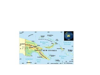
4. • The island of New Guinea is divided politically into roughly equal halves across a
north-south line:
• The western portion of the island located west of 141°E longitude, (except for a
small section of territory to the east of the Fly Riverwhich belongs to Papua New
Guinea) was formerly a Dutch colony, the Dutch East Indies, and after the Dutch
New Guinea Disputeis now two Indonesian provinces:
– West Papua with Manokwari as its capital.
– Papua with the city of Jayapura as its capital.
• The eastern part forms the mainland of Papua New Guinea, which has been an
independent country since 1975. It was formerly theTerritory of Papua and New
Guinea governed by Australia, consisting of the Trust Territory of New
Guinea (northeastern quarter, formerly German New Guinea), and the Territory of
Papua (southeastern quarter). The country consists of four regions:
– Papua, consisting of Western, Gulf, Central, Oro (Northern) and Milne Bay provinces.
– Highlands, consisting of Southern Highlands, Hela Province, Jiwaka Province, Enga
Province, Western Highlands, Simbu and Eastern Highlands provinces.
– Momase, consisting of Morobe, Madang, East Sepik and Sandaun (West Sepik) provinces.
– Islands, consisting of Manus, West New Britain, East New Britain and New
Ireland provinces, and the Bougainville Autonomous Province.