1. AN
ABSTRACT
OF
THE
THESIS
OF
William
C.
Clark
for
the
degree
of
Master
of
Science
in
Geography
presented
on
September
1,
2011.
Title:
Road
Networks,
Timber
Harvest,
and
the
Spread
of
Phytophthora
Root
Rot
Infestations
of
Port-‐Orford-‐cedar
in
Southwest
Oregon.
Abstract
approved:
Julia
A.
Jones
Phytophthora
lateralis
is
the
causal
agent
of
cedar
root
rot,
a
fatal
forest
pathogen
whose
principal
host
is
Chamaecyparis
lawsoniana
(Port-‐Orford-‐cedar),
a
predominantly
riparian-‐restricted
endemic
tree
species
of
ecological,
economical,
and
cultural
importance
to
coastal
Oregon
and
California.
Local
scale
distribution
of
P.
lateralis
is
thought
to
be
associated
with
timber
harvest
and
road-‐building
disturbances.
However,
knowledge
of
the
landscape-‐scale
factors
that
contribute
to
successful
invasions
of
P.
lateralis
is
also
important
for
effective
land
management
of
Port-‐Orford-‐cedar.
P.
lateralis
is
able
to
infest
in
wet
conditions
via
stream
networks
(zoospore)
and
dry
conditions
via
road
networks
(resting
spore).
This
study
tested
the
hypothesis
that
vehicles
spread
P.
lateralis
by
relating
its
distribution
to
traffic
intensive,
anthropogenic
disturbances
(i.e.
a
road
network,
timber
harvest)
over
a
31-‐yr
period
in
a
3,910-‐km2
portion
of
the
Rogue
River-‐Siskiyou
National
Forest
in
the
Siskiyou
Mountains
of
Oregon.
Indices
of
road
disturbance
(presence/absence,
configuration,
length,
density,
road-‐stream
network
connectivity)
and
timber
harvest
(presence/absence,
area,
density,
frequency)
were
related
to
locations
of
infested
cedar
populations
from
a
USFS
survey
dataset
using
a
geographic
information
system
(GIS).
About
40%
of
934
7th-‐field
catchments
were
infested
with
the
pathogen.
Total
road
length
of
the
study
site
was
5,070
km;
maximum
road
density
was
8.2
km/km2
and
averaged
1.6
km/km2
in
roaded
catchments
(n
=
766).
Timber
activities
extracted
17,370
ha
(2,338
cutting
units)
of
forest
across
509
catchments;
345
catchments
were
cut
≥
twice.
Maximum
harvest
density
was
0.92
km2/km2
(x¯ˉ
=
0.04).
Both
road
networks
and
timber
harvest
patchworks
were
significantly
2. related
to
cedar
root
rot
heterogeneity.
Chi-‐squared
contingency
tables
showed
that
infestation
rates
were
2.2
times
higher
in
catchments
with
roads
compared
to
roadless
catchments
and
1.4
times
higher
in
catchments
with
road-‐stream
intersections
compared
to
those
that
were
unconnected.
Infestation
was
twice
as
likely
in
catchments
with
both
harvest
and
road
presence
than
road
presence
alone.
Single-‐variable
logistic
regression
showed
that
a
one
percent
increase
in
harvest
density
increased
infestation
odds
25%
and
a
one-‐unit
(km/km2)
increase
in
road
density
increased
infestation
odds
80%.
Road
and
stream
network
configuration
was
also
important
to
pathogen
distribution:
1)
uninfested
catchments
are
most
likely
to
be
spatially
removed
from
infested,
roaded
catchments,
2)
only
11%
of
287
roaded
catchments
downstream
of
infested,
roaded
catchments
were
uninfested,
and
3)
only
12%
of
319
catchments
downstream
of
infested
catchments
were
uninfested.
Road
networks
and
timber
harvest
patchworks
appear
to
reduce
landscape
heterogeneity
by
providing
up-‐catchment
and
down-‐catchment
access
to
host
populations
by
linking
pathogenic
materials
to
the
stream
network.
Timber
harvest
data
suggest
that
while
infestation
risk
to
Port-‐Orford-‐cedar
populations
remains
high,
management
policies
may
have
curbed
infestation
risk
in
timber-‐harvested
catchments;
if
this
is
a
result
of
specific
P.
lateralis
mitigation
policies
adopted
in
the
late
1980’s
or
broader,
region-‐wide
conservation
policies
(i.e.
the
Northwest
Forest
Plan)
is
yet
unclear.
4. ROAD
NETWORKS,
TIMBER
HARVEST,
AND
THE
SPREAD
OF
PHYTOPHTHORA
ROOT
ROT
INFESTATIONS
OF
PORT-‐ORFORD-‐CEDAR
IN
SOUTHWEST
OREGON
by
William
C.
Clark
A
THESIS
Submitted
to
Oregon
State
University
in
partial
fulfillment
of
the
requirements
for
the
degree
of
Master
of
Science
Presented
September
1,
2011
Commencement
June
2012
5. Master
of
Science
thesis
of
William
C.
Clark
presented
on
September
1,
2011.
APPROVED:
Major
Professor,
representing
Geography
Chair
of
the
Department
of
Geosciences
Dean
of
the
Graduate
School
I
understand
that
my
thesis
will
become
part
of
the
permanent
collection
of
Oregon
State
University
libraries.
My
signature
below
authorizes
release
of
my
thesis
to
any
reader
upon
request.
William
C.
Clark,
Author
6. ACKNOWLEDGEMENTS
Nothing
is
isolated
from
its
environment,
including
this
thesis
–
I
am
indebted
to
my
whole
community.
Thank
you
to
Dr.
Julia
A.
Jones,
a
patient
and
pragmatic
mentor.
Thank
you,
also,
to
friends,
family,
and
cohort
but
especially:
Autumn
A.
Carlsen
Elizabeth
A.
Clark.
7. TABLE
OF
CONTENTS
Page
1
INTRODUCTION .......................................................................................................................................1
2
METHODS....................................................................................................................................................4
2.1
STUDY
SITE ...........................................................................................................................................4
2.2
DATA......................................................................................................................................................5
2.3
HYPOTHESES ........................................................................................................................................6
2.4
SPATIAL
DATA
ANALYSIS....................................................................................................................7
2.5
DISTURBANCE
METRICS................................................................................................................... 11
3
RESULTS................................................................................................................................................... 16
3.1
NETWORK
DISTURBANCE................................................................................................................ 16
3.2
PATCHWORK
DISTURBANCE ........................................................................................................... 16
3.3
LANDSCAPE
AND
NETWORK
PATTERN.......................................................................................... 17
3.3.1
Road
network
configuration...............................................................................................17
3.3.2
Stream
network
configuration...........................................................................................18
3.3.3
Road/stream
network
connectivity.................................................................................19
3.4
LOGISTIC
REGRESSION ..................................................................................................................... 19
4
DISCUSSION ............................................................................................................................................ 42
4.1
ERRORS
AND
BIAS
IN
ANALYSIS...................................................................................................... 42
4.2
EFFECTS
OF
NETWORKS
AND
NETWORK
CONFIGURATION ....................................................... 43
4.4
EFFECTS
OF
PATCHWORKS.............................................................................................................. 46
5
CONCLUSIONS........................................................................................................................................ 53
BIBLIOGRAPHY ......................................................................................................................................... 54
APPENDICES............................................................................................................................................... 58
APPENDIX
A.
CHI-‐SQUARED
LOOK-‐UP
TABLE..................................................................................... 59
APPENDIX
B.
HISTOGRAMS
FOR
CONTINUOUS
VARIABLES. ............................................................. 60
APPENDIX
C.
CORRELATION
REGRESSIONS
FOR
CONTINUOUS
VARIABLES. .................................. 64
APPENDIX
D.
SPATIAL
AUTOCORRELATION
TEST
OF
CATCHMENT
ROAD
STATUS....................... 72
APPENDIX
E.
RR-‐SNF
BIAS
ASSESSMENT........................................................................................... 73
8. LIST
OF
FIGURES
Figure
Page
FIGURE
1.
STUDY
SITE.................................................................................................................................. 13
FIGURE
2.
SOUTHWEST
OREGON
LAND
OWNERSHIP.............................................................................. 14
FIGURE
3.
SOUTHWEST
OREGON
ROAD
NETWORK................................................................................ 15
FIGURE
4.
CATCHMENTS
IN
THE
RR-‐SNF................................................................................................ 32
FIGURE
5.
ROGUE
RIVER-‐SISKIYOU
NF
SURVEY. .................................................................................... 33
FIGURE
6.
CATCHMENT
ROAD
STATUS...................................................................................................... 34
FIGURE
7.
CATCHMENT
CEDAR
ROOT
ROT
STATUS................................................................................. 35
FIGURE
8.
CATCHMENT
ROAD
DENSITY. ................................................................................................... 36
FIGURE
9.
TIMBER
HARVEST
DATA............................................................................................................ 37
FIGURE
10.
TIMBER
HARVEST
DENSITY
MAP........................................................................................... 38
FIGURE
11.
TIMBER
HARVEST
FREQUENCY
FOR
THE
RR-‐SNF. ........................................................... 39
FIGURE
12.
STREAM
NETWORK
CONFIGURATION................................................................................... 40
FIGURE
13.
ROAD-‐STREAM
INTERSECTIONS............................................................................................ 41
FIGURE
14.
SCHEMATIC
OF
A
BRANCHING
HEIRARCHY-‐TYPE
ROAD
NETWORK. ............................... 51
FIGURE
15.
ROAD
PRISM
SCHEMATIC........................................................................................................ 52
9. LIST
OF
TABLES
Table
Page
TABLE
2.1.
EXAMPLE
CONTINGENCY
TABLE...............................................................................................8
TABLE
2.2.
TABLE
NOTATION........................................................................................................................8
TABLE
2.3.
CATCHMENT
CODE
LOOK-‐UP
TABLE..................................................................................... 11
TABLE
3.1.
THE
SPATIAL
RELATIONSHIP
BETWEEN
THE
ROAD
NETWORK
AND
THE
RR-‐SNF...... 21
TABLE
3.2.
EFFECT
OF
CATCHMENT
ROAD
STATUS
ON
INFESTATION
STATUS.................................. 21
TABLE
3.3.
TIMBER
HARVEST
SUMMARY. ................................................................................................ 22
TABLE
3.4.
EFFECT
OF
TIMBER
HARVEST
FREQUENCY
ON
CATCHMENTS
INFESTATIONS............... 23
TABLE
3.5.
EFFECT
OF
TIMBER
HARVEST
ON
THE
NUMBER
OF
CATCHMENTS
WITH
INFESTATIONS.
................................................................................................................................................................ 24
TABLE
3.6.
EFFECT
OF
TIMBER
HARVEST
AND
ROADS
ON
CATCHMENTS
INFESTATIONS................ 24
TABLE
3.7.
TEMPORAL
ANALYSIS
OF
INFESTATION
RATES
BASED
ON
HARVEST
PERIOD................ 25
TABLE
3.8.
EFFECT
OF
ROAD
CONFIGURATION
ON
CATCHMENT
INFESTATION
STATUS.................. 25
TABLE
3.9.
EFFECT
OF
ADJACENCY
TO
UNINFESTED/ROADED
CATCHMENTS................................... 26
TABLE
3.10.
EFFECT
OF
ADJACENCY
TO
INFESTED/ROADLESS
CATCHMENTS.................................. 26
TABLE
3.11.
EFFECT
OF
ADJACENCY
TO
UNINFESTED/ROADLESS
CATCHMENTS............................. 27
TABLE
3.12.
EFFECT
OF
ADJACENCY
TO
INFESTED/ROADED
CATCHMENTS. .................................... 27
TABLE
3.13.
EFFECT
OF
THE
STREAM
NETWORK
ON
DOWNSTREAM
CATCHMENT
INFESTATIONS.
................................................................................................................................................................ 28
TABLE
3.14.
SPATIAL
RELATIONSHIP
BETWEEN
THE
ROAD
AND
STREAM
NETWORKS................... 29
TABLE
3.15.
EFFECT
OF
ROAD-‐STREAM
INTERSECTIONS
ON
THE
NUMBER
OF
INFESTED
CATCHMENTS....................................................................................................................................... 29
TABLE
3.16.
SUMMARY
DATA
OF
SINGLE-‐VARIABLE
ALTERNATIVE
MODELS.................................... 30
TABLE
3.17.
SUMMARY
DATA
OF
MULTIVARIATE
ALTERNATIVE
MODELS......................................... 31
10. LIST
OF
APPENDIX
FIGURES
Figure
Page
FIGURE
16.
CATCHMENT
AREA
AND
DRAINAGE
DENSITY
HISTOGRAMS............................................. 60
FIGURE
17.
ROAD
LENGTH
AND
DENSITY
HISTOGRAMS. ....................................................................... 61
FIGURE
18.
TIMBER
HARVEST
AREA
AND
DENSITY
HISTOGRAMS........................................................ 62
FIGURE
19.
ROAD-‐STREAM
INTERSECTION
DENSITY
HISTOGRAMS..................................................... 63
FIGURE
20.
COLLINEARITY
ANALYSIS
OF
LN-‐TRANSFORMED
CATCHMENT
AREA............................. 64
FIGURE
21.
COLLINEARITY
ANALYSIS
OF
LN-‐TRANSFORMED
DRAINAGE
DENSITY........................... 65
FIGURE
22.
COLLINEARITY
ANALYSIS
OF
LN-‐TRANSFORMED
ROAD
LENGTH. ................................... 66
FIGURE
23.
COLLINEARITY
ANALYSIS
OF
LN-‐TRANSFORMED
ROAD
DENSITY. .................................. 67
FIGURE
24.
COLLINEARITY
ANALYSIS
OF
LN-‐TRANSFORMED
HARVEST
AREA................................... 68
FIGURE
25.
COLLINEARITY
ANALYSIS
OF
LN-‐TRANSFORMED
HARVEST
DENSITY............................. 69
FIGURE
26.
COLLINEARITY
ANALYSIS
OF
LN-‐TRANSFORMED
ROAD-‐STREAM
INTERSECTION
DENSITY................................................................................................................................................ 70
FIGURE
28.
MORAN’S
I
TEST
OUTPUT
FROM
ARCGIS............................................................................ 72
11. LIST
OF
APPENDIX
TABLES
Table
Page
TABLE
1C.
SUMMARY
DATA
OF
COLLINEARITY. ...................................................................................... 71
TABLE
1E.
CONTINGENCY
TABLE
COMPARING
ROAD
STATUS
AND
SURVEY
STATUS........................ 73
TABLE
2E.
CONDITIONAL
PROBABILITY
RESULTS
FOR
THE
RR-‐SNF................................................. 73
TABLE
3E.
SUMMARY
OF
POWER
ANALYSIS
FROM
SELECTED
STATISTICAL
TESTS........................... 74
TABLE
4E.
ANALYSIS
OF
COINCIDENCE
BETWEEN
PORT-‐ORFORD-‐CEDAR
AND
ROADS
ON
A
CATCHMENT
BASIS.............................................................................................................................. 74
12. Road
Networks,
Timber
Harvest,
and
the
Spread
of
Phytophthora
Root
Rot
Infestations
of
Port-‐Orford-‐cedar
in
Southwest
Oregon
1
Introduction
Landscape
heterogeneity
is
the
result
of
processes
operating
at
many
spatial
and
temporal
scales
and
is
closely
linked
to
landscape
function
(Forman
&
Godron
1986).
In
the
Pacific
Northwest,
much
of
the
forested
ecosystem
exists
in
varying
states
of
disturbance
and
recovery
from
timber
harvest.
Timber
harvest
is
a
complex
disturbance
producing
both
patches
of
harvested
land
and
a
road
network
to
access
the
resource.
Most
timber
harvest
patches
on
public
forest
lands
in
the
Pacific
Northwest
are
small,
high-‐severity,
disturbances
semi-‐regularly
distributed
in
the
landscape
in
both
space
and
time.
The
associated
road
system
in
contrast,
is
a
larger-‐
scale,
linearly
branching,
permanent
network
that
fragments
the
landscape
into
a
mosaic
of
forest
patches.
Together,
timber
harvest
patchworks
and
road
networks
alter
the
heterogeneity
of
forest
structure
and
may
alter
functions
within
it.
In
particular,
timber
harvest
patchworks
and
road
networks
may
influence
the
relationship
between
Phytophthora
lateralis
and
its
host,
Chamaecyparis
lawsoniana
(Port-‐Orford-‐cedar),
in
forests
of
the
Siskiyou
Mountains,
Oregon.
Port-‐Orford-‐cedar
is
the
largest
tree
species
of
the
Cupressaceae
(Cypress)
family
and
is
endemic
to
the
Coast
Range,
Siskiyou
and
Klamath
Mountains
of
Oregon
and
northern
California
(Zobel
et
al.
1982,
Imper
1981;
Zobel
&
Hawk
1980).
Port-‐
Orford-‐cedar
is
often
limited
to
stream
margins,
areas
with
near-‐surface
groundwater,
or
moist
soils
(Imper
1981;
Farjon
2005).
Port-‐Orford-‐cedar
does
not
commonly
form
pure
stands,
but
occurs
in
mixed
coniferous
forests
dominated
by
Douglas
fir
(Pseudotsuga
menziesii)
with
components
of
western
redcedar
(Thuja
plicata),
western
hemlock
(Tsuga
heterophylla),
Pacific
madrone
(Arbutus
menziesii),
and
Sitka
spruce
(Picea
sitchensis)
(Farjon
2005).
Wood
from
Port-‐Orford-‐cedar
has
been
in
commercial
demand
since
Europeans
“discovered”
it
in
the
early
19th-‐
century
and
is
among
the
world’s
most
commercially
valuable
conifers
(Port
Orford
Cedar
Products
Company
1929;
Hansen
et
al.
2000).
13.
2
Phytophthora
lateralis
is
a
non-‐native,
soil-‐borne,
forest
pathogen
and
the
causal
agent
of
cedar
root
rot
disease,
which
was
first
reported
as
a
pathogen
of
Port-‐
Orford-‐cedar
in
the
Coast
Range
of
Oregon
in
1952
(Trione
1957).
The
origin
of
cedar
root
rot
is
unconfirmed,
but
it
is
believed
the
pathogen
was
introduced
from
Asia
or
Europe
on
ornamental
nursery
stock
(Zobel
et
al.
1982).
Although
it
has
been
observed
as
a
pathogen
on
other
species,
Port-‐Orford-‐cedar
is
its
principal
host
(DeNitto
1991;
Betlejewski
et
al.
2003;
Murray
&
Hansen
1997).
There
is
no
known
cure,
and
immunity
has
not
yet
been
discovered
in
Port-‐Orford-‐cedar,
supporting
the
hypothesis
that
cedar
root
rot
is
non-‐native
(Oh
2005;
Hansen
2008).
Port-‐Orford-‐
cedar
trees
usually
survive
less
than
four
years
after
infection
by
P.
lateralis
(Jules
et
al.
2002;
Hansen
et
al.
2000).
P.
lateralis
is
an
Oomycete,
a
water
mold
more
closely
related
to
algae
than
fungus,
whose
life
cycle
takes
place
in
a
wetted
soil
matrix
environment.
Depending
on
its
life
stage,
cedar
root
rot
is
able
to
spread
in
water
or
survive
dry
conditions.
Two
stages
of
the
cedar
root
rot
life
cycle
are
important
to
its
functional
distribution
among
Port-‐Orford-‐cedar
populations:
the
motile
zoospore
and
the
immobile
resting
spore
(chlamydospore)
(Hansen
2008).
The
zoospore
is
biflagellate
and
can
only
infest
downstream
Port-‐Orford-‐cedar
populations
and
those
within
the
wetted
soil
matrix
(Hansen
et
al.
2000).
Conversely,
the
resting
spore
is
resistant
to
dry
conditions,
giving
the
pathogen
the
ability
to
survive
throughout
a
heterogeneous
landscape.
In
favorable
conditions,
resting
spores
can
germinate
into
zoospores
or
mycelium;
a
relatively
small
amount
of
inoculum
is
needed
to
infect
a
new
host
tree
(Betlejewski
et
al.
2003).
Previous
studies
of
spatial
patterns
of
cedar
root
rot
have
suggested
that
it
is
inadvertently
transported
in
infested
soil
or
plant
material
by
traffic
along
forest
roads
and
from
roads
to
streams
(Roth
et
al.
1987;
Jules
et
al.
2002;
Betlejewski
et
al.
2003;
Kauffman
&
Jules
2006).
An
extensive
road
network
was
constructed
to
support
accelerated
timber
harvest
in
the
Pacific
Northwest
in
the
mid-‐20th-‐century.
The
US
Forest
Service
has
monitored
the
spatial
patterns
of
spread
of
cedar
root
rot
14.
3
in
southwestern
Oregon
since
1964
(Betlejewski
et
al.
2003).
However,
no
studies
have
related
the
spatial
patterns
of
road
networks
and
timber
harvest
to
the
spatial
pattern
of
spread
of
cedar
root
rot
over
a
landscape-‐scale
in
southwest
Oregon.
The
primary
objective
of
this
study
is
to
examine
how
the
heterogeneity
of
landscape
elements
affects
the
distribution
pattern
of
a
non-‐native
forest
pathogen
as
measured
by
infestation.
To
test
the
hypothesis
that
traffic
spreads
Phytophthora
lateralis,
this
study
examines
the
spatial
configuration
of
traffic-‐intensive,
anthropogenic
disturbance
(i.e.
road
networks,
timber
harvest)
and
its
relationship
to
the
distribution
of
cedar
root
rot
and
Chamaecyparis
lawsoniana
over
the
period
of
1969
to
2000
(primarily
1986-‐1994)
in
a
3,910-‐km2
portion
of
the
Rogue
River-‐
Siskiyou
National
Forest
(RR-‐Siskiyou
NF)
in
the
Siskiyou
Mountains
of
Oregon.
This
study
addressed
the
following
questions:
1. How
are
spatial
patterns
of
cedar
root
rot
infestations
of
Port-‐Orford-‐cedar
related
to
road
networks
and
timber
harvest?
2. How
are
spatial
patterns
of
cedar
root
rot
infestations
of
Port-‐Orford-‐cedar
related
to
stream
networks?
3. How
are
spatial
patterns
of
cedar
root
rot
infestations
of
Port-‐Orford-‐cedar
related
to
connectivity
of
road
networks
with
stream
networks?
15.
4
2
Methods
2.1
Study
site
The
study
site
is
a
391,100-‐ha
(3,910-‐km2)
area
comprising
the
Gold
Beach,
Powers,
and
Wild
Rivers
Ranger
Districts
of
the
RR-‐Siskiyou
NF
at
the
center
of
Port-‐Orford-‐
cedar’s
natural
range
(Figure
1).
Federally
managed
forests
(USDA
Forest
Service
[USFS]
and
Bureau
of
Land
Management
[BLM])
constitute
a
large
proportion
of
Port-‐Orford-‐cedar’s
range;
the
study
site
is
nearly
entirely
public
land
(Figure
2).
There
are
approximately
5,070
km
of
roads
in
the
study
site
(Figure
3).
Elevation
across
the
study
site
ranges
from
3
to
2,146
m
above
sea
level.
Port-‐Orford-‐cedar
is
a
key
component
of
the
local
ecology.
Over
much
of
its
range,
parent
materials
are
ultramafic
(Imper
1981).
Ultramafic
soils
are
uncommon
and
have
a
distinct
geochemistry
to
which
few
plants
have
adapted
(Alexander
2007).
Port-‐Orford-‐cedar
is
the
defining
(sometimes
sole)
overstory
species
of
43
plant
associations
in
Oregon
and
California.
Thirty
rare,
threatened
and
otherwise
protected
plant
species
are
found
within
these
communities
and
11
are
known
to
only
occur
with
Port-‐Orford-‐cedar
(Betlejewski
et
al.
2003).
Port-‐Orford-‐cedar
is
also
culturally
significant.
The
Karuk
and
Hupa
of
California
used
Port-‐Orford-‐cedar
as
the
main
building
material
for
their
“living
homes”
and
sweathouses
(Roth
et
al.
1987).
Before
its
own
decline,
Port-‐Orford-‐cedar
was
a
common
substitute
for
the
declining
hinoki
(C.
obtusa),
revered
by
the
Japanese
for
its
spiritual
importance.
In
the
20th-‐century,
timber
production
was
a
principal
economic
driver
for
economies
of
southwestern
Oregon.
Although
Douglas
fir
was
the
primary
species
of
harvest
by
volume,
Port-‐Orford-‐cedar
was
a
very
high-‐value
timber
($5,400-‐12,000/
thousand
board
feet),
at
times
reaching
≤10x
the
commercial
value
of
Douglas
fir
(Zobel
et
al.
1982;
Betlejewski
et
al.
2003).
Port-‐Orford-‐cedar
harvest
peaked
in
the
1940’s
at
60
million
board
feet
annually
(Zobel
et
al.
1982).
During
the
early
19th-‐
century,
Port-‐Orford-‐cedar
was
used
for
a
wide
array
of
products,
from
specialty
to
ordinary:
aircraft
bodies,
venetian
blinds,
battery
separators,
cabinetry,
phone
poles,
16.
5
bridge
and
ferry
decking,
ornamental
veneers,
and
turpentine
(Port
Orford
Cedar
Products
Company
1929).
Harvest
of
Port-‐Orford-‐cedar
declined
starting
in
the
1960’s
as
availability
declined
(Zobel
et
al.
1982).
General
timber
harvest
was
further
curtailed
when
the
Northwest
Forest
Plan
(1994)
established
forest
reserve
areas
in
federally
managed
forest
lands.
2.2
Data
Data
on
Port-‐Orford-‐cedar
infestation
were
obtained
from
the
USFS
(Dorena
Genetic
Resource
Center,
USDA
Forest
Service,
Cottage
Grove,
Oregon,
USA).
Surveys
of
Port-‐
Orford-‐cedar
populations
in
the
Gold
Beach,
Powers,
and
Wild
Rivers
Ranger
Districts
of
the
RR-‐Siskiyou
NF
have
been
ongoing
since
1964
(Betlejewski
et
al.
2003).
Presence
and
absence
of
cedar
root
rot
infections
(pathogen
effects
on
individual
hosts)
have
been
recorded
and
entered
into
a
GIS
in
the
vector
data
model
(polygons)
by
the
USFS
to
record
the
extent
of
infestation
(pathogen
invasion
of
a
host
population);
point
data
are
not
available.
The
survey
was
not
exhaustive:
areas
within
the
study
site
lacking
Port-‐Orford-‐cedar
were
not
surveyed.
This
study
uses
a
subset
of
the
RR-‐Siskiyou
NF
data
extending
from
1969
to
2000
(primarily
1986-‐
1994)
consisting
of
3,910
polygons
of
≥3,910
observations
(hereafter
referred
to
as
RR-‐SNF).
Most
of
the
observations
took
place
in
catchments
with
roads;
sampling
bias
is
addressed
in
Section
4.1.
The
RR-‐SNF
is
housed
in
an
ArcInfo
(version
9.3.0.1770,
Environmental
Systems
Research
Institute
[ESRI],
Redlands,
California,
USA)
file
geodatabase
at
the
USDA
Dorena
Genetic
Resource
Center
in
Cottage
Grove,
Oregon.
Several
survey
methods
are
included
in
the
RR-‐SNF:
roadside
surveys,
timber
cruise
data,
stand
exams,
and
aerial
photography
interpretation;
aerial
photographic
methods
were
only
used
in
the
Powers
Ranger
District
(Denton
2004).
Detailed
metadata
about
the
number
of
observations
used
by
the
USFS
to
create
each
polygon
and
data
collection
methods
have
not
been
found.
Cedar
root
rot
infection
can
be
visually
detected
during
most
stages
allowing
for
effective
field-‐based
surveys.
Early
detection
relies
on
diagnosing
loss
of
foliar
turgidity.
Inspecting
the
inner
bark
for
brown,
rotted
cambium
further
corroborates
17.
6
cedar
root
rot
presence.
Once
girdled,
foliar
discoloration
begins.
Early
foliar
discoloration
may
be
a
difficult
diagnostic
because
Port-‐Orford-‐cedar
has
a
naturally
broad
range
of
coloration,
but
late
discoloration
becomes
more
obvious
as
needles
begin
to
brown;
within
two
years
of
death
defoliation
occurs
(Trione
1957).
In
many
cases,
opportunistic
insect
infestations,
facilitated
by
the
pathogen,
are
the
proximal
cause
of
tree
death
(Hansen
2008).
Regional
catchment
and
stream
network
data
were
obtained
from
the
Environmental
Protection
Agency-‐US
Geological
Survey
joint
data
project,
the
National
Hydrography
Dataset
Plus
(NHDPlus;
http://www.horizon-‐systems.com/nhdplus/).
The
RR-‐SNF
data
were
examined
at
the
7th-‐field
level
(Hydrologic
Unit
Code
14)
since
that
is
the
management
unit
used
for
Port-‐Orford-‐cedar
(Denton
2004).
Road
network
data
were
obtained
from
a
BLM
dataset
(1:24,000
scale).
Timber
harvest
data
were
extracted
from
a
Landsat
change
detection
dataset
created
by
the
Laboratory
for
Applications
of
Remote
Sensing
in
Ecology
(LARSE,
Corvallis,
Oregon,
USA;
http://www.fsl.orst.edu/larse/).
The
harvest
data
extend
from
1972
to
2005;
the
data
were
truncated
to
2000
to
coincide
with
the
RR-‐SNF.
The
LARSE
harvest
data
are
parsed
into
six
time
periods:
1972-‐1977;
1977-‐1984;
1984-‐1988;
1988-‐1992;
1992-‐1996;
1996-‐2000.
This
dataset
will
not
be
able
to
capture
the
true
harvest
frequency
within
a
catchment.
Rather,
it
will
capture
the
number
of
periods
that
harvest
events
took
place
between
1972-‐2000;
this
is
a
limitation
of
the
source
data.
The
LARSE
dataset
and
analyses
of
relationships
with
timber
harvest
are
restricted
to
Oregon.
2.3
Hypotheses
Several
spatially
explicit
tests
were
conducted
to
examine
the
hypothesis
that
vehicles
spread
P.
lateralis
infestations:
H1. If
traffic
is
a
pathogen
vector,
then
there
will
be
a
positive
relationship
between
roads
and
infestation.
18.
7
H2. If
traffic
is
a
pathogen
vector,
then
there
will
be
positive
relationships
between
road
length
and
density
and
infestation
because
they
measure
increased
disturbance
and
infestation
opportunity.
H3. If
infestation
spreads
via
road
network
(resting
spore),
then
it
will
be
rare
to
observe
uninfested/roaded
catchments
adjacent
to
infested/roaded
catchments
and
rare
to
observe
infested/roadless
catchments
adjacent
to
uninfested/roadless
catchments
but
common
to
observe
infested/roaded
catchments
adjacent
to
other
infested/roaded
catchments.
H4. If
infestation
spreads
via
stream
network
(zoospore),
then
catchments
downstream
to
infested
catchments
are
likely
to
be
infested.
H5. If
the
pathogen
can
travel
both
the
road
and
stream
networks,
then
there
will
be
a
positive
relationship
between
road-‐stream
connections
and
infestation.
H6. If
traffic
is
a
pathogen
vector,
then
there
will
be
a
positive
relationship
between
timber
harvest
and
infestation
because
harvest
activities
are
vehicle
intensive.
H7. If
traffic
is
a
pathogen
vector,
then
there
will
be
positive
relationships
between
harvest
area,
density,
and
frequency
and
infestation
because
they
present
increased
disturbance
and
infestation
opportunity.
2.4
Spatial
data
analysis
Geographic
data
analysis
was
conducted
using
ArcInfo
version
10.1.0.3200
(ESRI,
Redlands,
California,
USA).
Statistical
analysis
utilized
Excel
for
Mac
version
12.2.9
(Microsoft,
Redmond,
Washington,
USA)
and
R
statistical
software
version
1.40
GUI
for
Mac
OS
X
(The
R
Foundation
for
Statistical
Computing).
Statistical
power
was
analyzed
with
G*Power
version
3.0.0
(Faul
et
al.
2007).
Statistical
analyses
tested
how
the
presence
of
cedar
root
rot
(response
variable;
based
on
the
RR-‐SNF)
was
related
to
the
presence
and
density
of
road
networks,
stream
networks,
and
timber
harvest.
Statistical
methods
included
contingency
tables
(cross
tabulation)
with
the
Pearson
chi-‐squared
statistic
(X2),
conditional
probability,
and
logistic
(logit)
regression
analysis.
19.
8
Contingency
tables
(e.g.
Table
2.1)
were
used
to
test
relationships
between
binary
response
variables
and
a
dependent
variable.
The
null
hypothesis
(H0)
of
a
contingency
table
is
that
the
response
variable
(e.g.
infestation
status)
is
independent
of
the
condition
variable
(e.g.
road
status).
Since
the
data
tested
in
this
study
are
spatially
explicit,
rejection
of
H0
indicates
a
spatial
pattern
other
than
random
between
the
response
and
condition
variables.
The
contingency
table
uses
the
X2
test
to
compare
observed
to
expected
counts.
Expected
counts
are
1)
calculated
under
the
assumption
that
H0
is
true
using
Equation
1
and
2)
compared
to
observed
counts
using
Equation
2
(Christensen
1997).
This
analysis
follows
the
notations
used
by
Christensen
(1997)
outlined
in
Table
2.2:
for
a
table
with
I
rows
and
J
columns,
observed
values
have
notation
nij,
I
=
1,
2…i
and
J
=
1,
2…j.
Larger
tables
incorporate
expected
values
(mij)
into
the
same
table
and
use
the
same
subscript
notations
as
Table
2.2.
Table
2.1.
Example
contingency
table.
This
contingency
table
has
two
binary
variables,
infestation
status
and
road
status,
and
tests
for
independence
between
them.
Observed
Expected
Road
status
Road
status
Infestation
status
roadless
roaded
∑
Infestation
status
roadless
roaded
∑
uninfested
135
434
569
uninfested
102
467
569
infested
33
332
365
infested
66
299
365
∑
168
766
934
168
766
934
Table
2.2.
Table
notation.
The
notation
becomes
important
when
identifying
specific
contributions
to
the
X2:
e.g.
in
Table
2.1
n11
=
135
and
m11
=
102.
Columns
1
2
∑
1
n11
n12
n1:
Rows
2
n21
n22
n2:
∑
n:1
n:2
n::
Expected
counts
(m)
were
determined
using
Equation
1.
This
example
calculates
m
for
position
n11
of
Table
2.2:
m11
=
n:1
(n1:/
n::);
(Equation
1)
20.
9
and
X2
was
computed
using:
X2
=
€
i =1 j =1
(nij − mij )2
mij
J
∑
I
∑ ;
(Equation
2)
Where:
nij
=
the
observed
value
of
the
cell
mij
=
the
expected
value
of
the
cell.
The
calculated
X2
was
compared
to
the
critical
chi-‐squared
value
table
(χ2,
df,
p-value;
Appendix
A).
Degrees
of
freedom
(df)
were
calculated
using
(Ramsey
&
Schafer
1997):
(r
–
1)
*
(c
–
1).
(Equation
3)
Where:
r
=
the
number
of
rows
in
the
observation
table
c
=
the
number
of
columns
in
the
observation
table.
The
H0
was
rejected
if,
and
only
if,
the
calculated
X2
exceeded
the
critical
χ2.
H0
was
rejected
at
the
following
significance
levels:
very
strong
(p
≤
0.001),
strong
(p
=
0.010),
moderate
(p
=
0.025),
slight
(p
=
0.050),
very
slight
(p
=
0.100),
and
not
significant
(p
>
0.100).
Contingency
tables
were
constructed
to
test
the
relationships
between:
roads
and
infestation,
harvest
and
infestation,
harvest
frequency
and
infestation,
road
and
stream
network
configuration
and
infestation,
and
road-‐stream
intersections
and
infestation.
Logit
regressions
were
run
using
R
software.
Logit
regression
(π)
is
a
model
for
response
variables
of
binomial
distribution
that
results
in
the
log
odds
probability
that
a
particular
response
or
event
(e.g.
that
pathogen
infestation)
will
occur
based
on
the
value
of
the
independent
variable
(e.g.
road
density):
π
=
β0
+
β1x1
+
…
+
βpxp
+
ε
(Equation
4)
Where:
β
=
parameter
value
x
=
regression
parameter
(e.g.
road
density)
ε
=
model
residual.
21.
10
Log
odds
were
then
exponentiated
for
interpretation:
Odds
that
π
=
1:
ω
=
exp(β0
+
β1x1
+
…
+
βpxp
+
ε)
(Equation
5)
Where:
π
=
1
=
positive
infestation
status
β
=
parameter
value
x
=
regression
parameter
(e.g.
road
density)
ε
=
model
residual.
Pathogen
infestation
(response
variable)
was
related
to
11
explanatory
variables
at
the
catchment
scale
using
single-‐variable
logistic
regression:
1)
catchment
area,
2)
road
presence,
3)
road
length,
4)
road
density,
5)
harvest
presence,
6)
harvest
area,
7)
harvest
density,
8)
harvest
frequency,
9)
drainage
density,
10)
road/stream
intersections,
and
11)
road-‐stream
intersection
density
(count
per
km2).
A
histogram
was
created
for
each
of
the
continuous
variables
using
R
(Appendix
B).
Catchment
area,
road
length
and
density,
harvest
area
and
density,
drainage
density,
and
road-‐stream
intersection
density
were
transformed
using
the
natural
logarithm
(base
e);
the
common
logarithm
(base
10)
was
also
tested,
but
the
natural
logarithm
resulted
in
more
normal
distributions
(Appendix
B).
A
dummy
value
of
0.0001
was
added
to
transformed
variables
before
transformation
to
preserve
zero
values.
The
11
variables
were
assessed
for
collinearity
using
simple
linear
regression
(Appendix
C).
Variables
were
also
examined
using
multivariate
logistic
regressions.
Alternative
multivariate
logistic
model
assessment
started
using
a
“rich
model”
of
all
statistically
significant
variables
regardless
of
collinearity
(the
presence/absence
metrics
were
not
addressed
in
multivariate
logistic
regression).
The
Akaike
information
criterion
(AIC),
a
metric
that
incorporates
log-‐likelihood
to
measure
relative
goodness
of
model
fit,
and
delta
(∆)
deviance,
a
metric
that
evaluates
the
fitness
of
the
model
with
a
covariate
to
the
fitness
of
the
model
without
the
covariate,
were
used
to
evaluate
model
fit
as
step-‐wise
dropterm
functions
were
used
to
eliminate
variables.
Variable
removal
ceased
when
further
removals
resulted
in
increased
AIC
or
decreased
∆
deviance.
Collinearity
results
were
then
used
to
inform
model
selection
and
prevent
22.
11
over-‐fitting
of
the
data.
Adjustments
were
made
while
maintaining
the
best
(lowest)
AIC,
greatest
significance
of
variables,
and
greatest
model
simplicity.
2.5
Disturbance
metrics
The
NHDPlus
dataset
was
used
in
a
spatial
query
(overlay)
to
identify
the
7th-‐field
catchments
included
in
the
USFS
pathogen
survey
(RR-‐SNF).
Surveyed
catchments
were
overlayed
with
the
BLM
road
layer
to
determine
road
status.
Catchments
were
coded
based
on
pathogen
absence
(0)
and
presence
(1)
and
road
absence
(0)
and
presence
(1).
The
codes
were
concatenated
to
assign
each
catchment
a
compound
binary
code
(Table
2.3).
To
test
how
road
presence
was
related
to
cedar
root
rot
infestation,
catchment
codes
were
tallied
and
tested
in
a
contingency
table.
Table
2.3.
Catchment
code
look-‐up
table.
Look-‐up
table
defining
the
compound
binary
codes
used
to
describe
the
status
of
the
surveyed
catchments
of
the
RR-‐Siskiyou
NF.
Code
Key
00
uninfested,
roadless
01
uninfested,
roaded
10
infested,
roadless
11
infested,
roaded
To
test
whether
road
length
and
density
were
related
to
cedar
root
rot
infestation,
each
was
calculated
for
the
7th-‐field
catchments
in
the
study
site.
The
BLM
road
layer
was
intersected
with
the
NHDPlus
catchment
data.
Road
lengths
(km)
were
then
joined
to
the
catchment
data
using
Spatial
Join
in
ArcGIS.
Dividing
by
catchment
area
(km2)
yielded
road
density
(km/km2).
To
test
how
cedar
root
rot
infestation
was
related
to
timber
harvest,
timber
harvest
data
were
extracted
from
the
LARSE
dataset.
The
spatial
data
coincident
to
each
time
period
were
exported
to
separate
datasets
for
pre-‐analysis.
Timber
harvest
was
measured
using
four
metrics:
1)
absence/presence,
2)
harvest
area
(km2),
3)
harvest
density
(km2/km2),
and
3)
harvest
frequency.
A
second
binary
code
was
appended
to
the
catchment
data
table
to
specify
absence
(0)
and
presence
(1)
of
harvest.
23.
12
Harvest
area,
density,
and
frequency
were
determined
for
each
catchment
in
the
study
site
using
the
Zonal
Statistics
as
Table
tool
in
ArcGIS.
To
test
how
road
status
and
cedar
root
rot
infestation
status
of
one
catchment
was
related
to
road
and
infestation
status
of
adjacent
catchments,
all
possible
pairs
of
adjacent
catchments
were
identified
and
their
infestation
and
road
status
were
queried
in
GIS.
Tallies
were
input
to
Excel
and
analyzed
in
contingency
tables.
A
test
of
independence
was
conducted
for
each
of
five
contingency
tables:
one
of
overall
adjacency
and
one
each
for
the
statuses
in
Table
2.3.
To
test
the
hypothesis
that
within
hydrologically
adjacent
catchments
(i.e.
upstream/downstream
pairs)
infestation
of
the
downstream
catchment
is
more
likely
if
the
upstream
catchment
is
also
infested
all
pairs
of
hydrologically
adjacent
catchments
were
spatially
queried
in
GIS.
Tallies
were
input
to
Excel
and
analyzed
in
contingency
tables.
To
test
how
road-‐stream
connections
were
related
to
cedar
root
rot
infestation,
points
where
roads
crossed
streams
were
identified
using
GIS.
A
culvert
inventory
does
not
exist
for
the
RR-‐Siskiyou
NF.
Instead,
a
spatial
overlay
of
geometric
intersections
between
the
road
and
stream
networks
was
computed
in
GIS.
The
analysis
resulted
in
net-‐net
nodes,
an
indication
of
the
road-‐stream
network
connectivity
of
each
catchment
sub-‐network.
A
third
binary
code
was
appended
to
roaded
catchments
(codes:
01
and
11)
indicating
absence
(0)
and
presence
(1)
of
road-‐stream
intersections.
24.
13
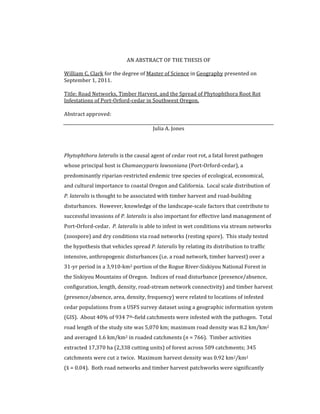
FIGURE
1.
STUDY
SITE.
Shown
are
the
extents
of
the
USFS
pathogen
survey
(1969-‐2000),
the
Rogue
River-‐Siskiyou
NF,
and
Port-‐Orford-‐cedar’s
natural
range.
The
range
is
approximate
and
delineated
using
Port-‐Orford-‐cedar
breeding
data
created
by
the
USFS.
25.
14
FIGURE
2.
SOUTHWEST
OREGON
LAND
OWNERSHIP.
The
study
site
is
contained
within
the
Rogue
River-‐Siskiyou
NF,
specifically
the
Gold
Beach,
Powers,
and
Wild
Rivers
Ranger
Districts.
The
study
site
is
approximately
391,000
ha
(3,100
km2).
Port-‐Orford-‐cedar’s
range
is
50%
federally
managed.
26.
15
FIGURE
3.
SOUTHWEST
OREGON
ROAD
NETWORK.
There
are
5,070
km
of
roads
in
the
study
site.
The
Kalmiopsis
Wilderness
Area
is
a
72,800
ha
(728
km2)
largely
roadless
area
in
the
southwest
portion
of
the
study
site.
27.
16
3
Results
3.1
Network
disturbance
The
cedar
root
rot
survey
(RR-‐SNF)
spans
934
7th-‐field
catchments
(Figure
4)
representing
~3,910
km2
of
the
RR-‐Siskiyou
NF
(Figure
5).
Mean
catchment
area
was
4.2
km2
(max
=
33.7;
σ
=
3.6).
Pathogen
presence
was
recorded
in
647
(17%)
observations.
Of
the
934
catchments,
766
(82%)
have
roads
(Table
3.1;
Figure
6)
and
365
(39%)
were
infested
with
cedar
root
rot
as
of
2000
(Figure
7).
Infestation
at
the
catchment
scale
was
strongly
positively
associated
with
the
presence
of
roads
(p
<
0.001,
X2
=
32.5,
df
=
1;
Table
3.2).
Overall,
43%
(332/766)
of
catchments
with
roads
but
only
20%
(33/168)
of
catchments
without
roads
had
infestations.
Catchments
with
roads
were
2.2
times
more
likely
to
be
infested
than
catchments
without
roads.
For
the
study
site
(n
=
934),
mean
catchment
road
length
was
5.4
km
(range:
0-‐44.8;
σ
=
6.9)
and
mean
road
density
was
1.3
km/km2
(range:
0-‐8.2
km/km2;
σ
=
1.2;
Figure
8).
For
roaded
catchments
(n
=
766),
mean
road
length
was
6.6
km
(σ
=
7.1)
and
mean
road
density
was
1.6
km/km2
(σ
=
1.0).
3.2
Patchwork
disturbance
From
1972-‐2000,
17,370
ha
(173.7
km2;
4%)
of
the
study
site
were
harvested;
2,338
harvest
units
were
cut
over
509
(54%)
catchments
(Figure
9;
Table
3.3).
For
the
study
site
(n
=
934),
mean
timber
harvest
area
was
18.6
ha
per
catchment
(range:
0-‐
367;σ=
40.5)
and
mean
harvest
density
was
0.04
km2/km2
(range:
0-‐0.92;σ=
0.08).
Mean
harvest
area
in
harvested
catchments
(n
=
509)
was
34.1
ha
(σ=
43.4)
and
mean
harvest
density
was
0.07
km2/km2
(σ=
0.08;
Figure
10).
Catchments
on
average
experienced
2.1
harvest
events;
345
catchments
were
harvested
≥
twice
and
62
were
harvested
≥
four
times
(Figure
11;
Table
3.4).
Only
109
of
425
(26%)
catchments
with
no
timber
harvest
were
infested
with
cedar
root
rot,
but
256
of
509
28.
17
(50%)
catchments
with
timber
harvest
were
infested
(Table
3.5).
Infestation
was
positively
associated
with
timber
harvest
within
a
catchment
(p
<
0.001,
X2
=
86.7,
df
=
1);
catchments
with
harvest
were
twice
as
likely
to
be
infested.
Harvest
frequency
was
strongly
positively
related
to
infestation
(p
<
0.001,
X2
=
64.4,
df
=
4).
However,
the
X2
was
dominated
by
the
individual
statistic
for
zero
harvest
frequency;
when
zero
harvest
frequency
is
excluded
from
analysis,
there
is
no
statistically
significant
relationship
between
harvest
frequency
and
infestation
status
(X2
=
2.3,
df
=
3).
Nearly
all
catchments
with
timber
harvest
also
had
roads;
only
21
catchments
with
harvest
had
no
roads.
The
association
of
timber
harvest
with
cedar
root
rot
was
examined
for
roaded
catchments
only
(n
=
766)
(Table
3.6).
Only
79
of
278
(28%)
roaded
catchments
with
no
harvest
activities
were
infested,
whereas
253
of
488
(52%)
catchments
with
harvest
were
infested;
infestations
were
twice
as
frequent
in
catchments
with
both
roads
and
harvest
compared
to
those
with
roads
only
(p
<
0.001,
X2
=
39.6,
df
=
1).
Infestation
rates
for
timber
harvest
periods
were
similar
prior
to
1992
and
ranged
from
47%
(78
of
166)
to
56%
(196
of
351;
Table
3.7).
After
1992,
infestation
rate
dropped
to
0%
(of
27)
between
1992-‐1996
and
6%
(2
of
33)
between
1996-‐2000:
catchments
that
were
harvested
prior
to
1992
were
significantly
more
likely
to
be
infested
in
2000
than
those
that
were
harvested
after
1992.
The
majority
(76%
[141
of
186])
of
catchments
that
were
harvested
twice
were
done
so
by
1988,
whereas
only
41%
(40
of
97)
of
catchments
harvested
thrice
were
done
so
by
1988.
3.3
Landscape
and
network
pattern
3.3.1
Road
network
configuration
A
total
of
4,736
catchment
neighbor
pairs
were
coded
into
Excel
(x¯ˉ
=
5.0
adjacencies
per
catchment;σ=
1.8);
2,368
pairs
were
unique.
The
infestation
and
road
status
of
a
catchment
was
highly
associated
with
those
of
its
neighbors
(p
<
0.001,
X2
=
1,714,
df
=
9;
Table
3.8).
Like-‐status
neighbors
(i.e.
00-‐00,
01-‐01,
10-‐10,
and
11-‐11
pairs)
29.
18
comprised
85%
of
the
X2
indicating
strong
spatial
clumpiness
within
the
data.
This
is
corroborated
by
a
Moran’s
I
spatial
autocorrelation
test
(Appendix
D);
roaded/infested
and
unroaded/uninfested
catchments
were
highly
spatially
autocorrelated.
Uninfested
catchments
adjacent
to
infested/roaded
catchments
were
observed
more
rarely
than
expected
if
their
distribution
had
been
random
(361
observed
instances
versus
749
expected;
Table
3.8).
There
was
a
very
strong
relationship
between
the
status
of
uninfested/roaded
(p
<
0.001,
X2
=
36.9,
df
=
1)
and
infested/roadless
catchments
(p
<
0.001,
X2
=
14.7,
df
=
1)
and
the
status
of
their
adjacent
catchments
(Tables
3.9
and
3.10).
There
were
far
fewer
infested/roadless
catchments
adjacent
to
uninfested/roaded
catchments
than
expected
(X2
=
23.1
of
36.9
[63%];
Table
3.9).
Uninfested/roadless
catchments
were
adjacent
to
infested/roadless
catchments
more
frequently
than
expected
(X2
=
6.1
of
14.7
[41%];
Table
3.10).
Infestation
status
of
uninfested/roadless
catchments
(p
<
0.05,
X2
=
1.6,
df
=
1)
and
infested/roaded
catchments
(p
<
0.05;
X2
=
0.8,
df
=
1)
was
less
strongly
related
to
the
road
and
infestation
status
of
their
neighbors
(Tables
3.11
and
3.12).
3.3.2
Stream
network
configuration
Of
the
934
catchments
in
the
study
site,
485
(52%)
were
headwater
catchments
with
only
downstream
neighbors;
184
(38%)
headwater
catchments
were
infested.
A
total
of
792
pairs
of
catchments
were
hydrologically
connected
in
the
sense
that
one
was
a
tributary
of
the
other
(Figure
12;
Table
3.13).
Infested
catchments
tend
to
be
downstream
of
other
infested
catchments:
281
of
319
(88%)
catchments
downstream
of
infested
catchments
were
infested,
whereas
only
61
of
473
(13%)
catchments
downstream
of
uninfested
catchments
were
infested.
Catchments
downstream
of
roaded
catchments
were
more
commonly
infested
(304
of
645;
47%)
than
catchments
downstream
of
roadless
catchments
(38
of
147;
26%).
Notably,
uninfested/roaded
catchments
were
never
observed
downstream
of
infested/roadless
catchments.
30.
19
3.3.3
Road/stream
network
connectivity
Mean
drainage
density
of
the
NHDPlus
data
layers
was
0.85
km/km2
(range:
0.04
–
7.9;
σ
=
0.64).
A
total
of
758
road-‐stream
intersections
occur
in
the
study
site
(Figure
13).
Infested
catchments
had
33%
more
road-‐stream
intersections
per
catchment
on
average
than
uninfested
catchments
(Table
3.14).
The
road
network
did
not
intersect
the
stream
network
in
409
(53%)
of
the
766
roaded
catchments
(Table
3.15),
and
these
catchments
were
less
likely
to
be
infested
(149/409;
36%)
than
catchments
with
road-‐stream
intersections
(183/357;
51%).
The
presence
of
road-‐
stream
intersections
in
a
roaded
catchment
increases
the
relative
risk
of
infestation
by
1.4
times
compared
to
roaded
catchments
without
intersections
and
2.6
times
compared
to
roadless
catchments.
3.4
Logistic
regression
Collinearity
was
observed
between
some
of
the
11
variables
tested;
r2
reached
0.71
(Appendix
C).
In
simple
logistic
regression
roads,
road
length,
road
density,
road-‐
stream
intersections,
harvest,
and
harvest
frequency
were
very
strongly
related
to
infestation
(p
<
0.001)
and
drainage
density,
harvest
area,
and
harvest
density
were
strongly
related
to
infestations
(p
<
0.01);
catchment
area
and
road-‐stream
intersection
density
were
not
statistically
significantly
related
to
infestations
(Table
3.16).
The
strength
of
the
relationship
between
road
and
harvest
density
can
be
seen
when
graphically
displayed
(Figure
15).
Density
metrics
were
given
more
attention
since
inferences
from
density
metrics
can
be
most
easily
applied
to
other
case
studies.
The
multivariate
rich
model
began
using
six
explanatory
variables
and
yielded
an
AIC
=
353.9
(Table
3.17).
It
was
the
intent
to
use
recursive
dropterms
procedures
to
remove
variables.
However,
only
one
application
of
the
dropterm
function
was
necessary
before
subsequent
applications
increased
AIC.
The
dropterm
procedure
removed
harvest
frequency
and
resulted
in
a
five-‐variable
model:
drainage
density,
harvest
area,
and
harvest
frequency,
which
reduced
AIC
to
353.7.
Based
on
their
31.
20
greater
model
output
p-‐values,
harvest
density
(instead
of
harvest
area)
and
road
length
(instead
of
road
density)
were
removed
from
the
model
to
prevent
over-‐
fitting
caused
by
collinearity.
The
AIC
of
this
model
rose
to
356.3.
The
interaction
between
drainage
density
and
road
density
reduced
AIC
while
increasing
∆
deviance.
The
final
model
(Model
no.
4)
for
the
log
odds
of
an
infestation
(π):
π
=
-‐12.4
+
5.6D
+
1.1H
+
0.4R
–
0.5D*H
(Equation
6)
Where:
D
=
drainage
density
(km/km2);
H
=
harvest
area
(km2);
R
=
road
density
(km/km2).
32.
21
Table
3.1.
The
spatial
relationship
between
the
road
network
and
the
RR-‐SNF.
Most
catchments
(82%
of
934)
have
a
road
within
them
and
of
those,
332
(43%)
are
infested
with
cedar
root
rot.
Code
Key
Count
∑
00
uninfested/roadless
135
10
infested/roadless
33
165
01
uninfested/roaded
434
11
infested/roaded
332
766
Table
3.2.
Effect
of
catchment
road
status
on
infestation
status.
The
X2
indicates
that
the
null
hypothesis
should
be
rejected:
infestation
and
roads
are
dependent.
Road
status
Table
position
(ob
–
eb)2
/
eb
roadless
roaded
∑
n11
10.4
Infection
status
observed
expected
observed
expected
n21
16.2
uninfested
135
102
434
467
569
n12
2.3
infested
33
66
332
299
365
n22
3.6
∑
168
168
766
766
934
X2
32.5
***
***
p
<
0.001,
df
=
1
33.
22
Table
3.3.
Timber
harvest
summary.
Summary
data
of
harvest
disturbance
in
the
RR-‐Siskiyou
NF
study
site
during
the
period
of
the
survey.
Catchments
were
subject
to
a
mean
of
2.1
harvest
events
and
4.5
units
between
1972
and
2000.
Harvest
No.
of
Units
No.
of
Catchments
Harvest
Area
(ha)
1972-‐1977
539
261
3245
1977-‐1984
842
351
7401
1984-‐1988
504
246
3624
1988-‐1992
331
166
2543
1992-‐1996
59*
27
262
1996-‐2000
63*
33
296
∑
2338
1084
^
17371
*
-
some
harvest
units
cross
multiple
7th-‐field
catchments.
^
-‐
Of
this
only
509
unique
catchments
were
harvested.
34.
23
Table
3.4.
Effect
of
timber
harvest
frequency
on
catchments
infestations.
The
X2
indicates
that
the
null
hypothesis
should
be
rejected.
Thus,
the
infestation
status
of
roaded
catchments
depends
on
the
number
of
harvest
events
that
occurred
within
that
catchment.
Catchments
with
2
harvest
events
had
significantly
higher
proportions
of
infestations
compared
to
those
with
1,
3,
or
4+
harvest
events.
Catchment
by
harvest
frequency
Table
position
(ob
–
eb)2
/
eb
Number
of
harvest
events
in
a
catchment
n11
12.6
0
1
2
3
4-‐6
∑
n21
19.6
Catchment
status
o
e
o
e
o
e
o
e
o
e
n12
2.2
uninfested
316
259
85
10
0
84
11
3
53
59
31
38
569
n22
3.5
infested
109
166
79
64
102
73
44
38
31
24
365
n13
7.6
∑
425
164
186
97
62
934
n23
11.8
n14
0.6
n24
1.0
n15
1.2
o
=
observed
n25
1.9
e
=
expected
X2
62.0
***
***
p
<
0.001,
df
=
4
35.
24
Table
3.5.
Effect
of
timber
harvest
on
the
number
of
catchments
with
infestations.
The
X2
statistic
indicates
a
strong
relationship
between
infection
status
and
presence
of
harvest
units.
Harvest
Status
Table
position
(ob
–
eb)2
/
eb
no
harvest
harvest
n11
15.7
Infestation
status
observed
expected
observed
expected
∑
n21
0.0
uninfested
316
253
253
255
569
n12
17.9
infested
109
163
256
163
365
n22
53.1
∑
425
509
934
X2
86.7***
***
p
<
0.001,
df
=
1
Table
3.6.
Effect
of
timber
harvest
and
roads
on
catchments
infestations.
The
X2
statistic
indicates
a
strong
relationship
between
infection
status
and
presence
of
harvest
units.
Roaded
catchment
by
harvest
presence
Harvest
status
Table
position
(ob
–
eb)2
/
eb
no
harvest
harvest
∑
cell
aa
10.9
Catchment
status
observed
expected
observed
expected
cell
ba
14.3
Uninfested/roaded
199
158
235
276
434
cell
ac
6.2
Infested/roaded
79
120
253
212
332
cell
bc
8.1
∑
278
488
766
X2
39.6
***
***
p
=
0.001,
df
=
1
36.
25
Table
3.7.
Temporal
analysis
of
infestation
rates
based
on
harvest
period.
Infestation
rates
dropped
in
the
early
1990’s;
sample
sizes
are,
however,
85-‐93%
fewer
than
those
of
the
1970’s
and
1980’s
.
Period
1972-‐1977
1977-‐1984
1984-‐1988
1988-‐1992
1992-‐1996
1996-‐2000
No.
of
harvested
catchments
261
351
246
166
27
33
No.
of
harvested
catchments
infested
146
196
117
78
0
2
Proportion
56%
56%
48%
47%
0%
6%
Table
3.8.
Effect
of
road
configuration
on
catchment
infestation
status.
The
X2
indicates
that
the
null
hypothesis
should
be
rejected.
Thus,
a
catchment’s
infection-‐road
status
is
dependent
on
that
of
its
neighbor.
Neighbor
catchment
Table
position
(ob
–
eb)2
/
eb
uninfested/
roadless
uninfested/
roaded
infested/
roadless
infested/
roaded
∑
n11
647.1
Base
catchment
o
e
o
e
o
e
o
e
n12
0.0
uninfested/roadless
193
37
196
193
29
14
41
215
459
n22
214.4
uninfested/roaded
-‐-‐
-‐-‐
802
483
19
36
320
534
1141
n13
14.4
infested/roadless
-‐-‐
-‐-‐
-‐-‐
-‐-‐
27
3
71
46
98
n23
8.1
infested/roaded
-‐-‐
-‐-‐
-‐-‐
-‐-‐
-‐-‐
-‐-‐
670
313
670
n33
184.0
∑
193
998
75
1102
2368
n14
140.6
n24
85.7
n34
13.8
o
=
observed
n44
405.4
e
=
expected
X2
1713.5
***
***
p
<
0.001,
df
=
9
37.
26
Table
3.9.
Effect
of
adjacency
to
uninfested/roaded
catchments.
The
χ2
indicates
that
the
null
hypothesis
should
be
rejected.
Thus,
the
status
of
uninfested,
roaded
catchments
is
dependent
on
the
status
of
their
neighbors.
Base
Catchment
Uninfested/roaded
Neighbor
catchment
Road
status
Table
position
(ob
–
eb)2
/
eb
Infection
status
roadless
roaded
∑
n11
7.9
observed
expected
observed
expected
n21
23.1
uninfested
196
160
802
838
998
n12
1.5
infested
19
55
320
284
339
n22
4.4
∑
215
1122
1337
X2
36.9
***
***
p
<
0.001,
df
=
1
Table
3.10.
Effect
of
adjacency
to
infested/roadless
catchments.
The
X2
indicates
the
null
hypothesis
should
be
rejected.
Thus,
the
status
of
infested,
roadless
catchments
is
dependent
on
the
status
of
their
neighbors.
Base
Catchment
Infested/roadless
Neighbor
catchment
Road
status
Table
position
(ob
–
eb)2
/
eb
Infection
status
roadless
roaded
∑
n11
6.1
observed
expected
observed
expected
n21
3.0
uninfested
29
18
19
30
48
n12
3.8
infested
27
38
71
60
98
n22
1.9
∑
56
90
146
X2
14.7
***
***
p
<
0.001,
df
=
1
38.
27
Table
3.11.
Effect
of
adjacency
to
uninfested/roadless
catchments.
The
null
hypothesis
is
not
rejected:
the
status
of
uninfested/roadless
catchments
is
independent
of
the
status
of
their
neighbors.
Base
Catchment
Uninfested/roadless
Neighbor
catchment
Road
status
Table
position
(ob
–
eb)2
/
eb
Infection
status
roadless
roaded
∑
n11
0.1
observed
expected
observed
expected
n21
0.7
uninfested
193
188
196
201
389
n12
0.1
infested
29
34
41
36
70
n22
0.7
∑
222
237
459
X2
1.6†
†
p
=
0.26,
df
=
1
Table
3.12.
Effect
of
adjacency
to
infested/roaded
catchments.
The
null
hypothesis
is
not
rejected:
the
status
of
infested/roadless
catchments
is
independent
of
the
status
of
their
neighbors.
Base
Catchment
Infested/roaded
Neighbor
catchment
Road
status
Table
position
(ob
–
eb)2
/
eb
Infection
status
roadless
roaded
∑
n11
0.5
observed
expected
observed
expected
n21
0.2
uninfested
41
37
320
324
361
n12
0.1
infested
71
75
670
666
741
n22
0.0
∑
112
990
1102
X2
0.8†
†
p
=
0.42,
df
=
1
39.
28
Table
3.13.
Effect
of
the
stream
network
on
downstream
catchment
infestations.
Uninfested
areas
are
rarely
downstream
of
infested
catchments,
but
often
downstream
of
other
uninfested
catchments.
Uninfested/roaded
catchments
are
never
observed
downstream
of
infested/roaded
catchments.
Upstream
Catchment
Status
Table
position
(ob
–
eb)2
/
eb
uninfested/
roadless
uninfested/
roaded
infested/
roadless
infested/
roaded
∑
n11
164
Downstream
Catchment
Status
o
e
o
e
o
e
o
e
n21
3
uninfested/roadless
72
18
45
56
2
5
4
45
123
n31
1
uninfested/roaded
35
47
260
148
0
13
32
118
327
n41
35
infested/roadless
3
6
6
17
12
2
17
14
38
n12
2
infested/roaded
5
44
47
137
18
12
234
110
304
n22
85
∑
115
358
32
287
792
n32
7
n42
59
n13
2
n23
13
n33
71
n43
3
n14
37
n24
63
n34
1
o
=
observed
n44
139
e
=
expected
X2
686
***
***
p
<
0.001,
df
=
9
40.
29
Table
3.14.
Spatial
relationship
between
the
road
and
stream
networks.
Catchment
status
n
Intersections
n
Per
catchment
Per
catchment
area
(km2)
uninfected,
roaded
434
367
0.85
81.6
infected,
roaded
332
391
1.18
79.8
∑
766
758
Table
3.15.
Effect
of
road-‐stream
intersections
on
the
number
of
infested
catchments.
Contingency
table
and
X2
for
the
road-‐stream
intersection
analysis.
The
X2
indicates
that
the
null
hypothesis
should
be
rejected.
Thus,
the
infection
status
of
roaded
catchments
depends
on
the
road-‐stream
intersection
status
of
that
catchment.
Intersection
status
Table
position
(ob
–
eb)2
/
eb
no
intersections
intersections
n11
3.4
Infection
status
observed
expected
observed
expected
∑
n21
4.5
uninfested
260
232
174
202
434
n12
4.0
infested
149
177
183
155
332
n22
5.2
∑
409
357
766
X2
17.1
***
***
p
<
0.001,
df
=
1
41.
30
Table
3.16.
Summary
data
of
single-‐variable
alternative
models.
Most
explanatory
variables
were
statistically
significantly
related
to
infestation
status
at
p
<
0.001.
Model
Model
Variable
Units
Log
odds
Odds
Std.
Error
z-‐value
Significance
AIC
∆
Deviance
n
1
catchment
area
km2
0.07
1.07
0.06
1.06
1253
1.2
934
2
drainage
density
km/km2
-‐0.35
0.70
0.13
-‐2.65
**
1247
7.2**
934
3
roads
(0/1)
1.14
3.13
0.21
5.50
***
1219
35.2***
934
4
road
length
km
0.34
1.41
0.06
5.61
***
1017
34.5***
766
5
road
density
km/km2
0.59
1.80
0.09
6.30
***
1002
50.4***
766
6
intersections
(0/1)
0.83
2.28
0.14
5.95
***
1218
35.8***
934
7
intersection
density
per
km2
0.04
1.04
0.06
0.64
498
0.4
357
8
harvest
(0/1)
1.08
2.93
0.14
7.57
***
1194
60.4***
934
9
harvest
area
km2
0.18
1.20
0.06
3.00
**
700
9.3**
509
10
harvest
density
km2/km2
0.22
1.25
0.07
3.26
**
699
11.0**
509
11†
harvest
variety
1
0.99
2.69
0.19
5.17
***
1197
63.1***
934
harvest
variety
2
1.26
3.52
0.18
6.82
***
harvest
variety
3
0.88
2.41
0.23
3.78
***
harvest
variety
4
1.06
2.90
0.28
3.84
***
***
p
<
0.001
**
p
<
0.01
†
as
a
categorical
variable,
harvest
frequency
outputs
one
AIC
and
∆
deviance.
42.
31
Table
3.17.
Summary
data
of
multivariate
alternative
models.
The
chosen
model
(model
no.
5)
has
the
lowest
AIC
while
retaining
a
high
∆
deviance.
The
interaction
between
drainage
density
and
harvest
area
was
only
slightly
statistically
significant
(p
<
0.05).
Model
no.
Interacting
Variables
Variables
No.
variables
AIC
∆
Deviation
Notes
1
dd,
ha,
hd,
hf,
rl,
rd
6
353.9
18.4
rich
model
2
dd,
ha,
hd,
rl,
rd
5
353.7
12.6
dropterm
selected
3
dd,
ha,
hd,
rd
4
355.2
9.1
adjusted
for
over-‐fitting
4
dd,
ha,
rd
3
356.3
6.0
adjusted
for
over-‐fitting
5
dd
*
ha
dd,
ha,
rd
3
352.6
11.6
chosen
model
6
dd
*
rd
dd,
ha,
rd
3
357.1
7.2
Variables:
dd
=
ln
of
drainage
density;
ha
=
ln
of
harvest
area;
hd
=
ln
of
harvest
density;
hf
=
harvest
frequency
(factor
variable);
rl
=
ln
of
road
length;
rd
=
ln
of
road
density.
43. 32
FIGURE
4.
CATCHMENTS
IN
THE
RR-‐SNF.
The
RR-‐SNF
consists
of
at
3,910
polygon
observations
that
span
934
7th-‐field
catchments,
an
area
~3,910
km2.
44. 33
FIGURE
5.
ROGUE
RIVER-‐SISKIYOU
NF
SURVEY.
RR-‐SNF
observations
from
1969
–
2000;
conservatively
there
are
3,910
polygons
in
the
dataset
that
correspond
to
at
least
that
many
observations.