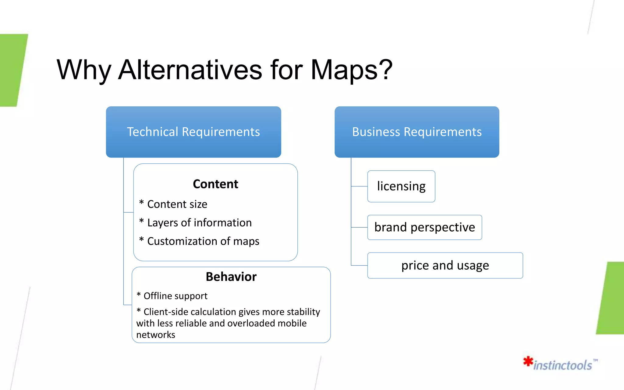
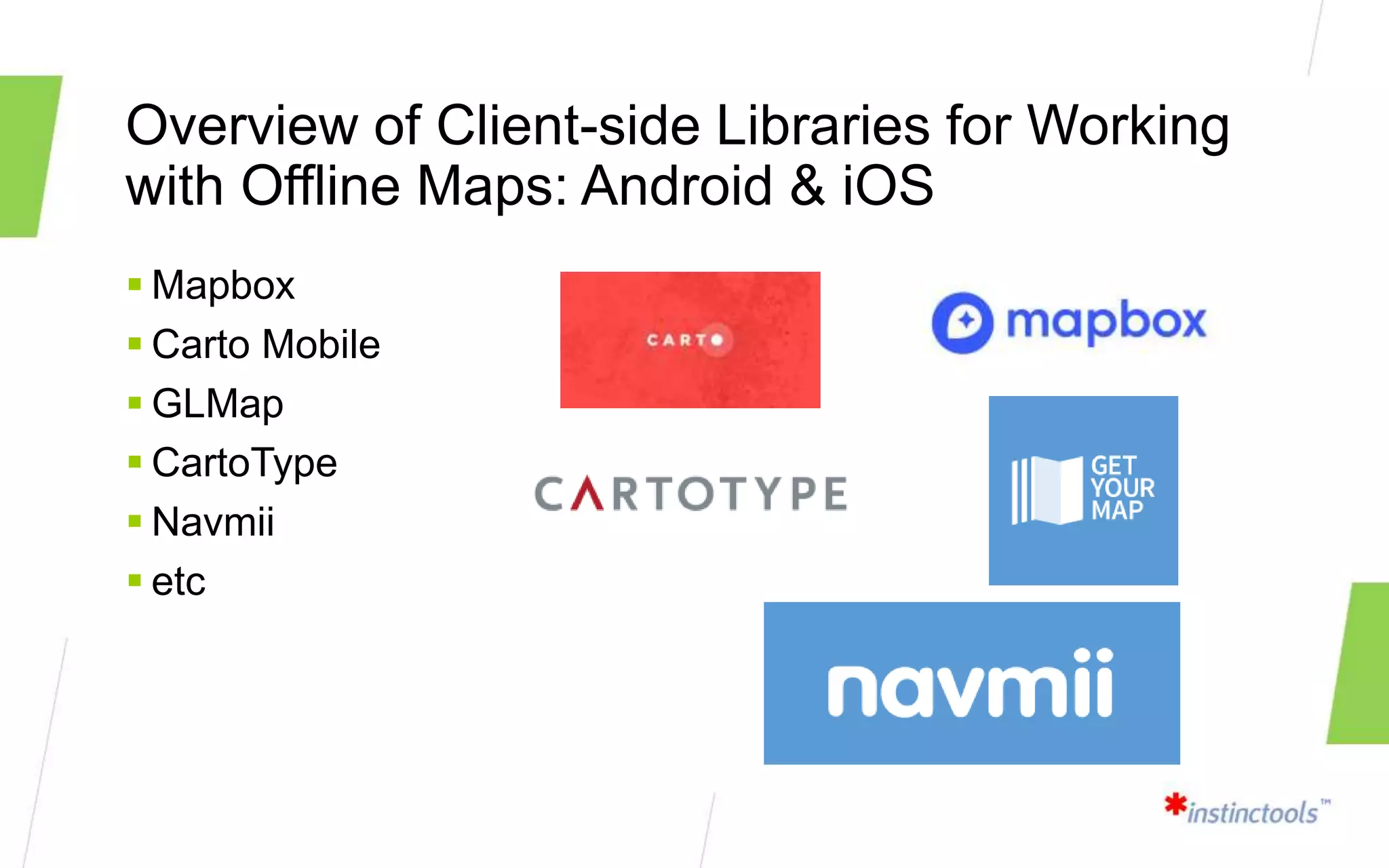
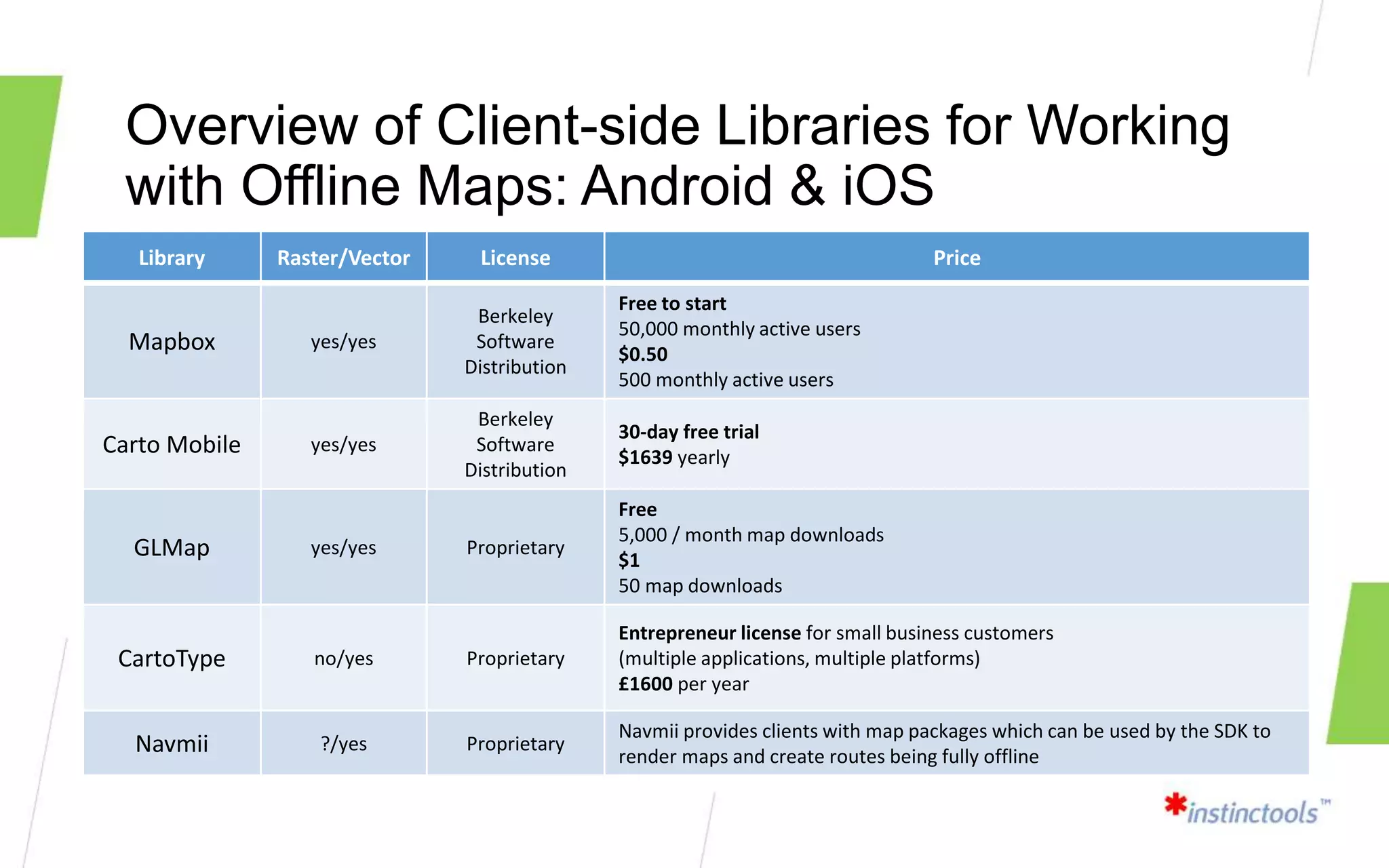
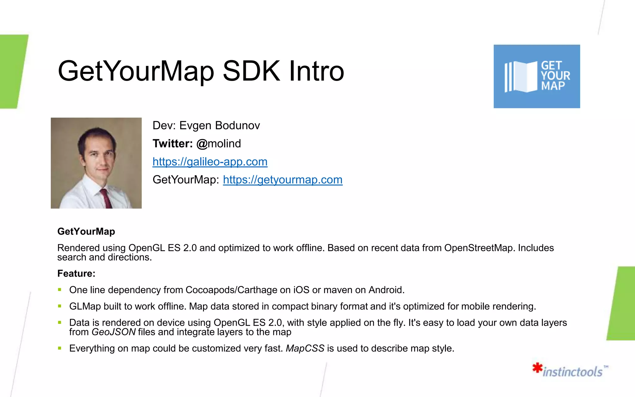
SlideShare a Scribd company logo
1 of 17
Implementing offline maps
for mobile apps
TechTalk 02/19/18
Agenda
 Is There Life Offline? Why Alternatives for Maps?
 Overview of Client-side Libraries for Working with Offline
Maps: Android & iOS
 GetYourMap SDK Intro
 Walking Through Some Code
 Demo
 Q&A
 Final
Is There Life Offline?
I need this data but my connection is awful!!!
Is There Life Offline?
I need this data but my connection is awful!!!
Is There Life Offline?
I don’t want to lose traffic on downloading data every time!
Why Alternatives for Maps?
Technical Requirements
Content
* Content size
* Layers of information
* Сustomization of maps
Behavior
* Offline support
* Client-side calculation gives more stability
with less reliable and overloaded mobile
networks
Business Requirements
licensing
brand perspective
price and usage
Overview of Client-side Libraries for
Working with Offline Maps
Overview of Client-side Libraries for Working
with Offline Maps: Android & iOS
 Mapbox
 Carto Mobile
 GLMap
 CartoType
 Navmii
 etc
Overview of Client-side Libraries for Working
with Offline Maps: Android & iOS
Library Raster/Vector License Price
Mapbox yes/yes
Berkeley
Software
Distribution
Free to start
50,000 monthly active users
$0.50
500 monthly active users
Carto Mobile yes/yes
Berkeley
Software
Distribution
30-day free trial
$1639 yearly
GLMap yes/yes Proprietary
Free
5,000 / month map downloads
$1
50 map downloads
CartoType no/yes Proprietary
Entrepreneur license for small business customers
(multiple applications, multiple platforms)
£1600 per year
Navmii ?/yes Proprietary
Navmii provides clients with map packages which can be used by the SDK to
render maps and create routes being fully offline
GetYourMap SDK Intro
Dev: Evgen Bodunov
Twitter: @molind
https://galileo-app.com
GetYourMap: https://getyourmap.com
GetYourMap
Rendered using OpenGL ES 2.0 and optimized to work offline. Based on recent data from OpenStreetMap. Includes
search and directions.
Feature:
 One line dependency from Cocoapods/Carthage on iOS or maven on Android.
 GLMap built to work offline. Map data stored in compact binary format and it's optimized for mobile rendering.
 Data is rendered on device using OpenGL ES 2.0, with style applied on the fly. It's easy to load your own data layers
from GeoJSON files and integrate layers to the map
 Everything on map could be customized very fast. MapCSS is used to describe map style.
Walking Through Some Code
 http://overpass-turbo.eu
Overpass turbo is a web based data mining tool for OpenStreetMap
It runs any kind of Overpass API query and shows the results on an interactive map.
Walking Through Some Code
Demo
Q&A
Final
E-mail: vadzim.mikalayeu@instinctools.ru
Skype: vadnik1986

More Related Content

What's hot

What's New in the ArcGIS Platform - Smart Education - Higher - AC18
What's New in the ArcGIS Platform - Smart Education - Higher - AC18What's New in the ArcGIS Platform - Smart Education - Higher - AC18
What's New in the ArcGIS Platform - Smart Education - Higher - AC18Esri UK
 
Visual Analysis With Insights and Operations Dashboard - Analytical Insights ...
Visual Analysis With Insights and Operations Dashboard - Analytical Insights ...Visual Analysis With Insights and Operations Dashboard - Analytical Insights ...
Visual Analysis With Insights and Operations Dashboard - Analytical Insights ...Esri UK
 
Switching Your Teaching to ArcGIS Pro - Smart Education - Higher - AC18
Switching Your Teaching to ArcGIS Pro - Smart Education - Higher - AC18Switching Your Teaching to ArcGIS Pro - Smart Education - Higher - AC18
Switching Your Teaching to ArcGIS Pro - Smart Education - Higher - AC18Esri UK
 
Esri Scotland Conf 2016 Web AppBuilder
Esri Scotland Conf 2016   Web AppBuilderEsri Scotland Conf 2016   Web AppBuilder
Esri Scotland Conf 2016 Web AppBuilderEsri UK
 
AppStudio for ArcGIS: The Basics - Esri FedGIS 2016
AppStudio for ArcGIS: The Basics - Esri FedGIS 2016AppStudio for ArcGIS: The Basics - Esri FedGIS 2016
AppStudio for ArcGIS: The Basics - Esri FedGIS 2016Blue Raster
 
Mobile based augmented reality
Mobile based augmented realityMobile based augmented reality
Mobile based augmented realityRaj Jani
 
Steerpath SDK presentation
Steerpath SDK presentationSteerpath SDK presentation
Steerpath SDK presentationSamuel Pullen
 
Nimble Devices Indoor Navigation Company Presentation
Nimble Devices Indoor Navigation Company PresentationNimble Devices Indoor Navigation Company Presentation
Nimble Devices Indoor Navigation Company PresentationSamuel Pullen
 

What's hot (9)

What's New in the ArcGIS Platform - Smart Education - Higher - AC18
What's New in the ArcGIS Platform - Smart Education - Higher - AC18What's New in the ArcGIS Platform - Smart Education - Higher - AC18
What's New in the ArcGIS Platform - Smart Education - Higher - AC18
 
Visual Analysis With Insights and Operations Dashboard - Analytical Insights ...
Visual Analysis With Insights and Operations Dashboard - Analytical Insights ...Visual Analysis With Insights and Operations Dashboard - Analytical Insights ...
Visual Analysis With Insights and Operations Dashboard - Analytical Insights ...
 
Switching Your Teaching to ArcGIS Pro - Smart Education - Higher - AC18
Switching Your Teaching to ArcGIS Pro - Smart Education - Higher - AC18Switching Your Teaching to ArcGIS Pro - Smart Education - Higher - AC18
Switching Your Teaching to ArcGIS Pro - Smart Education - Higher - AC18
 
Esri Scotland Conf 2016 Web AppBuilder
Esri Scotland Conf 2016   Web AppBuilderEsri Scotland Conf 2016   Web AppBuilder
Esri Scotland Conf 2016 Web AppBuilder
 
AppStudio for ArcGIS: The Basics - Esri FedGIS 2016
AppStudio for ArcGIS: The Basics - Esri FedGIS 2016AppStudio for ArcGIS: The Basics - Esri FedGIS 2016
AppStudio for ArcGIS: The Basics - Esri FedGIS 2016
 
What Esri would like to share
What Esri would like to shareWhat Esri would like to share
What Esri would like to share
 
Mobile based augmented reality
Mobile based augmented realityMobile based augmented reality
Mobile based augmented reality
 
Steerpath SDK presentation
Steerpath SDK presentationSteerpath SDK presentation
Steerpath SDK presentation
 
Nimble Devices Indoor Navigation Company Presentation
Nimble Devices Indoor Navigation Company PresentationNimble Devices Indoor Navigation Company Presentation
Nimble Devices Indoor Navigation Company Presentation
 

Similar to Offline maps for mobile developers (Android/iOS)

Simple APIs for Spatial Data (OGC API - Features)
Simple APIs for Spatial Data (OGC API - Features)Simple APIs for Spatial Data (OGC API - Features)
Simple APIs for Spatial Data (OGC API - Features)Sampo Savolainen
 
Web enabling your survey business ppt version
Web enabling your survey business ppt versionWeb enabling your survey business ppt version
Web enabling your survey business ppt versionrudy_stricklan
 
ANDROID MAPPING APPLICATION
ANDROID MAPPING APPLICATIONANDROID MAPPING APPLICATION
ANDROID MAPPING APPLICATIONcsandit
 
Volume 2-issue-6-2030-2033
Volume 2-issue-6-2030-2033Volume 2-issue-6-2030-2033
Volume 2-issue-6-2030-2033Editor IJARCET
 
Volume 2-issue-6-2030-2033
Volume 2-issue-6-2030-2033Volume 2-issue-6-2030-2033
Volume 2-issue-6-2030-2033Editor IJARCET
 
[English] Create Mobile LBS Application Using Maps API
[English] Create Mobile LBS Application Using Maps API[English] Create Mobile LBS Application Using Maps API
[English] Create Mobile LBS Application Using Maps APIGoogle Cloud Platform - Japan
 
TeleCAD-GIS Enterprise Platform Overview
TeleCAD-GIS Enterprise Platform OverviewTeleCAD-GIS Enterprise Platform Overview
TeleCAD-GIS Enterprise Platform OverviewMaksim Sestic
 
Apps & web solutions with OpenSource - Mani Singh - IMIA Asia Pacific Conference
Apps & web solutions with OpenSource - Mani Singh - IMIA Asia Pacific ConferenceApps & web solutions with OpenSource - Mani Singh - IMIA Asia Pacific Conference
Apps & web solutions with OpenSource - Mani Singh - IMIA Asia Pacific ConferenceInternational Map Industry Association
 
Introduction to mago3D, an Open Source Based Digital Twin Platform
Introduction to mago3D, an Open Source Based Digital Twin PlatformIntroduction to mago3D, an Open Source Based Digital Twin Platform
Introduction to mago3D, an Open Source Based Digital Twin PlatformSANGHEE SHIN
 
GIS Technology & Mobile Applications - MTASC 2011 Conference
GIS Technology & Mobile Applications - MTASC 2011 ConferenceGIS Technology & Mobile Applications - MTASC 2011 Conference
GIS Technology & Mobile Applications - MTASC 2011 ConferenceJim Tochterman
 
Engage 2013 - Mobile Measurement Tactics
Engage 2013 - Mobile Measurement TacticsEngage 2013 - Mobile Measurement Tactics
Engage 2013 - Mobile Measurement TacticsWebtrends
 
3 Approaches to Mobile - An A to Z Primer.
3 Approaches to Mobile - An A to Z Primer.3 Approaches to Mobile - An A to Z Primer.
3 Approaches to Mobile - An A to Z Primer.agup2009
 
Providing New Geographic Solutions to the Company
Providing New Geographic Solutions to the Company Providing New Geographic Solutions to the Company
Providing New Geographic Solutions to the Company Esri
 

Similar to Offline maps for mobile developers (Android/iOS) (20)

Simple APIs for Spatial Data (OGC API - Features)
Simple APIs for Spatial Data (OGC API - Features)Simple APIs for Spatial Data (OGC API - Features)
Simple APIs for Spatial Data (OGC API - Features)
 
Web enabling your survey business ppt version
Web enabling your survey business ppt versionWeb enabling your survey business ppt version
Web enabling your survey business ppt version
 
ANDROID MAPPING APPLICATION
ANDROID MAPPING APPLICATIONANDROID MAPPING APPLICATION
ANDROID MAPPING APPLICATION
 
Volume 2-issue-6-2030-2033
Volume 2-issue-6-2030-2033Volume 2-issue-6-2030-2033
Volume 2-issue-6-2030-2033
 
Volume 2-issue-6-2030-2033
Volume 2-issue-6-2030-2033Volume 2-issue-6-2030-2033
Volume 2-issue-6-2030-2033
 
[English] Create Mobile LBS Application Using Maps API
[English] Create Mobile LBS Application Using Maps API[English] Create Mobile LBS Application Using Maps API
[English] Create Mobile LBS Application Using Maps API
 
Location Based Services Without the Cocoa
Location Based Services Without the CocoaLocation Based Services Without the Cocoa
Location Based Services Without the Cocoa
 
TeleCAD-GIS Enterprise Platform Overview
TeleCAD-GIS Enterprise Platform OverviewTeleCAD-GIS Enterprise Platform Overview
TeleCAD-GIS Enterprise Platform Overview
 
Working with mobile app developers to enable indoor location based services
Working with mobile app developers to enable indoor location based servicesWorking with mobile app developers to enable indoor location based services
Working with mobile app developers to enable indoor location based services
 
Apps & web solutions with OpenSource - Mani Singh - IMIA Asia Pacific Conference
Apps & web solutions with OpenSource - Mani Singh - IMIA Asia Pacific ConferenceApps & web solutions with OpenSource - Mani Singh - IMIA Asia Pacific Conference
Apps & web solutions with OpenSource - Mani Singh - IMIA Asia Pacific Conference
 
Geospatial Product Watch 2015
Geospatial Product Watch 2015Geospatial Product Watch 2015
Geospatial Product Watch 2015
 
Introduction to mago3D, an Open Source Based Digital Twin Platform
Introduction to mago3D, an Open Source Based Digital Twin PlatformIntroduction to mago3D, an Open Source Based Digital Twin Platform
Introduction to mago3D, an Open Source Based Digital Twin Platform
 
Advanced Maps on Apps for Series 40
Advanced Maps on Apps for Series 40Advanced Maps on Apps for Series 40
Advanced Maps on Apps for Series 40
 
CV
CVCV
CV
 
HERE Maps for the Nokia X platform
HERE Maps for the Nokia X platformHERE Maps for the Nokia X platform
HERE Maps for the Nokia X platform
 
GIS Technology & Mobile Applications - MTASC 2011 Conference
GIS Technology & Mobile Applications - MTASC 2011 ConferenceGIS Technology & Mobile Applications - MTASC 2011 Conference
GIS Technology & Mobile Applications - MTASC 2011 Conference
 
Engage 2013 - Mobile Measurement Tactics
Engage 2013 - Mobile Measurement TacticsEngage 2013 - Mobile Measurement Tactics
Engage 2013 - Mobile Measurement Tactics
 
3 Approaches to Mobile - An A to Z Primer.
3 Approaches to Mobile - An A to Z Primer.3 Approaches to Mobile - An A to Z Primer.
3 Approaches to Mobile - An A to Z Primer.
 
Providing New Geographic Solutions to the Company
Providing New Geographic Solutions to the Company Providing New Geographic Solutions to the Company
Providing New Geographic Solutions to the Company
 
LUMIA APP LAB #16: HERE APPLICATION LAUNCHERS
LUMIA APP LAB #16: HERE APPLICATION LAUNCHERSLUMIA APP LAB #16: HERE APPLICATION LAUNCHERS
LUMIA APP LAB #16: HERE APPLICATION LAUNCHERS
 

Offline maps for mobile developers (Android/iOS)

  • 1. Implementing offline maps for mobile apps TechTalk 02/19/18
  • 2. Agenda  Is There Life Offline? Why Alternatives for Maps?  Overview of Client-side Libraries for Working with Offline Maps: Android & iOS  GetYourMap SDK Intro  Walking Through Some Code  Demo  Q&A  Final
  • 3. Is There Life Offline? I need this data but my connection is awful!!!
  • 4. Is There Life Offline? I need this data but my connection is awful!!!
  • 5. Is There Life Offline? I don’t want to lose traffic on downloading data every time!
  • 6. Why Alternatives for Maps? Technical Requirements Content * Content size * Layers of information * Сustomization of maps Behavior * Offline support * Client-side calculation gives more stability with less reliable and overloaded mobile networks Business Requirements licensing brand perspective price and usage
  • 7. Overview of Client-side Libraries for Working with Offline Maps
  • 8. Overview of Client-side Libraries for Working with Offline Maps: Android & iOS  Mapbox  Carto Mobile  GLMap  CartoType  Navmii  etc
  • 9. Overview of Client-side Libraries for Working with Offline Maps: Android & iOS Library Raster/Vector License Price Mapbox yes/yes Berkeley Software Distribution Free to start 50,000 monthly active users $0.50 500 monthly active users Carto Mobile yes/yes Berkeley Software Distribution 30-day free trial $1639 yearly GLMap yes/yes Proprietary Free 5,000 / month map downloads $1 50 map downloads CartoType no/yes Proprietary Entrepreneur license for small business customers (multiple applications, multiple platforms) £1600 per year Navmii ?/yes Proprietary Navmii provides clients with map packages which can be used by the SDK to render maps and create routes being fully offline
  • 10. GetYourMap SDK Intro Dev: Evgen Bodunov Twitter: @molind https://galileo-app.com GetYourMap: https://getyourmap.com GetYourMap Rendered using OpenGL ES 2.0 and optimized to work offline. Based on recent data from OpenStreetMap. Includes search and directions. Feature:  One line dependency from Cocoapods/Carthage on iOS or maven on Android.  GLMap built to work offline. Map data stored in compact binary format and it's optimized for mobile rendering.  Data is rendered on device using OpenGL ES 2.0, with style applied on the fly. It's easy to load your own data layers from GeoJSON files and integrate layers to the map  Everything on map could be customized very fast. MapCSS is used to describe map style.
  • 13. Walking Through Some Code  http://overpass-turbo.eu Overpass turbo is a web based data mining tool for OpenStreetMap It runs any kind of Overpass API query and shows the results on an interactive map.
  • 15. Demo
  • 16. Q&A