SlideShare a Scribd company logo
1 of 1
Build a city in SketchUp Generate the community garden and place
it in the urban environment
Build the urban environment in Unity and
generate particles to simulate the pollutant
Run the simulation in two different
environment: Urban with or without
community garden
Use ArcGIS to analyze the result with
different buffer zone
Use ArcScene to generate a 3D
visualization
Do the same for the community garden
setting
Create a 3D analysis model in SketchUp of
the analysis

More Related Content

What's hot

Google Earth Presentation
Google Earth PresentationGoogle Earth Presentation
Google Earth Presentationabc
 
Google maps intro
Google maps introGoogle maps intro
Google maps introkdafoe
 
GeoNerdsDC Presentation 2011-08-02
GeoNerdsDC Presentation 2011-08-02GeoNerdsDC Presentation 2011-08-02
GeoNerdsDC Presentation 2011-08-02Glenn Waldron
 
FOSS4G-NA 2012 : ReadyMap - OpenLayers in 3D
FOSS4G-NA 2012 : ReadyMap - OpenLayers in 3DFOSS4G-NA 2012 : ReadyMap - OpenLayers in 3D
FOSS4G-NA 2012 : ReadyMap - OpenLayers in 3DGlenn Waldron
 
GRASS GIS lightening talk at FOSS4G 2006
GRASS GIS lightening talk at FOSS4G 2006GRASS GIS lightening talk at FOSS4G 2006
GRASS GIS lightening talk at FOSS4G 2006Markus Neteler
 
visual Positioning System
visual Positioning Systemvisual Positioning System
visual Positioning SystemIlyas Arafath
 
Google map and navigation
Google map and navigation Google map and navigation
Google map and navigation Shalikram Patel
 
SeWa - Sentinel Watcher
SeWa - Sentinel WatcherSeWa - Sentinel Watcher
SeWa - Sentinel Watcherplan4all
 
inetMAPS for Google Maps
inetMAPS for Google MapsinetMAPS for Google Maps
inetMAPS for Google MapsinetSYNX
 
Depth image recognition using isomorphic graph theory
Depth image recognition using isomorphic graph theoryDepth image recognition using isomorphic graph theory
Depth image recognition using isomorphic graph theoryChristian Kehl
 

What's hot (19)

Surfer
SurferSurfer
Surfer
 
Google Earth Presentation
Google Earth PresentationGoogle Earth Presentation
Google Earth Presentation
 
Google maps intro
Google maps introGoogle maps intro
Google maps intro
 
GeoNerdsDC Presentation 2011-08-02
GeoNerdsDC Presentation 2011-08-02GeoNerdsDC Presentation 2011-08-02
GeoNerdsDC Presentation 2011-08-02
 
FOSS4G-NA 2012 : ReadyMap - OpenLayers in 3D
FOSS4G-NA 2012 : ReadyMap - OpenLayers in 3DFOSS4G-NA 2012 : ReadyMap - OpenLayers in 3D
FOSS4G-NA 2012 : ReadyMap - OpenLayers in 3D
 
Google earth
Google earthGoogle earth
Google earth
 
GRASS GIS lightening talk at FOSS4G 2006
GRASS GIS lightening talk at FOSS4G 2006GRASS GIS lightening talk at FOSS4G 2006
GRASS GIS lightening talk at FOSS4G 2006
 
visual Positioning System
visual Positioning Systemvisual Positioning System
visual Positioning System
 
Interactive Scene
Interactive SceneInteractive Scene
Interactive Scene
 
how effective is google map in businesses communication
how effective is google map in businesses communication how effective is google map in businesses communication
how effective is google map in businesses communication
 
Google map and navigation
Google map and navigation Google map and navigation
Google map and navigation
 
Google Maps
Google MapsGoogle Maps
Google Maps
 
Virtual GIS Environment
Virtual GIS EnvironmentVirtual GIS Environment
Virtual GIS Environment
 
SeWa - Sentinel Watcher
SeWa - Sentinel WatcherSeWa - Sentinel Watcher
SeWa - Sentinel Watcher
 
05 c ge graphsttp2020
05 c  ge graphsttp202005 c  ge graphsttp2020
05 c ge graphsttp2020
 
inetMAPS for Google Maps
inetMAPS for Google MapsinetMAPS for Google Maps
inetMAPS for Google Maps
 
Google map[1]
Google map[1]Google map[1]
Google map[1]
 
Depth image recognition using isomorphic graph theory
Depth image recognition using isomorphic graph theoryDepth image recognition using isomorphic graph theory
Depth image recognition using isomorphic graph theory
 
Smart city and gis
Smart city and gisSmart city and gis
Smart city and gis
 

Steps of building the simulations

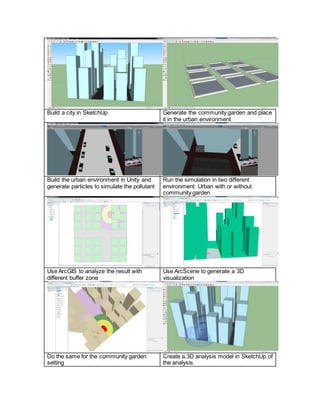
  • 1. Build a city in SketchUp Generate the community garden and place it in the urban environment Build the urban environment in Unity and generate particles to simulate the pollutant Run the simulation in two different environment: Urban with or without community garden Use ArcGIS to analyze the result with different buffer zone Use ArcScene to generate a 3D visualization Do the same for the community garden setting Create a 3D analysis model in SketchUp of the analysis