SlideShare a Scribd company logo
1
Scientific Analysis of Aesthetics
vs Safety in Wyoming
Scientific Analysis of Aesthetics vs Safety
in Wyoming
2
Scientific Analysis of Aesthetics
vs Safety in Wyoming
Table of Contents
Description Page 1
Methods Page 1
Results Page 1
Discussion Page 1-2
Maps Pages 3-4
3
Scientific Analysis of Aesthetics
vs Safety in Wyoming
Description: Wyoming is a state where there is more pristine environments rather than human
developments making it an ideal place for outdoor recreation. However with the large amounts
of backcountry hikers and skiers comes more threatening opportunities of getting lost. The
Search and Rescue team in the area could benefit greatly from the creation of a radio tower. On
the other side of the spectrum the Sierra Club and the World Wildlife Fund see the introduction
of a radio tower as destroying an aesthetically beautiful area that they say, ”should remain
forever wild”. Science can be used to make a compromise between the two making sure that
the visible impact of the towers is not as large as the benefit the search and rescue gains from
having the tower.
Methods: Data about the Gannet Peaks Area in Wyoming which includes the digitial elevation
models of the peaks in the area as well where local recreation. Next viewshed should be
calculated from the height of the highest tower to prevent ArcGIS from automatically creating a
flat viewshed rather than applying it to the various peak heights. This made it so that one could
see where the area is viewable and is not viewable in a Boolean Fashion. To input the average
height tower height which I calculated to be about 60 meters from an average of towers in the
US I added another field in the attribute table for tower layer. The attribute table also showed
quadrangle area and where each tower had a view. Next came changing the recreation layer
and tower layer from vector to raster so that they could be combined in raster calculator. Next
came reclassifying the lake layers for a value of 1. Next came multiplying the towers by the
viewshed to calculate how many towers could be viewed from each lake.
Results and Summary: The area within the quadrangle that is affected varied from tower to
tower. The highest value went up to 436241 meters while the lowest value was 43522 meters
squared. The lakes that will be affected by each individual tower would be Big Tourist lake,
Flagstone Lake, Desolation Lake, Klondike Lake, Scott Lake, Lost Pipe Lake, Stone Hammer lake,
Peak Lake, Dale Lake, Elbow Lake, Summit Lake, and Summer Ice Lake. From Lost Pipe Lake the
most towers could be seen at 3 and 2 can be seen from Scott lake and Big Tourist lake. From
the rest of the lakes that were referred to only 1can be seen as seen in the map in figure 1. As
seen in the second figure 2 Scott Lake has a view of 6 radio towers. Finally a good
recommendation for a radio tower spot would be the one located between Peak Lake and Lost
Pipe Lake.
Discussion: Overall I believe that the safety of people is more important the aesthetics that
have to be given up from building a radio tower. Tower height can be modified based on
preferences but 60 meters is generally a smaller respectable height. Also instead of building
multiple radio towers a single could be made eliminating worst scenario viewshed spots.
4
Scientific Analysis of Aesthetics
vs Safety in Wyoming
Figure 1: Shows both how many towers can be seen from each of the recreational
sites and the viewshed of each tower or where peaks are visible and where they are not
Lost Pipe
Peak Lake
Klondike
5
Scientific Analysis of Aesthetics
vs Safety in Wyoming
Figure 2: Shows how many towers can be seen from each of the recreational sites
Desolation
Scott
Big Tourist

More Related Content

Similar to Scientific Analysis of Aesthetics vs Safety in Wyoming

Chapter 2 Of Rock Engineering
Chapter 2 Of  Rock  EngineeringChapter 2 Of  Rock  Engineering
Chapter 2 Of Rock Engineering
Ngo Hung Long
 
IRJET- Design of Energy Dissipator for Khadakwasla Dam to Control the Vel...
IRJET-  	  Design of Energy Dissipator for Khadakwasla Dam to Control the Vel...IRJET-  	  Design of Energy Dissipator for Khadakwasla Dam to Control the Vel...
IRJET- Design of Energy Dissipator for Khadakwasla Dam to Control the Vel...
IRJET Journal
 
Resilient Urban Edges: Adaptive and Mitigative Strategies in Chennai
Resilient Urban Edges: Adaptive and Mitigative Strategies in Chennai Resilient Urban Edges: Adaptive and Mitigative Strategies in Chennai
Resilient Urban Edges: Adaptive and Mitigative Strategies in Chennai
Monsoon Assemblages
 
42 h08nw0011 (copy)
42 h08nw0011 (copy)42 h08nw0011 (copy)
42 h08nw0011 (copy)
RyanPaul Mandel
 
Oyster castle addition at bennett's point
Oyster castle addition at bennett's pointOyster castle addition at bennett's point
Oyster castle addition at bennett's point
MadisonSocha
 
Precise GIS Modeling of a Dam
Precise GIS Modeling of a DamPrecise GIS Modeling of a Dam
Precise GIS Modeling of a DamArmando Drain
 
Buck Lake Wildlife Map V1
Buck Lake Wildlife Map V1Buck Lake Wildlife Map V1
Buck Lake Wildlife Map V1Jason Lamberts
 
Sea Level Rise Inundation Mapping for the ART Project
Sea Level Rise Inundation Mapping for the ART ProjectSea Level Rise Inundation Mapping for the ART Project
Sea Level Rise Inundation Mapping for the ART Project
Justin Vandever
 
Analysis Of Water Balance and Its Effect on Tube well Efficiency
Analysis Of Water Balance and Its Effect on Tube well EfficiencyAnalysis Of Water Balance and Its Effect on Tube well Efficiency
Analysis Of Water Balance and Its Effect on Tube well Efficiency
IRJET Journal
 
“Analysis Of Water Balance and Its Effect on Tube well Efficiency”
“Analysis Of Water Balance and Its Effect on Tube well Efficiency”“Analysis Of Water Balance and Its Effect on Tube well Efficiency”
“Analysis Of Water Balance and Its Effect on Tube well Efficiency”
IRJET Journal
 
Restricting Hydraulic Jump Location Inside Stilling Basin for Maximum Energy ...
Restricting Hydraulic Jump Location Inside Stilling Basin for Maximum Energy ...Restricting Hydraulic Jump Location Inside Stilling Basin for Maximum Energy ...
Restricting Hydraulic Jump Location Inside Stilling Basin for Maximum Energy ...
IRJET Journal
 
Seismic Analysis for Safety of Dams
Seismic Analysis for Safety of DamsSeismic Analysis for Safety of Dams
Seismic Analysis for Safety of Dams
IOSR Journals
 
Iaetsd rf controlled sailing robot for oceanic missions
Iaetsd rf controlled sailing robot for oceanic missionsIaetsd rf controlled sailing robot for oceanic missions
Iaetsd rf controlled sailing robot for oceanic missionsIaetsd Iaetsd
 
Senior Design Project
Senior Design ProjectSenior Design Project
Senior Design Project
drpaulse
 
Record Setting: The Origins of Extreme Hail on 19 March 2018 during VORTEX-SE
Record Setting: The Origins of Extreme Hail on 19 March 2018 during VORTEX-SERecord Setting: The Origins of Extreme Hail on 19 March 2018 during VORTEX-SE
Record Setting: The Origins of Extreme Hail on 19 March 2018 during VORTEX-SE
DeanMeyer14
 
The Effect Of Global Warming On Thermohaline Circulation
The Effect Of Global Warming On Thermohaline CirculationThe Effect Of Global Warming On Thermohaline Circulation
The Effect Of Global Warming On Thermohaline Circulation
Amanda Hengel
 
#1011_Whitney_Irrigation_Pond_Dam_Hazard_and_Condition_Assessment_Report
#1011_Whitney_Irrigation_Pond_Dam_Hazard_and_Condition_Assessment_Report#1011_Whitney_Irrigation_Pond_Dam_Hazard_and_Condition_Assessment_Report
#1011_Whitney_Irrigation_Pond_Dam_Hazard_and_Condition_Assessment_ReportDavid Vitali
 
Belmont (BEA-TXV) #lithium #Nevada PPP 2018
Belmont (BEA-TXV) #lithium #Nevada PPP 2018Belmont (BEA-TXV) #lithium #Nevada PPP 2018
Belmont (BEA-TXV) #lithium #Nevada PPP 2018
Follow me on Twitter @Stockshaman
 

Similar to Scientific Analysis of Aesthetics vs Safety in Wyoming (20)

Chapter 2 Of Rock Engineering
Chapter 2 Of  Rock  EngineeringChapter 2 Of  Rock  Engineering
Chapter 2 Of Rock Engineering
 
IRJET- Design of Energy Dissipator for Khadakwasla Dam to Control the Vel...
IRJET-  	  Design of Energy Dissipator for Khadakwasla Dam to Control the Vel...IRJET-  	  Design of Energy Dissipator for Khadakwasla Dam to Control the Vel...
IRJET- Design of Energy Dissipator for Khadakwasla Dam to Control the Vel...
 
Resilient Urban Edges: Adaptive and Mitigative Strategies in Chennai
Resilient Urban Edges: Adaptive and Mitigative Strategies in Chennai Resilient Urban Edges: Adaptive and Mitigative Strategies in Chennai
Resilient Urban Edges: Adaptive and Mitigative Strategies in Chennai
 
42 h08nw0011 (copy)
42 h08nw0011 (copy)42 h08nw0011 (copy)
42 h08nw0011 (copy)
 
Oyster castle addition at bennett's point
Oyster castle addition at bennett's pointOyster castle addition at bennett's point
Oyster castle addition at bennett's point
 
Precise GIS Modeling of a Dam
Precise GIS Modeling of a DamPrecise GIS Modeling of a Dam
Precise GIS Modeling of a Dam
 
Buck Lake Wildlife Map V1
Buck Lake Wildlife Map V1Buck Lake Wildlife Map V1
Buck Lake Wildlife Map V1
 
Sea Level Rise Inundation Mapping for the ART Project
Sea Level Rise Inundation Mapping for the ART ProjectSea Level Rise Inundation Mapping for the ART Project
Sea Level Rise Inundation Mapping for the ART Project
 
Analysis Of Water Balance and Its Effect on Tube well Efficiency
Analysis Of Water Balance and Its Effect on Tube well EfficiencyAnalysis Of Water Balance and Its Effect on Tube well Efficiency
Analysis Of Water Balance and Its Effect on Tube well Efficiency
 
“Analysis Of Water Balance and Its Effect on Tube well Efficiency”
“Analysis Of Water Balance and Its Effect on Tube well Efficiency”“Analysis Of Water Balance and Its Effect on Tube well Efficiency”
“Analysis Of Water Balance and Its Effect on Tube well Efficiency”
 
Restricting Hydraulic Jump Location Inside Stilling Basin for Maximum Energy ...
Restricting Hydraulic Jump Location Inside Stilling Basin for Maximum Energy ...Restricting Hydraulic Jump Location Inside Stilling Basin for Maximum Energy ...
Restricting Hydraulic Jump Location Inside Stilling Basin for Maximum Energy ...
 
Seismic Analysis for Safety of Dams
Seismic Analysis for Safety of DamsSeismic Analysis for Safety of Dams
Seismic Analysis for Safety of Dams
 
Iaetsd rf controlled sailing robot for oceanic missions
Iaetsd rf controlled sailing robot for oceanic missionsIaetsd rf controlled sailing robot for oceanic missions
Iaetsd rf controlled sailing robot for oceanic missions
 
WRDSeminar_rmartyr
WRDSeminar_rmartyrWRDSeminar_rmartyr
WRDSeminar_rmartyr
 
Senior Design Project
Senior Design ProjectSenior Design Project
Senior Design Project
 
SUR-WIND Final Paper
SUR-WIND Final PaperSUR-WIND Final Paper
SUR-WIND Final Paper
 
Record Setting: The Origins of Extreme Hail on 19 March 2018 during VORTEX-SE
Record Setting: The Origins of Extreme Hail on 19 March 2018 during VORTEX-SERecord Setting: The Origins of Extreme Hail on 19 March 2018 during VORTEX-SE
Record Setting: The Origins of Extreme Hail on 19 March 2018 during VORTEX-SE
 
The Effect Of Global Warming On Thermohaline Circulation
The Effect Of Global Warming On Thermohaline CirculationThe Effect Of Global Warming On Thermohaline Circulation
The Effect Of Global Warming On Thermohaline Circulation
 
#1011_Whitney_Irrigation_Pond_Dam_Hazard_and_Condition_Assessment_Report
#1011_Whitney_Irrigation_Pond_Dam_Hazard_and_Condition_Assessment_Report#1011_Whitney_Irrigation_Pond_Dam_Hazard_and_Condition_Assessment_Report
#1011_Whitney_Irrigation_Pond_Dam_Hazard_and_Condition_Assessment_Report
 
Belmont (BEA-TXV) #lithium #Nevada PPP 2018
Belmont (BEA-TXV) #lithium #Nevada PPP 2018Belmont (BEA-TXV) #lithium #Nevada PPP 2018
Belmont (BEA-TXV) #lithium #Nevada PPP 2018
 

Scientific Analysis of Aesthetics vs Safety in Wyoming

  • 1. 1 Scientific Analysis of Aesthetics vs Safety in Wyoming Scientific Analysis of Aesthetics vs Safety in Wyoming
  • 2. 2 Scientific Analysis of Aesthetics vs Safety in Wyoming Table of Contents Description Page 1 Methods Page 1 Results Page 1 Discussion Page 1-2 Maps Pages 3-4
  • 3. 3 Scientific Analysis of Aesthetics vs Safety in Wyoming Description: Wyoming is a state where there is more pristine environments rather than human developments making it an ideal place for outdoor recreation. However with the large amounts of backcountry hikers and skiers comes more threatening opportunities of getting lost. The Search and Rescue team in the area could benefit greatly from the creation of a radio tower. On the other side of the spectrum the Sierra Club and the World Wildlife Fund see the introduction of a radio tower as destroying an aesthetically beautiful area that they say, ”should remain forever wild”. Science can be used to make a compromise between the two making sure that the visible impact of the towers is not as large as the benefit the search and rescue gains from having the tower. Methods: Data about the Gannet Peaks Area in Wyoming which includes the digitial elevation models of the peaks in the area as well where local recreation. Next viewshed should be calculated from the height of the highest tower to prevent ArcGIS from automatically creating a flat viewshed rather than applying it to the various peak heights. This made it so that one could see where the area is viewable and is not viewable in a Boolean Fashion. To input the average height tower height which I calculated to be about 60 meters from an average of towers in the US I added another field in the attribute table for tower layer. The attribute table also showed quadrangle area and where each tower had a view. Next came changing the recreation layer and tower layer from vector to raster so that they could be combined in raster calculator. Next came reclassifying the lake layers for a value of 1. Next came multiplying the towers by the viewshed to calculate how many towers could be viewed from each lake. Results and Summary: The area within the quadrangle that is affected varied from tower to tower. The highest value went up to 436241 meters while the lowest value was 43522 meters squared. The lakes that will be affected by each individual tower would be Big Tourist lake, Flagstone Lake, Desolation Lake, Klondike Lake, Scott Lake, Lost Pipe Lake, Stone Hammer lake, Peak Lake, Dale Lake, Elbow Lake, Summit Lake, and Summer Ice Lake. From Lost Pipe Lake the most towers could be seen at 3 and 2 can be seen from Scott lake and Big Tourist lake. From the rest of the lakes that were referred to only 1can be seen as seen in the map in figure 1. As seen in the second figure 2 Scott Lake has a view of 6 radio towers. Finally a good recommendation for a radio tower spot would be the one located between Peak Lake and Lost Pipe Lake. Discussion: Overall I believe that the safety of people is more important the aesthetics that have to be given up from building a radio tower. Tower height can be modified based on preferences but 60 meters is generally a smaller respectable height. Also instead of building multiple radio towers a single could be made eliminating worst scenario viewshed spots.
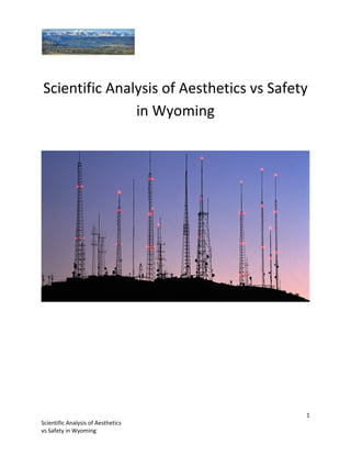
  • 4. 4 Scientific Analysis of Aesthetics vs Safety in Wyoming Figure 1: Shows both how many towers can be seen from each of the recreational sites and the viewshed of each tower or where peaks are visible and where they are not Lost Pipe Peak Lake Klondike
  • 5. 5 Scientific Analysis of Aesthetics vs Safety in Wyoming Figure 2: Shows how many towers can be seen from each of the recreational sites Desolation Scott Big Tourist