2. 2
YellowstoneNational Park:BlackandGrey
Wolf HabitatDynamics
Stefan Zdziarski
Table of Contents
Description Page 2
Methods Page 2-3
Data Table Page 4
Results Page 5
Discussion Page 5
Maps Page 6
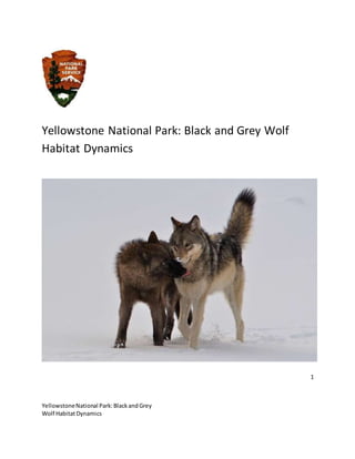
Description: The Rocky Mountain wolf (Canis lupis) once roamed from the Arctic tundra to
Mexico, however loss of habitat due to human development and extermination lead to it being
listed as an endangered species. Yellowstone National Park became a recovery area for the
3. 3
YellowstoneNational Park:BlackandGrey
Wolf HabitatDynamics
species. Since 1973 when the park originally started the reintroduction program numbers have
led to a gradual increase in the overall population size. The park is actively working to ensure
the long term viability of the species through particular research on their behaviors and pack
dynamics. This report seeks to examine a portion of the park to discover the best suitable
habitats for the wolves. Things that are considered in the data are how close the populations
are to roads, gravel pits, and lakes. Good intro, cite source of additional info
Methods: In looking for the best habitats for the wolves the data imported had to include
proximity to roads, gravel pits, snow, precipitation, wolf sightings, and elevation. When the
Yellowstone park data was imported it included areas outside the park boundary. Digital
elevation models, roads and the precipitation data stretched outside the parameters of the
study. Using the spatial analysis tool within ArcGIS I then navigated to the raster calculator.
Another issue that arose was in how the precipitation and roads layers were represented as
vector layers. This meant that if I wanted the info to stay within the borders of Yellowstone I
would have to use the Geoprocessing option within the toolbox to help clip the edges within
the vector layers. The sightings of the wolves involved both Grey and Black wolves so to make
the differentiation I had to change the symbology of the wolf sightings theme to depict these
unique values. To be able to query the data and make scientific connections within it, the data
that was originally vector such as snow and precipitation had to be switched to raster. This was
done in ArcToolbox’s conversion tools in the feature to raster option. To further be able to
work with the data I had to switch the habitat parameters to a value based off of distance from
the features that the wolves would stray from. To do this the spatial analysis tool must be used
under the Euclidean Distance option for both gravel pits and roads.
When looking at the newly transformed data, it was time to start making conclusions
about the habitats of the Black and Grey Wolves. It was important that when looking at the
wolf sightings layer that it be also connected to the other considerable factors such as
precipitation, elevation, snow and distance from gravel pits and roads. There had to be value
4. 4
YellowstoneNational Park:BlackandGrey
Wolf HabitatDynamics
points so that each wolf sighting was associated with each of the other layers mentioned
before. To do this I searched for extracted layer points in the help window. I used this setting on
every feature that was represented in the data.
The last step involved looking at the attribute tables so I could isolate the two different
wolf types. This was where I used the select by attributes option. With this I could select the
type of wolf I wanted to look for. This was where I created an ordinal ranking systembased off
of the analysis for the 5 features that were explored in this map.
Ranking System of Gray and Black Wolves
Elevation Ranking Precip Ranking Roads Ranking Gravel Ranking Snow Ranking
Black
Wolf
7825-
8000 3 0 -2 3
94.8-
2000 5
370-
2560 5 1-1.1 4
8113-
8200 5 2-3.8 1
2124.
9-
8,000 1
2560-
6700 3
1.8-
1.9 2
>8689 1 >25 5
2000-
2124.
9 3 <9154.7 1
2.8-
2.9 5
Grey
Wolf
7713-
7750 5 0 -2 3
201.2-
1000 5
162-
3000 5 .9-1 2
7770-
8000 2
2.1-
3.9 1
1,800-
3,700 2
3000-
4600 3 1.9-2 1
>8613 1 >4 5
<5551
.4 1 <8000 1 2.9-3 5
5. 5
YellowstoneNational Park:BlackandGrey
Wolf HabitatDynamics
Results and Summary: The data shows that populations of grey wolf prefer to be close to
Yellowstone River, with some signs of the black wolf nearby also. It shows that the species
usually congregate in valleys somewhat closer to roads than would be expected.
Black Wolves: The data showed that the species preferred an elevation from 8,100 to about
8,200 feet. When looking at how they respond to precipitation anything greater than 25 inches
they thrived and with snow it was about 3 inches. They prefer to be about 2000 feet from roads
and about 2,500 feet from gravel pits.
Grey Wolves: The data showed that the species preferred an elevation of about 7720 which is
somewhat lower than their subspecies relative. When responding to precipitation, they prefer
anything greater than 4 inches and with snow 3 inches. As for distance away from roads grey
wolves generally go for about 1500 feet. As for distance from gravel pits they stay at about
3,000 feet.
From this analysis it shows that the two species show different preferences when
comparing their relations to elevation, precipitation, snow, distance from roads and distance
from gravel pits. They are similar in that they tend to inhabit elevations from 7,600 to 8,100 and
also generally like to stay about the same distance from roads and gravel pits. Grey wolves tend
6. 6
YellowstoneNational Park:BlackandGrey
Wolf HabitatDynamics
to be somewhat closer to humans while black wolves are more solitary and tend to go a couple
feet higher in elevation. In creating a management strategy for these species based on this data
one could conclude that human development should not necessarily be stopped, but that at a
certain elevation, developers should be mindful of species habits.
Discussion: The data that was collected in this lab was primarily based on 4 limiting factors. So
this would make the extrapolated data related limited only to say distance from roads and
gravel pits. Instead, it may have been better to explore other aspects of human presence upon
these animals’ habitats. Maybe including information such as where hiking trails are, campsites,
or possibly even exploring populations of the prey that the wolves depend upon. Although the
data was easily acquired it’s not certain at what point in time it was taken as over temporal
time the wolves’ population has steadily grown. As more wolves are added the data essentially
becomes more accurate also.
Stefan - a good first report, need to be more specific in your methods section and work on your
tables. See comments on map below. 92/100
8. 8
YellowstoneNational Park:BlackandGrey
Wolf HabitatDynamics
Map comments:
1. More descriptive title
2. What does the color gradient add to the map? How can the reader decipher
3. Hard to see gravel pits with that color
4. Hard to see roads
5. First point symbol in the legend doesn’t have a label
6. Map elements are on top of the map, zoom out and use the white space
91/100