CMIC's Exploration Innovation Consortium, presented by François Robert and Al...
NCStatePoster
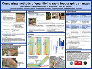
1. Comparing methods of quantifying rapid topographic changes
Sierra Melton1,2, Matthew Gonzales1,3, Rob Austin1, Rich McLaughlin1
1North Carolina State University Dept. of Crop and Soil Sciences, 2Colorado College, 3New Mexico State University
Introduction
Research Sites
Methods Conclusions
Acknowledgements
• At construction sites, land
disturbance leads to soil
erosion.
• Significant sediment loss
occurs in temporary diversion
ditches intended to direct
runoff into catchment basins.
Sediment damages water quality and ecosystem health
Eroded sediment
Harms aquatic organisms
Increases turbidity
• Reduces visibility
• Limits photosynthesis
Eroded nutrients
Eutrophication
Algal blooms
Measuring erosion in ditches
Traditional methods: Tedious and time consuming
Alternative methods: Remote sensing, photogrammetry
Less time- and labor-intensive
Research Question:
Can remote sensing methods be used to accurately
quantify sediment loss from temporary diversion ditches
and assess the effectiveness of ditches at directing runoff
into catchment basins?
Sediment and Erosion Control Research and
Education Facility (SECREF) in Raleigh, NC
Active construction site in Apex, NC
Artificial ditches
in controlled
environment
Remote sensing methods
• Light Detection and Ranging (LiDAR)
• Unmanned Aerial Vehicle (UAV) imagery
• Ground-based imagery
Traditional methods
• Physical cross-section measurements
• Total suspended sediment (TSS) measured from water samples
Computed flow paths at construction site
• Interpolated raster from UAV point cloud
• Edited digital elevation model (DEM) to
account for piping and culverts
• Filled sinks in DEM
• Calculated flow direction, accumulation
Many thanks to the NC State University Department of Crop and
Soil Science and the Basic and Environmental Soil Science Training
(BESST) REU program, especially program leader Josh Heitman
and co-leader Owen Duckworth. Thanks to Jamie Luther, Chris
Niewoehner, and Maria Polizzi for field support, as well as the North
Carolina Department of Transportation. Financial support for this
research was provided by the NSF Research Experience for
Undergraduates Project 1358938.
Contact Information:
Sierra Melton, sierra.melton@coloradocollege.edu
Calculated volume of sediment loss
• Documented ditches before and after
runoff events
• Interpolated rasters from point clouds
• Subtracted raster surfaces, multiplied by
ditch area
Monitored
unlined ditch
Method Pros Cons
LiDAR • High accuracy
• Coregistration not
required with
constant scanner
location
• Expensive
• One-sided perspective
• Difficult to transport
• User expertise
UAV
Imagery
• Comparatively
inexpensive
• Quick data collection
• Difficult to capture
fine details at high
resolution
Ground-
based
Imagery
• Inexpensive
• Minimal equipment
• Captures small area
in great detail
• Requires many
photos (~2 ft apart)
• Intensive data
processing
TSS • Physical
measurement of
sediment in water
• No spatial data
• Time-intensive (lab,
field, data processing)
LiDAR UAV Imagery Ground Imagery
SECREF
Construction Site
Ground-based Imagery
July 13 - July 21, 2016
Flow Routing
Results
-4
-3
-2
-1
0
1
2
3
4
5
LiDAR
UAV
Ground
TSS
LiDAR
UAV
Ground
TSS
VolumeSedimentLoss(ft3)
Run 1 Run 2
Volume loss: 5.12 ft3 Volume loss: 3.06 ft3 Volume loss: 2.75 ft3
0.226
-0.105
0.842
-0.648
0.286
-0.008
Sediment loss (ft) Sediment loss (ft) Sediment loss (ft)
1.27
-1.41
Sediment loss (ft)
UAV Imagery
June 13, 2016
Run 2 Run 2 Run 2
Flow
direction
Flow direction
Flow routing from UAV imagery
Promising as construction site assessment tool
• Identifying problem spots
• Documenting issues
• Directing future ditch placement
Highly precise coregistration of raster surfaces:
Essential for accurate volume change calculations
Highly visible markers needed (color, depth)
Quantifying sediment loss
• Remote sensing and photogrammetric methods enable
spatial representation of topographic changes
• UAV and ground-based imagery are low-cost, spatially
accurate alternative methods