![National Center for Earth-surface Dynamics
Short Course
Morphology,Morphodynamicsand Ecologyof MountainRivers
December 11-12,2005
2
Q
Qbf
Let denote river stage (water surface elevation) [L] and Q
denote volume water discharge [L3/T]. In the case of rivers
with floodplains, tends to increase rapidly with increasing
Q when all the flow is confined to the channel, but much
less rapidly when the flow spills significantly onto the
floodplain. The rollover in the curve defines bankfull
discharge Qbf.
(The quantities in brackets denote dimensions: here L =
length, T = time and M = mass.)
Minnesota River and
floodplain, USA, during the
record flood of 1965
THE CONCEPT OF BANKFULL DISCHARGE](data:image/gif;base64,R0lGODlhAQABAIAAAAAAAP///yH5BAEAAAAALAAAAAABAAEAAAIBRAA7)
Recommended
Recommended
More Related Content
Similar to Mountain Rivers Hydraul Geom.ppt
Similar to Mountain Rivers Hydraul Geom.ppt (20)
Recently uploaded
Recently uploaded (20)
Mountain Rivers Hydraul Geom.ppt
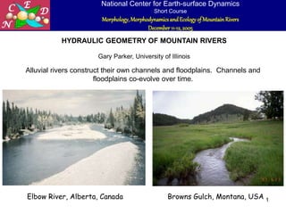
- 1. National Center for Earth-surface Dynamics Short Course Morphology,Morphodynamicsand Ecologyof MountainRivers December 11-12,2005 1 HYDRAULIC GEOMETRY OF MOUNTAIN RIVERS Gary Parker, University of Illinois Alluvial rivers construct their own channels and floodplains. Channels and floodplains co-evolve over time. Elbow River, Alberta, Canada Browns Gulch, Montana, USA
- 2. National Center for Earth-surface Dynamics Short Course Morphology,Morphodynamicsand Ecologyof MountainRivers December 11-12,2005 2 Q Qbf Let denote river stage (water surface elevation) [L] and Q denote volume water discharge [L3/T]. In the case of rivers with floodplains, tends to increase rapidly with increasing Q when all the flow is confined to the channel, but much less rapidly when the flow spills significantly onto the floodplain. The rollover in the curve defines bankfull discharge Qbf. (The quantities in brackets denote dimensions: here L = length, T = time and M = mass.) Minnesota River and floodplain, USA, during the record flood of 1965 THE CONCEPT OF BANKFULL DISCHARGE
- 3. National Center for Earth-surface Dynamics Short Course Morphology,Morphodynamicsand Ecologyof MountainRivers December 11-12,2005 3 PARAMETERS FOR BANKFULL GEOMETRY This lecture characterizes bankfull geometry in terms of the following parameters: 1. Bankfull discharge Qbf in cubic meters per second [L3/T]; 2. Bankfull channel width Bbf is meters [L]; 3. Bankfull cross-sectionally averaged channel depth Hbf [L]; 4. Down-channel slope S (meters drop per meter distance) [1]. Other parameters are defined in subsequent slides. Relations for bankfull geometry of the following form are often posited: 3 . 0 bf 4 . 0 bf bf 5 . 0 bf bf Q ~ S Q ~ H Q ~ B Bbf Hbf
- 4. National Center for Earth-surface Dynamics Short Course Morphology,Morphodynamicsand Ecologyof MountainRivers December 11-12,2005 4 BANKFULL PARAMETERS: THE RIVER AND ITS FLOODPLAIN An alluvial river constructs its own channel and floodplain. channel floodplain At bankfull flow the river is on the verge of spilling out onto its floodplain.
- 5. National Center for Earth-surface Dynamics Short Course Morphology,Morphodynamicsand Ecologyof MountainRivers December 11-12,2005 5 GRAVEL-BED AND SAND-BED RIVERS Rivers (or more specifically river reaches) can also be classified according to the characteristic size of their surface bed sediment, i.e median size Ds50 or geometric mean size Dsg. A river with a characteristic size between 0.0625 and 2 mm can be termed a sand-bed stream. Two such streams are shown below. Fly River, Papua New Guinea. Jamuna (Brahmaputra) River, Bangladesh. Image courtesy J. Imran.
- 6. National Center for Earth-surface Dynamics Short Course Morphology,Morphodynamicsand Ecologyof MountainRivers December 11-12,2005 6 GRAVEL-BED AND SAND-BED RIVERS A river with a characteristic surface size in excess of 16 mm can be termed a gravel-bed river. Here the term “gravel” is used loosely to encompass cobble- and boulder-bed streams as well. Three such streams are shown below. Genessee River, New York, USA. Raging River, Washington, USA. Rakaia River, New Zealand
- 7. National Center for Earth-surface Dynamics Short Course Morphology,Morphodynamicsand Ecologyof MountainRivers December 11-12,2005 7 GRAVEL-BED AND SAND-BED RIVERS A river with a characteristic surface size between 2 and 16 mm can be termed transitional in terms of grain size. Such streams are much less common than either sand-bed or gravel-bed streams, but can be found readily enough, particularly in basins that produce sediment from weathered granite. An example is shown to the right. Hii River, Japan. Image courtesy H. Takebayashi
- 8. National Center for Earth-surface Dynamics Short Course Morphology,Morphodynamicsand Ecologyof MountainRivers December 11-12,2005 8 GRAVEL-BED AND SAND-BED RIVERS 0 5 10 15 20 25 30 35 40 0 . 0 6 2 5 - 0 . 1 2 5 0 . 1 2 5 - 0 . 2 5 0 . 2 5 - 0 . 5 0 . 5 - 1 1 - 2 2 - 4 4 - 8 8 - 1 6 1 6 - 3 2 3 2 - 6 4 6 4 - 1 2 8 1 2 8 - 2 5 6 Grain size range in mm Number of reaches Alberta Japan Sand-bed Gravel-bed Transitiona l The diagram to the left shows the frequency of river reaches with various characteristic grain sizes within two sets, one from Alberta, Canada (Kellerhals et al., 1972) and the other from Japan (Yamamoto, 1994; Fujita et al., 1998). Note that most rivers can be classified as either gravel-bed or sand-bed.
- 9. National Center for Earth-surface Dynamics Short Course Morphology,Morphodynamicsand Ecologyof MountainRivers December 11-12,2005 9 MOUNTAIN RIVERS: ALLUVIAL VERSUS BEDROCK Mountain rivers are generally gravel-bed rivers. Not all mountain rivers, however, have a definable bankfull geometry. For example, many mountain rivers have little alluvium and considerable amounts of exposed bedrock, and are thus not free to construct their own geometry. In addition, some gravel-bed rivers have incised in recent times, and left their floodplains abandoned as terraces. Here the following case is considered: alluvial, gravel-bed mountain streams with definable floodplains. Wilson Creek, Kentucky, USA: a mountain bedrock stream. Image courtesy A. Parola
- 10. National Center for Earth-surface Dynamics Short Course Morphology,Morphodynamicsand Ecologyof MountainRivers December 11-12,2005 10 SINGLE-THREAD VERSUS MULTIPLE-THREAD (BRAIDED) MOUNTAIN RIVERS Raging River, Washington, USA: a single-thread gravel- bed river Sunwapta River, Canada: a multiple-thread (braided) gravel- bed river The case considered here is that of single-thread streams. A single-thread stream has a single definable channel, although mid-channel bars may be present. A multiple-thread, or braided stream has several channels that intertwine back and forth.
- 11. National Center for Earth-surface Dynamics Short Course Morphology,Morphodynamicsand Ecologyof MountainRivers December 11-12,2005 11 CHARACTERIZING BED SEDIMENT IN GRAVEL-BED STREAMS: MEDIAN SURFACE SIZE Ds50 Gravel-bed streams usually show a surface armor. That is, the surface layer is coarser than the substrate below. Bed sediment of the River Wharfe, U.K., showing a pronounced surface armor. Photo courtesy D. Powell. Armored surface substrate
- 12. National Center for Earth-surface Dynamics Short Course Morphology,Morphodynamicsand Ecologyof MountainRivers December 11-12,2005 12 CHARACTERIZING DOWN-CHANNEL SLOPE S Down-channel bed slope is determined from a survey of the long profile of the channel centerline. The reach chosen to determine bed slope should be long enough to average over any bars and bends in the channel, which are associated with local elevation highs and lows. A B bed elevation down-channel distance A B S plan view long profile of centerline bed elevation
- 13. National Center for Earth-surface Dynamics Short Course Morphology,Morphodynamicsand Ecologyof MountainRivers December 11-12,2005 13 MORE PARAMETERS USED TO CHARACTERIZE BANKFULL CHANNEL GEOMETRY OF SINGLE-THREAD GRAVEL-BED RIVERS In order to capture as much universality as possible, it is useful to characterize the bankfull geometry of alluvial, gravel-bed mountain streams in dimensionless form. Thus in addition to the previously-defined parameters: Qbf = bankfull discharge [L3/T] Bbf = bankfull width [L] Hbf = bankfull depth [L] S = bed slope [1] Ds50 = median surface grain size [L] the following parameters are added: = density of water [M/L3] s = material density of sediment [M/L3] R = (s/ – 1) = sediment submerged specific gravity (~ 1.65 for natural sediment) [1] g = gravitational acceleration [L/T2] = kinematic viscosity of water [L2/T]
- 14. National Center for Earth-surface Dynamics Short Course Morphology,Morphodynamicsand Ecologyof MountainRivers December 11-12,2005 14 DIMENSIONLESS PARAMETERS CHARACTERIZING CHANNEL BANKFULL GEOMETRY 5 / 2 bf 5 / 1 bf Q g H H ~ 5 / 2 bf 5 / 1 bf Q g B B ~ 2 50 s 50 s bf D gD Q Q̂ = dimensionless bankfull discharge = dimensionless bankfull depth = dimensionless bankfull width Down-channel slope S is already dimensionless.
- 15. National Center for Earth-surface Dynamics Short Course Morphology,Morphodynamicsand Ecologyof MountainRivers December 11-12,2005 15 MORE DIMENSIONLESS PARAMETERS CHARACTERIZING CHANNEL BANKFULL GEOMETRY bf bf bf bf bf gH H B Q Fr bf bf H B 50 s 50 s 50 p D gD R Re 50 s bf 50 bf D R S H S gH H B Q Cz bf bf bf bf bf = width-depth ratio at bankfull flow (dimensionless) = bankfull Froude number (dimensionless) = (estimate of) bankfull Shields number (dimensionless) = bankfull Chezy resistance coefficient (dimensionless) = particle Reynolds number (surrogate for grain size: dimensionless)
- 16. National Center for Earth-surface Dynamics Short Course Morphology,Morphodynamicsand Ecologyof MountainRivers December 11-12,2005 16 INTERPRETATION OF SOME OF THE DIMENSIONLESS PARAMETERS bf bf bf bf bf bf bf gH U gH H B Q Fr 50 s 50 s 50 p D gD R Re 50 s bf 50 bf D R S H S gH U S gH H B Q Cz bf bf bf bf bf bf bf Bankfull flow velocity Ubf = Qbf/(HbfBbf) Bankfull Froude number characterizes a ratio of momentum force to gravity force. When Froude number Fr < 1 the flow is subcritical, or tranquil: when Fr > 1 the flow is supercritical, or swift. Here where U and H are cross-sectionally- averaged flow velocity and depth, respectively. The relation can be rewritten as so that a high value of Czbf implies a low bed resistance. For the case of steady, uniform (normal) flow, the bed shear stress b is given as b = gHS where H = depth. A dimensionless measure of the ability of the flow to mobilize sediment is the Shields number, * = b/(RgD). Here denotes an estimate of value of * for bankfull flow based on a surface median size for D. Since in most cases g = 9.81 m/s2, R 1.65 and 1x10⁻⁶ m2/s, Rep50 is a surrogate for median surface grain size ~ Ds50 3/2. S gH Cz U bf bf bf 50 bf gH U/ Fr
- 17. National Center for Earth-surface Dynamics Short Course Morphology,Morphodynamicsand Ecologyof MountainRivers December 11-12,2005 17 SINGLE-THREAD MOUNTAIN GRAVEL-BED RIVERS HAVE CONSISTENT BANKFULL GEOMETRIES This is illustrated here using data from four sources: • 16 streams flowing from the Rocky Mountains in Alberta, Canada (Kellerhals et al., 1972); • 23 mountain streams in Idaho (Parker et al., 2003); • 23 upland streams in Britain (mostly Wales) (Charlton et al. 1978); • 10 reaches along the upper Colorado River, Colorado (Pitlick and Cress, 2002) (Each reach represents an average of several subreaches.) The original data for Qbf, Bbf, Hbf, S and Ds50 for each reach can be found in Excel file, ToolboxGravelBankfullData.xls.
- 18. National Center for Earth-surface Dynamics Short Course Morphology,Morphodynamicsand Ecologyof MountainRivers December 11-12,2005 18 RANGE OF PARAMETERS Among all four sets of data, the range of parameters is as given below: Bankfull discharge Qbf (in meters3/sec) 2.7 ~ 5440 Bankfull width Bbf (in meters) 5.24 ~ 280 Bankfull depth Hbf (in meters) 0.25 ~ 6.95 Channel slope S 0.00034 ~ 0.031 Surface median size Ds50 (in mm) 27 ~ 167 These ranges approximate the range of applicability of the relations in this presentation.
- 19. National Center for Earth-surface Dynamics Short Course Morphology,Morphodynamicsand Ecologyof MountainRivers December 11-12,2005 19 WHAT THE DATA SAY The four data sets tell a consistent story of bankfull channel characteristics. 0.0001 0.001 0.01 0.1 1 10 100 1.0E+02 1.0E+03 1.0E+04 1.0E+05 1.0E+06 1.0E+07 Qhat Btilde, Htilde, S Britain width Alberta width Idaho width Colorado width Britain depth Alberta depth Idaho depth Colorado depth Britain slope Alberta slope Idaho slope Colorado slope H ~ B ~ S S , H ~ , B ~ Q̂ Dimensionless width Dimensionless depth Down-channel bed slope
- 20. National Center for Earth-surface Dynamics Short Course Morphology,Morphodynamicsand Ecologyof MountainRivers December 11-12,2005 20 y = 0.3785x4E-05 y = 4.6977x0.0661 y = 0.1003x-0.3438 1.E-04 1.E-03 1.E-02 1.E-01 1.E+00 1.E+01 1.E+02 1.E+02 1.E+03 1.E+04 1.E+05 1.E+06 1.E+07 Qdim Bdimtilde, Hdimtilde, S Bdimtilde Hdimtilde S Power (Hdimtilde) Power (Bdimtilde) Power (S) 3438 . 0 0661 . 0 00004 . 0 Q̂ 1003 . 0 S , Q̂ 698 . 4 B ~ , Q̂ 3785 . 0 H ~ To a high degree of approximation, 3785 . 0 H ~ H ~ c REGRESSION RELATIONS FOR BANKFULL CHANNEL CHARACTERISTICS S , H ~ , B ~ Q̂ S B ~ H ~
- 21. National Center for Earth-surface Dynamics Short Course Morphology,Morphodynamicsand Ecologyof MountainRivers December 11-12,2005 21 y = 0.3785x4E-05 y = 4.6977x0.0661 y = 0.1003x-0.3438 1.E-04 1.E-03 1.E-02 1.E-01 1.E+00 1.E+01 1.E+02 1.E+02 1.E+03 1.E+04 1.E+05 1.E+06 1.E+07 Qdim Bdimtilde, Hdimtilde, S Bdimtilde Hdimtilde S Power (Hdimtilde) Power (Bdimtilde) Power (S) WHY DOES THE RELATION FOR SLOPE SHOW THE MOST SCATTER? S , H ~ , B ~ Q̂ B ~ H ~ S
- 22. National Center for Earth-surface Dynamics Short Course Morphology,Morphodynamicsand Ecologyof MountainRivers December 11-12,2005 22 • Rivers can readjust their bankfull depths and widths over short geomorphic time, e.g. hundreds to thousands of years. • Readjusting river valley slope Sv involves moving large amounts of sediment over long reaches, and typically requires long geomorphic time (tens of thousands of years or more). • As a result, valley slope Sv can often be considered to be an imposed parameter that the river is not free to adjust in short geomorphic time. • The relation between down-channel slope S and valley slope Sv is S = Sv, where denotes channel sinuosity. Varying the channel sinuosity allows for some variation in channel slope S at the same valley slope Sv. WHY DOES THE RELATION FOR SLOPE SHOW THE MOST SCATTER? A B Channel Valley walls
- 23. National Center for Earth-surface Dynamics Short Course Morphology,Morphodynamicsand Ecologyof MountainRivers December 11-12,2005 23 THE THREE RELATIONS FOR BANKFULL GEOMETRY OF MOUNTAIN STREAMS 3438 . 0 2 50 s 50 s bf 0661 . 0 2 50 s 50 s bf 5 / 1 5 / 2 bf bf 5 / 1 5 / 2 bf bf D gD Q 1003 . 0 S D gD Q g Q 698 . 4 B g Q 3785 . 0 H
- 24. National Center for Earth-surface Dynamics Short Course Morphology,Morphodynamicsand Ecologyof MountainRivers December 11-12,2005 24 BANKFULL FROUDE NUMBER VERSUS BED SLOPE All but one of the streams are in the Froude-subcritical range (Fr < 1) at bankfull flow. This does not mean that supercritical flow is dynamically impossible in alluvial mountain streams. Rather, the sediment transport capacity is typically so high that alluvium cannot usually be supplied at a fast enough rate. Some braided streams in glacial outwash have enough sediment supply to maintain supercritical flow. Bankfull Froude Number versus Down-channel Bed Slope 0.1 1 10 0.0001 0.001 0.01 0.1 S Fr bf Alta Brit Ida Colo Regression of all four data sets: 205 . 0 bf S 53 . 1 Fr
- 25. National Center for Earth-surface Dynamics Short Course Morphology,Morphodynamicsand Ecologyof MountainRivers December 11-12,2005 25 DIMENSIONLESS CHEZY FRICTION COEFFICIENT VERSUS SLOPE The bankfull Chezy resistance coefficient declines with slope, but is typically in the range 5 ~ 15. Bankfull flow velocity Ubf can be estimated from measured values of Hbf, S and the diagram below in accordance with the equation S gH Cz U bf bf bf Bankfull Chezy Number versus Down-channel Bed Slope 1 10 100 0.0001 0.001 0.01 0.1 S Cz bf Alta Brit Ida Colo Regression of all four data sets: 295 . 0 bf S 53 . 1 Cz
- 26. National Center for Earth-surface Dynamics Short Course Morphology,Morphodynamicsand Ecologyof MountainRivers December 11-12,2005 26 DIMENSIONLESS CHEZY FRICTION COEFFICIENT VERSUS H/Ds50 Note that Czbf increases weakly with increasing Hbf/Ds50. A Manning-Strickler resistance relation implies that Czbf ~ (Hbf/Ds50)1/6, in which case 2 / 1 3 / 2 bf 6 / 1 50 s bf S H ) D ( g ~ U Bankfull Chezy Number versus Hbf/Ds50 1 10 100 1 10 100 Hbf/Ds50 Cz bf Alta Brit Ida Colo Regression of all four data sets: 2 / 1 710 . 0 bf 210 . 0 50 s bf 210 . 0 50 s bf bf S H ) D ( g 39 . 4 U D H 39 . 4 Cz
- 27. National Center for Earth-surface Dynamics Short Course Morphology,Morphodynamicsand Ecologyof MountainRivers December 11-12,2005 27 Bankfull Shields Number versus Dimensionless Discharge 0.001 0.01 0.1 1 1.0E+02 1.0E+03 1.0E+04 1.0E+05 1.0E+06 1.0E+07 Qhat bf * Alta Brit Ida Colo BANKFULL SHIELDS NUMBER VERSUS DIMENSIONLESS DISCHARGE Gravel-bed streams maintain a bankfull Shields stress that varies little with dimensionless discharge, and averages to 0.049. Q̂
- 28. National Center for Earth-surface Dynamics Short Course Morphology,Morphodynamicsand Ecologyof MountainRivers December 11-12,2005 28 WIDTH-DEPTH RATIO AT BANKFULL FLOW VERSUS DIMENSIONLESS DISCHARGE Single-thread mountain gravel-bed streams maintain width-depth ratios that are typically in the range 10 ~ 60. Note that on the average the Alberta streams are the widest, and the British streams the narrowest. This is thought to reflect a more arid versus a more humid environment. Bankfull Width-Depth Ratio versus Down-channel Bed Slope 1 10 100 0.0001 0.001 0.01 0.1 S B bf /H bf Alta Brit Ida Colo
- 29. National Center for Earth-surface Dynamics Short Course Morphology,Morphodynamicsand Ecologyof MountainRivers December 11-12,2005 29 SHIELDS REGIME DIAGRAM Mountain gravel-bed streams at bankfull flow are seen to be not far above the threshold for motion of the surface size Ds50, and well below the threshold for suspension of the same size. Shields Diagram with Threshold for Motion, Threshold for Significant Suspension and Bankfull Shields Number for Gravel-bed Streams 0.001 0.01 0.1 1 10 1 10 100 1000 10000 100000 1000000 Rep * suspension motion Alta Brit Ida Colo threshold of motion (modified Shields curve) threshold for significant suspension 50 s RD HS ] 10 06 . 0 22 . 0 [ 5 . 0 ) 7 . 7 ( 6 . 0 p c 6 . 0 p Re Re
- 30. National Center for Earth-surface Dynamics Short Course Morphology,Morphodynamicsand Ecologyof MountainRivers December 11-12,2005 30 REFERENCES Charlton, F. G., Brown, P. M. and Benson, R. W. , 1978, The hydraulic geometry of some gravel rivers in Britain, Report INT 180, Hydraulics Research Station, Wallingford, England, 48 p. Fujita, K., K. Yamamoto and Y. Akabori, 1998, Evolution mechanisms of the longitudinal bed profiles of major alluvial rivers in Japan and their implications for profile change prediction, Transactions, Japan Society of Civil Engineering, 600(II-44): 37–50 (in Japanese). Kellerhals, R., Neill, C. R. and Bray, D. I., 1972, Hydraulic and geomorphic characteristics of rivers in Alberta, River Engineering and Surface Hydrology Report, Research Council of Alberta, Canada, No. 72-1. Parker, G., Toro-Escobar, C. M., Ramey, M. and Beck, S., 2003, Effect Of Floodwater Extraction On Mountain Stream Morphology, J. Hydraul. Engrg., 129(11), 885-895. Pitlick, J. and R. Cress 2002 Downstream changes in the channel of a large gravel bed river. Water Resources Research 38(10), 1216, doi:10.1029/2001WR000898, 2002. Yamamoto, K., 1994, The Study of Alluvial Rivers, Sankaidou (in Japanese). For more information see Gary Parker’s e-book: 1D Morphodynamics of Rivers and Turbidity Currents http://cee.uiuc.edu/people/parkerg/morphodynamics_e-book.htm