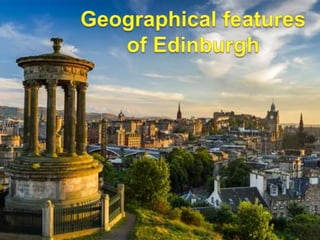
Geography of Edinburgh
•Download as PPTX, PDF•
1 like•672 views

Geography of Edinburgh: location, climate, some famous places.

Recommended
More Related Content
Similar to Geography of Edinburgh
Similar to Geography of Edinburgh (20)
Recently uploaded
Recently uploaded (20)
Geography of Edinburgh
- 2. Land and settlement Climate and weather Famous natural sites
- 3. • Landform • Settlement expansion • Population distribution
- 4. Located towards the east end of the Central Lowlands of Scotland On the south shore of the Firth of Forth occupies the undulating Lothian coastal plain
- 5. a wide diversity of habitats a remarkable range of flora and fauna many hills, river banks and flood plains
- 6. • Castle Rock • Calton Hill • Arthur’s Seat • Corstorphine Hill • Blackford Hill • Braid Hills • Craiglockhart Hills
- 7. • Nucleus on the slopes of the Castle Rock • Spreading out in all directions to encompass surrounding settlements • Expanding westward and eastward along the coastal plain • Reaching steadily towards the coast • Merging with the historic ports of Leith and Newhaven • Extending further inland.
- 8. Old Town New Town
- 9. Highest in inner suburban areas Noticeable growth of population in the areas surrounding Leith Walk (up to 30% increase) Other areas of significant growth: Dalry, Fountainbridge, Tollcross, South Side, Granton, Newhaven and Craigmillar 55% of the city’s population now live within 4 km of the centre of Edinburgh, compared with just 48% in 1981
- 11. Temperature 3 4 6 7 10 13 15 15 13 10 6 5 0 2 4 6 8 10 12 14 16 Average temperature in Edinburgh (◦C) Jan Feb Mar Apr May Jun Jul Aug Sep Oct Nov Dec
- 12. Rainfall 70 50 70 40 50 60 70 50 70 80 70 70 0 10 20 30 40 50 60 70 80 90 Average rainfall in Edinburgh (mm) jan feb mar apr may jun jul aug sep oct nov dec
- 13. Humidity - Average humidity: 80,1%/month - Windy city
- 14. 4 seasons Spring Summer Autumn Winter
- 15. 3. Famous natural sites Seven hills River: Water of Leith Parks and gardens
- 16. The most two famous hills Calton Hill National Monument The Nelson Monument The Robert Burns Monument The old Royal High School
- 17. The most two famous hills Castle Rock Edinburgh castle on top of the hill
- 19. Princes Street Gardens Holyrood Park The meadow Park Saughton Rose Garden Royal Botanic Garden Parks and gardens
- 20. • Land and settlement Landform Settlement expansion Population distribution • Climate and weather Maritime climate 4 seasons • Famous natural sites Famous hills Water of Leith Parks and gardens
- 21. References • EdinburghWeather. (2015). Edinburgh: Annual Weather Averages. Retrieved from: http://www.holiday- weather.com/edinburgh/averages • Harris, R. (2010). Topography of Edinburgh. Retrieved from: https://www.google.com.vn/url?sa=t&rct=j&q=&esrc=s&source=we b&cd=1&ved=0ahUKEwjY1Yec5bfSAhVBJ5QKHY8pCj4QFggw MAA&url=http%3A%2F%2Fwww.edinburgh.gov.uk%2Fdownload %2Fdownloads%2Fid%2F3275%2Fsoe_topography.pdf&usg=AFQ jCNFtZmAhjLl_u6DaGHHrQs9cYaKXPw • The City of Edinburgh Council. (2013). Population distribution and density in Edinburgh. Retrieved from: http://www.edinburgh.gov.uk/download/downloads/id/2942/census_ 2011_-_population_distribution_and_density.pdf • UNESCO. (2014). Old and New Towns of Edinburgh. Retrieved from: http://whc.unesco.org/en/list/728