Final presentation plan6058
•
0 likes•728 views

NOT MINE. Uploaded for embedding in a GIS Project.

Recommended
Recommended
More Related Content
Similar to Final presentation plan6058
Similar to Final presentation plan6058 (20)
Recently uploaded
Recently uploaded (20)
Final presentation plan6058
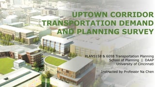
- 1. UPTOWN CORRIDOR TRANSPORTATION DEMAND AND PLANNING SURVEY PLAN5158 & 6058 Transportation Planning School of Planning | DAAP University of Cincinnati Instructed by Professor Na Chen
- 2. 1. INTRODUCTION 2. DATA INVENTORY 3. SURVEY DESIGN & IMPLEMENTATION 4. SURVEY RESULT ANALYSIS 5. CONCLUSION & RECOMMENDATION TABLE OF CONTENT
- 3. WHERE IS UPTOWN INNOVATION CORRIDOR? + Integrated into six Uptown neighborhoods + 10 minute distance from Downtown Cincinnati + Near interstate highways I-71 and I-75 INTRODUCTION
- 4. UPTOWN INNOVATION CORRIDOR + Between I-71 & I-75 interchanges + Bisected by MLK Ave and Reading Road + Located near new I-71 ramp + Located in innovation hub including research, medical and education institutes + Entire site is 70 acres
- 5. POSITIVIST APPROACH - social facts - overview of community to uncover social trends Survey-based research Questionnaire & statistical analysis Data sources: Primary research | US Census | CAGIS Perspective Methodology Methods
- 6. Site Audit & Analysis Survey Design Survey Analysis Assessment Survey Implementation 1 2 3 4 5 PROJECT FLOW & OUTCOMES
- 7. BASIC DEMOGRAPHICS Race and Ethnicity Female | Male Age by Sex 20kRESIDENTS IN A 1 MILE RADIUS AROUND THE INTERSECTION $20.9k AREA MEDIAN HOUSEHOLD INCOME (2016 $) 78% HOUSEHOLDS ARE RENTERS 76% WITHOUT A COLLEGE DEGREE DATA INVENTORY Black White Asian Multi-race Latino Other
- 8. Commute Length ANALYSIS • 28% of residents commute to work via active (walking, cycling) or public transportations, • Correspondingly, about 50% of this community has a commute less than 20 minutes Commute Mode 38%HOUSEHOLDS LACK A VEHICLE COMMUTE PATTERNS < 15 min 15-19 min 20-14 min 25-29 min 30-34 min 35-39 min 40-44 min 45-59 min > 60 min Drive alone Active transportation Public transportation Carpool Telework
- 9. Bus Stop 400 – 500 ft 250 – 400 ft 0 – 250 ft Distance from Bus Stops Parking Sidewalk Bikeway Bus Stops Sidewalks and BikewaysParking Lots TRANSPORTATION ACCESSIBILITY
- 11. DESIGN PROCESS ❖ Define the purpose ➢ Enhance the transportation system in the Uptown Corridor Area ❖ Define data collection objectives ➢ General Travel Patterns within Uptown ➢ Attitude toward mode choice & transportation system ➢ Land use & transportation infrastructure ➢ Demographic information ❖ Identify target population ➢ People who live, work, commute through the area ❖ Study Area ➢ The four blocks centered on the intersection of MLK Drive & Reading Road ❖ Select survey method ➢ Intercept survey ❖ Develop survey questionnaire ➢ Cover letter ➢ Study Area map ➢ Four sections of questions ❖ Survey Implementation ➢ Pilot survey ➢ Final survey SURVEY DESIGN & IMPLEMENTATION
- 12. SURVEY QUESTIONNAIRE § Travel Behavior a. Today b. Primary § Land Use & Infrastructure § Multimodal Transportation a. Status b. Vision § Demographic & Socioeconomic
- 15. IMPLEMENTATION +Approach + Primary: Intercept Survey + Secondary: Emailed to coworkers / other Students +Locations + Reading Road North + Reading Road South + Hospital Complex +Conducting the Survey + Off and on peak times + Our group: 18 hours + Emailed to other classes
- 17. SURVEY RESULT ANALYSYS COMBINED (ALL 3 GROUPS): • 199 surveys taken (not all complete) • Cleaned/coded • 109 variables CODEBOOK CLEANED DATA
- 18. 54% 45% 1% Prefer no answer 73% Renters 72% Bachelor's degree▲ 60% Est. HH Income $60k▲ 54% Live & Work in Uptown
- 19. (184 RESPONSES) (160 RESPONSES) WHERE DO THEY LIVE AND WORK? Work ZIP Codes Of Survey Respondents
- 20. Most Often Used Mode of Transportation 64% 15% 8% 13%
- 21. 52% 48% 75% 59% 54% “If there are improvements”
- 22. 68 % YES for Improved Multimodal Transportation System in Uptown “Oh yes, it will make my life easier & more efficient” 71% 41%“No, currently not” “Connection between different modes? Not strong…” 42% “Yes, it is”23% “Well-designed & connected multimodal transportation system?” ATTITUDES: MULTIMODAL TRANSPORTATION
- 23. “No, the environment here does not encourage me to walk nor bike.” 48% 34% “Not enough bus routes & stops” 23% “There are enough bus routes & stops” “Oh boy… you should try parking here” 48% 28% “The bus is not frequent enough” 21% “It’s frequent enough” ATTITUDES: CURRENT LAND USE & TRANSPORTATION INFRASTRUCTURE
- 24. “Yes, enough sidewalks & crosswalks” 59% 30% “But I do not feel safe using those above” 49% “Yes, I feel safe” “Bike lanes? Not enough!” 51% 36% “I do not feel safe when biking” 17%“Yes, I feel safe” “Yes, I can meet most of my daily needs here” 49%
- 25. “More mixed land uses? Oh yes, I’m going to walk & bike more.” 56% “Multimode transit hub? Yes for taking the bus more often.” 59% “Well-connected bicycle network? Oh yes, I’m going to bike more.” 48% “Streetcar goes here? Oh yes, I’ll go to work/school by that.” 58% ATTITUDES: FUTURE LAND USE & TRANSPORTATION INFRASTRUCTURE
- 26. SURVEY RESULTS:MODE CHOICE ANALYSIS • DRIVING ALONE: Reason: Saving time/Necessary • NOT DRIVING ALONE: Reason: No car/Parking fee is too expensive • NOT USING TRANSIT: Reason: Not enough facilities/buses come too infrequently • NOT BIKING: Reason: Do not own a bike/Not safe/Too hilly
- 28. PUBLIC TRANSPORTATION vs. CAR OWNERSHIP PUBLIC TRANSIT 6+ X/WEEK No Yes Yes No Prefer not to answer MODE CHOICE ANALYSIS
- 30. CONCLUSION & RECOMMENTATION • Potential for non-representative sample—would have liked more respondents • Some inconsistencies in how people responded—did not filter out incomplete or inaccurate surveys • Transportation system largely set up to support personal auto use (and walking) • Respondents had poor opinions about connectivity of system • But, with improvements, willing to use other modes of transportation POTENTIAL FOR SUCCESS OF UPTOWN TRANSPORTATION HUB (?)