SlideShare a Scribd company logo
1 of 1
Download to read offline
Dual-Polariza+on	Radar	Observa+ons	of	Precipita+on	Processes	in	Complex	Terrain	during	OLYMPEX		
Angela	K.	Rowe1,	Megan	M.	Chaplin1,	and	Robert	A.	Houze,	Jr.1,2	
1University	of	Washington,	Sea4le,	WA;	2PNNL,	Richland,	WA	


1. Introduction


2. OLYMPEX Data
The Olympic Mountains Experiment (OLYMPEX), a NASA GPM ground validation project
occurring fall 2015 – winter 2016, provided a unique opportunity to investigate precipitation
processes as wintertime mid-latitude cyclones encounter complex terrain. The extensive
instrument assets deployed during the field campaign upstream and across a range of
elevations of the Olympic Mountains allowed for documentation of orographic enhancement
of precipitation in a variety of synoptic events. As part of this observational network, ground-
based dual-polarization Doppler radars operated nearly continuously on the coast, windward
interior valley, and leeside of the mountains. These data provided unprecedented detail to
illuminate the role of terrain on microphysical and dynamical processes associated with this
precipitation enhancement. Additional details on microphysical processes are available
through in situ aircraft data, including spirals through the radar sectors.


4. 5 December 2015 Case Study


5. Conclusions


E-mail: akrowe@atmos.uw.edu
Funded by NSF Grant # AGS-1503155 and NASA Grants # NNX16AD75G, NNX15AL38G
AMS Annual Meeting, January 2017, Seattle, WA
-  Occluded frontal system
with strong wind shear
-  Strong southwesterly
winds at and above 900
hPa with slightly weaker
southeasterly flow below
-  Large drops (compared
to 12 Nov period)
observed along western
slopes suggesting
greater contribution
from melting snow
-  Shear-induced Kelvin-
Helmholtz waves
developing during time
of Citation spirals
Ø  Two cases with different synoptic/environmental conditions, varying melting levels with respect
to time and distance to terrain, upper-level enhancement over mountains (waves in 5 Dec case),
little to no liquid water observed in spirals
Ø  Observations of dendrites and capped columns in region of upper-level ZDR enhancement, with
large aggregates observed below as ZDR decreases/Z, increase providing confidence in
microphysical inferences from radar when in situ data not available
Ø  Future work to investigate dynamical processes related to upper-level enhancement, role of K-H
waves in modification of microphysics, further classification of Citation data (e.g., LWC) as a
function of T for additional cases
3. 12 November 2015 Case Study
-  Warm prefrontal flow
impinging on
mountains (W at 500
hPa, SW at 850 hPa)
-  Deep, moist, stable
layer
-  Pronounced leeside
rain shadow
-  Coordinated flights
with GPM overpass,
including Citation
spirals over NPOL and
DOW sectors
NPOL
-  NASA’s S-band dual-
polarization, Doppler radar
-  Operated from coast
(Quinault Nation)
-  Collected high-resolution
RHIs over ocean and inland
over Quinault Valley
•  Upstream influence of
mountains (air rising
before mountain, NPOL)
•  Shallow down-valley flow
(DOW)
•  Bending of brightband
toward terrain
•  Very little to no liquid
water or rime ice
encountered
•  Secondary maxima in ZDR
aloft with increasing
reflectivity below
•  Rise in melting level with
time, increasing
enhancement and role of
warm-rain processes (see
Joe Zagrodnik’s poster)
•  Small spikes in LWC
as ascends through
stratiform ice region
•  1454 UTC: Large
aggregates just before
spiral near 3 km (no
supercooled water)
•  1505 UTC: large
aggregates (~3.5 km)
•  1508 UTC: bullet
rosettes, capped
columns (~4.5 km)
•  5.5-6.5 km: irregulars
•  > 6.5 km: column
aggregates, small
crystals
DOW
-  CSWR’s X-band, dual-
polarization, Doppler on
Wheels radar
-  Located at Lake Quinault
beneath NPOL beam
-  Collected high-resolution
RHIs in Quinault Valley and
over windward slopes
DOW	radial	velocity	
UND Citation
-  LWC (King Hot Wire Probe)
-  CWC (CSI)
-  TWC (Nevzorov)
-  Cloud DSD (CDP)
-  Particle images (2D-S,
HVPS-3, CPII, 2DC)
-  Supercooled water
(Rosemount icing probe)
-  Up to 7.5 km
NPOL	and	DOW	Opera.ons		 NPOL,DOW	
EC	X-band	Opera.ons	
Aircra:	
Ground	sites	collec+ng	data	–	Rain	gauges,	Parsivels,	MRRs,	snow	
Soundings	
Focus on Citation
spirals in DOW
and NPOL RHI
sectors
OBJECTIVE
Collocate in situ data from Citation spirals
with DOW and NPOL RHIs to validate
microphysical inferences from radar data
and to investigate precipitation processes
with respect to different environmental
conditions and terrain.
NPOL	
DOW	
NPOL	PPI	
Cita.on	
OLYMPEX	
Radar	
Network	
DOW	
RHI	
DOW	PPI	
1938	UTC	
DOW	RHI	
Cita.on	
NPOL	
RHI	
DOW	RHI	(1945	UTC)	
NPOL	RHI	(1955	UTC)	
Cita.on	
LWC	
Spiral	
DOW	
RHI	
Microphysical impact of K-H waves seen in NPOL with increased and deeper
high reflectivity over terrain; occurring under relatively higher ZDR aloft
DOW	(1505	UTC)	
NPOL	
RHI	
2DS_H	
1505	UTC	
Large	aggregates	
where	Z	increasing,	
ZDR	decreasing	
with	height	
1508	UTC	
1945	UTC	
1949	UTC	
1955	UTC	
•  1945 UTC: Time of DOW RHI
above, ~3.5 km, -7°C, large
aggregates (increase Z,
decreasing ZDR)
•  1949 UTC: In between DOW and
NPOL RHIs above, ~5 km, -13°C,
aggregates, pristine stellars,
sectored plate (in region of
locally enhanced ZDR aloft)
•  1955 UTC: Time of NPOL RHI
above, ~5 km, -20°C, smaller,
irregular (low Z)
2DS_H	Probe	
Buffer	width=1280	microns	
Resolu+on:	10	microns	
NPOL	(1532	UTC)	
Olympics	from	ISS	
Cita.on	
LWC

More Related Content

What's hot

Estimating the Atlantic overturning at 26N using satellite altimetry [IUGG]
Estimating the Atlantic overturning at 26N using satellite altimetry [IUGG]Estimating the Atlantic overturning at 26N using satellite altimetry [IUGG]
Estimating the Atlantic overturning at 26N using satellite altimetry [IUGG]Eleanor Frajka-Williams
 
Monitoring ocean currents using satellite sensors
Monitoring ocean currents using satellite sensorsMonitoring ocean currents using satellite sensors
Monitoring ocean currents using satellite sensorsbealberith
 
ÖNCEL AKADEMİ: SOLID EARTH GEOPHYSICS
ÖNCEL AKADEMİ: SOLID EARTH GEOPHYSICSÖNCEL AKADEMİ: SOLID EARTH GEOPHYSICS
ÖNCEL AKADEMİ: SOLID EARTH GEOPHYSICSAli Osman Öncel
 
ÖNCEL AKADEMİ: INTRODUCTION TO GEOPHYSICS
ÖNCEL AKADEMİ: INTRODUCTION TO GEOPHYSICSÖNCEL AKADEMİ: INTRODUCTION TO GEOPHYSICS
ÖNCEL AKADEMİ: INTRODUCTION TO GEOPHYSICSAli Osman Öncel
 
Spatial-temporal Characterization of Hurricane Path using GNSS-derived Precip...
Spatial-temporal Characterization of Hurricane Path using GNSS-derived Precip...Spatial-temporal Characterization of Hurricane Path using GNSS-derived Precip...
Spatial-temporal Characterization of Hurricane Path using GNSS-derived Precip...CSCJournals
 
Multitemporal analysis Po river Prodelta
Multitemporal analysis Po river ProdeltaMultitemporal analysis Po river Prodelta
Multitemporal analysis Po river ProdeltaCiro Manzo
 
ÖNCEL AKADEMİ: INTRODUCTION TO SEISMOLOGY
ÖNCEL AKADEMİ: INTRODUCTION TO SEISMOLOGYÖNCEL AKADEMİ: INTRODUCTION TO SEISMOLOGY
ÖNCEL AKADEMİ: INTRODUCTION TO SEISMOLOGYAli Osman Öncel
 
Esters, Leonie: Evaluation of a turbulence-based description of the air-water...
Esters, Leonie: Evaluation of a turbulence-based description of the air-water...Esters, Leonie: Evaluation of a turbulence-based description of the air-water...
Esters, Leonie: Evaluation of a turbulence-based description of the air-water...Integrated Carbon Observation System (ICOS)
 
Measuring Ice Mass Loss from Melting Ice Sheets
Measuring Ice Mass Loss from Melting Ice SheetsMeasuring Ice Mass Loss from Melting Ice Sheets
Measuring Ice Mass Loss from Melting Ice SheetsChristopher Harig
 
ÖNCEL AKADEMİ: INTRODUCTION TO SEISMOLOGY
ÖNCEL AKADEMİ: INTRODUCTION TO SEISMOLOGYÖNCEL AKADEMİ: INTRODUCTION TO SEISMOLOGY
ÖNCEL AKADEMİ: INTRODUCTION TO SEISMOLOGYAli Osman Öncel
 
ÖNCEL AKADEMİ: INTRODUCTION TO SEISMOLOGY
ÖNCEL AKADEMİ: INTRODUCTION TO SEISMOLOGYÖNCEL AKADEMİ: INTRODUCTION TO SEISMOLOGY
ÖNCEL AKADEMİ: INTRODUCTION TO SEISMOLOGYAli Osman Öncel
 
ÖNCEL AKADEMİ: INTRODUCTION TO GEOPHYSICS
ÖNCEL AKADEMİ: INTRODUCTION TO GEOPHYSICSÖNCEL AKADEMİ: INTRODUCTION TO GEOPHYSICS
ÖNCEL AKADEMİ: INTRODUCTION TO GEOPHYSICSAli Osman Öncel
 
presentation_meissner.pptx
presentation_meissner.pptxpresentation_meissner.pptx
presentation_meissner.pptxgrssieee
 
5_IGARSS2011-McDonald-v1-.ppt
5_IGARSS2011-McDonald-v1-.ppt5_IGARSS2011-McDonald-v1-.ppt
5_IGARSS2011-McDonald-v1-.pptgrssieee
 
IGARSS2011_SWOT_mesoscale_morrow.ppt
IGARSS2011_SWOT_mesoscale_morrow.pptIGARSS2011_SWOT_mesoscale_morrow.ppt
IGARSS2011_SWOT_mesoscale_morrow.pptgrssieee
 
The stream power variation in a GIS environment as an index to evaluate the m...
The stream power variation in a GIS environment as an index to evaluate the m...The stream power variation in a GIS environment as an index to evaluate the m...
The stream power variation in a GIS environment as an index to evaluate the m...pierluigi de rosa
 

What's hot (20)

Estimating the Atlantic overturning at 26N using satellite altimetry [IUGG]
Estimating the Atlantic overturning at 26N using satellite altimetry [IUGG]Estimating the Atlantic overturning at 26N using satellite altimetry [IUGG]
Estimating the Atlantic overturning at 26N using satellite altimetry [IUGG]
 
GSA poster
GSA posterGSA poster
GSA poster
 
Monitoring ocean currents using satellite sensors
Monitoring ocean currents using satellite sensorsMonitoring ocean currents using satellite sensors
Monitoring ocean currents using satellite sensors
 
ÖNCEL AKADEMİ: SOLID EARTH GEOPHYSICS
ÖNCEL AKADEMİ: SOLID EARTH GEOPHYSICSÖNCEL AKADEMİ: SOLID EARTH GEOPHYSICS
ÖNCEL AKADEMİ: SOLID EARTH GEOPHYSICS
 
ÖNCEL AKADEMİ: INTRODUCTION TO GEOPHYSICS
ÖNCEL AKADEMİ: INTRODUCTION TO GEOPHYSICSÖNCEL AKADEMİ: INTRODUCTION TO GEOPHYSICS
ÖNCEL AKADEMİ: INTRODUCTION TO GEOPHYSICS
 
Spatial-temporal Characterization of Hurricane Path using GNSS-derived Precip...
Spatial-temporal Characterization of Hurricane Path using GNSS-derived Precip...Spatial-temporal Characterization of Hurricane Path using GNSS-derived Precip...
Spatial-temporal Characterization of Hurricane Path using GNSS-derived Precip...
 
Multitemporal analysis Po river Prodelta
Multitemporal analysis Po river ProdeltaMultitemporal analysis Po river Prodelta
Multitemporal analysis Po river Prodelta
 
ÖNCEL AKADEMİ: INTRODUCTION TO SEISMOLOGY
ÖNCEL AKADEMİ: INTRODUCTION TO SEISMOLOGYÖNCEL AKADEMİ: INTRODUCTION TO SEISMOLOGY
ÖNCEL AKADEMİ: INTRODUCTION TO SEISMOLOGY
 
FLARE_Brief
FLARE_BriefFLARE_Brief
FLARE_Brief
 
Esters, Leonie: Evaluation of a turbulence-based description of the air-water...
Esters, Leonie: Evaluation of a turbulence-based description of the air-water...Esters, Leonie: Evaluation of a turbulence-based description of the air-water...
Esters, Leonie: Evaluation of a turbulence-based description of the air-water...
 
Measuring Ice Mass Loss from Melting Ice Sheets
Measuring Ice Mass Loss from Melting Ice SheetsMeasuring Ice Mass Loss from Melting Ice Sheets
Measuring Ice Mass Loss from Melting Ice Sheets
 
ÖNCEL AKADEMİ: INTRODUCTION TO SEISMOLOGY
ÖNCEL AKADEMİ: INTRODUCTION TO SEISMOLOGYÖNCEL AKADEMİ: INTRODUCTION TO SEISMOLOGY
ÖNCEL AKADEMİ: INTRODUCTION TO SEISMOLOGY
 
ÖNCEL AKADEMİ: INTRODUCTION TO SEISMOLOGY
ÖNCEL AKADEMİ: INTRODUCTION TO SEISMOLOGYÖNCEL AKADEMİ: INTRODUCTION TO SEISMOLOGY
ÖNCEL AKADEMİ: INTRODUCTION TO SEISMOLOGY
 
ÖNCEL AKADEMİ: INTRODUCTION TO GEOPHYSICS
ÖNCEL AKADEMİ: INTRODUCTION TO GEOPHYSICSÖNCEL AKADEMİ: INTRODUCTION TO GEOPHYSICS
ÖNCEL AKADEMİ: INTRODUCTION TO GEOPHYSICS
 
PERMAFROST RUNOFF
PERMAFROST RUNOFFPERMAFROST RUNOFF
PERMAFROST RUNOFF
 
presentation_meissner.pptx
presentation_meissner.pptxpresentation_meissner.pptx
presentation_meissner.pptx
 
5_IGARSS2011-McDonald-v1-.ppt
5_IGARSS2011-McDonald-v1-.ppt5_IGARSS2011-McDonald-v1-.ppt
5_IGARSS2011-McDonald-v1-.ppt
 
IGARSS2011_SWOT_mesoscale_morrow.ppt
IGARSS2011_SWOT_mesoscale_morrow.pptIGARSS2011_SWOT_mesoscale_morrow.ppt
IGARSS2011_SWOT_mesoscale_morrow.ppt
 
The stream power variation in a GIS environment as an index to evaluate the m...
The stream power variation in a GIS environment as an index to evaluate the m...The stream power variation in a GIS environment as an index to evaluate the m...
The stream power variation in a GIS environment as an index to evaluate the m...
 
Watertech Booth Slide 2013
Watertech Booth Slide 2013Watertech Booth Slide 2013
Watertech Booth Slide 2013
 

Viewers also liked

Expo Money Curitiba (16 e 17-04-08)
Expo Money Curitiba (16 e 17-04-08)Expo Money Curitiba (16 e 17-04-08)
Expo Money Curitiba (16 e 17-04-08)CPFL RI
 
Stephen Keokhanthachone Resume Jan. 2017
Stephen Keokhanthachone Resume Jan. 2017Stephen Keokhanthachone Resume Jan. 2017
Stephen Keokhanthachone Resume Jan. 2017Stephen Keokhanthachone
 
Prisoners of Hope (20pg sample) 2:17
Prisoners of Hope (20pg sample) 2:17Prisoners of Hope (20pg sample) 2:17
Prisoners of Hope (20pg sample) 2:17Allen Fitz-Gerald
 
140201Atlanta_AMS_Chaplin
140201Atlanta_AMS_Chaplin140201Atlanta_AMS_Chaplin
140201Atlanta_AMS_ChaplinMegan Chaplin
 
関西地域でのオープンデータ活動の 広がりと今後の展望 -LOD(Linked Open Data)普及活動を通して-
関西地域でのオープンデータ活動の広がりと今後の展望-LOD(Linked Open Data)普及活動を通して-関西地域でのオープンデータ活動の広がりと今後の展望-LOD(Linked Open Data)普及活動を通して-
関西地域でのオープンデータ活動の 広がりと今後の展望 -LOD(Linked Open Data)普及活動を通して-Kouji Kozaki
 
Normativa Educació Infantil
Normativa Educació InfantilNormativa Educació Infantil
Normativa Educació Infantilcdalgala
 
160425Seattle_AtmosSciSeminar_Chaplin
160425Seattle_AtmosSciSeminar_Chaplin160425Seattle_AtmosSciSeminar_Chaplin
160425Seattle_AtmosSciSeminar_ChaplinMegan Chaplin
 

Viewers also liked (15)

Expo Money Curitiba (16 e 17-04-08)
Expo Money Curitiba (16 e 17-04-08)Expo Money Curitiba (16 e 17-04-08)
Expo Money Curitiba (16 e 17-04-08)
 
Stephen Keokhanthachone Resume Jan. 2017
Stephen Keokhanthachone Resume Jan. 2017Stephen Keokhanthachone Resume Jan. 2017
Stephen Keokhanthachone Resume Jan. 2017
 
Prisoners of Hope (20pg sample) 2:17
Prisoners of Hope (20pg sample) 2:17Prisoners of Hope (20pg sample) 2:17
Prisoners of Hope (20pg sample) 2:17
 
140201Atlanta_AMS_Chaplin
140201Atlanta_AMS_Chaplin140201Atlanta_AMS_Chaplin
140201Atlanta_AMS_Chaplin
 
Comité de bon voisinage Brossard - 25 janvier 2017
Comité de bon voisinage Brossard - 25 janvier 2017Comité de bon voisinage Brossard - 25 janvier 2017
Comité de bon voisinage Brossard - 25 janvier 2017
 
関西地域でのオープンデータ活動の 広がりと今後の展望 -LOD(Linked Open Data)普及活動を通して-
関西地域でのオープンデータ活動の広がりと今後の展望-LOD(Linked Open Data)普及活動を通して-関西地域でのオープンデータ活動の広がりと今後の展望-LOD(Linked Open Data)普及活動を通して-
関西地域でのオープンデータ活動の 広がりと今後の展望 -LOD(Linked Open Data)普及活動を通して-
 
Looking for China Visitor visa - Contact Sanctum Consulting
Looking for China Visitor visa - Contact Sanctum ConsultingLooking for China Visitor visa - Contact Sanctum Consulting
Looking for China Visitor visa - Contact Sanctum Consulting
 
Neumococo
NeumococoNeumococo
Neumococo
 
Normativa Educació Infantil
Normativa Educació InfantilNormativa Educació Infantil
Normativa Educació Infantil
 
5 w's of a mentor
5 w's of a mentor5 w's of a mentor
5 w's of a mentor
 
Cuadro explicativo joseph camacho
Cuadro explicativo joseph camachoCuadro explicativo joseph camacho
Cuadro explicativo joseph camacho
 
Radar Application
Radar ApplicationRadar Application
Radar Application
 
radar technology
radar technologyradar technology
radar technology
 
160425Seattle_AtmosSciSeminar_Chaplin
160425Seattle_AtmosSciSeminar_Chaplin160425Seattle_AtmosSciSeminar_Chaplin
160425Seattle_AtmosSciSeminar_Chaplin
 
Radar ppt
Radar pptRadar ppt
Radar ppt
 

Similar to 170123Seattle_AMS_OLYMPEXposter_Rowe

TU2.L10 - THE AQUARIUS/SAC-D MISSION OVERVIEW
TU2.L10 - THE AQUARIUS/SAC-D MISSION OVERVIEWTU2.L10 - THE AQUARIUS/SAC-D MISSION OVERVIEW
TU2.L10 - THE AQUARIUS/SAC-D MISSION OVERVIEWgrssieee
 
IGARSS11_DESDynI_V2.pptx
IGARSS11_DESDynI_V2.pptxIGARSS11_DESDynI_V2.pptx
IGARSS11_DESDynI_V2.pptxgrssieee
 
Grace satellite technology
Grace satellite technologyGrace satellite technology
Grace satellite technologydzbsjk
 
Presentation: Volcanic Monitoring with GPS--An Alaskan Example
Presentation: Volcanic Monitoring with GPS--An Alaskan ExamplePresentation: Volcanic Monitoring with GPS--An Alaskan Example
Presentation: Volcanic Monitoring with GPS--An Alaskan ExampleSERC at Carleton College
 
WE1.L09 - AN OVERVIEW OF THE DESDYNI MISSION
WE1.L09 - AN OVERVIEW OF THE DESDYNI MISSIONWE1.L09 - AN OVERVIEW OF THE DESDYNI MISSION
WE1.L09 - AN OVERVIEW OF THE DESDYNI MISSIONgrssieee
 
TH3.L10.1: THE NASA SOIL MOISTURE ACTIVE PASSIVE (SMAP) MISSION: OVERVIEW
TH3.L10.1: THE NASA SOIL MOISTURE ACTIVE PASSIVE (SMAP) MISSION: OVERVIEWTH3.L10.1: THE NASA SOIL MOISTURE ACTIVE PASSIVE (SMAP) MISSION: OVERVIEW
TH3.L10.1: THE NASA SOIL MOISTURE ACTIVE PASSIVE (SMAP) MISSION: OVERVIEWgrssieee
 
WE3.L10.4: KIYO TOMIYASU, CO-SEISMIC SLIP AND THE KRAFLA VOLCANO: REFLECTIONS...
WE3.L10.4: KIYO TOMIYASU, CO-SEISMIC SLIP AND THE KRAFLA VOLCANO: REFLECTIONS...WE3.L10.4: KIYO TOMIYASU, CO-SEISMIC SLIP AND THE KRAFLA VOLCANO: REFLECTIONS...
WE3.L10.4: KIYO TOMIYASU, CO-SEISMIC SLIP AND THE KRAFLA VOLCANO: REFLECTIONS...grssieee
 
Nuclear Magnetic Ressonance - Water content assessment in glacier ice and ben...
Nuclear Magnetic Ressonance - Water content assessment in glacier ice and ben...Nuclear Magnetic Ressonance - Water content assessment in glacier ice and ben...
Nuclear Magnetic Ressonance - Water content assessment in glacier ice and ben...Fundació Marcel Chevalier
 
CLIMATE CHANGE IMPACT ASSESSMENT ON MELTING GLACIERS USING RS & GIS
CLIMATE CHANGE IMPACT ASSESSMENT ON MELTING GLACIERS USING RS & GISCLIMATE CHANGE IMPACT ASSESSMENT ON MELTING GLACIERS USING RS & GIS
CLIMATE CHANGE IMPACT ASSESSMENT ON MELTING GLACIERS USING RS & GISAbhiram Kanigolla
 
Convective storms in Europe: a look back at COPS and CSIP
Convective storms in Europe: a look back at COPS and CSIPConvective storms in Europe: a look back at COPS and CSIP
Convective storms in Europe: a look back at COPS and CSIPAndrew Russell
 
CAAC_Downbursts_Fog_KP
CAAC_Downbursts_Fog_KPCAAC_Downbursts_Fog_KP
CAAC_Downbursts_Fog_KPKen Pryor
 
PosterDryden2011txt
PosterDryden2011txtPosterDryden2011txt
PosterDryden2011txtMichelle Wen
 
Different Martian Crustal Seismic Velocities across the Dichotomy Boundary fr...
Different Martian Crustal Seismic Velocities across the Dichotomy Boundary fr...Different Martian Crustal Seismic Velocities across the Dichotomy Boundary fr...
Different Martian Crustal Seismic Velocities across the Dichotomy Boundary fr...Sérgio Sacani
 
A continuum from_clear_to_cloudy_hot_jupiter_exoplanets_without_primordial_wa...
A continuum from_clear_to_cloudy_hot_jupiter_exoplanets_without_primordial_wa...A continuum from_clear_to_cloudy_hot_jupiter_exoplanets_without_primordial_wa...
A continuum from_clear_to_cloudy_hot_jupiter_exoplanets_without_primordial_wa...Sérgio Sacani
 
SPACEBORNE_MICROWAVE_OBSERVATIONS_OF_RAIN 1972-1997.ppt
SPACEBORNE_MICROWAVE_OBSERVATIONS_OF_RAIN 1972-1997.pptSPACEBORNE_MICROWAVE_OBSERVATIONS_OF_RAIN 1972-1997.ppt
SPACEBORNE_MICROWAVE_OBSERVATIONS_OF_RAIN 1972-1997.pptgrssieee
 
SPACEBORNE_MICROWAVE_OBSERVATIONS_OF_RAIN 1972-1997.ppt
SPACEBORNE_MICROWAVE_OBSERVATIONS_OF_RAIN 1972-1997.pptSPACEBORNE_MICROWAVE_OBSERVATIONS_OF_RAIN 1972-1997.ppt
SPACEBORNE_MICROWAVE_OBSERVATIONS_OF_RAIN 1972-1997.pptgrssieee
 
SPACEBORNE_MICROWAVE_OBSERVATIONS_OF_RAIN 1972-1997.ppt
SPACEBORNE_MICROWAVE_OBSERVATIONS_OF_RAIN 1972-1997.pptSPACEBORNE_MICROWAVE_OBSERVATIONS_OF_RAIN 1972-1997.ppt
SPACEBORNE_MICROWAVE_OBSERVATIONS_OF_RAIN 1972-1997.pptgrssieee
 
Weather how to read the weather maps 6.3
Weather how to read the weather maps 6.3Weather how to read the weather maps 6.3
Weather how to read the weather maps 6.3Kella Randolph
 
Monitoring surface deformation combining optical and radar sentinel data gsg ...
Monitoring surface deformation combining optical and radar sentinel data gsg ...Monitoring surface deformation combining optical and radar sentinel data gsg ...
Monitoring surface deformation combining optical and radar sentinel data gsg ...Pavlos Krassakis
 

Similar to 170123Seattle_AMS_OLYMPEXposter_Rowe (20)

TU2.L10 - THE AQUARIUS/SAC-D MISSION OVERVIEW
TU2.L10 - THE AQUARIUS/SAC-D MISSION OVERVIEWTU2.L10 - THE AQUARIUS/SAC-D MISSION OVERVIEW
TU2.L10 - THE AQUARIUS/SAC-D MISSION OVERVIEW
 
IGARSS11_DESDynI_V2.pptx
IGARSS11_DESDynI_V2.pptxIGARSS11_DESDynI_V2.pptx
IGARSS11_DESDynI_V2.pptx
 
Grace satellite technology
Grace satellite technologyGrace satellite technology
Grace satellite technology
 
Presentation: Volcanic Monitoring with GPS--An Alaskan Example
Presentation: Volcanic Monitoring with GPS--An Alaskan ExamplePresentation: Volcanic Monitoring with GPS--An Alaskan Example
Presentation: Volcanic Monitoring with GPS--An Alaskan Example
 
WE1.L09 - AN OVERVIEW OF THE DESDYNI MISSION
WE1.L09 - AN OVERVIEW OF THE DESDYNI MISSIONWE1.L09 - AN OVERVIEW OF THE DESDYNI MISSION
WE1.L09 - AN OVERVIEW OF THE DESDYNI MISSION
 
TH3.L10.1: THE NASA SOIL MOISTURE ACTIVE PASSIVE (SMAP) MISSION: OVERVIEW
TH3.L10.1: THE NASA SOIL MOISTURE ACTIVE PASSIVE (SMAP) MISSION: OVERVIEWTH3.L10.1: THE NASA SOIL MOISTURE ACTIVE PASSIVE (SMAP) MISSION: OVERVIEW
TH3.L10.1: THE NASA SOIL MOISTURE ACTIVE PASSIVE (SMAP) MISSION: OVERVIEW
 
WE3.L10.4: KIYO TOMIYASU, CO-SEISMIC SLIP AND THE KRAFLA VOLCANO: REFLECTIONS...
WE3.L10.4: KIYO TOMIYASU, CO-SEISMIC SLIP AND THE KRAFLA VOLCANO: REFLECTIONS...WE3.L10.4: KIYO TOMIYASU, CO-SEISMIC SLIP AND THE KRAFLA VOLCANO: REFLECTIONS...
WE3.L10.4: KIYO TOMIYASU, CO-SEISMIC SLIP AND THE KRAFLA VOLCANO: REFLECTIONS...
 
Nuclear Magnetic Ressonance - Water content assessment in glacier ice and ben...
Nuclear Magnetic Ressonance - Water content assessment in glacier ice and ben...Nuclear Magnetic Ressonance - Water content assessment in glacier ice and ben...
Nuclear Magnetic Ressonance - Water content assessment in glacier ice and ben...
 
Microwave remote sensing
Microwave remote sensingMicrowave remote sensing
Microwave remote sensing
 
CLIMATE CHANGE IMPACT ASSESSMENT ON MELTING GLACIERS USING RS & GIS
CLIMATE CHANGE IMPACT ASSESSMENT ON MELTING GLACIERS USING RS & GISCLIMATE CHANGE IMPACT ASSESSMENT ON MELTING GLACIERS USING RS & GIS
CLIMATE CHANGE IMPACT ASSESSMENT ON MELTING GLACIERS USING RS & GIS
 
Convective storms in Europe: a look back at COPS and CSIP
Convective storms in Europe: a look back at COPS and CSIPConvective storms in Europe: a look back at COPS and CSIP
Convective storms in Europe: a look back at COPS and CSIP
 
CAAC_Downbursts_Fog_KP
CAAC_Downbursts_Fog_KPCAAC_Downbursts_Fog_KP
CAAC_Downbursts_Fog_KP
 
PosterDryden2011txt
PosterDryden2011txtPosterDryden2011txt
PosterDryden2011txt
 
Different Martian Crustal Seismic Velocities across the Dichotomy Boundary fr...
Different Martian Crustal Seismic Velocities across the Dichotomy Boundary fr...Different Martian Crustal Seismic Velocities across the Dichotomy Boundary fr...
Different Martian Crustal Seismic Velocities across the Dichotomy Boundary fr...
 
A continuum from_clear_to_cloudy_hot_jupiter_exoplanets_without_primordial_wa...
A continuum from_clear_to_cloudy_hot_jupiter_exoplanets_without_primordial_wa...A continuum from_clear_to_cloudy_hot_jupiter_exoplanets_without_primordial_wa...
A continuum from_clear_to_cloudy_hot_jupiter_exoplanets_without_primordial_wa...
 
SPACEBORNE_MICROWAVE_OBSERVATIONS_OF_RAIN 1972-1997.ppt
SPACEBORNE_MICROWAVE_OBSERVATIONS_OF_RAIN 1972-1997.pptSPACEBORNE_MICROWAVE_OBSERVATIONS_OF_RAIN 1972-1997.ppt
SPACEBORNE_MICROWAVE_OBSERVATIONS_OF_RAIN 1972-1997.ppt
 
SPACEBORNE_MICROWAVE_OBSERVATIONS_OF_RAIN 1972-1997.ppt
SPACEBORNE_MICROWAVE_OBSERVATIONS_OF_RAIN 1972-1997.pptSPACEBORNE_MICROWAVE_OBSERVATIONS_OF_RAIN 1972-1997.ppt
SPACEBORNE_MICROWAVE_OBSERVATIONS_OF_RAIN 1972-1997.ppt
 
SPACEBORNE_MICROWAVE_OBSERVATIONS_OF_RAIN 1972-1997.ppt
SPACEBORNE_MICROWAVE_OBSERVATIONS_OF_RAIN 1972-1997.pptSPACEBORNE_MICROWAVE_OBSERVATIONS_OF_RAIN 1972-1997.ppt
SPACEBORNE_MICROWAVE_OBSERVATIONS_OF_RAIN 1972-1997.ppt
 
Weather how to read the weather maps 6.3
Weather how to read the weather maps 6.3Weather how to read the weather maps 6.3
Weather how to read the weather maps 6.3
 
Monitoring surface deformation combining optical and radar sentinel data gsg ...
Monitoring surface deformation combining optical and radar sentinel data gsg ...Monitoring surface deformation combining optical and radar sentinel data gsg ...
Monitoring surface deformation combining optical and radar sentinel data gsg ...
 

170123Seattle_AMS_OLYMPEXposter_Rowe

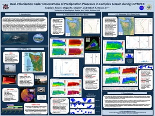
  • 1. Dual-Polariza+on Radar Observa+ons of Precipita+on Processes in Complex Terrain during OLYMPEX Angela K. Rowe1, Megan M. Chaplin1, and Robert A. Houze, Jr.1,2 1University of Washington, Sea4le, WA; 2PNNL, Richland, WA 1. Introduction 2. OLYMPEX Data The Olympic Mountains Experiment (OLYMPEX), a NASA GPM ground validation project occurring fall 2015 – winter 2016, provided a unique opportunity to investigate precipitation processes as wintertime mid-latitude cyclones encounter complex terrain. The extensive instrument assets deployed during the field campaign upstream and across a range of elevations of the Olympic Mountains allowed for documentation of orographic enhancement of precipitation in a variety of synoptic events. As part of this observational network, ground- based dual-polarization Doppler radars operated nearly continuously on the coast, windward interior valley, and leeside of the mountains. These data provided unprecedented detail to illuminate the role of terrain on microphysical and dynamical processes associated with this precipitation enhancement. Additional details on microphysical processes are available through in situ aircraft data, including spirals through the radar sectors. 4. 5 December 2015 Case Study 5. Conclusions E-mail: akrowe@atmos.uw.edu Funded by NSF Grant # AGS-1503155 and NASA Grants # NNX16AD75G, NNX15AL38G AMS Annual Meeting, January 2017, Seattle, WA -  Occluded frontal system with strong wind shear -  Strong southwesterly winds at and above 900 hPa with slightly weaker southeasterly flow below -  Large drops (compared to 12 Nov period) observed along western slopes suggesting greater contribution from melting snow -  Shear-induced Kelvin- Helmholtz waves developing during time of Citation spirals Ø  Two cases with different synoptic/environmental conditions, varying melting levels with respect to time and distance to terrain, upper-level enhancement over mountains (waves in 5 Dec case), little to no liquid water observed in spirals Ø  Observations of dendrites and capped columns in region of upper-level ZDR enhancement, with large aggregates observed below as ZDR decreases/Z, increase providing confidence in microphysical inferences from radar when in situ data not available Ø  Future work to investigate dynamical processes related to upper-level enhancement, role of K-H waves in modification of microphysics, further classification of Citation data (e.g., LWC) as a function of T for additional cases 3. 12 November 2015 Case Study -  Warm prefrontal flow impinging on mountains (W at 500 hPa, SW at 850 hPa) -  Deep, moist, stable layer -  Pronounced leeside rain shadow -  Coordinated flights with GPM overpass, including Citation spirals over NPOL and DOW sectors NPOL -  NASA’s S-band dual- polarization, Doppler radar -  Operated from coast (Quinault Nation) -  Collected high-resolution RHIs over ocean and inland over Quinault Valley •  Upstream influence of mountains (air rising before mountain, NPOL) •  Shallow down-valley flow (DOW) •  Bending of brightband toward terrain •  Very little to no liquid water or rime ice encountered •  Secondary maxima in ZDR aloft with increasing reflectivity below •  Rise in melting level with time, increasing enhancement and role of warm-rain processes (see Joe Zagrodnik’s poster) •  Small spikes in LWC as ascends through stratiform ice region •  1454 UTC: Large aggregates just before spiral near 3 km (no supercooled water) •  1505 UTC: large aggregates (~3.5 km) •  1508 UTC: bullet rosettes, capped columns (~4.5 km) •  5.5-6.5 km: irregulars •  > 6.5 km: column aggregates, small crystals DOW -  CSWR’s X-band, dual- polarization, Doppler on Wheels radar -  Located at Lake Quinault beneath NPOL beam -  Collected high-resolution RHIs in Quinault Valley and over windward slopes DOW radial velocity UND Citation -  LWC (King Hot Wire Probe) -  CWC (CSI) -  TWC (Nevzorov) -  Cloud DSD (CDP) -  Particle images (2D-S, HVPS-3, CPII, 2DC) -  Supercooled water (Rosemount icing probe) -  Up to 7.5 km NPOL and DOW Opera.ons NPOL,DOW EC X-band Opera.ons Aircra: Ground sites collec+ng data – Rain gauges, Parsivels, MRRs, snow Soundings Focus on Citation spirals in DOW and NPOL RHI sectors OBJECTIVE Collocate in situ data from Citation spirals with DOW and NPOL RHIs to validate microphysical inferences from radar data and to investigate precipitation processes with respect to different environmental conditions and terrain. NPOL DOW NPOL PPI Cita.on OLYMPEX Radar Network DOW RHI DOW PPI 1938 UTC DOW RHI Cita.on NPOL RHI DOW RHI (1945 UTC) NPOL RHI (1955 UTC) Cita.on LWC Spiral DOW RHI Microphysical impact of K-H waves seen in NPOL with increased and deeper high reflectivity over terrain; occurring under relatively higher ZDR aloft DOW (1505 UTC) NPOL RHI 2DS_H 1505 UTC Large aggregates where Z increasing, ZDR decreasing with height 1508 UTC 1945 UTC 1949 UTC 1955 UTC •  1945 UTC: Time of DOW RHI above, ~3.5 km, -7°C, large aggregates (increase Z, decreasing ZDR) •  1949 UTC: In between DOW and NPOL RHIs above, ~5 km, -13°C, aggregates, pristine stellars, sectored plate (in region of locally enhanced ZDR aloft) •  1955 UTC: Time of NPOL RHI above, ~5 km, -20°C, smaller, irregular (low Z) 2DS_H Probe Buffer width=1280 microns Resolu+on: 10 microns NPOL (1532 UTC) Olympics from ISS Cita.on LWC