1. T
"Ý"Ý
"Ý
> 2
n
USHWY51
COUNTY RD G
E MAIN ST
STATERD17
E 14TH ST
BIG
EDDY
RD
THIELMAN ST
GOLF DR
COUNTYRDW
E 6TH ST
NMEMORIALDR
JOHNSONST
E 10TH ST
STATE RD 64
RIVER ST
E 8TH ST
PINERIDGEAV
EAGLEDR
STURDEVANT ST
SEMLING RD
SUNSHINERD
GEMST
RIOGRANDEDR
COTEY
DR
BLUEBIRD
LN
JADEST
NICKELLN
OPALST
PEARLST
SCHUSTER LN
AMBERST
RUBYLN
N RIO GRANDE DR
MEMORIALDR
TOPAZST
USHWY51
Town of Merrill
CityofMerrill
TownofPineRiver
Town of
Pine River
City of Merrill
¡¢51
"·107
¡¢51
"·17
"·64
"ÿW
"ÿK
"ÿQ
"ÿG
"ÿK
"·64
"ÿZ
"·17
³±
JJ
"·107
"ÿG
"ÿK
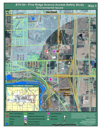
STH 64 - Pine Ridge Avenue Access Safety StudySTH 64 - Pine Ridge Avenue Access Safety Study
Environmental IssuesEnvironmental Issues
City of Merrill - Wisconsin
North Central
Wisconsin Regional
Planning Commission
M0 1,000 2,000500
Feet
This map is neither a legally recorded map nor a survey
and is not intended to be used as one. This drawing is
a compilation of records, information and data used for
reference purposes only. NCWRPC is not responsible for
any inaccuracies herein contained.
210 McClellan St., Wausau WI
www.ncwrpc.org
Preparded By:
Map 4Map 4
Minor Civil Divisions
Project Boundary
Roads
Water
Wellhead Protection Area "Ý Cemetery
Excavation Waste2
Wet Areas
Former Sludge PitT
Parcels Stormwater Retention Site>
Land DepressionnWetlands