Submit Search
Upload
Experimental catchments_Honduras
•
Download as PPTX, PDF
•
0 likes
•
26 views
L
Luis Caballero Bonilla
Follow
Report
Share
Report
Share
1 of 2
Download now
Recommended
This paper describes the application of a spatially distributed hydrological model WetSpa (Water and Energy Transfer between Soil, Plants and Atmosphere) using radar-based rainfall data provide by the United States Hydrology Laboratory of NOAA's National Weather Service for a distributed model intercomparison project. The model is applied to the river basin above Tahlequah hydrometry station with 30-m spatial resolution and one hour time--step for a total simulation period of 6 years. Rainfall inputs are derived from radar. The distributed model parameters are based on an extensive database of watershed characteristics available for the region, including digital maps of DEM, soil type, and land use. The model is calibrated and validated on part of the river flow records. The simulated hydrograph shows a good correspondence with observation (Nash efficiency coeffiecient >80%, indicating that the model is able to simulate the relevant hydrologic processes in the basin accurately.
Streamflow simulation using radar-based precipitation applied to the Illinois...
Streamflow simulation using radar-based precipitation applied to the Illinois...
Alireza Safari
Bathymetry software
Bathymetry software
hydrologyproject0
презентация Зуевской общеобразовательной школы №11
презентация Зуевской общеобразовательной школы №11
panasyanta
Defense
Defense
Hong Li
Hydrographic echo sounders are used to measure the depth to the seafloor by using the properties of acoustic waves. The principle of echo-sounders is basic - by measuring the two-way travel time between the acoustic waves transmitted on sea surface and those reflected at seafloor. In this study, an integrated approach for hydrographic surveying is introduced and evaluated in terms of its efficiency in comparison with the traditional methods of hydrographic surveying. The approach develops an integrated environment of hydrographic surveying comprising human, hardware and software. The process of surveying starts from in-house planning using specialized geo-spatial softwares. Then, on site a combination of computer hardware, echosounder, differential global positioning system (DGPS), survey vessel and survey crew is made. Post-processing is performed after conducting a survey in order to improve quality of data by filtering errors and producing the end product like reservoir underwater terrain, development of reservoir stage-area and stage-storage relationships, etc. The study was applied to Tarbela Reservoir, Pakistan.
SyQwest Bathy-2010 Sub Bottom Profiler used in Tarbela Reservoir Study
SyQwest Bathy-2010 Sub Bottom Profiler used in Tarbela Reservoir Study
SyQwest Inc.
In the agroecological zone of the Biemso basin in the Ashanti Region of Ghana, soil erodibility and rainfall erosivity patterns were estimated. The study aimed at investigating the temporal variability of rainfall erosivity using the Fournier Index Method and assessing the soil erodibility parameters of a Sawah site using the WEPP model. Four plots representing the major land uses in the area for maize, oil palm, natural vegetation and plantain cultivation were selected. Results showed that soil organic matter content ranged from 1.95 to 5.52%; sand ranged from 14.34 to 31.86 %; silt ranged from 31.63 to 68.77%; clay ranged from 16.04 to 20.08% and very fine sand from 3.38 to 8.84%. The derived interrill erodibility (Ki) values ranged from 44.26 to 51.70 kg s m-4 under all land uses considered at the study site and soils in the study area were moderately resistant to erosion by raindrops. The derived rill erodibility (Kr) values ranged from 0.005 to 0.012 s m-1 under all land uses considered at the study site. Rill erodibility values were higher at the foot slopes under all land uses except under Oil Palm land use. Rainfall values exceeded the 20-25 mm threshold value for erosive rains. Erosivity values determined for the study site revealed a moderate erosion risk in the major rainy season (April-July); low erosion risk in the minor rainy season (August-October ) and very low erosion risk in the dry season (November-March). It is recommended that soil and land management practices that would reduce water erosion during the major rainy season should be implemented such as bunding, mulching and contour farming.
ESTIMATION OF SOIL ERODIBILITY AND RAINFALL EROSIVITY FOR THE BIEMSO BASIN, G...
ESTIMATION OF SOIL ERODIBILITY AND RAINFALL EROSIVITY FOR THE BIEMSO BASIN, G...
Eric Takyi Atakora , Ph.D (candidate)
ce235-eh-lec-2
ce235-eh-lec-2
Sajjad Ahmad
Chapter 3 surface water hydrology
Chapter 3 surface water hydrology
Mohammed Salahat
Anexo 7 informe MIC Luis Caballero
Anexo 7 informe MIC Luis Caballero
Luis Caballero Bonilla
Hydrology of a cloudforest in La Tigra Honduras
Hydrology of a cloudforest in La Tigra Honduras
Luis Caballero Bonilla
Western Honduras VA_ENGLISH_CLEARED
Western Honduras VA_ENGLISH_CLEARED
Luis Caballero Bonilla
Contribuciones al Manejo de Cuencas por Zamorano
Contribuciones al Manejo de Cuencas por Zamorano
Luis Caballero Bonilla
Southern%20Honduras%20Vulnerability%20Assessment%20Report_CLEARED
Southern%20Honduras%20Vulnerability%20Assessment%20Report_CLEARED
Luis Caballero Bonilla
2013_61_1_Caballero_9
2013_61_1_Caballero_9
Luis Caballero Bonilla
More Related Content
More from Luis Caballero Bonilla
Anexo 7 informe MIC Luis Caballero
Anexo 7 informe MIC Luis Caballero
Luis Caballero Bonilla
Hydrology of a cloudforest in La Tigra Honduras
Hydrology of a cloudforest in La Tigra Honduras
Luis Caballero Bonilla
Western Honduras VA_ENGLISH_CLEARED
Western Honduras VA_ENGLISH_CLEARED
Luis Caballero Bonilla
Contribuciones al Manejo de Cuencas por Zamorano
Contribuciones al Manejo de Cuencas por Zamorano
Luis Caballero Bonilla
Southern%20Honduras%20Vulnerability%20Assessment%20Report_CLEARED
Southern%20Honduras%20Vulnerability%20Assessment%20Report_CLEARED
Luis Caballero Bonilla
2013_61_1_Caballero_9
2013_61_1_Caballero_9
Luis Caballero Bonilla
More from Luis Caballero Bonilla
(6)
Anexo 7 informe MIC Luis Caballero
Anexo 7 informe MIC Luis Caballero
Hydrology of a cloudforest in La Tigra Honduras
Hydrology of a cloudforest in La Tigra Honduras
Western Honduras VA_ENGLISH_CLEARED
Western Honduras VA_ENGLISH_CLEARED
Contribuciones al Manejo de Cuencas por Zamorano
Contribuciones al Manejo de Cuencas por Zamorano
Southern%20Honduras%20Vulnerability%20Assessment%20Report_CLEARED
Southern%20Honduras%20Vulnerability%20Assessment%20Report_CLEARED
2013_61_1_Caballero_9
2013_61_1_Caballero_9
Experimental catchments_Honduras
1.
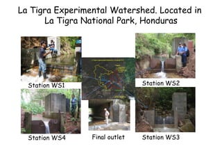
Station WS4 Station WS2Station
WS1 Station WS3Final outlet La Tigra Experimental Watershed. Located in La Tigra National Park, Honduras
2.
0 10 20 30 40 50 60 70 6/19/05 6/20/05 6/21/05 6/22/05 6/23/05 6/24/05 6/25/05 6/26/05 6/27/05 6/28/05 6/29/05 6/30/05 Tiempo (Días) Caudal(l/s) 0 10 20 30 40 50 60 70 Precipitación(mm) Precipitación Caudal Capiro-Zapotillo
paired experimental watersheds Zamorano, Honduras
Download now