More Related Content
Similar to Project 4 Sampson (20)
Project 4 Sampson
- 1. 226.37796
229.658798
232.939636
223.097107
219.816269
216.535431
236.220474
213.254593
242.78215
239.501312
246.062988
252.62468
249.343842
209.973755
255.905518
259.18634
206.692917
259.18634
226.37796
232.939636
219.816269
249.343842
206.692917
226.37796
252.62468
239.501312
236.220474
226.37796
229.658798
223.097107
236.220474
223.097107
246.062988
249.343842
226.37796
223.097107
255.905518
232.939636
232.939636
219.816269
216.535431
242.78215
249.343842
223.097107
223.097107
242.78215
223.097107
219.816269
246.062988
232.939636
252.62468
255.905518
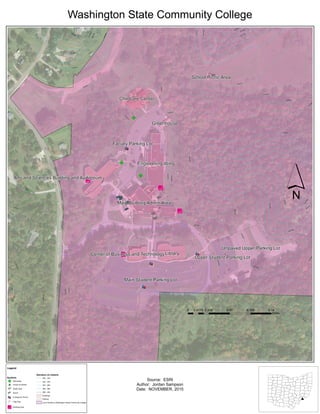
Main Student Parking Lot
Faculty Parking Lot
Unpaved Upper Parking Lot
Upper Student Parking Lot
Library
Engineering Wing
Main Building/Admin Area
Childcare Center
Arts and Sciences Building and Auditorium
Center of Business and Technology
Greenhouse
School Picnic Area
Sources: Esri, HERE, DeLorme, USGS, Intermap, increment P Corp., NRCAN, Esri Japan, METI, Esri China (Hong Kong), Esri (Thailand), MapmyIndia, © OpenStreetMap contributors, and the GIS User Community, Source: Esri, DigitalGlobe,
GeoEye, Earthstar Geographics, CNES/Airbus DS, USDA, USGS, AEX, Getmapping, Aerogrid, IGN, IGP, swisstopo, and the GIS User Community
´
0 0.035 0.07 0.105 0.140.0175
Miles
Washington State Community College
Legend
Symbols
Elevation (in meters)
GF Memorials
^_ Points of Interest
Bench
Break Spot
Emergency Phone
Flag Pole
!« Smoking Area
200 - 220
220 - 240
240 - 260
260 - 280
280 - 300
Buildings
Parking
Land Owned by Washington State Community College
Source: ESRI
Author: Jordan Sampson
Date: NOVEMBER, 2015
Text
#