IP_Map_Payne
- 1. Esri, HERE, DeLorme, MapmyIndia, © OpenStreetMap contributors, and the GIS user community
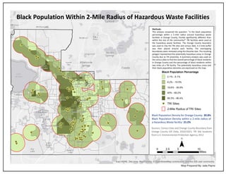
Black Population Within 2-Mile Radius of Hazardous Waste Facilities
Map Prepared By: Jade Payne
Black Population Percentage
0.1% - 8.1%
8.2% - 19.5%
19.6% - 39.9%
40% - 69.2%
69.3% - 96.4%
cG TRI Sites
2-Mile Radius of TRI Sites
¯
Methods:
This analysis answered the question: "Is the black population
percentage within a 2-mile radius around hazardous waste
facilities in Orange County, Florida significantly different than
within the rest of the community?" TRI facilities were used as
the hazardous waste facilities. The Orange County boundary
was used to Clip the TRI sites and census data. A 2-mile buffer
was then placed around each facility. The overlapping
boundaries were removed using the Dissolve tool. The resulting
polygon represented the potentially hazardous areas in Orange
County due to TRI proximity. A Summary analysis was used on
the census data to find the overall percentage of black residents
in Orange County and the percentage of black residents within
two miles of a TRI facility. The potentially hazardous areas and
their black population densities are expressed on the map.
0 5 102.5
Miles
Sources: Census Data and Orange County Boundary from
Orange County GIS Data, 2010/2015; TRI Site locations
from U.S. Environmental Protection Agency, 2012
Black Population Density for Orange County: 20.8%
Black Population Density within a 2-mile radius of
a Hazardous Waste facility: 21.2%